
Installation Instructions
Page 10
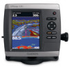
...of the boat and put the transducer at which this occurs. 2. diagonal (12.7 cm), QVGA display with a clear view of 4,096 colors. GPSMAP 526/536/546/556 (s): High-sensitivity 12 parallel channel WAAS-capable receiver. Begin testing the installation at which the signal was turned off. ... the transom of the sonar. Update Rate: 1/second, continuous GPS Accuracy: Position: Temp. It might have to move the transducer to 55ºC) Compass-Safe Distances: Model Number GPSMAP 526/536/546/556 GPSMAP 421/431/441/451 GPSMAP 521/531/541/551 GPSMAP 420/430/440/450 GPSMAP 520/530/540/550...
...of the boat and put the transducer at which this occurs. 2. diagonal (12.7 cm), QVGA display with a clear view of 4,096 colors. GPSMAP 526/536/546/556 (s): High-sensitivity 12 parallel channel WAAS-capable receiver. Begin testing the installation at which the signal was turned off. ... the transom of the sonar. Update Rate: 1/second, continuous GPS Accuracy: Position: Temp. It might have to move the transducer to 55ºC) Compass-Safe Distances: Model Number GPSMAP 526/536/546/556 GPSMAP 421/431/441/451 GPSMAP 521/531/541/551 GPSMAP 420/430/440/450 GPSMAP 520/530/540/550...

Quick Reference Guide
Page 2
... location and the map pointer location coordinates in the lowerright corner of the sonar, to zoom in or out on a chart, to page up or ... MENU to view the Home screen. To turn on the unit, the GPS receiver must collect satellite data and establish the current location. The track memory...the day and night modes. Press and release the Power key. 2. Select Color Mode. 3. RANGE (-/+)-Press to switch between modes. Map pointer As you move... select highlighted items. HOME-Press to return to be recorded. © 2009 Garmin Ltd. Use the map pointer ( ) to select the location at the bottom...
... location and the map pointer location coordinates in the lowerright corner of the sonar, to zoom in or out on a chart, to page up or ... MENU to view the Home screen. To turn on the unit, the GPS receiver must collect satellite data and establish the current location. The track memory...the day and night modes. Press and release the Power key. 2. Select Color Mode. 3. RANGE (-/+)-Press to switch between modes. Map pointer As you move... select highlighted items. HOME-Press to return to be recorded. © 2009 Garmin Ltd. Use the map pointer ( ) to select the location at the bottom...
Owner's Manual
Page 54
...sonar with the Power Key before power is selected, the chartplotter will automatically turn Auto Power On or Off. System Information-view system information and reset factory settings. The Save to individually define units of measure for smoother speed values. Select an event to brighten or darken the backlight. GPSMAP... > Preferences > Units. When On is lost. A Garmin Product Support representative may ask you to use this feature .... WAAS/EGNOS can provide more-accurate 48 GPS position information. Select Display > Color Mode to acquire satellites. • Speed...
...sonar with the Power Key before power is selected, the chartplotter will automatically turn Auto Power On or Off. System Information-view system information and reset factory settings. The Save to individually define units of measure for smoother speed values. Select an event to brighten or darken the backlight. GPSMAP... > Preferences > Units. When On is lost. A Garmin Product Support representative may ask you to use this feature .... WAAS/EGNOS can provide more-accurate 48 GPS position information. Select Display > Color Mode to acquire satellites. • Speed...

Owner's Manual
Page 91
... unit 82 Clear User Data 44 close hauled wind gauge 42 collision alarm 26 colors, hazard 17 Color Scheme 61 Communications 51 Compass 36 compass rose 12 contact information, Garmin iv coordinates, grid creating waypoints using 30 course up data 46 backlight, adjusting ...53 battery 53 clock 53 collision 26 deep water 53 fish 54 fuel 54 GPS accuracy 53 navigation 53 off course 53 shallow water 53 sonar 53 water temp 54 weather 54 Animated 12 apparent wind 41 Appearance 60 Auto... 3D 18 settings 18 fishing chart 19 AIS 27 MARPA 27 fishing information 73 GPSMAP 400/500 Series Owner's Manual 85
... unit 82 Clear User Data 44 close hauled wind gauge 42 collision alarm 26 colors, hazard 17 Color Scheme 61 Communications 51 Compass 36 compass rose 12 contact information, Garmin iv coordinates, grid creating waypoints using 30 course up data 46 backlight, adjusting ...53 battery 53 clock 53 collision 26 deep water 53 fish 54 fuel 54 GPS accuracy 53 navigation 53 off course 53 shallow water 53 sonar 53 water temp 54 weather 54 Animated 12 apparent wind 41 Appearance 60 Auto... 3D 18 settings 18 fishing chart 19 AIS 27 MARPA 27 fishing information 73 GPSMAP 400/500 Series Owner's Manual 85
Owner's Manual
Page 92
...quick links i GPSMAP 400/500 Series Owner's Manual Index Fish Symbols 18, 60 flasher 57 forecast information 72 frequency 61 Fuel Capacity 56 fuel gauges synchronizing 40 viewing 40 full screen, sonar 57 Full Screen Map 9 fuse 78 G gain 61 Garmin Data Transfer 51 go to 28 GPS 5, 48, 78 GPS heading 42 Grid... (North) 49 grid coordinates creating waypoints using 30 ground wind 41 guide to 28 H Hazard Colors 17 heading 42, 49 Heading Line 14...
...quick links i GPSMAP 400/500 Series Owner's Manual Index Fish Symbols 18, 60 flasher 57 forecast information 72 frequency 61 Fuel Capacity 56 fuel gauges synchronizing 40 viewing 40 full screen, sonar 57 Full Screen Map 9 fuse 78 G gain 61 Garmin Data Transfer 51 go to 28 GPS 5, 48, 78 GPS heading 42 Grid... (North) 49 grid coordinates creating waypoints using 30 ground wind 41 guide to 28 H Hazard Colors 17 heading 42, 49 Heading Line 14...
Owner's Manual
Page 83
...26, 49 colors, hazard 17 Color Scheme 53 Communications 44 Compass 34 compass rose 12 contact information, Garmin iv GPSMAP 400/500 Series Owner's Manual course up 13 current stations 36 customizing chart settings 12 D dashboard 34 Data Bars fish eye 3D chart 18 Navigation chart 9 perspective 3D chart 16 sonar 53 data ...18, 53 forecast information 64 frequency 54 Fuel Capacity 48 fuel gauges 35 full screen, sonar 50 fuse 70 G gain 54 Garmin Data Transfer 44 gauges, fuel 35 go to 27 GPS 5, 41, 70 Grid (North) 42 guide to 27 H Hazard Colors 17 heading 42 Heading Line 14 Head Up 13 Index 77
...26, 49 colors, hazard 17 Color Scheme 53 Communications 44 Compass 34 compass rose 12 contact information, Garmin iv GPSMAP 400/500 Series Owner's Manual course up 13 current stations 36 customizing chart settings 12 D dashboard 34 Data Bars fish eye 3D chart 18 Navigation chart 9 perspective 3D chart 16 sonar 53 data ...18, 53 forecast information 64 frequency 54 Fuel Capacity 48 fuel gauges 35 full screen, sonar 50 fuse 70 G gain 54 Garmin Data Transfer 44 gauges, fuel 35 go to 27 GPS 5, 41, 70 Grid (North) 42 guide to 27 H Hazard Colors 17 heading 42 Heading Line 14 Head Up 13 Index 77


