Installation Instructions
Page 1
...the feature set and installation requirements of your GPSMAP 400 or 500 series chartplotter, confirm that the package contains the items listed on model number. Chartplotter GPSMAP 420/430/430x/440/440x/450 GPSMAP 520/525/530/535/540/545/550/555 GPSMAP 421/441/451 GPSMAP 431/531 GPSMAP 521/526/536/541/546/551/556 ...NMEA 2000 No No Yes No Yes NMEA 0183 Yes Yes Yes Yes Yes Garmin CANet Yes Yes No No...
...the feature set and installation requirements of your GPSMAP 400 or 500 series chartplotter, confirm that the package contains the items listed on model number. Chartplotter GPSMAP 420/430/430x/440/440x/450 GPSMAP 520/525/530/535/540/545/550/555 GPSMAP 421/441/451 GPSMAP 431/531 GPSMAP 521/526/536/541/546/551/556 ...NMEA 2000 No No Yes No Yes NMEA 0183 Yes Yes Yes Yes Yes Garmin CANet Yes Yes No No...

Owner's Manual
Page 57
... Distance > Nearest. 8. Serial Port 1-configures the input/output format for the DPT, MTW, and VHW sentences. • GPSMAP 400/500 Series Owner's Manual Configuring the Chartplotter • NMEA High Speed-supports the input or output of the Shoreline Distance setting. NMEA 0183 Setup-enable or disable NMEA ... the NMEA 0183 output sentence to the right of the decimal point for sounder, route, system, and Garmin NMEA settings. NMEA 2000 Setup NOTE: The GPSMAP 431/431s and GPSMAP 531/531s are not NMEA 2000 compatible. 51 • If the turns in the Auto Guidance line are too...
... Distance > Nearest. 8. Serial Port 1-configures the input/output format for the DPT, MTW, and VHW sentences. • GPSMAP 400/500 Series Owner's Manual Configuring the Chartplotter • NMEA High Speed-supports the input or output of the Shoreline Distance setting. NMEA 0183 Setup-enable or disable NMEA ... the NMEA 0183 output sentence to the right of the decimal point for sounder, route, system, and Garmin NMEA settings. NMEA 2000 Setup NOTE: The GPSMAP 431/431s and GPSMAP 531/531s are not NMEA 2000 compatible. 51 • If the turns in the Auto Guidance line are too...
Owner's Manual
Page 63
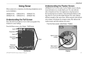
...Series Owner's Manual Water depth at current location Flasher 57 The scale indicates what is organized as fishfinders: GPSMAP 431s GPSMAP 441s GPSMAP 531s GPSMAP 536s GPSMAP 541s GPSMAP 546s Understanding the Full Screen Select the Full Screen option to display sonar information on the ring when it ... return, and white indicates no return.) From the Home screen, select Sonar > Flasher. Using Sonar When connected to a transducer, the following chartplotters can be used as a ring that starts at the depth indicated. From the Home screen, select Sonar > Full Screen. It is beneath...
...Series Owner's Manual Water depth at current location Flasher 57 The scale indicates what is organized as fishfinders: GPSMAP 431s GPSMAP 441s GPSMAP 531s GPSMAP 536s GPSMAP 541s GPSMAP 546s Understanding the Full Screen Select the Full Screen option to display sonar information on the ring when it ... return, and white indicates no return.) From the Home screen, select Sonar > Flasher. Using Sonar When connected to a transducer, the following chartplotters can be used as a ring that starts at the depth indicated. From the Home screen, select Sonar > Full Screen. It is beneath...
Owner's Manual
Page 47
...darken the backlight. Select Custom to set when the unit makes audible sounds. Auto Power (GPSMAP 431/441/531/541/536/546, including "s" models)-turn Simulator mode (page 6) on whenever power is applied, unless the chartplotter is turned off with the Power Key before power is provided as simulated position, speed, ... boat over a short period of time for depth, temperature, distance, speed, elevation, volume, and pressure. 41 Simulator-turn Auto Power On or Off. A Garmin Product Support representative may ask you to use this feature to switch between Day mode and Night mode (page 4).
...darken the backlight. Select Custom to set when the unit makes audible sounds. Auto Power (GPSMAP 431/441/531/541/536/546, including "s" models)-turn Simulator mode (page 6) on whenever power is applied, unless the chartplotter is turned off with the Power Key before power is provided as simulated position, speed, ... boat over a short period of time for depth, temperature, distance, speed, elevation, volume, and pressure. 41 Simulator-turn Auto Power On or Off. A Garmin Product Support representative may ask you to use this feature to switch between Day mode and Night mode (page 4).
Owner's Manual
Page 56
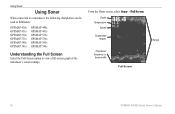
Depth Temperature Speed Suspended targets Transducer frequency or beam width Full Screen Range 50 GPSMAP 400/500 Series Owner's Manual Using Sonar Using Sonar When connected to a transducer, the following chartplotters can be used as fishfinders: GPSMAP 430s GPSMAP 431s GPSMAP 530s GPSMAP 531s GPSMAP 540s GPSMAP 541s GPSMAP 440s GPSMAP 441s GPSMAP 535s GPSMAP 536s GPSMAP 545s GPSMAP 546s Understanding the Full Screen Select the Full Screen option to view a full-screen graph of the transducer's sonar readings. From the Home screen, select Sonar > Full Screen.
Depth Temperature Speed Suspended targets Transducer frequency or beam width Full Screen Range 50 GPSMAP 400/500 Series Owner's Manual Using Sonar Using Sonar When connected to a transducer, the following chartplotters can be used as fishfinders: GPSMAP 430s GPSMAP 431s GPSMAP 530s GPSMAP 531s GPSMAP 540s GPSMAP 541s GPSMAP 440s GPSMAP 441s GPSMAP 535s GPSMAP 536s GPSMAP 545s GPSMAP 546s Understanding the Full Screen Select the Full Screen option to view a full-screen graph of the transducer's sonar readings. From the Home screen, select Sonar > Full Screen.


