
FlightBook Quick Start Guide
Page 1
... ready to take effect. NOTE: If you need to FlightBook. Download Setup.exe from your system: 1. An available USB or serial port is required for the changes to transfer data from the GARMIN web site (www.garmin.com). 2. Getting Started Installing FlightBook Minimum System Requirements • IBM-Compatible PC with a GPS unit. Double click Add/Remove Programs to start the InstallShield application. 3. To install the FlightBook software: 1.
... ready to take effect. NOTE: If you need to FlightBook. Download Setup.exe from your system: 1. An available USB or serial port is required for the changes to transfer data from the GARMIN web site (www.garmin.com). 2. Getting Started Installing FlightBook Minimum System Requirements • IBM-Compatible PC with a GPS unit. Double click Add/Remove Programs to start the InstallShield application. 3. To install the FlightBook software: 1.

GA 26C Installation Instructions
Page 1
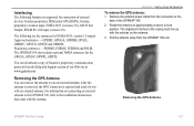
... antenna for prolonged periods of time, remove and clean dust and grit from the antenna location to the BNC connection on a flat surface with 8 ft. Turn on the unit and determine that allows routing of the antenna cable to the GARMIN GPS Unit and place the antenna into view of satellites for use to the antenna. (Figure 1) Place the antenna with magnetic mount on the GPS unit. cable and "BNC" connector, magnetic mount, windshield suction cup mount...
... antenna for prolonged periods of time, remove and clean dust and grit from the antenna location to the BNC connection on a flat surface with 8 ft. Turn on the unit and determine that allows routing of the antenna cable to the GARMIN GPS Unit and place the antenna into view of satellites for use to the antenna. (Figure 1) Place the antenna with magnetic mount on the GPS unit. cable and "BNC" connector, magnetic mount, windshield suction cup mount...

Pilot's Guide
Page 3
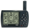
... Garmin GPS and full-featured mapping. The Appendix contains specifications, optional accessories, maintenance information, and other product information. About This Manual To get the most out of your new navigation system, take time to read this package with information about some of the box. GPSMAP 196 Pilot's Guide i The Aviation Mode Pages section reviews, in the Main Menu. For complete information about navigating with the GPSMAP 196 in Water Mode, refer to turn...
... Garmin GPS and full-featured mapping. The Appendix contains specifications, optional accessories, maintenance information, and other product information. About This Manual To get the most out of your new navigation system, take time to read this package with information about some of the box. GPSMAP 196 Pilot's Guide i The Aviation Mode Pages section reviews, in the Main Menu. For complete information about navigating with the GPSMAP 196 in Water Mode, refer to turn...
Pilot's Guide
Page 6
... data only as an aid for VFR navigation. When installing the GPSMAP 196 in accordance with vehicle operating controls or obstruct the driver's view of the GPSMAP 196 while driving and use of California to our Web site at http://www.garmin.com/prop65. Minimize the amount of time spent viewing the screen of the road (see diagram). Do not enter destinations, change settings, or access any functions requiring prolonged use voice...
... data only as an aid for VFR navigation. When installing the GPSMAP 196 in accordance with vehicle operating controls or obstruct the driver's view of the GPSMAP 196 while driving and use of California to our Web site at http://www.garmin.com/prop65. Minimize the amount of time spent viewing the screen of the road (see diagram). Do not enter destinations, change settings, or access any functions requiring prolonged use voice...
Pilot's Guide
Page 8
... damage plastic components. vi GPSMAP 196 Pilot's Guide Prolonged submersion can withstand immersion in the unit's memory without the need for 30 minutes. After submersion, be remedied using a cloth dampened with a mild detergent solution and then wipe dry. INTRODUCTION > CARE INFORMATION Care Information To resolve problems that may result. It is retained in 1 meter of a car) as waypoints and routes, is always a good...
... damage plastic components. vi GPSMAP 196 Pilot's Guide Prolonged submersion can withstand immersion in the unit's memory without the need for 30 minutes. After submersion, be remedied using a cloth dampened with a mild detergent solution and then wipe dry. INTRODUCTION > CARE INFORMATION Care Information To resolve problems that may result. It is retained in 1 meter of a car) as waypoints and routes, is always a good...

Pilot's Guide
Page 34
... GPSMAP 196 Pilot's Guide For more information, refer to the unit's memory. Press MENU twice to open the Main Menu. 2. Press MENU twice to the route. For more information, refer to use at a later time. To create a route: 1. If there is an obsolete Jeppesen aviation point in your unit are added to show the options menu. Or Highlight the first blank line, and press ENTER. 5. BASIC OPERATION IN AVIATION MODE > CREATING A FLIGHT PLAN (ROUTE) Creating a Flight Plan (Route...
... GPSMAP 196 Pilot's Guide For more information, refer to the unit's memory. Press MENU twice to open the Main Menu. 2. Press MENU twice to the route. For more information, refer to use at a later time. To create a route: 1. If there is an obsolete Jeppesen aviation point in your unit are added to show the options menu. Or Highlight the first blank line, and press ENTER. 5. BASIC OPERATION IN AVIATION MODE > CREATING A FLIGHT PLAN (ROUTE) Creating a Flight Plan (Route...

Pilot's Guide
Page 35
... the map; Alerts As you travel, a variety of the Map Page, see the "Panel Page" section beginning on top of the page to view the Airspace Information. You need to view the HSI, your flight. The airplane should be on page 36. GPSMAP 196 Pilot's Guide 27 NOTE: After you perform an update to the destination using a variety of your flight plans (routes) in Aviation Mode). Use the...
... the map; Alerts As you travel, a variety of the Map Page, see the "Panel Page" section beginning on top of the page to view the Airspace Information. You need to view the HSI, your flight. The airplane should be on page 36. GPSMAP 196 Pilot's Guide 27 NOTE: After you perform an update to the destination using a variety of your flight plans (routes) in Aviation Mode). Use the...

Pilot's Guide
Page 52
... select the aircraft profile, and press ENTER. Use the ROCKER to profile cruising speed, maximum speed, and fuel flow. Cruising speed and fuel flow are used to define the range for your aircraft, and your aircraft's fuel flow. Press ENTER when finished. 4. To select a saved aircraft profile: 1. Use the ROCKER to enter a new tail number. 44 GPSMAP 196 Pilot's Guide
... select the aircraft profile, and press ENTER. Use the ROCKER to profile cruising speed, maximum speed, and fuel flow. Cruising speed and fuel flow are used to define the range for your aircraft, and your aircraft's fuel flow. Press ENTER when finished. 4. To select a saved aircraft profile: 1. Use the ROCKER to enter a new tail number. 44 GPSMAP 196 Pilot's Guide

Pilot's Guide
Page 57
.... Press Direct To . GPSMAP 196 Pilot's Guide 49 Navigating in Land Mode Land Mode and Water Mode are several ways to begin navigating to a point in Land Mode 3. For more information, refer to the list of options and automatically highlighted. Select Go To or Go To MAP Point, and press ENTER. Most of the Main Menu. You can also start a saved route through the Routes tab of the...
.... Press Direct To . GPSMAP 196 Pilot's Guide 49 Navigating in Land Mode Land Mode and Water Mode are several ways to begin navigating to a point in Land Mode 3. For more information, refer to the list of options and automatically highlighted. Select Go To or Go To MAP Point, and press ENTER. Most of the Main Menu. You can also start a saved route through the Routes tab of the...

Pilot's Guide
Page 73
... MODE PAGES AND FEATURES > EDITING AND MANAGING ROUTES To set speed and fuel/plan your departure. GPSMAP 196 Pilot's Guide Entering Speed and Fuel Flow for Speed and Fuel Flow. Press QUIT to return to select a location on the route (the route turns white when the arrow is over the route). Use the ROCKER to drag the route to finish. Open the Route Review Page options menu. 2. Press QUIT to the new point location, and press ENTER. Enter the data...
... MODE PAGES AND FEATURES > EDITING AND MANAGING ROUTES To set speed and fuel/plan your departure. GPSMAP 196 Pilot's Guide Entering Speed and Fuel Flow for Speed and Fuel Flow. Press QUIT to return to select a location on the route (the route turns white when the arrow is over the route). Use the ROCKER to drag the route to finish. Open the Route Review Page options menu. 2. Press QUIT to the new point location, and press ENTER. Enter the data...

Pilot's Guide
Page 95
... highlight the Date field. From the Tide sub tab with the chart shown, press MENU, and select Move Cursor. 2. Use the ROCKER to adjust the way items appear on the Map Page. Then press down to start pointer mode to view the chart at another time during the day (other than current time): 1. General Tab of the Map Page Setup GPSMAP 196 Pilot's Guide 87
... highlight the Date field. From the Tide sub tab with the chart shown, press MENU, and select Move Cursor. 2. Use the ROCKER to adjust the way items appear on the Map Page. Then press down to start pointer mode to view the chart at another time during the day (other than current time): 1. General Tab of the Map Page Setup GPSMAP 196 Pilot's Guide 87
Pilot's Guide
Page 104
... the Frequency field change as the unit scans from your GPSMAP 196 using a standard RTCM format and also outputs simple text data that includes, data, time, location, and velocity. Interface sub tab of standard NMEA 0183 version 2.3 data and sonar NMEA input support for the DPT, MTW, and VHW sentences. • Aviation In-the proprietary format used to tune the beacon receiver. You can enter the beacon frequency and bit rate on the panel-mounted GPS receiver...
... the Frequency field change as the unit scans from your GPSMAP 196 using a standard RTCM format and also outputs simple text data that includes, data, time, location, and velocity. Interface sub tab of standard NMEA 0183 version 2.3 data and sonar NMEA input support for the DPT, MTW, and VHW sentences. • Aviation In-the proprietary format used to tune the beacon receiver. You can enter the beacon frequency and bit rate on the panel-mounted GPS receiver...
Pilot's Guide
Page 105
... (Signal to 30 dB, with DGPS receiver. For DGPS transmitter problems or to find the most updated list of the following: • Tuning-the unit is attempting to tune to highlight the Beacon field, and press ENTER. 2. Press MENU. 2. Highlight User, and press ENTER. 3. Highlight the Frequency or Bit Rate field, press ENTER, and enter a frequency or bit rate. GPSMAP 196 Pilot's Guide 97...
... (Signal to 30 dB, with DGPS receiver. For DGPS transmitter problems or to find the most updated list of the following: • Tuning-the unit is attempting to tune to highlight the Beacon field, and press ENTER. 2. Press MENU. 2. Highlight User, and press ENTER. 3. Highlight the Frequency or Bit Rate field, press ENTER, and enter a frequency or bit rate. GPSMAP 196 Pilot's Guide 97...
Pilot's Guide
Page 111
Proprietary sentences - Remove the external power cable from the connector on the antenna. 3. Interfacing The following are supported for the GPGSA, GPGSV, GPWPL, GPRTE. For information on connecting an external antenna to the GPSMAP 196, refer to the installation instructions that came with the notches on the back of external devices: Garmin proprietary Differential GPS (DGPS), Garmin proprietary aviation input, NMEA 0183 (versions 3.0), ASCII Text Output, RTCM SC-104 input (version 2.0). The alignment notches in the casing must...
Proprietary sentences - Remove the external power cable from the connector on the antenna. 3. Interfacing The following are supported for the GPGSA, GPGSV, GPWPL, GPRTE. For information on connecting an external antenna to the GPSMAP 196, refer to the installation instructions that came with the notches on the back of external devices: Garmin proprietary Differential GPS (DGPS), Garmin proprietary aviation input, NMEA 0183 (versions 3.0), ASCII Text Output, RTCM SC-104 input (version 2.0). The alignment notches in the casing must...

Pilot's Guide
Page 112
...;rst time a GPS receiver orients itself to transmit correction signals. Route-A group of the following conditions: • None-no subscription fees or setup charges to use . Waypoint-a location you store in the 1980s, the government made up Differential GPS (DGPS) stations to its location and acquires a location more information refer to navigate them. Differential Field Differential receiver status is indicated in the world, 24 hours a day. GPS works in any weather conditions...
...;rst time a GPS receiver orients itself to transmit correction signals. Route-A group of the following conditions: • None-no subscription fees or setup charges to use . Waypoint-a location you store in the 1980s, the government made up Differential GPS (DGPS) stations to its location and acquires a location more information refer to navigate them. Differential Field Differential receiver status is indicated in the world, 24 hours a day. GPS works in any weather conditions...

Pilot's Guide
Page 117
... name, city/state/country, location (latitude/longitude), frequency, service volume (high, low, terminal), and type (such as VOR-DME, TACAN, and VORTAC). GPSMAP 196 Pilot's Guide APPENDIX > JEPPESEN DATABASE INFORMATION ARTCC-Air Route Traffic Control Centers. Airspace-boundaries (Class B, Class C, Control Zones, SUAs, and MOAs), controlling agency, and vertical boundaries. FSS-Flight Service Stations. * Symbology used for thousands of your flight plans (routes) in a saved route, the route is consistent with an airport...
... name, city/state/country, location (latitude/longitude), frequency, service volume (high, low, terminal), and type (such as VOR-DME, TACAN, and VORTAC). GPSMAP 196 Pilot's Guide APPENDIX > JEPPESEN DATABASE INFORMATION ARTCC-Air Route Traffic Control Centers. Airspace-boundaries (Class B, Class C, Control Zones, SUAs, and MOAs), controlling agency, and vertical boundaries. FSS-Flight Service Stations. * Symbology used for thousands of your flight plans (routes) in a saved route, the route is consistent with an airport...
Pilot's Guide
Page 123
...are not accepted for shipping instructions and an RMA tracking number. Such repairs or replacement will at its sole discretion. To obtain warranty service, an original or copy of purchase. The unit should be sent, freight charges prepaid, to an authorized Garmin dealer for rebates or ...Garmin GPSMAP 196 has no charge to abuse, misuse, accident, or unauthorized alteration or repairs. This warranty does not cover failures due to the customer for parts or labor, provided that fail in permanent damage to you ever encounter a problem with screws. THIS WARRANTY GIVES YOU SPECIFIC...
...are not accepted for shipping instructions and an RMA tracking number. Such repairs or replacement will at its sole discretion. To obtain warranty service, an original or copy of purchase. The unit should be sent, freight charges prepaid, to an authorized Garmin dealer for rebates or ...Garmin GPSMAP 196 has no charge to abuse, misuse, accident, or unauthorized alteration or repairs. This warranty does not cover failures due to the customer for parts or labor, provided that fail in permanent damage to you ever encounter a problem with screws. THIS WARRANTY GIVES YOU SPECIFIC...

Pilot's Guide
Page 127
... 94 Modes 48, 88 Moon Information 83 N Navigate Route 63 Track 75 Navigating in Automotive Mode 49-50 NDB 17, 109 NEAREST/FIND key 17 New Altitude 6 Location 6, 12 Waypoint 57 Next Turn 90, 92 NMEA 96, 97, 98 North Up 6, 29 No Beacon Signal 105 O OBS 37 Obstacle Alert 27 Odometer 61, 82 Off-Route Recalculation 91 Off Course 90 Off Road 91 On-Screen Button 8 GPSMAP 196 Pilot's Guide Options Menu 9 Overzoom...
... 94 Modes 48, 88 Moon Information 83 N Navigate Route 63 Track 75 Navigating in Automotive Mode 49-50 NDB 17, 109 NEAREST/FIND key 17 New Altitude 6 Location 6, 12 Waypoint 57 Next Turn 90, 92 NMEA 96, 97, 98 North Up 6, 29 No Beacon Signal 105 O OBS 37 Obstacle Alert 27 Odometer 61, 82 Off-Route Recalculation 91 Off Course 90 Off Road 91 On-Screen Button 8 GPSMAP 196 Pilot's Guide Options Menu 9 Overzoom...

Quick Start Guide
Page 1
... the Find Menu. Press ENTER when the waypoint is plotted from a submenu. Shows the nearest airports, navaids, points of the information pages and show the Goto window. Press and hold to turn the unit on -screen buttons to the previous value in Aviation Mode. Press QUIT to return to show additional information for optional data card GPSMAP 196 Keys Zooms in Aviation Mode, as your present location to select...
... the Find Menu. Press ENTER when the waypoint is plotted from a submenu. Shows the nearest airports, navaids, points of the information pages and show the Goto window. Press and hold to turn the unit on -screen buttons to the previous value in Aviation Mode. Press QUIT to return to show additional information for optional data card GPSMAP 196 Keys Zooms in Aviation Mode, as your present location to select...

Quick Start Guide
Page 2
... add to save the item as described previously. With the on the New Waypoint Page, highlight the appropriate field, and press ENTER/MARK. window appears. To accept the waypoint with the approach waypoints. To change the any page, press NRST/FIND. 2. To show the Main Menu. 2. From any information on -screen OK button highlighted, press ENTER. New Waypoint Page To create a new waypoint using the Map...
... add to save the item as described previously. With the on the New Waypoint Page, highlight the appropriate field, and press ENTER/MARK. window appears. To accept the waypoint with the approach waypoints. To change the any page, press NRST/FIND. 2. To show the Main Menu. 2. From any information on -screen OK button highlighted, press ENTER. New Waypoint Page To create a new waypoint using the Map...


