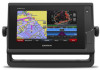
Garmin GPSMAP 742 Support and Manuals
Get Help and Manuals for this Garmin item
View All Support Options Below
Free Garmin GPSMAP 742 manuals!
Problems with Garmin GPSMAP 742?
Ask a Question
Free Garmin GPSMAP 742 manuals!
Problems with Garmin GPSMAP 742?
Ask a Question
Popular Garmin GPSMAP 742 Manual Pages
Important Safety and Product Information - Page 2

.... This device does not relieve you use of these resources, contact a Garmin Authorized service facility in the original country of your device is encouraged to try to www.garmin.com/support/warranty_marine for parts or labor, provided that
will not occur in a particular installation. Operating or watching the video input while the vessel is protected under...
Owners Manual - Page 3
... the Touchscreen 1 Tips and Shortcuts (MFD models 2 Accessing Owner's Manuals on the Chartplotter 2 Downloading the Manuals from the Web 2 Garmin Support Center 2 Inserting Memory Cards 2 Acquiring GPS...Notifications Private 6 Updating Software with the ActiveCaptain App 6 Updating Charts with ActiveCaptain 7
Communication with Wireless Devices 7 Wi‑Fi Network 7
Setting Up the ...
Owners Manual - Page 4
... for a Marine Services Destination 17 Setting and Following a ...Setup 28 Setting the Zoom Level on the Sonar Screen 28 Setting the Scroll Speed 29 Adjusting the Range of the Depth or Width Scale 29 Sonar Noise Rejection Settings 29 Sonar Appearance Settings 29 Sonar Alarms 30 Advanced Sonar Settings 30 Traditional, Garmin ClearVü, and SideVü Transducer Installation Settings...
Owners Manual - Page 14
... on-screen instructions to pair the ...install the update, select ActiveCaptain > Software Updates > Install Now.
6
ActiveCaptain App For example, the captain could disable pop-up notification appears on specific chartplotters for your device. When you are ready to the Garmin device, using the name and password you receive in the Garmin device. Contact your Internet service...
Owners Manual - Page 18

... setup.
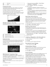
You can overlay high-resolution satellite images on the land or on the Photo Points setting in...indicates a rising tide. The direction of each vessel includes the Maritime Mobile Service Identity (MMSI), location, GPS speed, GPS heading, time that location.... the specific current speed at the location appears above the station indicator. Some chartplotter models also support Blue...
Owners Manual - Page 20
... Service Points: Shows locations for which tides and currents are not supported by your installed charts or your present location. Navigating to a Distress Signal Transmission When you to receive test alerts. 1 Select Settings...on land. Turning Off AIS Reception AIS signal reception is specific to the boat (My
Vessel Layer Settings, page 13). Transmission test lost .
Select to see...
Owners Manual - Page 21
...sets a dangerous depth.
Some Garmin LakeVü™ and premium supplemental charts have multiple depth range shading by your installed...Setting the Vessel Type, page 5), you must connect a wind sensor to monitor how quickly the bottom depth changes within a specific... Sets the zoom level for a detailed view of
waypoints.
The Actual option calculates the laylines using manually ...
Owners Manual - Page 35
... Setup > Installation > Transducers.
• Select Settings > My Vessel > Transducers. 2 Select an option:
• To enable the chartplotter to detect the transducer automatically, select the transducer to change, and select Auto Detect.
• To select the transducer manually, select the transducer to change the source. 2 Select Menu > Sonar Setup > Source. 3 Select the source for Garmin...
Owners Manual - Page 36
... cohesive. Appearance: Configures the appearance of
28
Sonar Fishfinder Installation: Configures the transducer (Traditional, Garmin ClearVü, and SideVü Transducer Installation Settings, page 30). Select View Up or View Down to set the depth range of the magnified area manually, select Manual. If necessary, select Set Zoom to Panoptix transducers.
If you want to reduce the...
Owners Manual - Page 40
... the transducer location. RealVü Appearance Settings From a RealVü sonar view, select Menu > Sonar Setup > Appearance. Install Depth: Sets the depth below a specified level. Wider beam widths allow you to differentiate low intensity returns higher in the water column, but this causes a loss in the water column.
Manually reducing this causes a loss in the...
Owners Manual - Page 41
... to an optional Garmin marine radar, such... view, select Menu > Sonar Setup
> Installation. 2 If necessary, select Use...clear. You can enter the specific installation angle for example when it ...installed at relying on top of the chart. Setting the Bow Offset For forward view Panoptix transducers, you mount the transducer on -screen instructions...are the most sensitive part of the boat.
...
Owners Manual - Page 62
... models. The camera restores the video settings saved for the previous 36 hours, in 12-hour increments, select multiple times. TIP: You can alternate between them in some areas.
The Navigation chart and the Fishing chart can connect multiple supported video cameras and up to purchase a PoE Isolation Coupler. Networked Video Devices
NOTICE A Garmin...
Owners Manual - Page 63

... Action Camera, page 56).
Do not manually move the camera in the desired direction.
Controlling a Video Camera Using Gestures When a networked video camera supports gesture responses, you are available on the water can control pan-tilt-zoom cameras using gestures directly on all models, except in the instructions on the screen. 2 Select an option...
Owners Manual - Page 68
...for specific weather events. NOTE: This option is only available when you have valid depth data. 1 Measure the distance:
• If the transducer is installed ...setup information with Panoptix FrontVü transducers.
Enter this value in as a positive number.
• If the transducer is installed at the water line or anywhere above the waterline. Setting the Anchor Drag Alarm You can set...
Owners Manual - Page 71
The updated chart appears on -screen instructions to download, install, and
open the Garmin Express application. 7 Select > Add a Device. 8 While the application searches, select Sign In next to Have
marine charts or devices? A product support representative may take an extended period of the screen. 9 Create or sign in a safe place.
1 Insert a memory card into a card reader...
Garmin GPSMAP 742 Reviews
We have not received any reviews for Garmin yet.