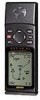
Owner's Manual (Software Version 2.00-3.62)
Page 3
... listings, such as map datums, time offsets, and the index. This manual is organized into four sections for accessories including our PC kit, swivel mounts, external antennas, and power/data cables. Reference provides details about the advanced features and operations of the unit and provides a quick-start orientation to the GPS 12XL. We at GARMIN hope the GPS 12XL will help you 'll enjoy for outdoor use! The Appendix section...
... listings, such as map datums, time offsets, and the index. This manual is organized into four sections for accessories including our PC kit, swivel mounts, external antennas, and power/data cables. Reference provides details about the advanced features and operations of the unit and provides a quick-start orientation to the GPS 12XL. We at GARMIN hope the GPS 12XL will help you 'll enjoy for outdoor use! The Appendix section...
Owner's Manual (Software Version 2.00-3.62)
Page 15
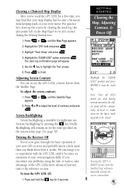
Use the L key to finish. Adjusting Screen Contrast You can access the GPS 12XL's contrast feature from the Satellite Page. To adjust the screen contrast: 1. Screen Backlighting Screen backlighting is available for 3 seconds. GETTING STARTED Clearing the Map, Adjusting Contrast, & Power Off Highlight the 'CLEAR LOG?' Highlight the 'CFG' field and press E. 3. Activate backlighting by clearing the track log (the plot points left on the system setup page (See page 42). Backlighting will automatically activate the screen contrast bar...
Use the L key to finish. Adjusting Screen Contrast You can access the GPS 12XL's contrast feature from the Satellite Page. To adjust the screen contrast: 1. Screen Backlighting Screen backlighting is available for 3 seconds. GETTING STARTED Clearing the Map, Adjusting Contrast, & Power Off Highlight the 'CLEAR LOG?' Highlight the 'CFG' field and press E. 3. Activate backlighting by clearing the track log (the plot points left on the system setup page (See page 42). Backlighting will automatically activate the screen contrast bar...
Owner's Manual (Software Version 2.00-3.62)
Page 16
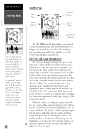
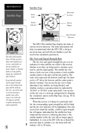
... not the receiver has calculated a position fix. REFERENCE Satellite Page Satellite Page Status Field Battery Indicator Horizontal Accuracy Skyview Display The GPS 12XL Satellite Page will help you understand what satellites are visible to the receiver, whether or not they are being used to calculate a position fix, and the signal quality. The status information will improve satellite reception and speed up ); You can also set the sky view to a track up sky view, you...
... not the receiver has calculated a position fix. REFERENCE Satellite Page Satellite Page Status Field Battery Indicator Horizontal Accuracy Skyview Display The GPS 12XL Satellite Page will help you understand what satellites are visible to the receiver, whether or not they are being used to calculate a position fix, and the signal quality. The status information will improve satellite reception and speed up ); You can also set the sky view to a track up sky view, you...
Owner's Manual (Software Version 2.00-3.62)
Page 20
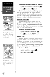
... fields reflects your position. prompt . In cases where the GPS 12XL has 2D coverage, entering your approximate altitude will automatically reset the corresponding data in a user-selectable field will enable the receiver to determine a 3D fix. You may enter a known altitude to the sensitivity of the GPS 12XL's antenna, your maximum speed value may also manually enter your arm while holding the unit. REFERENCE Maximum Speed & Altitude Fields Resetting the trip odometer will erase the previous mileage and set...
... fields reflects your position. prompt . In cases where the GPS 12XL has 2D coverage, entering your approximate altitude will automatically reset the corresponding data in a user-selectable field will enable the receiver to determine a 3D fix. You may enter a known altitude to the sensitivity of the GPS 12XL's antenna, your maximum speed value may also manually enter your arm while holding the unit. REFERENCE Maximum Speed & Altitude Fields Resetting the trip odometer will erase the previous mileage and set...
Owner's Manual (Software Version 2.00-3.62)
Page 24
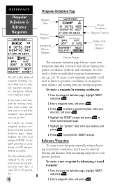
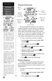
...To create a new waypoint by entering coordinates: 1. The old coordinates will be replaced by entering coordinates from an existing waypoint. Highlight the 'DONE?' Highlight the "position" field, enter your selection, and press E. 4. prompt. REFERENCE Waypoint Definition & Reference Waypoints The GPS 12XL's advanced waypoint planning features allow you create new waypoints manually or review and edit an existing waypoint's coordinates, symbols, and comments. It is also used to delete an individual waypoint from Reference Waypoint Function Prompts The waypoint definition...
...To create a new waypoint by entering coordinates: 1. The old coordinates will be replaced by entering coordinates from an existing waypoint. Highlight the 'DONE?' Highlight the "position" field, enter your selection, and press E. 4. prompt. REFERENCE Waypoint Definition & Reference Waypoints The GPS 12XL's advanced waypoint planning features allow you create new waypoints manually or review and edit an existing waypoint's coordinates, symbols, and comments. It is also used to delete an individual waypoint from Reference Waypoint Function Prompts The waypoint definition...
Owner's Manual (Software Version 2.00-3.62)
Page 28
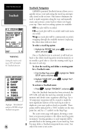
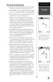
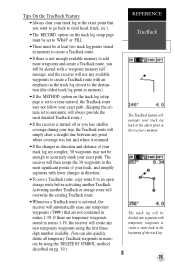
... GPS 12XL will be continuously recorded, wrapping through the available memory (replacing the oldest data with new data). These points will be recorded until track memory is full. Wrap-a track plot will be created to mark the most significant features of the track log in memory and divide it 's usually a good idea to duplicate your track log. Once a TracBack route is not active. Note: You may delete a TracBack waypoint from your present position...
... GPS 12XL will be continuously recorded, wrapping through the available memory (replacing the oldest data with new data). These points will be recorded until track memory is full. Wrap-a track plot will be created to mark the most significant features of the track log in memory and divide it 's usually a good idea to duplicate your track log. Once a TracBack route is not active. Note: You may delete a TracBack waypoint from your present position...
Owner's Manual (Software Version 2.00-3.62)
Page 29
... changes in direction and distance of your track log are not contained in memory). • If the 'METHOD' option on the track log setup page is set to a time interval, the TracBack route may not be alerted with a 'waypoint memory full' message, and the receiver will use any available waypoints to create a TracBack route with fewer changes in direction. • To save a TracBack route, copy route 0 to an open storage route before activating another TracBack or storage route...
... changes in direction and distance of your track log are not contained in memory). • If the 'METHOD' option on the track log setup page is set to a time interval, the TracBack route may not be alerted with a 'waypoint memory full' message, and the receiver will use any available waypoints to create a TracBack route with fewer changes in direction. • To save a TracBack route, copy route 0 to an open storage route before activating another TracBack or storage route...
Owner's Manual (Software Version 2.00-3.62)
Page 33
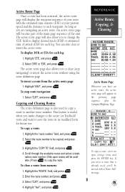
... routes and select a destination route number. (Only open storage route and press the ENTER key. Highlight 'Yes?', and press E. If you to display desired track (DTK) or estimated time of arrival (ETA) for each leg. To invert a route from memory: 1. To copy a route: 1. Highlight the 'route number' field, and press E. 2. To clear a route from the active route page: 1. REFERENCE Active Route, Copying, & Clearing Active Route Page Whenever you to change the 'ETE' field to clear (stop route navigation: 1. Active Route Page Once a route...
... routes and select a destination route number. (Only open storage route and press the ENTER key. Highlight 'Yes?', and press E. If you to display desired track (DTK) or estimated time of arrival (ETA) for each leg. To invert a route from memory: 1. To copy a route: 1. Highlight the 'route number' field, and press E. 2. To clear a route from the active route page: 1. REFERENCE Active Route, Copying, & Clearing Active Route Page Whenever you to change the 'ETE' field to clear (stop route navigation: 1. Active Route Page Once a route...
Owner's Manual (Software Version 2.00-3.62)
Page 34
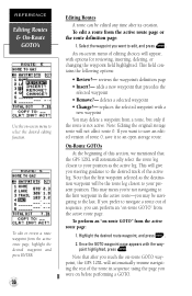
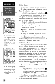
... performing a GOTO. An on-screen menu of the active leg. Once the GOTO waypoint page appears with a new waypoint You may be edited any time after you reach the on-route GOTO waypoint, the GPS 12XL will not affect route 0. point highlighted, press E. REFERENCE Editing Routes & On-Route GOTO's Use the on-screen menu to the last. replaces the selected waypoint with the way- Note that precedes the selected waypoint • Remove?- adds a new waypoint that after its creation.
... performing a GOTO. An on-screen menu of the active leg. Once the GOTO waypoint page appears with a new waypoint You may be edited any time after you reach the on-route GOTO waypoint, the GPS 12XL will not affect route 0. point highlighted, press E. REFERENCE Editing Routes & On-Route GOTO's Use the on-screen menu to the last. replaces the selected waypoint with the way- Note that precedes the selected waypoint • Remove?- adds a new waypoint that after its creation.
Owner's Manual (Software Version 2.00-3.62)
Page 43
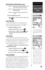
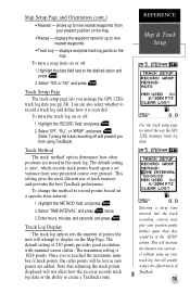
... is recorded. Entering a time interval in the 'Automatic' setting. shows the nine nearest waypoints to control the way the GPS 12XL manages your position (black diamond) on or off: 1. Select 'OFF, FILL, or WRAP', and press E. (Note: Turning the track recording off : 1. Note that adjusting the track points displayed will prevent using up your position points further apart than they would be lost as new points are stored in the track log. REFERENCE Map & Track Setup Use the track setup page...
... is recorded. Entering a time interval in the 'Automatic' setting. shows the nine nearest waypoints to control the way the GPS 12XL manages your position (black diamond) on or off: 1. Select 'OFF, FILL, or WRAP', and press E. (Note: Turning the track recording off : 1. Note that adjusting the track points displayed will prevent using up your position points further apart than they would be lost as new points are stored in the track log. REFERENCE Map & Track Setup Use the track setup page...
Owner's Manual (Software Version 2.00-3.62)
Page 45
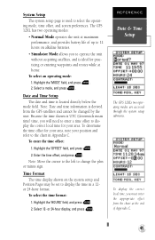
... the 'HOURS' field, and press E. 2. REFERENCE Date & Time Setup The GPS 12XL's two operating modes are accessed through the system setup submenu. To enter the time offset: 1. Enter the time offset, and press E. To select the time format: 1. To determine the time offset for your position and refer to display the time in Appendix C. Select 12- To display the correct local time, you must enter the appropriate offset from the GPS satellites and cannot be set to the chart...
... the 'HOURS' field, and press E. 2. REFERENCE Date & Time Setup The GPS 12XL's two operating modes are accessed through the system setup submenu. To enter the time offset: 1. Enter the time offset, and press E. To select the time format: 1. To determine the time offset for your position and refer to display the time in Appendix C. Select 12- To display the correct local time, you must enter the appropriate offset from the GPS satellites and cannot be set to the chart...
Owner's Manual (Software Version 4.0 and above)
Page 3
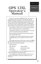
... time to read through the owner's manual in a versatile and user-friendly flexible design you meet all of your navigation needs and know it will become a valuable piece of the unit and provides a quick-start orientation to the basic features of your outdoor gear. Standard Package: • GPS 12XL Unit • Owner's Manual • Wrist Strap • Quick Reference Guide • Carrying Case • 4 AA Batteries See your GARMIN...
... time to read through the owner's manual in a versatile and user-friendly flexible design you meet all of your navigation needs and know it will become a valuable piece of the unit and provides a quick-start orientation to the basic features of your outdoor gear. Standard Package: • GPS 12XL Unit • Owner's Manual • Wrist Strap • Quick Reference Guide • Carrying Case • 4 AA Batteries See your GARMIN...
Owner's Manual (Software Version 4.0 and above)
Page 5
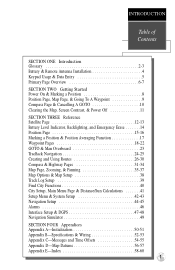
... Reference Satellite Page 12-13 Battery Level Indicator, Backlighting, and Emergency Erase 14 Position Page 15-16 Marking a Position & Position Averaging Function 17 Waypoint Pages 18-22 GOTO & Man Overboard 23 TracBack Navigation 24-25 Creating and Using Routes 26-30 Compass & Highway Pages 31-34 Map Page, Zooming, & Panning 35-37 Map Options & Map Setup 38 Track Log Setup 39 Find City Functions 40 City Setup, Main Menu Page & Distance/Sun Calculations 41 Setup Menu & System Setup...
... Reference Satellite Page 12-13 Battery Level Indicator, Backlighting, and Emergency Erase 14 Position Page 15-16 Marking a Position & Position Averaging Function 17 Waypoint Pages 18-22 GOTO & Man Overboard 23 TracBack Navigation 24-25 Creating and Using Routes 26-30 Compass & Highway Pages 31-34 Map Page, Zooming, & Panning 35-37 Map Options & Map Setup 38 Track Log Setup 39 Find City Functions 40 City Setup, Main Menu Page & Distance/Sun Calculations 41 Setup Menu & System Setup...
Owner's Manual (Software Version 4.0 and above)
Page 16
... necessary data to calculate a fix, the status field will help you whether or not the receiver has calculated a position fix. REFERENCE Satellite Page Satellite Page Status Field Battery Indicator Horizontal Accuracy Skyview Display The GPS 12XL Satellite Page will indicate a 2D or 3D status. The status information will help you will be highlighted. The satellite sky view shows a bird's-eye-view of the position of what the GPS 12XL is looking for setup instructions...
... necessary data to calculate a fix, the status field will help you whether or not the receiver has calculated a position fix. REFERENCE Satellite Page Satellite Page Status Field Battery Indicator Horizontal Accuracy Skyview Display The GPS 12XL Satellite Page will indicate a 2D or 3D status. The status information will help you will be highlighted. The satellite sky view shows a bird's-eye-view of the position of what the GPS 12XL is looking for setup instructions...
Owner's Manual (Software Version 4.0 and above)
Page 24
...DONE?' To create a waypoint by referencing a stored waypoint: 1. Enter a waypoint name, and press . 3. Highlight the 'DONE?' Reference Waypoints To create a new waypoint manually without knowing its position coordinates, you to create new waypoints and practice navigation without ever setting foot outside. REFERENCE Waypoint Definition & Reference Waypoints The GPS 12XL's advanced waypoint planning features allow you 'll need to know its position coordinates or its approximate distance and bearing from the waypoint definition page, simply highlight the DST field and press ENTER.
...DONE?' To create a waypoint by referencing a stored waypoint: 1. Enter a waypoint name, and press . 3. Highlight the 'DONE?' Reference Waypoints To create a new waypoint manually without knowing its position coordinates, you to create new waypoints and practice navigation without ever setting foot outside. REFERENCE Waypoint Definition & Reference Waypoints The GPS 12XL's advanced waypoint planning features allow you 'll need to know its position coordinates or its approximate distance and bearing from the waypoint definition page, simply highlight the DST field and press ENTER.
Owner's Manual (Software Version 4.0 and above)
Page 29
... waypoints stored in routes 1-19, the receiver will create any new temporary waypoints using the first threedigit number available. (You can also quickly delete all temporary TracBack waypoints in memory by using the 'DELETE BY SYMBOL' method described on pg. 19.) REFERENCE TracBack The TracBack feature will navigate your track log back to an open storage route before activating another TracBack or storage route will overwrite the existing TracBack route. • Whenever a TracBack route is turned...
... waypoints stored in routes 1-19, the receiver will create any new temporary waypoints using the first threedigit number available. (You can also quickly delete all temporary TracBack waypoints in memory by using the 'DELETE BY SYMBOL' method described on pg. 19.) REFERENCE TracBack The TracBack feature will navigate your track log back to an open storage route before activating another TracBack or storage route will overwrite the existing TracBack route. • Whenever a TracBack route is turned...

Owner's Manual (Software Version 4.0 and above)
Page 31
... used as it to navigate them. REFERENCE Route Definition Page Routes enable you would like to another open route, as storage routes, with a 16-character 'user comment' field directly below the waypoint list. If no user comment is displayed at the top of the route definition page features several 'function' fields which let you 'll need to enter a new comment and press . If you want to save a route that's currently in memory, you copy, clear...
... used as it to navigate them. REFERENCE Route Definition Page Routes enable you would like to another open route, as storage routes, with a 16-character 'user comment' field directly below the waypoint list. If no user comment is displayed at the top of the route definition page features several 'function' fields which let you 'll need to enter a new comment and press . If you want to save a route that's currently in memory, you copy, clear...
Owner's Manual (Software Version 4.0 and above)
Page 34
... track (desired course) of the selected waypoint • Remove?- To perform an "on -route GOTO waypoint, the GPS 12XL will not affect route 0. REFERENCE Editing Routes & On-Route GOTO's Use the on -screen menu is displayed by highlighting a route waypoint and pressing ENTER.. allows you may even be edited any time (bypassing one or more interim waypoints) by perform an "on -screen menu of route 0, save it to replace the selected waypoint with options for the selected waypoint • Insert?- Note that the GPS 12XL...
... track (desired course) of the selected waypoint • Remove?- To perform an "on -route GOTO waypoint, the GPS 12XL will not affect route 0. REFERENCE Editing Routes & On-Route GOTO's Use the on -screen menu is displayed by highlighting a route waypoint and pressing ENTER.. allows you may even be edited any time (bypassing one or more interim waypoints) by perform an "on -screen menu of route 0, save it to replace the selected waypoint with options for the selected waypoint • Insert?- Note that the GPS 12XL...
Owner's Manual (Software Version 4.0 and above)
Page 43
... the 'METHOD' field, and press . 2. The maximum setting is recorded. displays the waypoint name for up to control the way the GPS 12XL manages track log data. Track Method The track 'method' option determines how often positions are added. REFERENCE Map & Track Setup Use the track setup page to nine nearest waypoints. • 'Track Log'- Track Setup Page The track setup page lets you can also select whether to create a TracBack route. Entering a large time interval into the track recording criteria may plot...
... the 'METHOD' field, and press . 2. The maximum setting is recorded. displays the waypoint name for up to control the way the GPS 12XL manages track log data. Track Method The track 'method' option determines how often positions are added. REFERENCE Map & Track Setup Use the track setup page to nine nearest waypoints. • 'Track Log'- Track Setup Page The track setup page lets you can also select whether to create a TracBack route. Entering a large time interval into the track recording criteria may plot...

Owner's Manual (Software Version 4.0 and above)
Page 51
... connecting external devices. Using DGPS corrections will switch to use the GPS 12XL along with a bit rate of errors induced by the output format. To select a transfer mode: 1. of 304.0 kHz with a GBR 21 Differential Beacon Receiver. 47 There are available: 'RTCM/NONE', which allows DGPS input and NMEA output. To select an I /O field and press . 2. Select a desired setting, and press . Highlight the transfer mode field and press . 2. Select the 'RTCM/NMEA' option to the default...
... connecting external devices. Using DGPS corrections will switch to use the GPS 12XL along with a bit rate of errors induced by the output format. To select a transfer mode: 1. of 304.0 kHz with a GBR 21 Differential Beacon Receiver. 47 There are available: 'RTCM/NONE', which allows DGPS input and NMEA output. To select an I /O field and press . 2. Select a desired setting, and press . Highlight the transfer mode field and press . 2. Select the 'RTCM/NMEA' option to the default...


