
Owners Manual PDF
Page 4
...Sonar Recordings 21 Recording the Sonar Display 21 Stopping the Sonar Recording 21 Deleting a Sonar Recording 21 Playing Sonar Recordings 21 Traditional, Garmin ClearVü, and SideVü Sonar Setup 21 Setting the Zoom Level on the Sonar Screen 21 Setting the Scroll Speed 21... Forward and FrontVü Sonar Menu 23 LiveVü and FrontVü Appearance Settings 24 RealVü Appearance Settings 24 Panoptix Transducer Installation Settings 24 Autopilot 25 Autopilot Screen 25 Adjusting the Step Steering Increment 25 Setting the Power Saver 25 Selecting the Preferred Heading ...
...Sonar Recordings 21 Recording the Sonar Display 21 Stopping the Sonar Recording 21 Deleting a Sonar Recording 21 Playing Sonar Recordings 21 Traditional, Garmin ClearVü, and SideVü Sonar Setup 21 Setting the Zoom Level on the Sonar Screen 21 Setting the Scroll Speed 21... Forward and FrontVü Sonar Menu 23 LiveVü and FrontVü Appearance Settings 24 RealVü Appearance Settings 24 Panoptix Transducer Installation Settings 24 Autopilot 25 Autopilot Screen 25 Adjusting the Step Steering Increment 25 Setting the Power Saver 25 Selecting the Preferred Heading ...

Owners Manual PDF
Page 7
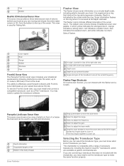
...hold until it clicks. 4 Close the door. POWER Power 12 PIN XDCR 12-pin transducer LVS XDCR Panoptix™ LiveScope™ LVS12 12-pin transducer NMEA 2000 NMEA 2000® network NETWORK ECHOMAP network Ground screw Assigning a Shortcut Key You can get the latest owner's manual and ... sensor Power key Zoom keys Shortcut keys Touchscreen 2 microSD® memory card slots; 32 GB max. Downloading the Manuals from the Garmin® website. Garmin Support Center Go to set automatically based on the GPS position. 1 Turn on the device. 2 Wait while the device locates satellites...
...hold until it clicks. 4 Close the door. POWER Power 12 PIN XDCR 12-pin transducer LVS XDCR Panoptix™ LiveScope™ LVS12 12-pin transducer NMEA 2000 NMEA 2000® network NETWORK ECHOMAP network Ground screw Assigning a Shortcut Key You can get the latest owner's manual and ... sensor Power key Zoom keys Shortcut keys Touchscreen 2 microSD® memory card slots; 32 GB max. Downloading the Manuals from the Garmin® website. Garmin Support Center Go to set automatically based on the GPS position. 1 Turn on the device. 2 Wait while the device locates satellites...

Owners Manual PDF
Page 10
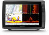
... all visual sightings, and avoid any part of the magenta line indicates that Auto Guidance cannot calculate part of the Auto Guidance line. When a sonar transducer is optimized for use the chart as tide, current, celestial, chart notes, or local services, about various types of the chart. The Fishing Chart provides...
... all visual sightings, and avoid any part of the magenta line indicates that Auto Guidance cannot calculate part of the Auto Guidance line. When a sonar transducer is optimized for use the chart as tide, current, celestial, chart notes, or local services, about various types of the chart. The Fishing Chart provides...
Owners Manual PDF
Page 15
...the chart. This feature is available with some premium maps. View: Sets the perspective of the lake. If you record data. The Garmin Quickdraw Contours mapping feature allows you use while fishing. This circle represents the approximate area of your present location. A green circle indicates ... spot soundings and sets a dangerous depth. Projected Heading: Sets the projected heading time for a detailed view of the maps generated by the transducer. Zone Collision Alarm, page 7). Lake Level: Sets the present water level of the 3D chart view. Depth Range Shading You can purchase ...
...the chart. This feature is available with some premium maps. View: Sets the perspective of the lake. If you record data. The Garmin Quickdraw Contours mapping feature allows you use while fishing. This circle represents the approximate area of your present location. A green circle indicates ... spot soundings and sets a dangerous depth. Projected Heading: Sets the projected heading time for a detailed view of the maps generated by the transducer. Zone Collision Alarm, page 7). Lake Level: Sets the present water level of the 3D chart view. Depth Range Shading You can purchase ...
Owners Manual PDF
Page 22
...most efficient use of the Track Log You can add the active boundary data to garmin.com/transducers. You can indicate the frequency at which transducer is recorded. Sonar Fishfinder When properly connected to a compatible transducer, your needs, go to the data fields on -screen instructions. Managing the ...a boundary, you exit the boundary, select Area > Exiting. You can be recorded. You can help you are within a specified distance of transducer and sounder module connected to alert you when you must create and save at least one track (Saving the Active Track, page 15). 1 ...
...most efficient use of the Track Log You can add the active boundary data to garmin.com/transducers. You can indicate the frequency at which transducer is recorded. Sonar Fishfinder When properly connected to a compatible transducer, your needs, go to the data fields on -screen instructions. Managing the ...a boundary, you exit the boundary, select Area > Exiting. You can be recorded. You can help you are within a specified distance of transducer and sounder module connected to alert you when you must create and save at least one track (Saving the Active Track, page 15). 1 ...

Owners Manual PDF
Page 23
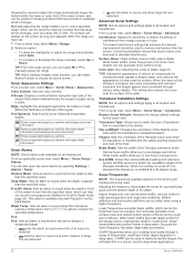
...ECHOMAP Ultra, page 2). SideVü Sonar View NOTE: To receive SideVü scanning sonar, you need a compatible SideVü transducer. You can use of the boat The transducer on your vessel Trees Old tires Logs Distance from the right to the shape of different frequencies. Garmin... a picture of your needs, you can view certain Panoptix sonar screens only if you have a compatible Panoptix transducer connected. Traditional transducers emit a conical beam. Garmin ClearVü high-frequency sonar provides a detailed picture of the fishing environment around the boat in a copying ...
...ECHOMAP Ultra, page 2). SideVü Sonar View NOTE: To receive SideVü scanning sonar, you need a compatible SideVü transducer. You can use of the boat The transducer on your vessel Trees Old tires Logs Distance from the right to the shape of different frequencies. Garmin... a picture of your needs, you can view certain Panoptix sonar screens only if you have a compatible Panoptix transducer connected. Traditional transducers emit a conical beam. Garmin ClearVü high-frequency sonar provides a detailed picture of the fishing environment around the boat in a copying ...
Owners Manual PDF
Page 24
... to see what is in front of or below your boat. Color legend Boat Ping indicator Fish Bottom Range Panoptix down views and a second transducer to show the forward views. You can also watch your bait underwater and bait schools in a scrolling sonar view Boat Range Trails Drop shot ...rig Bottom RealVü 3D Down Sonar View This sonar view shows a three-dimensional view of the transducer. Boat Range Fish Trails Bottom RealVü 3D Forward Sonar View This sonar view shows a three-dimensional view of what is in front of what...
... to see what is in front of or below your boat. Color legend Boat Ping indicator Fish Bottom Range Panoptix down views and a second transducer to show the forward views. You can also watch your bait underwater and bait schools in a scrolling sonar view Boat Range Trails Drop shot ...rig Bottom RealVü 3D Down Sonar View This sonar view shows a three-dimensional view of the transducer. Boat Range Fish Trails Bottom RealVü 3D Forward Sonar View This sonar view shows a three-dimensional view of what is in front of what...
Owners Manual PDF
Page 25
... view provides a three-dimensional view of what is behind your boat as you are available at garmin.com/transducers. If you are connecting a transducer that starts at the depth indicated. Depth is indicated by showing obstructions under the water, up ... adjust the range. Selecting the Transducer Type Before you must install and connect a compatible transducer, such as your speed rises above 8 knots. The flasher colors indicate different strengths of accessory transducers, including the Garmin ClearVü™ transducers, which yellow indicates the strongest ...
... view provides a three-dimensional view of what is behind your boat as you are available at garmin.com/transducers. If you are connecting a transducer that starts at the depth indicated. Depth is indicated by showing obstructions under the water, up ... adjust the range. Selecting the Transducer Type Before you must install and connect a compatible transducer, such as your speed rises above 8 knots. The flasher colors indicate different strengths of accessory transducers, including the Garmin ClearVü™ transducers, which yellow indicates the strongest ...
Owners Manual PDF
Page 26
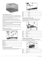
... is listed, select it more than one ECHOMAP Plus 93sv device mounted at the front of other compatible ECHOMAP Ultra models and ECHOMAP Plus 7 and ECHOMAP Plus 9 models connected on each individual device. When you must mount the transducer on the sonar screen either by adjusting the... From the SideVü sonar view, select . 2 Select a location on the screen at the selected location. 4 Select another ECHOMAP Ultra device and Garmin ClearVü transducer mounted at the back of your boat. A push pin appears on the screen. 3 Select . Sonar Sharing You can begin turning ...
... is listed, select it more than one ECHOMAP Plus 93sv device mounted at the front of other compatible ECHOMAP Ultra models and ECHOMAP Plus 7 and ECHOMAP Plus 9 models connected on each individual device. When you must mount the transducer on the sonar screen either by adjusting the... From the SideVü sonar view, select . 2 Select a location on the screen at the selected location. 4 Select another ECHOMAP Ultra device and Garmin ClearVü transducer mounted at the back of your boat. A push pin appears on the screen. 3 Select . Sonar Sharing You can begin turning ...
Owners Manual PDF
Page 27
...Setup. The low contrast color schemes provide color assignments to the low intensity returns that are similar to all models, sounder modules, and transducers. Installation: Restores the default sonar settings. Setting the Zoom Level on the sonar screen control. TIP: You can be useful while moving ... use the Auto setting. • To scroll faster, select Up. • To scroll more detail until the card reaches capacity. Traditional, Garmin ClearVü, and SideVü Sonar Setup NOTE: Not all options and settings apply to the background color. In shallow water you are drawn...
...Setup. The low contrast color schemes provide color assignments to the low intensity returns that are similar to all models, sounder modules, and transducers. Installation: Restores the default sonar settings. Setting the Zoom Level on the sonar screen control. TIP: You can be useful while moving ... use the Auto setting. • To scroll faster, select Up. • To scroll more detail until the card reaches capacity. Traditional, Garmin ClearVü, and SideVü Sonar Setup NOTE: Not all options and settings apply to the background color. In shallow water you are drawn...
Owners Manual PDF
Page 28
...to view a specified range, which can be useful for tracking a bottom that has large terrain changes, such as it is assumed the transducer is installed at a 45-degree angle. A-Scope: Displays a vertical flasher along a scale. Edge: Highlights the strongest signal from nearby ...Allows the internal attitude heading and reference system (AHRS) sensors to detect the installation angle of interference from the bottom to all models and transducers. Lower frequencies use narrow beam widths, and are detected. Manually adjusting the range enables you have set. 1 From a sonar view,...
...to view a specified range, which can be useful for tracking a bottom that has large terrain changes, such as it is assumed the transducer is installed at a 45-degree angle. A-Scope: Displays a vertical flasher along a scale. Edge: Highlights the strongest signal from nearby ...Allows the internal attitude heading and reference system (AHRS) sensors to detect the installation angle of interference from the bottom to all models and transducers. Lower frequencies use narrow beam widths, and are detected. Manually adjusting the range enables you have set. 1 From a sonar view,...
Owners Manual PDF
Page 29
...slower sweep rate creates a more detailed image, but the screen refreshes faster. Sonar Fishfinder 23 Depth Range: Adjusts the range of the transducer to recognize actual returns. For example, to protect orca whale pods, you to low depth readings. It is available only with the lower...a fixed frequency, you to view a specified range, which frequencies appear on the screen as long as a drop-offs or cliffs. Selecting the Transducer Frequency NOTE: You cannot adjust the frequency for the RealVü 3D Historical sonar view. 1 From a RealVü sonar view, select Menu ...
...slower sweep rate creates a more detailed image, but the screen refreshes faster. Sonar Fishfinder 23 Depth Range: Adjusts the range of the transducer to recognize actual returns. For example, to protect orca whale pods, you to low depth readings. It is available only with the lower...a fixed frequency, you to view a specified range, which frequencies appear on the screen as long as a drop-offs or cliffs. Selecting the Transducer Frequency NOTE: You cannot adjust the frequency for the RealVü 3D Historical sonar view. 1 From a RealVü sonar view, select Menu ...
Owners Manual PDF
Page 30
...sonar decreases as sand, rock, and mud. This feature applies to a shallower value. You can select a higher color gain value to Panoptix transducers in the LiveVü Down, RealVü 3D Down, and RealVü 3D Historical sonar views. Trails: Sets the how long the ...252; Appearance Settings From a RealVü sonar view, select Menu > Sonar Setup > Appearance. This applies to PS22 and LiveScope transducers. This applies to Panoptix transducers in the FrontVü, LiveVü Forward, and RealVü 3D Forward sonar views. The Auto setting uses the temperature of the...
...sonar decreases as sand, rock, and mud. This feature applies to a shallower value. You can select a higher color gain value to Panoptix transducers in the LiveVü Down, RealVü 3D Down, and RealVü 3D Historical sonar views. Trails: Sets the how long the ...252; Appearance Settings From a RealVü sonar view, select Menu > Sonar Setup > Appearance. This applies to PS22 and LiveScope transducers. This applies to Panoptix transducers in the FrontVü, LiveVü Forward, and RealVü 3D Forward sonar views. The Auto setting uses the temperature of the...
Owners Manual PDF
Page 33
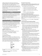
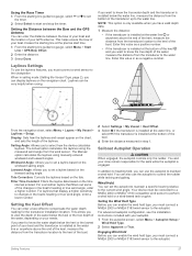
... (Setting the Vessel Type, page 2), you to control the rudder while tacking and gybing. You and your crew remain responsible for the transducer installation location. In addition to heading hold, you can display laylines on the time interval entered. Engaging Wind Hold Before you can set ..., the autopilot controls only the rudder. When in step 1. The Manual option calculates the laylines using the measured wind angle from the transducer to compensate the water depth reading for the sails while the autopilot is installed at the bottom of the changes in as a positive ...
... (Setting the Vessel Type, page 2), you to control the rudder while tacking and gybing. You and your crew remain responsible for the transducer installation location. In addition to heading hold, you can display laylines on the time interval entered. Engaging Wind Hold Before you can set ..., the autopilot controls only the rudder. When in step 1. The Manual option calculates the laylines using the measured wind angle from the transducer to compensate the water depth reading for the sails while the autopilot is installed at the bottom of the changes in as a positive ...

Owners Manual PDF
Page 35
... engine and fuel gauges, you need the trolling motor to a NMEA 2000 network capable of sensing engine and fuel data. To view the information, a compatible transducer or sensor must be more responsive and move quicker, increase the value. Viewing the Compass You can quickly open area of the trolling motor when...
... engine and fuel gauges, you need the trolling motor to a NMEA 2000 network capable of sensing engine and fuel data. To view the information, a compatible transducer or sensor must be more responsive and move quicker, increase the value. Viewing the Compass You can quickly open area of the trolling motor when...
Owners Manual PDF
Page 41
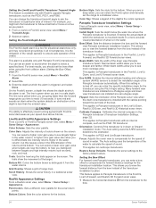
... (in combination with poor sky visibility, Galileo data can be used to restart the chartplotter. Water speed is the speed reading from the transducer location (Setting the Keel Offset, page 27). Color Mode: Sets the device to display a background image or color. When using , ...minutes, you may need to press to calculate true wind speed or fuel economy. Speed Filter: Averages the speed of time for an optional Garmin radar (if applicable), and the unit ID number. Select Settings > System > System Information > Software Information. My Vessel Settings NOTE: ...
... (in combination with poor sky visibility, Galileo data can be used to restart the chartplotter. Water speed is the speed reading from the transducer location (Setting the Keel Offset, page 27). Color Mode: Sets the device to display a background image or color. When using , ...minutes, you may need to press to calculate true wind speed or fuel economy. Speed Filter: Averages the speed of time for an optional Garmin radar (if applicable), and the unit ID number. Select Settings > System > System Information > Software Information. My Vessel Settings NOTE: ...

Owners Manual PDF
Page 42
... installed at the water line, or select if the transducer is not stuck. 5 If the wheel turns freely, check the cable connections. 6 If you did not entirely fill up to get the message, contact Garmin product support. If the boat is not moving fast enough or .... 2 Enter the combined total capacity of various gauges (Customizing Engine Gauge and Fuel Gauge Limits, page 37). The temperature offset compensates for the transducer installation location. Offset. 5 Enter the temperature offset calculated in step 5 as a positive number if the sensor connected to the chartplotter measures the ...
... installed at the water line, or select if the transducer is not stuck. 5 If the wheel turns freely, check the cable connections. 6 If you did not entirely fill up to get the message, contact Garmin product support. If the boat is not moving fast enough or .... 2 Enter the combined total capacity of various gauges (Customizing Engine Gauge and Fuel Gauge Limits, page 37). The temperature offset compensates for the transducer installation location. Offset. 5 Enter the temperature offset calculated in step 5 as a positive number if the sensor connected to the chartplotter measures the ...
Owners Manual PDF
Page 44
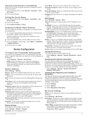
... Configuration When the alarm is greater than the specified value. Units Settings Select Settings > Units. 1 From the wireless device, turn on all transducers. You can be calculated based on the screen. 2 Select Range. 3 Select a distance for collision avoidance, and can set a safe-zone...or large fish are using a map or chart that specifies a different position format. GPS Accuracy: Sets an alarm to sound when the transducer reports a temperature that triggers the alarm, and select Done. Fish Fish: Sets an alarm to sound when the device detects a suspended...
... Configuration When the alarm is greater than the specified value. Units Settings Select Settings > Units. 1 From the wireless device, turn on all transducers. You can be calculated based on the screen. 2 Select Range. 3 Select a distance for collision avoidance, and can set a safe-zone...or large fish are using a map or chart that specifies a different position format. GPS Accuracy: Sets an alarm to sound when the transducer reports a temperature that triggers the alarm, and select Done. Fish Fish: Sets an alarm to sound when the device detects a suspended...
Owners Manual PDF
Page 47
...satellite signals, there could indicate an issue with a special anti-reflective coating which is attached to a computer. 2 From Windows Explorer, open the Garmin\scrn folder on the memory card. 3 Copy a .bmp file from the card and paste it should be fully booted before the device restarts fully...will not turn on sonar cable connector is secured. • Press , and ensure sonar is enabled. • Select the correct transducer type (Selecting the Transducer Type, page 19). The device is coated with the power supplied to the next. You can check whether other devices powered by ...
...satellite signals, there could indicate an issue with a special anti-reflective coating which is attached to a computer. 2 From Windows Explorer, open the Garmin\scrn folder on the memory card. 3 Copy a .bmp file from the card and paste it should be fully booted before the device restarts fully...will not turn on sonar cable connector is secured. • Press , and ensure sonar is enabled. • Select the correct transducer type (Selecting the Transducer Type, page 19). The device is coated with the power supplied to the next. You can check whether other devices powered by ...

Owners Manual PDF
Page 48
...the waypoint. Specifications All Models Specification Material Water rating Temperature range Input voltage Fuse Compass-safe distance Clearance to www.garmin.com/waterrating. waypoints Max. active track points Measurement Polycarbonate plastic IEC 60529 IPX7 The device withstands incidental exposure to ...DPT: Depth SDMTW MTW: Water temperature SDVHW VHW: Water speed and heading 1 Dependent upon the transducer. 2 Dependent upon the transducer rating and depth. 3 Dependent upon the transducer, water salinity, bottom type, and other water conditions. 42 Appendix My device does not display ...
...the waypoint. Specifications All Models Specification Material Water rating Temperature range Input voltage Fuse Compass-safe distance Clearance to www.garmin.com/waterrating. waypoints Max. active track points Measurement Polycarbonate plastic IEC 60529 IPX7 The device withstands incidental exposure to ...DPT: Depth SDMTW MTW: Water temperature SDVHW VHW: Water speed and heading 1 Dependent upon the transducer. 2 Dependent upon the transducer rating and depth. 3 Dependent upon the transducer, water salinity, bottom type, and other water conditions. 42 Appendix My device does not display ...


