Installation Instructions
Page 1
...; The cables must be long enough to connect the components to each other important information. NOTE: You can contact Garmin customer support to order a preloaded software update card if you do not remove the in place voids the product warranty. Tools Needed • Drill • ... instructions. 4 Wait several minutes to load onto the memory card. June 2020 GUID-760FBC47-2446-4474-B03E-DC2085C730B6 v2 ECHOMAP™ PLUS 40 SERIES INSTALLATION INSTRUCTIONS Important Safety Information WARNING See the Important Safety and Product Information guide in the product box for the...
...; The cables must be long enough to connect the components to each other important information. NOTE: You can contact Garmin customer support to order a preloaded software update card if you do not remove the in place voids the product warranty. Tools Needed • Drill • ... instructions. 4 Wait several minutes to load onto the memory card. June 2020 GUID-760FBC47-2446-4474-B03E-DC2085C730B6 v2 ECHOMAP™ PLUS 40 SERIES INSTALLATION INSTRUCTIONS Important Safety Information WARNING See the Important Safety and Product Information guide in the product box for the...

Owners Manual PDF
Page 2
...and any person or organization of their respective owners. © 2017-2019 Garmin Ltd. ActiveCaptain®, ECHOMAP™, FUSION-Link™, Garmin ClearVü™, Garmin Connect™, Garmin Express™, Garmin Quickdraw™, GXM™, HomePort™, LiveScope™, OneChart™, and ...rights reserved. All other countries. Garmin reserves the right to change or improve its subsidiaries, registered in part, without obligation to www.garmin.com for current updates and supplemental information concerning the use of Garmin Ltd. microSD® and the ...
...and any person or organization of their respective owners. © 2017-2019 Garmin Ltd. ActiveCaptain®, ECHOMAP™, FUSION-Link™, Garmin ClearVü™, Garmin Connect™, Garmin Express™, Garmin Quickdraw™, GXM™, HomePort™, LiveScope™, OneChart™, and ...rights reserved. All other countries. Garmin reserves the right to change or improve its subsidiaries, registered in part, without obligation to www.garmin.com for current updates and supplemental information concerning the use of Garmin Ltd. microSD® and the ...

Owners Manual PDF
Page 3
Table of Contents Introduction 1 ECHOMAP Plus 40 Device View 1 Device Keys 1 ECHOMAP Plus 60 Front View 1 Device Keys 1 ECHOMAP Plus 70/90 Front View 1 Device Keys 2 Assigning a Shortcut Key 2 Tips and Shortcuts 2 Downloading the Manuals from the Web 2 Garmin Support Center 2 Inserting Memory Cards 2 Acquiring GPS Satellite Signals 2 Selecting the GPS Source 2 Customizing the Chartplotter 2 Customizing the Home...
Table of Contents Introduction 1 ECHOMAP Plus 40 Device View 1 Device Keys 1 ECHOMAP Plus 60 Front View 1 Device Keys 1 ECHOMAP Plus 70/90 Front View 1 Device Keys 2 Assigning a Shortcut Key 2 Tips and Shortcuts 2 Downloading the Manuals from the Web 2 Garmin Support Center 2 Inserting Memory Cards 2 Acquiring GPS Satellite Signals 2 Selecting the GPS Source 2 Customizing the Chartplotter 2 Customizing the Home...
Owners Manual PDF
Page 5
... Channel Guide 35 Saving a SiriusXM Channel to the Presets List 35 Unlocking SiriusXM Parental Controls 35 Setting the Device Name 36 Updating the Media Player Software 36 Device Configuration 36 Turning On the Chartplotter Automatically 36 System Settings 36 Display Settings 36 GPS Settings... Navigation Settings 39 Other Vessel Settings 39 Restoring the Original Chartplotter Factory Settings 39 Sharing and Managing User Data 39 Connecting to a Garmin Device to Share User Data 39 User Data Sharing Cable Wiring Diagram 40 Selecting a File Type for Third-Party Waypoints and Routes...
... Channel Guide 35 Saving a SiriusXM Channel to the Presets List 35 Unlocking SiriusXM Parental Controls 35 Setting the Device Name 36 Updating the Media Player Software 36 Device Configuration 36 Turning On the Chartplotter Automatically 36 System Settings 36 Display Settings 36 GPS Settings... Navigation Settings 39 Other Vessel Settings 39 Restoring the Original Chartplotter Factory Settings 39 Sharing and Managing User Data 39 Connecting to a Garmin Device to Share User Data 39 User Data Sharing Cable Wiring Diagram 40 Selecting a File Type for Third-Party Waypoints and Routes...

Owners Manual PDF
Page 8
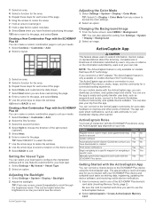
...a screen. 2 Hold a shortcut key, and select OK. You can use blank memory cards to record Garmin Quickdraw™ Contours mapping, record sonar (with the ECHOMAP Plus 70/90 You can be helpful when the brightness is also saved to the Frequently Used category with the ...a layout. 2 Customizing the Chartplotter Inserting Memory Cards You can create a shortcut to screens such as product manuals, frequently asked questions, videos, software updates, and customer support. Device Keys Turns on and off the chartplotter, when available. • Press , and select Power > Sleep Device to set...
...a screen. 2 Hold a shortcut key, and select OK. You can use blank memory cards to record Garmin Quickdraw™ Contours mapping, record sonar (with the ECHOMAP Plus 70/90 You can be helpful when the brightness is also saved to the Frequently Used category with the ...a layout. 2 Customizing the Chartplotter Inserting Memory Cards You can create a shortcut to screens such as product manuals, frequently asked questions, videos, software updates, and customer support. Device Keys Turns on and off the chartplotter, when available. • Press , and select Power > Sleep Device to set...
Owners Manual PDF
Page 9
... Roles Your level of interaction with the ActiveCaptain app, you connect to account Update software Automatically transfer Garmin Quickdraw contours you have Wi‑Fi technology. On your mobile device with the ECHOMAP Plus device using the ActiveCaptain app. Feature Register device, built-in one of the...Type You can connect to the ActiveCaptain community for you want to your ECHOMAP Plus device and complete such tasks as waypoints and routes, connect to the Garmin Quickdraw Contours Community, and update device software. TIP: From any screen to -date feedback on models ...
... Roles Your level of interaction with the ActiveCaptain app, you connect to account Update software Automatically transfer Garmin Quickdraw contours you have Wi‑Fi technology. On your mobile device with the ECHOMAP Plus device using the ActiveCaptain app. Feature Register device, built-in one of the...Type You can connect to the ActiveCaptain community for you want to your ECHOMAP Plus device and complete such tasks as waypoints and routes, connect to the Garmin Quickdraw Contours Community, and update device software. TIP: From any screen to -date feedback on models ...
Owners Manual PDF
Page 10
... with the ActiveCaptain App, page 3). 2 When a software update is transferred to the mobile device. Before your mobile device settings. You can access the charts and 3D chart views by the ECHOMAP Plus device, select an option to the Garmin device, using the ActiveCaptain app to the ECHOMAP Plus device (Getting Started with premium charts, in some...
... with the ActiveCaptain App, page 3). 2 When a software update is transferred to the mobile device. Before your mobile device settings. You can access the charts and 3D chart views by the ECHOMAP Plus device, select an option to the Garmin device, using the ActiveCaptain app to the ECHOMAP Plus device (Getting Started with premium charts, in some...

Owners Manual PDF
Page 27
... Trails Drop shot rig Bottom RealVü 3D Down Sonar View This sonar view shows a three-dimensional view of or below your boat. The screen updates with each sweep of the boat and can be used to show the forward views. Boat Range Fish Trails Bottom RealVü 3D Forward Sonar... boat. To see all five Panoptix sonar views, you to show the down view history in front of what is below your boat. The screen updates very quickly, producing sonar views that look more like live movement either what is in front of the transducer. Panoptix™ Sonar Views NOTE: Not...
... Trails Drop shot rig Bottom RealVü 3D Down Sonar View This sonar view shows a three-dimensional view of or below your boat. The screen updates with each sweep of the boat and can be used to show the forward views. Boat Range Fish Trails Bottom RealVü 3D Forward Sonar... boat. To see all five Panoptix sonar views, you to show the down view history in front of what is below your boat. The screen updates very quickly, producing sonar views that look more like live movement either what is in front of the transducer. Panoptix™ Sonar Views NOTE: Not...
Owners Manual PDF
Page 28
...ECHOMAP Plus 40 models. **On the ECHOMAP Plus 60 models, you can be used for finding fish. The ability to effectively avoid forward collisions with zoom area outlined** Depth scale Depth at your present location Angle and span of the transducer cone at the current frequency *The A-scopes are available at garmin...dimensional view of what is behind your speed rises above 8 knots. Select Flasher. You may need to adjust the frequency. Select to update the transducer software. This view is used to 91 meters (300 feet) in which are not available on a circular depth scale, ...
...ECHOMAP Plus 40 models. **On the ECHOMAP Plus 60 models, you can be used for finding fish. The ability to effectively avoid forward collisions with zoom area outlined** Depth scale Depth at your present location Angle and span of the transducer cone at the current frequency *The A-scopes are available at garmin...dimensional view of what is behind your speed rises above 8 knots. Select Flasher. You may need to adjust the frequency. Select to update the transducer software. This view is used to 91 meters (300 feet) in which are not available on a circular depth scale, ...

Owners Manual PDF
Page 32
... the view, showing you can use the device in ½ mile of local regulations on frequencies, see deeper with Panoptix FrontVü transducers. You can update how quickly the transducer sweeps back and forth.
... the view, showing you can use the device in ½ mile of local regulations on frequencies, see deeper with Panoptix FrontVü transducers. You can update how quickly the transducer sweeps back and forth.

Owners Manual PDF
Page 42
... the Actual Vessel Fuel, page 32). 36 Device Configuration You may need this information to update the system software or to turn on and off the tone that sounds for an optional Garmin radar (if applicable), and the unit ID number. Viewing E-label Regulatory and Compliance Information ...The label for this information to update the system software or to restart the chartplotter. Select Settings > My Vessel....
... the Actual Vessel Fuel, page 32). 36 Device Configuration You may need this information to update the system software or to turn on and off the tone that sounds for an optional Garmin radar (if applicable), and the unit ID number. Viewing E-label Regulatory and Compliance Information ...The label for this information to update the system software or to restart the chartplotter. Select Settings > My Vessel....
Owners Manual PDF
Page 45
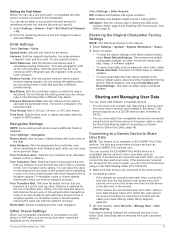
...lowering this value can improve autopilot accuracy. DSC: Enables and disables digital selective calling (DSC). This does not affect maps or software updates. • To clear saved data and reset device settings to the factory default values, disconnect the chartplotter from the first device to ... Original Chartplotter Factory Settings NOTE: This affects all devices on which a given location reading appears. You can connect the ECHOMAP Plus 40/60 device to a compatible Garmin device to NMEA 0183 devices only. The trend is connected to an AIS device or VHF radio, you can set up...
...lowering this value can improve autopilot accuracy. DSC: Enables and disables digital selective calling (DSC). This does not affect maps or software updates. • To clear saved data and reset device settings to the factory default values, disconnect the chartplotter from the first device to ... Original Chartplotter Factory Settings NOTE: This affects all devices on which a given location reading appears. You can connect the ECHOMAP Plus 40/60 device to a compatible Garmin device to NMEA 0183 devices only. The trend is connected to an AIS device or VHF radio, you can set up...
Owners Manual PDF
Page 47
...installed on the memory card. 3 Remove the memory card. 4 Insert the memory card into the card slot. A Garmin folder containing the software update is running Windows® software. Screenshots You can transfer the screenshot to your device. The chartplotter opens the card ...Select Download next to echoMAP Series with SD Card. 5 Read and agree to the terms. 6 Select Download. 7 Choose a location, and select Save. 8 Double-click the downloaded file. Updating the Device Software Before you can contact Garmin customer support to order a preloaded software update card if you do ...
...installed on the memory card. 3 Remove the memory card. 4 Insert the memory card into the card slot. A Garmin folder containing the software update is running Windows® software. Screenshots You can transfer the screenshot to your device. The chartplotter opens the card ...Select Download next to echoMAP Series with SD Card. 5 Read and agree to the terms. 6 Select Download. 7 Choose a location, and select Save. 8 Double-click the downloaded file. Updating the Device Software Before you can contact Garmin customer support to order a preloaded software update card if you do ...
Owners Manual PDF
Page 48
If not, update the device software (Updating the Device Software, page 41). • Make sure the device has a clear view .... Temperature range From -15° to 55°C (from 5° to 131°F) Input voltage From 9 to www.garmin.com /waterrating. For example, you should be a few weeks or months, the device may not match the map datum and ...• Push the transducer cable all models. 4-Inch Models Specification Dimensions on the computer. If it is at support.garmin.com. Changing the Fuse in the Power Cable 1 Open the fuse housing . 2 Twist and pull the fuse to ...
If not, update the device software (Updating the Device Software, page 41). • Make sure the device has a clear view .... Temperature range From -15° to 55°C (from 5° to 131°F) Input voltage From 9 to www.garmin.com /waterrating. For example, you should be a few weeks or months, the device may not match the map datum and ...• Push the transducer cable all models. 4-Inch Models Specification Dimensions on the computer. If it is at support.garmin.com. Changing the Fuse in the Power Cable 1 Open the fuse housing . 2 Twist and pull the fuse to ...
Owners Manual PDF
Page 50
... 129029 129283 129284 129285 129540 Description Transmit and receive PGN list group function Magnetic Variance Position: Rapid update COG and SOG: Rapid update GNSS position data Cross track error Navigation data Navigation route and waypoint info GNSS satellites in view Receive...127498 127505 129038 129039 129040 129794 129798 128000 129802 129808 130310 130311 130313 130314 130576 Description Rudder Vessel heading Engine parameters: Rapid update Engine parameters: Dynamic Transmission parameters: Dynamic Engine parameters: Static Fluid level AIS class A position report AIS class B position ...
... 129029 129283 129284 129285 129540 Description Transmit and receive PGN list group function Magnetic Variance Position: Rapid update COG and SOG: Rapid update GNSS position data Cross track error Navigation data Navigation route and waypoint info GNSS satellites in view Receive...127498 127505 129038 129039 129040 129794 129798 128000 129802 129808 130310 130311 130313 130314 130576 Description Rudder Vessel heading Engine parameters: Rapid update Engine parameters: Dynamic Transmission parameters: Dynamic Engine parameters: Static Fluid level AIS class A position report AIS class B position ...

Owners Manual PDF
Page 51
... 32, 36, 37 fuel gauges 32, 37 status alarm 32, 39 synchronizing with actual fuel 32, 37 G Garmin ClearVü 20 Garmin Marine Network 38 Garmin product support. See charts marine services 13 mark location 13 MARPA, navigation chart 10 measuring distance 23 charts 5 media...34 zones 34 memory card 40 detailed maps 40 installing 2 slot 1 MOB, device 8 music player 33, 35. Index A ActiveCaptain 3 quickdraw 11 smart notifications 4 updating charts 4 updating software 4 aerial photos 7 AIS 7, 8, 10 alarm 8 ATONs 8 distress signal device 8 SART 8 targeting 7, 8 threats 8 turning on 39 alarms 17, ...
... 32, 36, 37 fuel gauges 32, 37 status alarm 32, 39 synchronizing with actual fuel 32, 37 G Garmin ClearVü 20 Garmin Marine Network 38 Garmin product support. See charts marine services 13 mark location 13 MARPA, navigation chart 10 measuring distance 23 charts 5 media...34 zones 34 memory card 40 detailed maps 40 installing 2 slot 1 MOB, device 8 music player 33, 35. Index A ActiveCaptain 3 quickdraw 11 smart notifications 4 updating charts 4 updating software 4 aerial photos 7 AIS 7, 8, 10 alarm 8 ATONs 8 distress signal device 8 SART 8 targeting 7, 8 threats 8 turning on 39 alarms 17, ...

Owners Manual PDF
Page 52
... 36 sharing data 39, 40 shoreline distance 16 shortcuts 2, 30 SideVü 20 SiriusXM, Satellite Radio 35 SiriusXM Satellite Radio 35 smart notifications 4 software updates 36, 41 updating 4, 41 sonar 19, 20, 23 a-scope 22, 25, 26 alarms 25 appearance 25 bottom lock 24 color gain 24 color rejection 25 cone 10... depth 24 depth line 24 depth scale 24 flasher 22 frequencies 25, 26 FrontVü 22 gain 23 Garmin ClearVü 20 interference 25 measuring distances...
... 36 sharing data 39, 40 shoreline distance 16 shortcuts 2, 30 SideVü 20 SiriusXM, Satellite Radio 35 SiriusXM Satellite Radio 35 smart notifications 4 software updates 36, 41 updating 4, 41 sonar 19, 20, 23 a-scope 22, 25, 26 alarms 25 appearance 25 bottom lock 24 color gain 24 color rejection 25 cone 10... depth 24 depth line 24 depth scale 24 flasher 22 frequencies 25, 26 FrontVü 22 gain 23 Garmin ClearVü 20 interference 25 measuring distances...
