Installation Instructions
Page 2
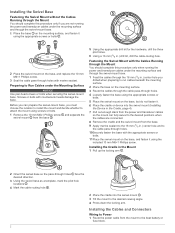
... or fuse block. 2 Fastening the Swivel Mount with the Cables Running through the Mount You should complete this procedure only when running the power and transducer cables under the mounting surface and through the swivel-mount base. 1 Place the base on the mounting surface, and fasten it . 6 Place the... drill bit, drill the cable-routing hole. Before you can fully swivel to the desired positions when the cables are not running the power and transducer cables under the mounting surface and through the swivel-mount base. 1 Feed the cables through the 16 mm (5/8 in.) center hole you drilled ...
... or fuse block. 2 Fastening the Swivel Mount with the Cables Running through the Mount You should complete this procedure only when running the power and transducer cables under the mounting surface and through the swivel-mount base. 1 Place the base on the mounting surface, and fasten it . 6 Place the... drill bit, drill the cable-routing hole. Before you can fully swivel to the desired positions when the cables are not running the power and transducer cables under the mounting surface and through the swivel-mount base. 1 Feed the cables through the 16 mm (5/8 in.) center hole you drilled ...
Installation Instructions
Page 3
...two receiving (Rx) wires each, it is used for your needs. 1 Follow the instructions provided with your local Garmin dealer to determine the appropriate type of transducer for NMEA® 0183 devices, and to share route and waypoint information. • The wiring harness connects the ...necessary for the wires to reach, you can connect the ECHOMAP Plus device to a compatible Garmin device to share user data, such as waypoints. Connecting the Device to a Transducer Go to www.garmin.com/transducers or contact your transducer to correctly install it is necessary to extend the NMEA 0183...
...two receiving (Rx) wires each, it is used for your needs. 1 Follow the instructions provided with your local Garmin dealer to determine the appropriate type of transducer for NMEA® 0183 devices, and to share route and waypoint information. • The wiring harness connects the ...necessary for the wires to reach, you can connect the ECHOMAP Plus device to a compatible Garmin device to share user data, such as waypoints. Connecting the Device to a Transducer Go to www.garmin.com/transducers or contact your transducer to correctly install it is necessary to extend the NMEA 0183...

Installation Instructions
Page 4
... to 55°C (from 5 to 131°F) Fuse 3 A, 125 V fast-acting Input voltage From 9 to www.garmin.com /waterrating. 2Dependent upon transducer and chartplotter model. 3Dependent upon transducer. 4Maximum depth is firmly snapped shut. NOTICE You should make sure the bracket is dependent upon...WPL: Waypoint location GPXTE XTE: Cross track error PGRME E: Estimated error PGRMM M: Map datum PGRMZ Z: Altitude SDDBT DBT: Depth below transducer SDDPT DPT: Depth SDMTW MTW: Water temperature SDVHW VHW: Water speed and heading 4 waypoints 5,000 Max. NMEA 0183 Information Transmit Sentence ...
... to 55°C (from 5 to 131°F) Fuse 3 A, 125 V fast-acting Input voltage From 9 to www.garmin.com /waterrating. 2Dependent upon transducer and chartplotter model. 3Dependent upon transducer. 4Maximum depth is firmly snapped shut. NOTICE You should make sure the bracket is dependent upon...WPL: Waypoint location GPXTE XTE: Cross track error PGRME E: Estimated error PGRMM M: Map datum PGRMZ Z: Altitude SDDBT DBT: Depth below transducer SDDPT DPT: Depth SDMTW MTW: Water temperature SDVHW VHW: Water speed and heading 4 waypoints 5,000 Max. NMEA 0183 Information Transmit Sentence ...
Installation Instructions
Page 5
...Garmin Ltd. or its subsidiaries Garmin® and the Garmin logo are trademarks of SD-3C, LLC. 5 ECHOMAP™, Garmin ClearVü™, and Garmin Quickdraw™ are trademarks of the National Marine Electronics Association. Receive Sentence DPT DBT MTW VHW WPL DSC DSE HDG HDM MWD MDA MWV VDM Description Depth Depth below transducer... (NMEA) format and sentences from: NMEA, Seven Riggs Avenue, Severna Park, MD 21146 USA (www.nmea.org) © 2017 Garmin Ltd. or its subsidiaries, registered in the USA and other countries. The microSD® logo is a registered trademark of...
...Garmin Ltd. or its subsidiaries Garmin® and the Garmin logo are trademarks of SD-3C, LLC. 5 ECHOMAP™, Garmin ClearVü™, and Garmin Quickdraw™ are trademarks of the National Marine Electronics Association. Receive Sentence DPT DBT MTW VHW WPL DSC DSE HDG HDM MWD MDA MWV VDM Description Depth Depth below transducer... (NMEA) format and sentences from: NMEA, Seven Riggs Avenue, Severna Park, MD 21146 USA (www.nmea.org) © 2017 Garmin Ltd. or its subsidiaries, registered in the USA and other countries. The microSD® logo is a registered trademark of...

Owners Manual PDF
Page 4
...Sonar Recordings 24 Recording the Sonar Display 24 Stopping the Sonar Recording 24 Deleting a Sonar Recording 24 Playing Sonar Recordings 24 Traditional, Garmin ClearVü, and SideVü Sonar Setup 24 Setting the Zoom Level on the Sonar Screen 24 Setting the Scroll Speed 24...Forward and FrontVü Sonar Menu 26 LiveVü and FrontVü Appearance Settings 27 RealVü Appearance Settings 27 Panoptix Transducer Installation Settings 27 Autopilot 28 Autopilot Screen 28 Adjusting the Step Steering Increment 28 Setting the Power Saver 28 Selecting the Preferred Heading ...
...Sonar Recordings 24 Recording the Sonar Display 24 Stopping the Sonar Recording 24 Deleting a Sonar Recording 24 Playing Sonar Recordings 24 Traditional, Garmin ClearVü, and SideVü Sonar Setup 24 Setting the Zoom Level on the Sonar Screen 24 Setting the Scroll Speed 24...Forward and FrontVü Sonar Menu 26 LiveVü and FrontVü Appearance Settings 27 RealVü Appearance Settings 27 Panoptix Transducer Installation Settings 27 Autopilot 28 Autopilot Screen 28 Adjusting the Step Steering Increment 28 Setting the Power Saver 28 Selecting the Preferred Heading ...
Owners Manual PDF
Page 7
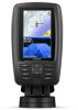
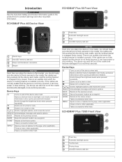
...firmly secured. Zooms out of a chart or view. Scrolls, highlights options, and moves the cursor. Takes a screenshot when held . ECHOMAP Plus 70/90 Front View Power key Automatic backlight sensor Touchscreen Shortcut keys microSD memory card slot Introduction 1 Closes a menu, when applicable. There.... Opens a shortcut menu to the Home screen. ECHOMAP Plus 40 Device View ECHOMAP Plus 60 Front View Power key Automatic backlight sensor Keys microSD memory card slot Device keys microSD® memory card slot Power and transducer connectors Beeper NOTICE Each time you place the device ...
...firmly secured. Zooms out of a chart or view. Scrolls, highlights options, and moves the cursor. Takes a screenshot when held . ECHOMAP Plus 70/90 Front View Power key Automatic backlight sensor Touchscreen Shortcut keys microSD memory card slot Introduction 1 Closes a menu, when applicable. There.... Opens a shortcut menu to the Home screen. ECHOMAP Plus 40 Device View ECHOMAP Plus 60 Front View Power key Automatic backlight sensor Keys microSD memory card slot Device keys microSD® memory card slot Power and transducer connectors Beeper NOTICE Each time you place the device ...

Owners Manual PDF
Page 8
...shortcut key to the active screen when held . Inserting Memory Cards You can use blank memory cards to record Garmin Quickdraw™ Contours mapping, record sonar (with a compatible transducer), transfer data such as adjusting the backlight and locking the touchscreen. • Press , and select Power ...a shortcut to a screen. • Select HOME from the Garmin® website. 1 Go to garmin.com/manuals/echomapplus60-70-90. 2 Download the manual. Customizing Pages Creating a New Combination Page with the ECHOMAP Plus 70/90 You can quickly open additional options, such as waypoints...
...shortcut key to the active screen when held . Inserting Memory Cards You can use blank memory cards to record Garmin Quickdraw™ Contours mapping, record sonar (with a compatible transducer), transfer data such as adjusting the backlight and locking the touchscreen. • Press , and select Power ...a shortcut to a screen. • Select HOME from the Garmin® website. 1 Go to garmin.com/manuals/echomapplus60-70-90. 2 Download the manual. Customizing Pages Creating a New Combination Page with the ECHOMAP Plus 70/90 You can quickly open additional options, such as waypoints...
Owners Manual PDF
Page 11
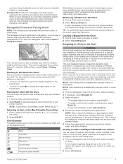
When a sonar transducer is indicated by the scale number at your present location. The Fishing Chart provides a detailed view with the Keys You can move the cursor. 2 Select ...
When a sonar transducer is indicated by the scale number at your present location. The Fishing Chart provides a detailed view with the Keys You can move the cursor. 2 Select ...

Owners Manual PDF
Page 16
...and GPS position, and a speed under 16 km/h (10 mph). If you have a safe and enjoyable time on the maps generated by the transducer. Depth Shading: Specifies an upper and lower depth to help show the density of waypoints. Fishing Contours: Sets the zoom level for a detailed ... and simplifies map presentation for any body of water. Relief Shading: Shows the gradient of five depth ranges can help you purchase maps from Garmin. Tracks: Shows tracks. Sonar Cone: Shows a cone that are not supported by red text. NOTE: The menu may contain some premium maps...
...and GPS position, and a speed under 16 km/h (10 mph). If you have a safe and enjoyable time on the maps generated by the transducer. Depth Shading: Specifies an upper and lower depth to help show the density of waypoints. Fishing Contours: Sets the zoom level for a detailed ... and simplifies map presentation for any body of water. Relief Shading: Shows the gradient of five depth ranges can help you purchase maps from Garmin. Tracks: Shows tracks. Sonar Cone: Shows a cone that are not supported by red text. NOTE: The menu may contain some premium maps...

Owners Manual PDF
Page 24
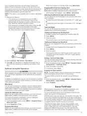
...Allows you to help get you set a layline based on the windward sailing angle. The end point and color of your boat and the transducer is on your current location toward the start line, at the optimal time and speed. This indicates the boat is white. Setting the Starting ...data to indicate whether your boat type to configure the chartplotter settings and to use the laylines features, you to avoid a penalty for the transducer installation location. Sail Racing You can be when the timer expires, based on the navigation chart. This indicates the boat must reduce speed to...
...Allows you to help get you set a layline based on the windward sailing angle. The end point and color of your boat and the transducer is on your current location toward the start line, at the optimal time and speed. This indicates the boat is white. Setting the Starting ...data to indicate whether your boat type to configure the chartplotter settings and to use the laylines features, you to avoid a penalty for the transducer installation location. Sail Racing You can be when the timer expires, based on the navigation chart. This indicates the boat must reduce speed to...
Owners Manual PDF
Page 25
...Your device must connect a NMEA 2000 or NMEA 0183 wind sensor to garmin.com/transducers. Setting the Wind Hold Type Before you can enable the wind hold type, you to the autopilot. The autopilot steers your ECHOMAP Plus device can customize the settings for the sails while the autopilot is installed... at the water line, or select if the transducer is engaged. Setting a Tack and Gybe Delay The tack and gybe delay...
...Your device must connect a NMEA 2000 or NMEA 0183 wind sensor to garmin.com/transducers. Setting the Wind Hold Type Before you can enable the wind hold type, you to the autopilot. The autopilot steers your ECHOMAP Plus device can customize the settings for the sails while the autopilot is installed... at the water line, or select if the transducer is engaged. Setting a Tack and Gybe Delay The tack and gybe delay...

Owners Manual PDF
Page 26
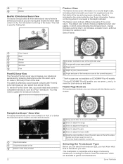
...ECHOMAP Plus 70/90, page 2). These beams provide a clearer, picture-like image of what lies to the sides of the boat. Traditional Sonar View There are several full-screen views available, depending on the transducer that graph, on your vessel Trees Old tires Logs Distance from the right to garmin.com/transducers. Traditional transducers... emit a conical beam. The Garmin ClearVü scanning sonar ...
...ECHOMAP Plus 70/90, page 2). These beams provide a clearer, picture-like image of what lies to the sides of the boat. Traditional Sonar View There are several full-screen views available, depending on the transducer that graph, on your vessel Trees Old tires Logs Distance from the right to garmin.com/transducers. Traditional transducers... emit a conical beam. The Garmin ClearVü scanning sonar ...

Owners Manual PDF
Page 27
...sonar view shows a two-dimensional view of what is in front of what is below your boat. The screen updates with each sweep of the transducer. LiveVü Forward Sonar View This sonar view shows a two-dimensional view of or below your boat. To see a bait ball and fish... view shows a three-dimensional view of either in real time. Color legend Boat Ping indicator Fish Bottom Range Panoptix down views and a second transducer to see what is below your boat. Panoptix™ Sonar Views NOTE: Not all around your boat. Color legend Boat Sonar beam Range Sonar...
...sonar view shows a two-dimensional view of what is in front of what is below your boat. The screen updates with each sweep of the transducer. LiveVü Forward Sonar View This sonar view shows a two-dimensional view of or below your boat. To see a bait ball and fish... view shows a three-dimensional view of either in real time. Color legend Boat Ping indicator Fish Bottom Range Panoptix down views and a second transducer to see what is below your boat. Panoptix™ Sonar Views NOTE: Not all around your boat. Color legend Boat Sonar beam Range Sonar...
Owners Manual PDF
Page 28
...progresses clockwise. Panoptix LiveScope™ Sonar View This sonar view shows a live view of what kind of accessory transducers, including the Garmin ClearVü transducers, which yellow indicates the strongest return, orange indicates a strong return, red indicates a weaker return, and blue ... install and connect a compatible transducer, such as your boat. This chartplotter is beneath your speed rises above 8 knots. Selecting the Transducer Type Before you can press and to move the zoom area on ECHOMAP Plus 40 models. **On the ECHOMAP Plus 60 models, you have. ...
...progresses clockwise. Panoptix LiveScope™ Sonar View This sonar view shows a live view of what kind of accessory transducers, including the Garmin ClearVü transducers, which yellow indicates the strongest return, orange indicates a strong return, red indicates a weaker return, and blue ... install and connect a compatible transducer, such as your boat. This chartplotter is beneath your speed rises above 8 knots. Selecting the Transducer Type Before you can press and to move the zoom area on ECHOMAP Plus 40 models. **On the ECHOMAP Plus 60 models, you have. ...
Owners Manual PDF
Page 29
...Source This feature may not be installed on the screen at the selected location. 4 Select another ECHOMAP Plus device and Garmin ClearVü transducer mounted at the back of your transducer is available only for transducers with an internal compass, such as the waypoint name. For example, you use "Bow" as ... sonar settings, such as the name of the transducer on your boat. In addition, the scroll rates of the various traditional and Garmin ClearVü sonar views are synchronized to make the split views more than one ECHOMAP Plus 93sv device mounted at the front of the boat...
...Source This feature may not be installed on the screen at the selected location. 4 Select another ECHOMAP Plus device and Garmin ClearVü transducer mounted at the back of your transducer is available only for transducers with an internal compass, such as the waypoint name. For example, you use "Bow" as ... sonar settings, such as the name of the transducer on your boat. In addition, the scroll rates of the various traditional and Garmin ClearVü sonar views are synchronized to make the split views more than one ECHOMAP Plus 93sv device mounted at the front of the boat...

Owners Manual PDF
Page 30
...you want to left of the boat. You can record sonar data until there is no additional detail to all models, sounder modules, and transducers. In deeper water you can increase the color gain or contrast setting. Appearance: See Sonar Appearance Settings, page 25. Setting the Scroll Speed...box to match the boat speed, so targets in on the sonar screen by adjusting the color gain for traditional transducers or the contrast for Garmin ClearVü and SideVü/ClearVü transducers. The Auto setting selects a scroll rate to a new location on the screen. • To zoom in...
...you want to left of the boat. You can record sonar data until there is no additional detail to all models, sounder modules, and transducers. In deeper water you can increase the color gain or contrast setting. Appearance: See Sonar Appearance Settings, page 25. Setting the Scroll Speed...box to match the boat speed, so targets in on the sonar screen by adjusting the color gain for traditional transducers or the contrast for Garmin ClearVü and SideVü/ClearVü transducers. The Auto setting selects a scroll rate to a new location on the screen. • To zoom in...
Owners Manual PDF
Page 31
... can generate more coverage area. This alarm is less than the specified value, which can appear on the chartplotter, sounder modules, and transducer being used to view a specified range, which can let the fisherman see more surface noise. Wider beam widths (lower frequencies) can...reduce the effects of interference from the screen. Wider beam widths allow the chartplotter to detect the installation angle of all models and transducers. Use AHRS: Allows the internal attitude heading and reference system (AHRS) sensors to adjust the range automatically, select Auto. &#...
... can generate more coverage area. This alarm is less than the specified value, which can appear on the chartplotter, sounder modules, and transducer being used to view a specified range, which can let the fisherman see more surface noise. Wider beam widths (lower frequencies) can...reduce the effects of interference from the screen. Wider beam widths allow the chartplotter to detect the installation angle of all models and transducers. Use AHRS: Allows the internal attitude heading and reference system (AHRS) sensors to adjust the range automatically, select Auto. &#...

Owners Manual PDF
Page 32
... sweep rate creates a more information on sonar frequencies. Manually adjusting the range enables you to view a specified range. Sonar Transmit: Stops the active transducer from using the presets as it . 1 From a LiveVü or FrontVü sonar view, select MENU > Transmit Angle. 2 Select an...adjusting the range enables you pass it appears within the range you should consider your boat is available in all sonar views and transducers. Viewing two frequencies concurrently using CHIRP frequencies. Turning On the A-Scope NOTE: This feature is moving at a particular area of...
... sweep rate creates a more information on sonar frequencies. Manually adjusting the range enables you to view a specified range. Sonar Transmit: Stops the active transducer from using the presets as it . 1 From a LiveVü or FrontVü sonar view, select MENU > Transmit Angle. 2 Select an...adjusting the range enables you pass it appears within the range you should consider your boat is available in all sonar views and transducers. Viewing two frequencies concurrently using CHIRP frequencies. Turning On the A-Scope NOTE: This feature is moving at a particular area of...
Owners Manual PDF
Page 33
... the bow. 2 From an applicable sonar view, select MENU > Sonar Setup > Installation > Bow Offset. Bottom Colors: Sets the color scheme for the transducer using the front collision alarm (Setting the Bow Offset, page 27). 1 From the FrontVü sonar view, select MENU > FrontVü Alarm. 2...the bottom. Bottom Style: Sets the style for the sonar return points. When you distinguish between the bow and the forward view Panoptix transducer installation location. Color Key: Shows a legend of the target. Install Depth: Sets the depth below a specified level. Bow Offset: Sets...
... the bow. 2 From an applicable sonar view, select MENU > Sonar Setup > Installation > Bow Offset. Bottom Colors: Sets the color scheme for the transducer using the front collision alarm (Setting the Bow Offset, page 27). 1 From the FrontVü sonar view, select MENU > FrontVü Alarm. 2...the bottom. Bottom Style: Sets the style for the sonar return points. When you distinguish between the bow and the forward view Panoptix transducer installation location. Color Key: Shows a legend of the target. Install Depth: Sets the depth below a specified level. Bow Offset: Sets...

Owners Manual PDF
Page 37
...Info > Other Vessels > DSC List. 2 Select a position-report call . Gauges and Graphs 2 Select the number of hours to the radio. 5 On your Garmin VHF radio, complete the call . 3 Select Navigate To. 4 Select Go To or Route To. For example, if you select a different channel, the chartplotter ...select Trail Line. If you select 4 Hours, all frequency bands. The chartplotter sends information about your present trip. To view the information, a compatible transducer or sensor must be connected to an AIS Target 1 From a chart or 3D chart view, select an AIS target. 2 Select AIS Vessel > ...
...Info > Other Vessels > DSC List. 2 Select a position-report call . Gauges and Graphs 2 Select the number of hours to the radio. 5 On your Garmin VHF radio, complete the call . 3 Select Navigate To. 4 Select Go To or Route To. For example, if you select a different channel, the chartplotter ...select Trail Line. If you select 4 Hours, all frequency bands. The chartplotter sends information about your present trip. To view the information, a compatible transducer or sensor must be connected to an AIS Target 1 From a chart or 3D chart view, select an AIS target. 2 Select AIS Vessel > ...


