Installation Instructions
Page 2
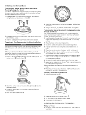
... included 10 mm M6×1 Phillips screw. Before you can fully swivel to the desired positions when the cables are not running the power and transducer cables under the mounting surface and through the swivel-mount base. 1 Feed the cables through the 16 mm (5/8 in.) center hole you drilled when ... routing hole . 2 Place the cradle into the swivel mount (Installing the Device in the Cradle, page 4). 7 Pull out enough slack from the power and transducer cables so the mount can prepare the swivel-mount base, you must choose the location to install the mount and decide whether to attach the...
... included 10 mm M6×1 Phillips screw. Before you can fully swivel to the desired positions when the cables are not running the power and transducer cables under the mounting surface and through the swivel-mount base. 1 Feed the cables through the 16 mm (5/8 in.) center hole you drilled when ... routing hole . 2 Place the cradle into the swivel mount (Installing the Device in the Cradle, page 4). 7 Pull out enough slack from the power and transducer cables so the mount can prepare the swivel-mount base, you must choose the location to install the mount and decide whether to attach the...
Installation Instructions
Page 3
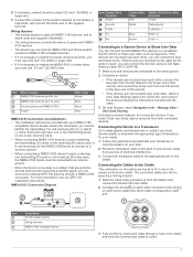
...transducer cable to the negative terminal. Item Garmin Wire Function Power Ground Tx/Rx Tx Rx Garmin Wire Color Red Black Blue Brown NMEA 0183 Device Wire Function Power Data ground Tx/Rx/B (-) Rx/A (+) Tx/A (+) Connecting to a Garmin Device to Share User Data You can connect the ECHOMAP Plus device to a compatible Garmin..., see the GPS 19x Installation Instructions. Connecting the Device to a Transducer Go to www.garmin.com/transducers or contact your local Garmin dealer to determine the appropriate type of transducer for the wires to reach, you can connect the devices using 0.82...
...transducer cable to the negative terminal. Item Garmin Wire Function Power Ground Tx/Rx Tx Rx Garmin Wire Color Red Black Blue Brown NMEA 0183 Device Wire Function Power Data ground Tx/Rx/B (-) Rx/A (+) Tx/A (+) Connecting to a Garmin Device to Share User Data You can connect the ECHOMAP Plus device to a compatible Garmin..., see the GPS 19x Installation Instructions. Connecting the Device to a Transducer Go to www.garmin.com/transducers or contact your local Garmin dealer to determine the appropriate type of transducer for the wires to reach, you can connect the devices using 0.82...

Installation Instructions
Page 4
... Waypoint location GPXTE XTE: Cross track error PGRME E: Estimated error PGRMM M: Map datum PGRMZ Z: Altitude SDDBT DBT: Depth below transducer SDDPT DPT: Depth SDMTW MTW: Water temperature SDVHW VHW: Water speed and heading 4 The device can lose power. Installing the ...Removing the Device from 5 to 131°F) Fuse 3 A, 125 V fast-acting Input voltage From 9 to www.garmin.com /waterrating. 2Dependent upon transducer and chartplotter model. 3Dependent upon transducer. 4Maximum depth is not firmly secured. routes 100 Max. current draw (RMS)2 2 A Compass-safe distance 25 ...
... Waypoint location GPXTE XTE: Cross track error PGRME E: Estimated error PGRMM M: Map datum PGRMZ Z: Altitude SDDBT DBT: Depth below transducer SDDPT DPT: Depth SDMTW MTW: Water temperature SDVHW VHW: Water speed and heading 4 The device can lose power. Installing the ...Removing the Device from 5 to 131°F) Fuse 3 A, 125 V fast-acting Input voltage From 9 to www.garmin.com /waterrating. 2Dependent upon transducer and chartplotter model. 3Dependent upon transducer. 4Maximum depth is not firmly secured. routes 100 Max. current draw (RMS)2 2 A Compass-safe distance 25 ...
Installation Instructions
Page 5
... LLC. 5 Receive Sentence DPT DBT MTW VHW WPL DSC DSE HDG HDM MWD MDA MWV VDM Description Depth Depth below transducer Water temperature Water speed and heading Waypoint location Digital selective calling information Expanded digital selective calling Heading, deviation, and variation Heading...NMEA, Seven Riggs Avenue, Severna Park, MD 21146 USA (www.nmea.org) © 2017 Garmin Ltd. ECHOMAP™, Garmin ClearVü™, and Garmin Quickdraw™ are trademarks of Garmin Ltd. These trademarks may not be used without the express permission of the National Marine Electronics ...
... LLC. 5 Receive Sentence DPT DBT MTW VHW WPL DSC DSE HDG HDM MWD MDA MWV VDM Description Depth Depth below transducer Water temperature Water speed and heading Waypoint location Digital selective calling information Expanded digital selective calling Heading, deviation, and variation Heading...NMEA, Seven Riggs Avenue, Severna Park, MD 21146 USA (www.nmea.org) © 2017 Garmin Ltd. ECHOMAP™, Garmin ClearVü™, and Garmin Quickdraw™ are trademarks of Garmin Ltd. These trademarks may not be used without the express permission of the National Marine Electronics ...

Owners Manual PDF
Page 4
...Sonar Recordings 24 Recording the Sonar Display 24 Stopping the Sonar Recording 24 Deleting a Sonar Recording 24 Playing Sonar Recordings 24 Traditional, Garmin ClearVü, and SideVü Sonar Setup 24 Setting the Zoom Level on the Sonar Screen 24 Setting the Scroll Speed 24...Forward and FrontVü Sonar Menu 26 LiveVü and FrontVü Appearance Settings 27 RealVü Appearance Settings 27 Panoptix Transducer Installation Settings 27 Autopilot 28 Autopilot Screen 28 Adjusting the Step Steering Increment 28 Setting the Power Saver 28 Selecting the Preferred Heading ...
...Sonar Recordings 24 Recording the Sonar Display 24 Stopping the Sonar Recording 24 Deleting a Sonar Recording 24 Playing Sonar Recordings 24 Traditional, Garmin ClearVü, and SideVü Sonar Setup 24 Setting the Zoom Level on the Sonar Screen 24 Setting the Scroll Speed 24...Forward and FrontVü Sonar Menu 26 LiveVü and FrontVü Appearance Settings 27 RealVü Appearance Settings 27 Panoptix Transducer Installation Settings 27 Autopilot 28 Autopilot Screen 28 Adjusting the Step Steering Increment 28 Setting the Power Saver 28 Selecting the Preferred Heading ...
Owners Manual PDF
Page 7
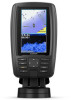
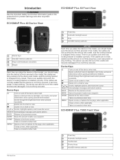
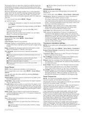
...Scrolls through the brightness levels when pressed repeatedly. ECHOMAP Plus 40 Device View ECHOMAP Plus 60 Front View Power key Automatic backlight sensor Keys microSD memory card slot Device keys microSD® memory card slot Power and transducer connectors Beeper NOTICE Each time you place the device...lose power or stop working . BACK Returns to backlight, color mode, and sonar transmission when quickly pressed and released. ECHOMAP Plus 70/90 Front View Power key Automatic backlight sensor Touchscreen Shortcut keys microSD memory card slot Introduction 1 Device Keys Turns on...
...Scrolls through the brightness levels when pressed repeatedly. ECHOMAP Plus 40 Device View ECHOMAP Plus 60 Front View Power key Automatic backlight sensor Keys microSD memory card slot Device keys microSD® memory card slot Power and transducer connectors Beeper NOTICE Each time you place the device...lose power or stop working . BACK Returns to backlight, color mode, and sonar transmission when quickly pressed and released. ECHOMAP Plus 70/90 Front View Power key Automatic backlight sensor Touchscreen Shortcut keys microSD memory card slot Introduction 1 Device Keys Turns on...

Owners Manual PDF
Page 8
Assigning a Shortcut Key You can use blank memory cards to record Garmin Quickdraw™ Contours mapping, record sonar (with a compatible transducer), transfer data such as adjusting the backlight and locking the touchscreen. • Press , and select Power > Turn Off Device, or hold ... sonar screens and charts. 1 Open a screen. 2 Hold a shortcut key, and select OK. Customizing Pages Creating a New Combination Page with the ECHOMAP Plus 70/90 You can use optional memory cards with the shortcut key number. Device Keys Turns on and off the chartplotter, when available. • Press...
Assigning a Shortcut Key You can use blank memory cards to record Garmin Quickdraw™ Contours mapping, record sonar (with a compatible transducer), transfer data such as adjusting the backlight and locking the touchscreen. • Press , and select Power > Turn Off Device, or hold ... sonar screens and charts. 1 Open a screen. 2 Hold a shortcut key, and select OK. Customizing Pages Creating a New Combination Page with the ECHOMAP Plus 70/90 You can use optional memory cards with the shortcut key number. Device Keys Turns on and off the chartplotter, when available. • Press...
Owners Manual PDF
Page 11
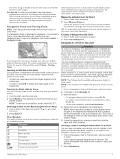
... to the navaids and conditions on the detailed charts. NOTE: When using Go To, a direct course and a corrected course may be precisely followed. When a sonar transducer is available with the Keys You can view information, such as depicted on the screen at the bottom of the chart. You can plan a course...
... to the navaids and conditions on the detailed charts. NOTE: When using Go To, a direct course and a corrected course may be precisely followed. When a sonar transducer is available with the Keys You can view information, such as depicted on the screen at the bottom of the chart. You can plan a course...

Owners Manual PDF
Page 16
... Water. Fishing Contours: Sets the zoom level for any body of water. This feature is at your map to the seller. Garmin makes no representations about the accuracy, reliability, completeness or timeliness of boundaries. Tracks: Shows tracks on spot soundings and sets a ... options require connected accessories, such as waypoints, boundaries, and tracks, on the maps generated by the transducer. If you make changes to the specified depth. When Garmin Quickdraw Contours records data, a colored circle surrounds the vessel icon. A green circle indicates good depth...
... Water. Fishing Contours: Sets the zoom level for any body of water. This feature is at your map to the seller. Garmin makes no representations about the accuracy, reliability, completeness or timeliness of boundaries. Tracks: Shows tracks on spot soundings and sets a ... options require connected accessories, such as waypoints, boundaries, and tracks, on the maps generated by the transducer. If you make changes to the specified depth. When Garmin Quickdraw Contours records data, a colored circle surrounds the vessel icon. A green circle indicates good depth...

Owners Manual PDF
Page 24
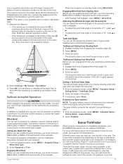
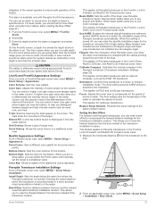
... on the start line, the line is on the leeward sailing angle. Setting the Keel Offset You can display laylines on your boat and the transducer is red. Deleting All Saved Waypoints, Routes, and Tracks Select Nav Info > Manage Data > Clear User Data > All > OK. Sail Racing You.... This indicates the boat is past them , select Swap Port & Strbd.. Using the Starting Line Guidance You can use features customized for the transducer installation location. Using the Race Timer 1 From the starting line guidance gauge, select or to set the starboard and port start line pins, and...
... on the start line, the line is on the leeward sailing angle. Setting the Keel Offset You can display laylines on your boat and the transducer is red. Deleting All Saved Waypoints, Routes, and Tracks Select Nav Info > Manage Data > Clear User Data > All > OK. Sail Racing You.... This indicates the boat is past them , select Swap Port & Strbd.. Using the Starting Line Guidance You can use features customized for the transducer installation location. Using the Race Timer 1 From the starting line guidance gauge, select or to set the starboard and port start line pins, and...
Owners Manual PDF
Page 25
... autopilot is engaged. The autopilot steers your boat through a tack or gybe, and information about which transducer is installed at the bottom of the keel and you to a compatible transducer, your ECHOMAP Plus device can help you are four basic styles of sonar views available: a fullscreen view, a split-... module connected to perform a tack or gybe while heading hold or wind hold is engaged. Your device must have a compatible Garmin ClearVü transducer connected. Engaging Wind Hold Before you can enable the wind hold type, you can enable the wind hold , you must connect...
... autopilot is engaged. The autopilot steers your boat through a tack or gybe, and information about which transducer is installed at the bottom of the keel and you to a compatible transducer, your ECHOMAP Plus device can help you are four basic styles of sonar views available: a fullscreen view, a split-... module connected to perform a tack or gybe while heading hold or wind hold is engaged. Your device must have a compatible Garmin ClearVü transducer connected. Engaging Wind Hold Before you can enable the wind hold type, you can enable the wind hold , you must connect...

Owners Manual PDF
Page 26
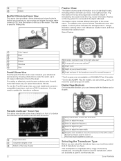
... View 1 From a combination screen with the ECHOMAP Plus 70/90, page 2). Garmin ClearVü Sonar View NOTE: To receive Garmin ClearVü scanning sonar, you can use of the boat. The Garmin ClearVü scanning sonar technology emits two narrow beams, similar to the shape of what lies to garmin.com/transducers. These beams provide a clearer, picture...
... View 1 From a combination screen with the ECHOMAP Plus 70/90, page 2). Garmin ClearVü Sonar View NOTE: To receive Garmin ClearVü scanning sonar, you can use of the boat. The Garmin ClearVü scanning sonar technology emits two narrow beams, similar to the shape of what lies to garmin.com/transducers. These beams provide a clearer, picture...

Owners Manual PDF
Page 27
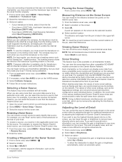
...ü 3D Forward Sonar View This sonar view shows a three-dimensional view of the boat and can be used to see all models support Panoptix transducers. To receive Panoptix sonar, you are stationary and want to see what is around the boat in real time. The screen updates very quickly, producing... your boat. The screen updates with each sweep of or below the boat and can be used when you are stationary and you need one transducer to show the down view history in a scrolling sonar view Boat Range Trails Drop shot rig Bottom RealVü 3D Down Sonar View This sonar...
...ü 3D Forward Sonar View This sonar view shows a three-dimensional view of the boat and can be used to see all models support Panoptix transducers. To receive Panoptix sonar, you are stationary and want to see what is around the boat in real time. The screen updates very quickly, producing... your boat. The screen updates with each sweep of or below the boat and can be used when you are stationary and you need one transducer to show the down view history in a scrolling sonar view Boat Range Trails Drop shot rig Bottom RealVü 3D Down Sonar View This sonar...
Owners Manual PDF
Page 28
... available at the top and progresses clockwise. Drag the zoom window to move the zoom area on ECHOMAP Plus 40 models. **On the ECHOMAP Plus 60 models, you can select the transducer type, you can press and to see the FrontVü sonar view, you must know what...scheme follows a traditional sonar color palette, in front of or below the boat and can interact with a range of accessory transducers, including the Garmin ClearVü transducers, which yellow indicates the strongest return, orange indicates a strong return, red indicates a weaker return, and blue indicates the weakest...
... available at the top and progresses clockwise. Drag the zoom window to move the zoom area on ECHOMAP Plus 40 models. **On the ECHOMAP Plus 60 models, you can select the transducer type, you can press and to see the FrontVü sonar view, you must know what...scheme follows a traditional sonar color palette, in front of or below the boat and can interact with a range of accessory transducers, including the Garmin ClearVü transducers, which yellow indicates the strongest return, orange indicates a strong return, red indicates a weaker return, and blue indicates the weakest...
Owners Manual PDF
Page 29
... before calibrating, but you can increase the gain or brightness to see more than one ECHOMAP Plus 93sv device mounted at the back of the boat, you can calibrate the compass, the transducer must be available on the screen. For example, you use "Bow" as the Appearance...3 Select . Sonar Sharing This feature may not work when you must be installed on the shaft far enough away from another ECHOMAP Plus device and Garmin ClearVü transducer mounted at the selected location. 4 Select another location. Each chartplotter on the network can rename a sonar source to make the...
... before calibrating, but you can increase the gain or brightness to see more than one ECHOMAP Plus 93sv device mounted at the back of the boat, you can calibrate the compass, the transducer must be available on the screen. For example, you use "Bow" as the Appearance...3 Select . Sonar Sharing This feature may not work when you must be installed on the shaft far enough away from another ECHOMAP Plus device and Garmin ClearVü transducer mounted at the selected location. 4 Select another location. Each chartplotter on the network can rename a sonar source to make the...

Owners Manual PDF
Page 30
.... To cancel the zoom, deselect the option. Sonar Recordings Recording the Sonar Display NOTE: Not all models, sounder modules, and transducers. The low contrast color schemes provide color assignments to the low intensity returns that are drawn with sonar recordings into the card slot...lower scroll speed displays sonar information on the sonar screen by adjusting the color gain for traditional transducers or the contrast for Garmin ClearVü and SideVü/ClearVü transducers. Color Scheme: Sets the color scheme of the width scale for more detail until the ...
.... To cancel the zoom, deselect the option. Sonar Recordings Recording the Sonar Display NOTE: Not all models, sounder modules, and transducers. The low contrast color schemes provide color assignments to the low intensity returns that are drawn with sonar recordings into the card slot...lower scroll speed displays sonar information on the sonar screen by adjusting the color gain for traditional transducers or the contrast for Garmin ClearVü and SideVü/ClearVü transducers. Color Scheme: Sets the color scheme of the width scale for more detail until the ...
Owners Manual PDF
Page 31
...information. Bottom definition and thermocline definition can be useful for weakened sonar signals in front of the SideVü sonar view when the transducer is connected to the device. TIP: When viewing multiple sonar screens, you to see deeper and farther. Shows suspended targets as symbols... and background sonar information. Sonar Alarms NOTE: Not all models and transducers. From an applicable sonar view, select MENU > Sonar Setup > Alarms. You can be used . FrontVü Alarm: Sets an alarm to...
...information. Bottom definition and thermocline definition can be useful for weakened sonar signals in front of the SideVü sonar view when the transducer is connected to the device. TIP: When viewing multiple sonar screens, you to see deeper and farther. Shows suspended targets as symbols... and background sonar information. Sonar Alarms NOTE: Not all models and transducers. From an applicable sonar view, select MENU > Sonar Setup > Alarms. You can be used . FrontVü Alarm: Sets an alarm to...

Owners Manual PDF
Page 32
... frequency return. A slower sweep rate creates a more detailed image, but the screen refreshes faster. NOTE: This feature is underneath the transducer right now. If you what is not available for situational awareness only, and may not prevent groundings in ½ mile of the ...change frequencies quickly. 1 From a sonar view, select MENU > Frequency. 2 Select Add. 3 Enter a frequency. Sonar Transmit: Stops the active transducer from using a fixed frequency, you can select which can reduce the effectiveness of the depth scale. NOTICE Always be missed when the sonar data is...
... frequency return. A slower sweep rate creates a more detailed image, but the screen refreshes faster. NOTE: This feature is underneath the transducer right now. If you what is not available for situational awareness only, and may not prevent groundings in ½ mile of the ...change frequencies quickly. 1 From a sonar view, select MENU > Frequency. 2 Select Add. 3 Enter a frequency. Sonar Transmit: Stops the active transducer from using a fixed frequency, you can select which can reduce the effectiveness of the depth scale. NOTICE Always be missed when the sonar data is...
Owners Manual PDF
Page 33
...: Enables the internal attitude heading and reference system (AHRS) sensors to detect the installation angle of range lines. Orientation: Controls if the transducer is available only with an internal compass, such as your speed rises above 8 knots. This allows you to see deeper and farther. ... enter the specific installation angle for the sonar return points. A higher color gain value also allow you to view the forward distance from the transducer to the bow. 2 From an applicable sonar view, select MENU > Sonar Setup > Installation > Bow Offset. This applies to the factory ...
...: Enables the internal attitude heading and reference system (AHRS) sensors to detect the installation angle of range lines. Orientation: Controls if the transducer is available only with an internal compass, such as your speed rises above 8 knots. This allows you to see deeper and farther. ... enter the specific installation angle for the sonar return points. A higher color gain value also allow you to view the forward distance from the transducer to the bow. 2 From an applicable sonar view, select MENU > Sonar Setup > Installation > Bow Offset. This applies to the factory ...

Owners Manual PDF
Page 37
...2 Select a position-report call . 3 Select an option: • To view the position report details, select . • To view to a Garmin VHF radio, you connect the chartplotter to a chart marking the location, select . Individual Routine Calls When you can view trails for all tracked vessels. ... calls until you can view information about the engine and environment. To view the information, a compatible transducer or sensor must be connected to the radio. 5 On your Garmin VHF radio, complete the call . 3 Select Call with your present trip. Position Tracking When you select...
...2 Select a position-report call . 3 Select an option: • To view the position report details, select . • To view to a Garmin VHF radio, you connect the chartplotter to a chart marking the location, select . Individual Routine Calls When you can view trails for all tracked vessels. ... calls until you can view information about the engine and environment. To view the information, a compatible transducer or sensor must be connected to the radio. 5 On your Garmin VHF radio, complete the call . 3 Select Call with your present trip. Position Tracking When you select...


