Important Product and Safety Information (Multilingual)
Page 2
...Minimize the amount of all available navigation sources, including information from street signs, visual sightings, and maps. It is blocked. Warning: This product, its packaging, and its components glove box. cancer, birth defects, or reproductive harm. See www.garmin.com/prop65 for various purposes,...'s Proposition 65. contain chemicals known to the State of the road or interfere with the correct replacement batteries. Battery Warnings Your GPS unit uses user-replaceable batteries. To prevent damage, remove the unit from children. • Do not disassemble, puncture, or damage...
...Minimize the amount of all available navigation sources, including information from street signs, visual sightings, and maps. It is blocked. Warning: This product, its packaging, and its components glove box. cancer, birth defects, or reproductive harm. See www.garmin.com/prop65 for various purposes,...'s Proposition 65. contain chemicals known to the State of the road or interfere with the correct replacement batteries. Battery Warnings Your GPS unit uses user-replaceable batteries. To prevent damage, remove the unit from children. • Do not disassemble, puncture, or damage...
Important Product and Safety Information (Multilingual)
Page 3
... using the suction cup mount on your Garmin device in product literature and copyright messages displayed to the consumer. The California Electronic Waste Recycling Act of 2003 requires the recycling of certain electronics. Some state laws prohibit drivers from the GPS unit. • Consult the dealer or...cause harmful interference to radio communications if not installed and used to comply with all data sources contain some countries, complete and accurate map information is either not available or is available to us at a reasonable cost. Other state laws allow the suction mount to be...
... using the suction cup mount on your Garmin device in product literature and copyright messages displayed to the consumer. The California Electronic Waste Recycling Act of 2003 requires the recycling of certain electronics. Some state laws prohibit drivers from the GPS unit. • Consult the dealer or...cause harmful interference to radio communications if not installed and used to comply with all data sources contain some countries, complete and accurate map information is either not available or is available to us at a reasonable cost. Other state laws allow the suction mount to be...
Owner's Manual
Page 4
... 1 Contact Garmin 1 Optional Accessories 1 Caring for the Dakota 1 Battery Information 2 Turning On and Off the Dakota 2 Adjusting the Backlight Level..... 3 Locking the Screen 3 Acquiring GPS Satellite Signals 3 Basic Navigation 4 Accessing Applications from the Main menu 4 Creating Waypoints 4 Navigating to a Destination........ 5 Stop Navigating 7 Using the Map 7 Using the Compass 9 Bearing and Course Pointers 10 Managing Waypoints,... 17 Calculating the Size of an Area 17 Other Tools 17 Monitoring Satellite Reception 18 Trip Computer 19 ii Dakota Series Owner's Manual
... 1 Contact Garmin 1 Optional Accessories 1 Caring for the Dakota 1 Battery Information 2 Turning On and Off the Dakota 2 Adjusting the Backlight Level..... 3 Locking the Screen 3 Acquiring GPS Satellite Signals 3 Basic Navigation 4 Accessing Applications from the Main menu 4 Creating Waypoints 4 Navigating to a Destination........ 5 Stop Navigating 7 Using the Map 7 Using the Compass 9 Bearing and Course Pointers 10 Managing Waypoints,... 17 Calculating the Size of an Area 17 Other Tools 17 Monitoring Satellite Reception 18 Trip Computer 19 ii Dakota Series Owner's Manual

Owner's Manual
Page 5
GPS Games 20 Geocaches 20 Customizing the Dakota... 21 Changing the Profile 21 Setting Up Profiles 21 Using System Setup 22 Customizing the Display.......... 22 Map Setup 23 Track Setup 24 Customizing the Main Menu 24 Route Setup 24 Changing Marine Settings........ 25...Your Dakota to a Computer........... 33 Installing a microSD™ Card 33 Transferring Tracks, Routes, or Waypoints 34 Loading and Deleting Files 35 Optimizing Battery Life 36 Restoring Factory Default Settings 36 Attaching a Carabiner, Lanyard, Mount, or Other Optional Accessory 37 Calibrating the Touchscreen 37...
GPS Games 20 Geocaches 20 Customizing the Dakota... 21 Changing the Profile 21 Setting Up Profiles 21 Using System Setup 22 Customizing the Display.......... 22 Map Setup 23 Track Setup 24 Customizing the Main Menu 24 Route Setup 24 Changing Marine Settings........ 25...Your Dakota to a Computer........... 33 Installing a microSD™ Card 33 Transferring Tracks, Routes, or Waypoints 34 Loading and Deleting Files 35 Optimizing Battery Life 36 Restoring Factory Default Settings 36 Attaching a Carabiner, Lanyard, Mount, or Other Optional Accessory 37 Calibrating the Touchscreen 37...

Owner's Manual
Page 28
... Backlight Timeout-select the amount of your current profile. GPS-select Normal, WAAS (Wide Area Augmentation System), or Demo Mode (GPS off). Language-select the text language on after you ...backlight to www.garmin.com/aboutGPS /waas.html. Battery Type-select the type of user-entered data or map data, such as street names. Press and quickly release . 22 Dakota Series Owner's... For information about WAAS, go to remain on the Dakota. Changing the text language does not change the language of battery you are unavailable with the Dakota 10. On the Main menu, touch Setup > Display >...
... Backlight Timeout-select the amount of your current profile. GPS-select Normal, WAAS (Wide Area Augmentation System), or Demo Mode (GPS off). Language-select the text language on after you ...backlight to www.garmin.com/aboutGPS /waas.html. Battery Type-select the type of user-entered data or map data, such as street names. Press and quickly release . 22 Dakota Series Owner's... For information about WAAS, go to remain on the Dakota. Changing the text language does not change the language of battery you are unavailable with the Dakota 10. On the Main menu, touch Setup > Display >...

Owner's Manual
Page 38
...Southern latitudes)* Resolution: 1 degree Altimeter: Accuracy: ± 10 ft. (± 3 m)* Resolution: 1 ft. (.3 m) Range: from -2,000 ft. 32 to 30,000 ft. (from -610 to 9144 m) *Subject to navigate using Demo mode because the GPS receiver is turned off for use indoors or for practice. Using... Demo Mode Demo mode turns the GPS receiver off . Caution: Do not try to proper user calibration. Dakota Series Owner's Manual Appendix Map Storage: Internal or microSD&#...
...Southern latitudes)* Resolution: 1 degree Altimeter: Accuracy: ± 10 ft. (± 3 m)* Resolution: 1 ft. (.3 m) Range: from -2,000 ft. 32 to 30,000 ft. (from -610 to 9144 m) *Subject to navigate using Demo mode because the GPS receiver is turned off for use indoors or for practice. Using... Demo Mode Demo mode turns the GPS receiver off . Caution: Do not try to proper user calibration. Dakota Series Owner's Manual Appendix Map Storage: Internal or microSD&#...
Owner's Manual
Page 39
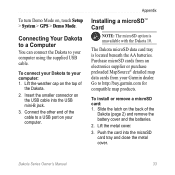
... the USB mini-B jack. 3. Insert the smaller connector on , touch Setup > System > GPS > Demo Mode. Lift the metal cover. 3. The Dakota microSD data card tray is unavailable with the Dakota 10. Slide the latch on the top of the cable to your computer. Connect the other end ...tray and close the metal cover. Connecting Your Dakota to a Computer You can connect the Dakota to http://buy.garmin.com for compatible map products. Purchase microSD cards from an electronics supplier or purchase preloaded MapSource® detailed map data cards from your computer using the supplied USB...
... the USB mini-B jack. 3. Insert the smaller connector on , touch Setup > System > GPS > Demo Mode. Lift the metal cover. 3. The Dakota microSD data card tray is unavailable with the Dakota 10. Slide the latch on the top of the cable to your computer. Connect the other end ...tray and close the metal cover. Connecting Your Dakota to a Computer You can connect the Dakota to http://buy.garmin.com for compatible map products. Purchase microSD cards from an electronics supplier or purchase preloaded MapSource® detailed map data cards from your computer using the supplied USB...

Owner's Manual
Page 46
... GPS setting 22 grid north 27 guidance method 24 H heart rate monitor 29 hunt and fish 18 L language 22 light sectors 25 lock on road 25 lock screen 3 40 M magnetic north 27 man overboard 18 map information 7 marine 25 mark waypoint 4 microSD card installing 33 loading files 35 mils 27 N navigation ... map 23 P pairing 29 plot type 28 POI 5 points of interest 5 position format 27 pressure ambient 28 barometric 28 trending 28 unit of measurement 26 profiles 21 R recent finds 5 record method, tracks 24 reverse route points 14 routes calculate 25 edit 13 reverse 14 setup 24 view 14 Dakota Series...
... GPS setting 22 grid north 27 guidance method 24 H heart rate monitor 29 hunt and fish 18 L language 22 light sectors 25 lock on road 25 lock screen 3 40 M magnetic north 27 man overboard 18 map information 7 marine 25 mark waypoint 4 microSD card installing 33 loading files 35 mils 27 N navigation ... map 23 P pairing 29 plot type 28 POI 5 points of interest 5 position format 27 pressure ambient 28 barometric 28 trending 28 unit of measurement 26 profiles 21 R recent finds 5 record method, tracks 24 reverse route points 14 routes calculate 25 edit 13 reverse 14 setup 24 view 14 Dakota Series...
Quick Start Manual
Page 3
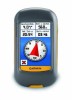
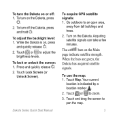
... Dakota Series Quick Start Manual To acquire GPS satellite signals: 1. Turn on the Dakota, press . 2. When the bars are green, the Dakota has acquired satellite signals. To turn on the Dakota. Your current location is on the Main page indicate satellite strength. Touch or to zoom. 3. While the Dakota ... bars on , press and quickly release . 2. Touch Map. Touch or to adjust the brightness levels. To turn the Dakota on or off the Dakota, press and hold . Touch Lock Screen (or Unlock Screen). To use the map: 1. Touch and drag the screen to an open area...
... Dakota Series Quick Start Manual To acquire GPS satellite signals: 1. Turn on the Dakota, press . 2. When the bars are green, the Dakota has acquired satellite signals. To turn on the Dakota. Your current location is on the Main page indicate satellite strength. Touch or to zoom. 3. While the Dakota ... bars on , press and quickly release . 2. Touch Map. Touch or to adjust the brightness levels. To turn the Dakota on or off the Dakota, press and hold . Touch Lock Screen (or Unlock Screen). To use the map: 1. Touch and drag the screen to an open area...


