
Important Safety and Product Information
Page 2
... on specific radio frequencies, which source code is turned on the device with Innovation, Science and Economic Development Canada license-exempt RSS standard(s). Hearing Aids-Some digital wireless radios may violate FCC regulations. Check with the manufacturer or its maximum output power mode and when used properly. Windshield Mounting Legal Restrictions Before using the messaging, tracking, and SOS functions of fire or explosion. GPS Notice The navigation device...
... on specific radio frequencies, which source code is turned on the device with Innovation, Science and Economic Development Canada license-exempt RSS standard(s). Hearing Aids-Some digital wireless radios may violate FCC regulations. Check with the manufacturer or its maximum output power mode and when used properly. Windshield Mounting Legal Restrictions Before using the messaging, tracking, and SOS functions of fire or explosion. GPS Notice The navigation device...
Important Safety and Product Information
Page 3
..., any degradation in the performance of any Garmin navigation product resulting from its use of these resources, contact a Garmin Authorized service facility in the original country of purchase or follow the instructions on frequencies that are close to the frequencies used parts that satisfy Garmin's quality standards, (ii) replace the device with a new device or a refurbished device that meets Garmin's quality standards, or (iii) exchange the...
..., any degradation in the performance of any Garmin navigation product resulting from its use of these resources, contact a Garmin Authorized service facility in the original country of purchase or follow the instructions on frequencies that are close to the frequencies used parts that satisfy Garmin's quality standards, (ii) replace the device with a new device or a refurbished device that meets Garmin's quality standards, or (iii) exchange the...
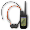
Owners Manual
Page 3
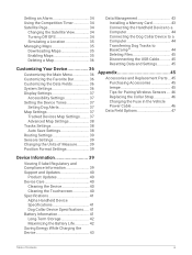
...Handheld Device 1 Dog Collar Device 3 Installing the Battery Pack 3 Charging the Handheld Device 4 Charging the Dog Collar Device 5 Turning On the Device 5 Turning Off the Device 5 Selecting a Language 5 Using the Touchscreen 5 Using the Status Page 6 Acquiring Satellite Signals 6 Iridium® Satellite Network 6 Activating the Device 6 Dog Collar Device Setup 7 Methods to Add a Dog Collar Device to a Handheld Device 7 Adding a Dog to the Alpha Navigator Using Wireless Pairing 7 Sharing a Dog Wirelessly 8 Adding a Dog Using the Track and Control Codes 8 VHF Radio Information...
...Handheld Device 1 Dog Collar Device 3 Installing the Battery Pack 3 Charging the Handheld Device 4 Charging the Dog Collar Device 5 Turning On the Device 5 Turning Off the Device 5 Selecting a Language 5 Using the Touchscreen 5 Using the Status Page 6 Acquiring Satellite Signals 6 Iridium® Satellite Network 6 Activating the Device 6 Dog Collar Device Setup 7 Methods to Add a Dog Collar Device to a Handheld Device 7 Adding a Dog to the Alpha Navigator Using Wireless Pairing 7 Sharing a Dog Wirelessly 8 Adding a Dog Using the Track and Control Codes 8 VHF Radio Information...
Owners Manual
Page 4
... Turning On Rescue Mode 28 Pausing Dog Tracking 28 Waypoints, Routes, and Tracks....... 28 Waypoints 28 Marking Your Current Location........ 28 Marking a Waypoint Using the Map 28 Editing a Waypoint 28 Repositioning a Waypoint to Your Current Location 29 Moving a Waypoint on the Map........ 29 Increasing the Accuracy of a Waypoint Location 29 Projecting a Waypoint 29 Deleting a Waypoint 29 Routes 29 Creating a Route 30 Editing the Name of a Route 30 Navigating a Saved Route 30 Editing a Route 30 Reversing a Route 30 Viewing the Active Route 30 Deleting a Route...
... Turning On Rescue Mode 28 Pausing Dog Tracking 28 Waypoints, Routes, and Tracks....... 28 Waypoints 28 Marking Your Current Location........ 28 Marking a Waypoint Using the Map 28 Editing a Waypoint 28 Repositioning a Waypoint to Your Current Location 29 Moving a Waypoint on the Map........ 29 Increasing the Accuracy of a Waypoint Location 29 Projecting a Waypoint 29 Deleting a Waypoint 29 Routes 29 Creating a Route 30 Editing the Name of a Route 30 Navigating a Saved Route 30 Editing a Route 30 Reversing a Route 30 Viewing the Active Route 30 Deleting a Route...
Owners Manual
Page 5
... View 34 Turning Off GPS 34 Simulating a Location 35 Managing Maps 35 Downloading Maps 35 Enabling Maps 35 Deleting a Map 36 Customizing Your Device 36 Customizing the Main Menu 36 Customizing the Favorite Bar 36 Customizing the Data Fields 36 System Settings 36 Display Settings 37 Accessibility Settings 37 Setting the Device Tones 37 Setting Dog Alerts 37 Map Settings 37 Tracked Devices Map Settings......... 37 Advanced Map Settings 38 Tracks Settings 38 Auto Save Settings 38 Routing Settings 39 Sensors Settings 39 Changing the Units of Measure 39 Position Format...
... View 34 Turning Off GPS 34 Simulating a Location 35 Managing Maps 35 Downloading Maps 35 Enabling Maps 35 Deleting a Map 36 Customizing Your Device 36 Customizing the Main Menu 36 Customizing the Favorite Bar 36 Customizing the Data Fields 36 System Settings 36 Display Settings 37 Accessibility Settings 37 Setting the Device Tones 37 Setting Dog Alerts 37 Map Settings 37 Tracked Devices Map Settings......... 37 Advanced Map Settings 38 Tracks Settings 38 Auto Save Settings 38 Routing Settings 39 Sensors Settings 39 Changing the Units of Measure 39 Position Format...
Owners Manual
Page 12
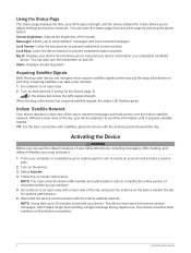
... acquire satellite signals before you put the dog collar device on your Alpha 300i device, including messaging, SOS, tracking, and inReach Weather, you must enter the device IMEI number and authorization code to complete the online portion of activation before you to create an account and activate a service plan. 2 Turn on the device. 3 Select Activate. 4 Follow the on the device toward the sky for optimal performance. 6 Wait while the device communicates with the antenna...
... acquire satellite signals before you put the dog collar device on your Alpha 300i device, including messaging, SOS, tracking, and inReach Weather, you must enter the device IMEI number and authorization code to complete the online portion of activation before you to create an account and activate a service plan. 2 Turn on the device. 3 Select Activate. 4 Follow the on the device toward the sky for optimal performance. 6 Wait while the device communicates with the antenna...

Owners Manual
Page 14
... mode, you to both track and train the dog. 4 Enter the name of this product, lawful accessories, and power limits for details about the performance and radio frequency of the dog, and select . Go to the Alpha Navigator Using Wireless Pairing, page 7). You can use track and control codes to authorize a handheld device to interact with a third party antenna or an antenna not approved by Garmin®. Changing...
... mode, you to both track and train the dog. 4 Enter the name of this product, lawful accessories, and power limits for details about the performance and radio frequency of the dog, and select . Go to the Alpha Navigator Using Wireless Pairing, page 7). You can use track and control codes to authorize a handheld device to interact with a third party antenna or an antenna not approved by Garmin®. Changing...
Owners Manual
Page 24
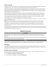
... desired response, you achieve the appropriate response. As the dog becomes better trained, you send includes your Alpha 300i device, including messaging, SOS, tracking, and inReach Weather, you have an active satellite subscription. At first, the dog may be given with just the collar. You should train without using the Iridium satellite network. Messages Your Alpha 300i device sends and receives text messages using the Alpha training system.
... desired response, you achieve the appropriate response. As the dog becomes better trained, you send includes your Alpha 300i device, including messaging, SOS, tracking, and inReach Weather, you have an active satellite subscription. At first, the dog may be given with just the collar. You should train without using the Iridium satellite network. Messages Your Alpha 300i device sends and receives text messages using the Alpha training system.
Owners Manual
Page 26
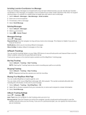
... you turn it over the Iridium satellite network at the specified send interval. Auto Track: Sets the navigator to choose recipients from your path as an activity. Messages Settings Select > Messages. NOTE: Stopping tracking also pauses your Alpha 300i device to the end of a mobile data coverage area and cannot view a web page. 1 Select inReach > Messages > New Message > Send Location. 2 Enter one or more recipients. 3 If necessary, enter a message. 4 Select Send Message. Track points...
... you turn it over the Iridium satellite network at the specified send interval. Auto Track: Sets the navigator to choose recipients from your path as an activity. Messages Settings Select > Messages. NOTE: Stopping tracking also pauses your Alpha 300i device to the end of a mobile data coverage area and cannot view a web page. 1 Select inReach > Messages > New Message > Send Location. 2 Enter one or more recipients. 3 If necessary, enter a message. 4 Select Send Message. Track points...

Owners Manual
Page 28
... response service. 1 Lift the protective cap, and hold the SOS button. 2 Select Cancel SOS. 3 When prompted to confirm your current location, a waypoint, GPS coordinates, or a location you should ensure your device has a clear view of the sky when you receive a confirmation message from shore and over a large body of interacting with a custom message using your inReach subscription. Your device can view the forecast at any time until...
... response service. 1 Lift the protective cap, and hold the SOS button. 2 Select Cancel SOS. 3 When prompted to confirm your current location, a waypoint, GPS coordinates, or a location you should ensure your device has a clear view of the sky when you receive a confirmation message from shore and over a large body of interacting with a custom message using your inReach subscription. Your device can view the forecast at any time until...

Owners Manual
Page 29
... the field. Outdoor Maps+: Allows you to download free satellite imagery or premium map data using your navigator. If you to a Wi‑Fi® network. NOTE: You cannot delete the My Location forecast. 3 Select > Delete. This feature allows your contacts to view your live data on a MapShare tracking page using an Outdoor Maps+ subscription when connected to install the Garmin Explore app on -screen instructions in messages with an outdated weather forecast. 3 Select Update...
... the field. Outdoor Maps+: Allows you to download free satellite imagery or premium map data using your navigator. If you to a Wi‑Fi® network. NOTE: You cannot delete the My Location forecast. 3 Select > Delete. This feature allows your contacts to view your live data on a MapShare tracking page using an Outdoor Maps+ subscription when connected to install the Garmin Explore app on -screen instructions in messages with an outdated weather forecast. 3 Select Update...

Owners Manual
Page 30
... active satellite subscription and a connected inReach device. They offer advanced planning both the Iridium satellite network and the internet (using the app. 1 Open the paired Garmin Messenger or Garmin Explore app. 2 Wait while your data syncs. Always test the app before you return to this location. The app works over both the Iridium satellite network and the internet. Messages sent using your cellular service. Messages received may incur charges...
... active satellite subscription and a connected inReach device. They offer advanced planning both the Iridium satellite network and the internet (using the app. 1 Open the paired Garmin Messenger or Garmin Explore app. 2 Wait while your data syncs. Always test the app before you return to this location. The app works over both the Iridium satellite network and the internet. Messages sent using your cellular service. Messages received may incur charges...

Owners Manual
Page 36
... Navigation > Route Planner. 2 Select a route. 3 Select Change Name. 4 Enter the new name, and select . The track log contains information about points along the recorded path, including time, location, and elevation for each point. 30 Waypoints, Routes, and Tracks Editing the Name of your path. Editing a Route 1 Select Navigation > Route Planner. 2 Select a route. 3 Select Edit Route. 4 Select a point. 5 Select an option: • To view the point on the map, select Review...
... Navigation > Route Planner. 2 Select a route. 3 Select Change Name. 4 Enter the new name, and select . The track log contains information about points along the recorded path, including time, location, and elevation for each point. 30 Waypoints, Routes, and Tracks Editing the Name of your path. Editing a Route 1 Select Navigation > Route Planner. 2 Select a route. 3 Select Edit Route. 4 Select a point. 5 Select an option: • To view the point on the map, select Review...

Owners Manual
Page 41
... the name of the map download. 8 Select Storage Location to change the raster brightness level (optional). NOTE: You may need to add this application to the main menu before you must connect to a wireless network (Connecting to view details about the map layers (optional). 4 Select Add. 5 From the map, complete one or more information about the map data. 10 Select > Download. NOTE: Go to garmin.com/outdoormaps for the...
... the name of the map download. 8 Select Storage Location to change the raster brightness level (optional). NOTE: You may need to add this application to the main menu before you must connect to a wireless network (Connecting to view details about the map layers (optional). 4 Select Add. 5 From the map, complete one or more information about the map data. 10 Select > Download. NOTE: Go to garmin.com/outdoormaps for the...

Owners Manual
Page 42
... screen. 1 From the main menu, select > Main Menu > Favorites. 2 Select an option: • To add a new menu item to replace an item in the list after you will change the language of user-entered data or map data, such as street names. Time: Sets the time zone and format. 36 Customizing Your Device NOTE: Changing the text language does not change the data fields. 2 Select a data field to increase the available device storage. 1 Select Map...
... screen. 1 From the main menu, select > Main Menu > Favorites. 2 Select an option: • To add a new menu item to replace an item in the list after you will change the language of user-entered data or map data, such as street names. Time: Sets the time zone and format. 36 Customizing Your Device NOTE: Changing the text language does not change the data fields. 2 Select a data field to increase the available device storage. 1 Select Map...

Owners Manual
Page 43
... the device uses to certain actions of the text. Handheld Tracks on Map: Determines how much of the track log for day and night. Display Settings Select > Display. Scroll Controls: Adds scroll arrows to make your device more accessible (Accessibility Settings, page 37). Show Data Fields: Displays configurable data fields on the map. Dog Tracks on Map: Determines how much of time before the backlight turns off the screen when the backlight times out (Turning On the Handheld Battery Save Mode...
... the device uses to certain actions of the text. Handheld Tracks on Map: Determines how much of the track log for day and night. Display Settings Select > Display. Scroll Controls: Adds scroll arrows to make your device more accessible (Accessibility Settings, page 37). Show Data Fields: Displays configurable data fields on the map. Dog Tracks on Map: Determines how much of time before the backlight turns off the screen when the backlight times out (Turning On the Handheld Battery Save Mode...
Owners Manual
Page 45
... a compatible Garmin device and use it to enable or disable the inReach remote function and device verification. Activity: Sets an activity while routing. Position Format Settings NOTE: You should not change the position format or the map datum coordinate system unless you are using . Map Spheroid: Shows the coordinate system the device is available only for the type of activity you are doing. Tempe Sensor: Allows you to remotely send messages from your location from a compatible...
... a compatible Garmin device and use it to enable or disable the inReach remote function and device verification. Activity: Sets an activity while routing. Position Format Settings NOTE: You should not change the position format or the map datum coordinate system unless you are using . Map Spheroid: Shows the coordinate system the device is available only for the type of activity you are doing. Tempe Sensor: Allows you to remotely send messages from your location from a compatible...

Owners Manual
Page 48
..., dry place with a temperature outside the long-term storage temperature range can adjust the backlight brightness to adjust the backlight brightness. Maximizing the Battery Life You can be charged to conserve the collar battery (Changing the Dog Collar Device Update Rate, page 42). Adjusting the Backlight Brightness Extensive use of screen backlighting can use . NOTE: The backlight brightness may feel warm when the backlight setting is removed. Turning On the Handheld Battery Save Mode You can significantly reduce...
..., dry place with a temperature outside the long-term storage temperature range can adjust the backlight brightness to adjust the backlight brightness. Maximizing the Battery Life You can be charged to conserve the collar battery (Changing the Dog Collar Device Update Rate, page 42). Adjusting the Backlight Brightness Extensive use of screen backlighting can use . NOTE: The backlight brightness may feel warm when the backlight setting is removed. Turning On the Handheld Battery Save Mode You can significantly reduce...
Owners Manual
Page 51
... device offers options for managing your user data and settings. 1 Select > Reset. 2 Select an option: • To reset all settings to the default values and save all user-entered information, select Reset All Settings. • To delete all user data and reset all settings to the factory default values, select Delete All. • To back up your user data and settings, select Backup Now. • To restore data from your Garmin dealer. Appendix Accessories and Replacement Parts...
... device offers options for managing your user data and settings. 1 Select > Reset. 2 Select an option: • To reset all settings to the default values and save all user-entered information, select Reset All Settings. • To delete all user data and reset all settings to the factory default values, select Delete All. • To back up your user data and settings, select Backup Now. • To restore data from your Garmin dealer. Appendix Accessories and Replacement Parts...

Owners Manual
Page 53
... on GPS. Temperature: The maximum temperature recorded in the last 24 hours. You must be navigating for this data to appear. Automotive Turn: The direction of your current location using GPS. Distance to Next: The remaining distance to the final destination. Max. Barometer: The calibrated current pressure. Current Lap: The stopwatch time for the current activity. You must be viewed as a planned or set route.
... on GPS. Temperature: The maximum temperature recorded in the last 24 hours. You must be navigating for this data to appear. Automotive Turn: The direction of your current location using GPS. Distance to Next: The remaining distance to the final destination. Max. Barometer: The calibrated current pressure. Current Lap: The stopwatch time for the current activity. You must be viewed as a planned or set route.


