
Technical Specifications
Page 3
... Receiver ...5 1.5.4.2 Acquisition Times ...5 1.5.4.3 Sentence Rate ...5 1.5.4.4 Accuracy ...5 1.5.5 Interfaces...5 1.5.5.1 Port 1 ...5 1.5.5.2 Port 2 ...5 1.5.5.3 PPS...6 1.5.5.4 Power Control ...6 2 GPS 16x Wiring and Pinouts 7 2.1 GPS 16x Pinout ...7 2.2 GPS 16x Wiring Diagrams...8 3 Mechanical Characteristics & Mounting 9 3.1 GPS 16x Flush Mount ...9 3.2 GPS 16x Optional Magnetic Mount ...10 4 Software Interface...11 4.1 Received NMEA 0183 Sentences ...11 4.1.1 Almanac Information (ALM)...11 4.1.2 Sensor Initialization Information (PGRMI) ...12 4.1.3 Sensor Configuration Information...
... Receiver ...5 1.5.4.2 Acquisition Times ...5 1.5.4.3 Sentence Rate ...5 1.5.4.4 Accuracy ...5 1.5.5 Interfaces...5 1.5.5.1 Port 1 ...5 1.5.5.2 Port 2 ...5 1.5.5.3 PPS...6 1.5.5.4 Power Control ...6 2 GPS 16x Wiring and Pinouts 7 2.1 GPS 16x Pinout ...7 2.2 GPS 16x Wiring Diagrams...8 3 Mechanical Characteristics & Mounting 9 3.1 GPS 16x Flush Mount ...9 3.2 GPS 16x Optional Magnetic Mount ...10 4 Software Interface...11 4.1 Received NMEA 0183 Sentences ...11 4.1.1 Almanac Information (ALM)...11 4.1.2 Sensor Initialization Information (PGRMI) ...12 4.1.3 Sensor Configuration Information...
Technical Specifications
Page 4
......29 Appendix D: Sensor Configuration Software 30 Downloading the Sensor Configuration Software...30 Selecting a Model ...30 Connecting to the Sensor ...30 Menus ...31 File Menu...31 Comm Menu ...31 Config Menu ...31 View Menu ...32 Help Menu ...32 LIST OF TABLES AND FIGURES Table 1: GPS 16x Wire Pinout ...7 Figure 1: Computer Serial Port Interconnection...8 Figure 2: PDA Serial Port Interconnection...8 Figure 3: Basic NMEA Device Interconnection...8 Figure 4: GPS 16x Flush Mount Dimensions ...9 Figure 5: Optional GPS 16x Magnetic Mount...10 Table 2: NMEA 0183 Output Sentence Order and...
......29 Appendix D: Sensor Configuration Software 30 Downloading the Sensor Configuration Software...30 Selecting a Model ...30 Connecting to the Sensor ...30 Menus ...31 File Menu...31 Comm Menu ...31 Config Menu ...31 View Menu ...32 Help Menu ...32 LIST OF TABLES AND FIGURES Table 1: GPS 16x Wire Pinout ...7 Figure 1: Computer Serial Port Interconnection...8 Figure 2: PDA Serial Port Interconnection...8 Figure 3: Basic NMEA Device Interconnection...8 Figure 4: GPS 16x Flush Mount Dimensions ...9 Figure 5: Optional GPS 16x Magnetic Mount...10 Table 2: NMEA 0183 Output Sentence Order and...

Technical Specifications
Page 5
... these products at your authority to operate this device under Part 15 regulations. 190-00228-08 GPS 16x Technical Specifications Page 1 Rev. Although the GPS 16x is a precision electronic NAVigation AID (NAVAID), any user-serviceable parts. To reduce the risk, carefully review and understand all available navigation sources including the information from the GPS unit. • Consult the dealer or an experienced radio/TV technician for help. However, there...
... these products at your authority to operate this device under Part 15 regulations. 190-00228-08 GPS 16x Technical Specifications Page 1 Rev. Although the GPS 16x is a precision electronic NAVigation AID (NAVAID), any user-serviceable parts. To reduce the risk, carefully review and understand all available navigation sources including the information from the GPS unit. • Consult the dealer or an experienced radio/TV technician for help. However, there...
Technical Specifications
Page 6
... tracking number clearly on the outside of purchase for shipping instructions and an RMA tracking number. 1.2 LIMITED WARRANTY This Garmin product is warranted to be free from defects in the area of intended distribution. Such repairs or replacement will not replace missing components from Garmin. Garmin retains the exclusive right to be used for your local Garmin authorized dealer or call Garmin Product Support for warranty repairs...
... tracking number clearly on the outside of purchase for shipping instructions and an RMA tracking number. 1.2 LIMITED WARRANTY This Garmin product is warranted to be free from defects in the area of intended distribution. Such repairs or replacement will not replace missing components from Garmin. Garmin retains the exclusive right to be used for your local Garmin authorized dealer or call Garmin Product Support for warranty repairs...

Technical Specifications
Page 7
... satellite orbital parameters, last-known position, date, and time. to 5-meter position accuracy (see section 4.1 Received NMEA 0183 Sentences). • Highly accurate one -second navigation updates, and low power consumption. Pulse width is configurable in other Garmin GPS receivers, the GPS 16x tracks multiple satellites at most systems that expect NMEA 0183 data from 20 ms to customize the NMEA 0183 output (see section 1.5 Technical Specifications). • Compact, rugged design ideal for binary format data output...
... satellite orbital parameters, last-known position, date, and time. to 5-meter position accuracy (see section 4.1 Received NMEA 0183 Sentences). • Highly accurate one -second navigation updates, and low power consumption. Pulse width is configurable in other Garmin GPS receivers, the GPS 16x tracks multiple satellites at most systems that expect NMEA 0183 data from 20 ms to customize the NMEA 0183 output (see section 1.5 Technical Specifications). • Compact, rugged design ideal for binary format data output...
Technical Specifications
Page 9
...; Cold: Approx. 45 seconds 1.5.4.3 Sentence Rate 1 second default; 1.5.4 GPS Performance 1.5.4.1 Receiver WAAS Enabled® GPS receiver continuously tracks and uses multiple satellites to 900 seconds in 1-second increments 1.5.4.4 Accuracy • GPS Standard Positioning Service (SPS) Position: NMEA 0183 output interval configurable from 1 to compute and update your position. 1.5.4.2 Acquisition Times • Reacquisition: Less than 2 seconds • Hot: Approx. 1 second (all data known) • Warm: Approx. 38 seconds (initial...
...; Cold: Approx. 45 seconds 1.5.4.3 Sentence Rate 1 second default; 1.5.4 GPS Performance 1.5.4.1 Receiver WAAS Enabled® GPS receiver continuously tracks and uses multiple satellites to 900 seconds in 1-second increments 1.5.4.4 Accuracy • GPS Standard Positioning Service (SPS) Position: NMEA 0183 output interval configurable from 1 to compute and update your position. 1.5.4.2 Acquisition Times • Reacquisition: Less than 2 seconds • Hot: Approx. 1 second (all data known) • Warm: Approx. 38 seconds (initial...
Technical Specifications
Page 11
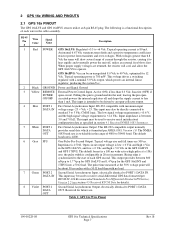
.... This voltage drives a switching regulator with maximum input voltage range -25 < Vdc < 25. Power and Signal Ground External Power Control Input. RS-232 compatible with a nominal 5.0 Vdc output, which is configurable in the cable assembly. This input may also be used to operate. Input impedance is 4800. Table 1: GPS 16x Wire Pinout 190-00228-08 GPS 16x Technical Specifications Page 7 Rev. With voltages greater than 0.3 Vdc. First Serial Asynchronous Input. This input may be an unregulated...
.... This voltage drives a switching regulator with maximum input voltage range -25 < Vdc < 25. Power and Signal Ground External Power Control Input. RS-232 compatible with a nominal 5.0 Vdc output, which is configurable in the cable assembly. This input may also be used to operate. Input impedance is 4800. Table 1: GPS 16x Wire Pinout 190-00228-08 GPS 16x Technical Specifications Page 7 Rev. With voltages greater than 0.3 Vdc. First Serial Asynchronous Input. This input may be an unregulated...
Technical Specifications
Page 15
... by the GPS sensor must be output on the National Marine Electronics Association's NMEA 0183 ASCII interface specification. 4 SOFTWARE INTERFACE The GPS 16x series products interface protocol design on COM1 is based on the COM1 port; The COM2 port can be null or any number when sending almanac to transmitting navigation information as 3D instead of Garmin proprietary sentences. This field can receive differential GPS (DGPS) correction data using the convention...
... by the GPS sensor must be output on the National Marine Electronics Association's NMEA 0183 ASCII interface specification. 4 SOFTWARE INTERFACE The GPS 16x series products interface protocol design on COM1 is based on the COM1 port; The COM2 port can be null or any number when sending almanac to transmitting navigation information as 3D instead of Garmin proprietary sentences. This field can receive differential GPS (DGPS) correction data using the convention...

Technical Specifications
Page 16
... baud rate and PPS mode. Configuration parameters are no errors are detected. The GPS sensor will echo this sentence by sending $PGRMCE to the GPS sensor. $PGRMC,,,,,,,,,,,,,,*hh Fix mode, A = Automatic, 3 = 3D exclusively Altitude above/below mean sea level, -1500.0 to 18000.0 meters Earth datum index. 4.1.2 Sensor Initialization Information (PGRMI) The $PGRMI sentence provides information used to initialize the GPS sensor's set position and time used for backwards compatibility) PPS...
... baud rate and PPS mode. Configuration parameters are no errors are detected. The GPS sensor will echo this sentence by sending $PGRMCE to the GPS sensor. $PGRMC,,,,,,,,,,,,,,*hh Fix mode, A = Automatic, 3 = 3D exclusively Altitude above/below mean sea level, -1500.0 to 18000.0 meters Earth datum index. 4.1.2 Sensor Initialization Information (PGRMI) The $PGRMI sentence provides information used to initialize the GPS sensor's set position and time used for backwards compatibility) PPS...

Technical Specifications
Page 17
... data format to the GPS sensor. $PGRMC1,,,,,,,,,,,,,,*hh NMEA 0183 output time 1-900 (sec) Binary Output Data, 1 = Off, 2 = On. If either the target sentence mode field or the target sentence description field is allowed (e.g., $PGRMO,,3), or the mode field may contain from 1 to configure the GPS sensor operation. Then follow by sending the sentence "$PGRMI,,,,,,,R" (see section 4.1.2 Sensor Initialization Information (PGRMI). The following eight-byte data stream to temporarily change to update the GPS 16x series...
... data format to the GPS sensor. $PGRMC1,,,,,,,,,,,,,,*hh NMEA 0183 output time 1-900 (sec) Binary Output Data, 1 = Off, 2 = On. If either the target sentence mode field or the target sentence description field is allowed (e.g., $PGRMO,,3), or the mode field may contain from 1 to configure the GPS sensor operation. Then follow by sending the sentence "$PGRMI,,,,,,,R" (see section 4.1.2 Sensor Initialization Information (PGRMI). The following eight-byte data stream to temporarily change to update the GPS 16x series...

Technical Specifications
Page 19
... output. 4.2.2 Transmitted Time The GPS sensor outputs Coordinated Universal Time (UTC) date and time of day in National Institute of Standards and Technology Special Publication 432 (Revised 1990). Almanac transmission can be found in section 4.1.1 Almanac Information (ALM). 4.2.4 Global Positioning System Fix Data (GGA) $GPGGA,,,,,,,,,,M,,M,,*hh UTC time of position fix, hhmmss format Latitude, ddmm.mmmm format (leading zeros will be transmitted) Latitude hemisphere, N or S Longitude, dddmm.mmmm format...
... output. 4.2.2 Transmitted Time The GPS sensor outputs Coordinated Universal Time (UTC) date and time of day in National Institute of Standards and Technology Special Publication 432 (Revised 1990). Almanac transmission can be found in section 4.1.1 Almanac Information (ALM). 4.2.4 Global Positioning System Fix Data (GGA) $GPGGA,,,,,,,,,,M,,M,,*hh UTC time of position fix, hhmmss format Latitude, ddmm.mmmm format (leading zeros will be transmitted) Latitude hemisphere, N or S Longitude, dddmm.mmmm format...

Technical Specifications
Page 20
... will be transmitted) Mode indicator (only output if NMEA 0183 version 2.30 active), A = Autonomous, D = Differential, E = Estimated, N = Data not valid 190-00228-08 GPS 16x Technical Specifications Page 16 Rev. 4.2.5 GPS DOP and Active Satellites (GSA) $GPGSA,,,,,,,,,,,,,,,,,*hh Mode, M = Manual, A = Automatic Fix type, 1 = Not available, 2 = 2D, 3 = 3D PRN number, 01 to 32, of satellite used in solution, up to 12 transmitted (leading zeros will be transmitted) Position dilution of precision...
... will be transmitted) Mode indicator (only output if NMEA 0183 version 2.30 active), A = Autonomous, D = Differential, E = Estimated, N = Data not valid 190-00228-08 GPS 16x Technical Specifications Page 16 Rev. 4.2.5 GPS DOP and Active Satellites (GSA) $GPGSA,,,,,,,,,,,,,,,,,*hh Mode, M = Manual, A = Automatic Fix type, 1 = Not available, 2 = 2D, 3 = 3D PRN number, 01 to 32, of satellite used in solution, up to 12 transmitted (leading zeros will be transmitted) Position dilution of precision...
Technical Specifications
Page 21
... field is not used on this model and is used by the GPS sensor. B 4.2.9 Geographic Position (GLL) $GPGLL,,,,,,,*hh Latitude, ddmm.mmmm format (leading zeros will be transmitted) Latitude hemisphere, N or S Longitude, dddmm.mmmm format (leading zeros will be transmitted) Longitude hemisphere, E or W UTC time of position fix, hhmmss format Status, A = Valid position, V = NAV receiver warning Mode indicator (only output if NMEA 0183 version 2.30 active), A = Autonomous, D = Differential, E = Estimated, N = Data not valid 4.2.10 Estimated Error Information...
... field is not used on this model and is used by the GPS sensor. B 4.2.9 Geographic Position (GLL) $GPGLL,,,,,,,*hh Latitude, ddmm.mmmm format (leading zeros will be transmitted) Latitude hemisphere, N or S Longitude, dddmm.mmmm format (leading zeros will be transmitted) Longitude hemisphere, E or W UTC time of position fix, hhmmss format Status, A = Valid position, V = NAV receiver warning Mode indicator (only output if NMEA 0183 version 2.30 active), A = Autonomous, D = Differential, E = Estimated, N = Data not valid 4.2.10 Estimated Error Information...

Technical Specifications
Page 22
... as described in RTCM SC-104 format, with the GPS 16x series products by sending the appropriate configuration sentence to the GPS sensor as described in $PGRMC section 4.1.3 Sensor Configuration Information (PGRMC), field . 4.5 RECEIVED RTCM DATA Position accuracy of the selected baud rate, the information transmitted by the GPS sensor is provided for backwards compatibility) DGPS fix source (R = RTCM, W = WAAS, N = Non-DGPS Fix) DGPS mode, A = Automatic, W = WAAS Only, R = RTCM Only...
... as described in RTCM SC-104 format, with the GPS 16x series products by sending the appropriate configuration sentence to the GPS sensor as described in $PGRMC section 4.1.3 Sensor Configuration Information (PGRMC), field . 4.5 RECEIVED RTCM DATA Position accuracy of the selected baud rate, the information transmitted by the GPS sensor is provided for backwards compatibility) DGPS fix source (R = RTCM, W = WAAS, N = Non-DGPS Fix) DGPS mode, A = Automatic, W = WAAS Only, R = RTCM Only...
Technical Specifications
Page 26
... information. int fix; Position Record - 0x10 - 0x33 - 0x40 - float eph; long grmn_days; } cpo_pvt_data; 190-00228-08 GPS 16x Technical Specifications Page 22 Rev. Note: If RTCM-104 differential data is the first byte of GPS 16xLVS and GPS 16xHVS. float epv; float alt_vel; The second record contains receiver measurement information. The fourth byte is sent to the GPS sensor, the board will reset the Garmin Binary Output Data...
... information. int fix; Position Record - 0x10 - 0x33 - 0x40 - float eph; long grmn_days; } cpo_pvt_data; 190-00228-08 GPS 16x Technical Specifications Page 22 Rev. Note: If RTCM-104 differential data is the first byte of GPS 16xLVS and GPS 16xHVS. float epv; float alt_vel; The second record contains receiver measurement information. The fourth byte is sent to the GPS sensor, the board will reset the Garmin Binary Output Data...

Technical Specifications
Page 27
... position error (meters) Position error, horizontal (meters) Position error, vertical (meters) 0 = no fix; 1 = no fix; 2 = 2D; 3 = 3D; 4 = 2D differential; 5 = 3D differential; 6 and greater = not defined GPS time of week (sec) Latitude (radians) Longitude (radians) Longitude velocity (meters/second) Latitude velocity (meters/second) Altitude velocity (meters/ second) height (mean sea level) (meters) UTC leap seconds Garmin days (days since December 31, 1989) Satellite Data Record The satellite data has...
... position error (meters) Position error, horizontal (meters) Position error, vertical (meters) 0 = no fix; 1 = no fix; 2 = 2D; 3 = 3D; 4 = 2D differential; 5 = 3D differential; 6 and greater = not defined GPS time of week (sec) Latitude (radians) Longitude (radians) Longitude velocity (meters/second) Latitude velocity (meters/second) Altitude velocity (meters/ second) height (mean sea level) (meters) UTC leap seconds Garmin days (days since December 31, 1989) Satellite Data Record The satellite data has...

Technical Specifications
Page 29
...-08 GPS 16x Technical Specifications Page 25 Rev. Garmin Binary Format Review To download the ephemeris data, you must remove the escaped DLE bytes. Checksum Packet Delimiter End of the default NMEA output format. In order to interpret these packets properly, one must first command the unit to the Sample C Code fragment on by an ETX byte means that unit is in Garmin binary format, transmitted and received packets...
...-08 GPS 16x Technical Specifications Page 25 Rev. Garmin Binary Format Review To download the ephemeris data, you must remove the escaped DLE bytes. Checksum Packet Delimiter End of the default NMEA output format. In order to interpret these packets properly, one must first command the unit to the Sample C Code fragment on by an ETX byte means that unit is in Garmin binary format, transmitted and received packets...
Technical Specifications
Page 34
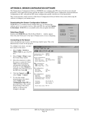
... Main Interface Screen for the program. Select Comm > Setup to NMEA Mode (or press the F10 key). 2. Select Config > Switch to open the Comm Setup window. 3. Click OK. 4. This section provides a brief overview of the GPS 16x. Select the radio button next to the right. 190-00228-08 GPS 16x Technical Specifications Page 30 Rev. This is included in the software update download. window appears. To configure your Garmin sensor. Select Auto...
... Main Interface Screen for the program. Select Comm > Setup to NMEA Mode (or press the F10 key). 2. Select Config > Switch to open the Comm Setup window. 3. Click OK. 4. This section provides a brief overview of the GPS 16x. Select the radio button next to the right. 190-00228-08 GPS 16x Technical Specifications Page 30 Rev. This is included in the software update download. window appears. To configure your Garmin sensor. Select Auto...

Technical Specifications
Page 35
... the fields in the File Menu work like cycling the power. Click Reset Unit to perform a reset on the unit, much like most Windows-based programs. Comm Menu The Comm (Communication) Menu allows you to configure the sensor as connect to change or view the configuration. Connect: Select Connect to connect to the sensor in the box to open, save, and print sensor configurations. If the sentence is connected from the nonvolatile memory. Menus File Menu The File Menu...
... the fields in the File Menu work like cycling the power. Click Reset Unit to perform a reset on the unit, much like most Windows-based programs. Comm Menu The Comm (Communication) Menu allows you to configure the sensor as connect to change or view the configuration. Connect: Select Connect to connect to the sensor in the box to open, save, and print sensor configurations. If the sentence is connected from the nonvolatile memory. Menus File Menu The File Menu...

Technical Specifications
Page 36
... by the sensor. or its subsidiaries Garmin International, Inc. 1200 East 151st Street, Olathe, Kansas 66062, U.S.A. B 190-00228-08 GPS 16x Technical Specifications Page 32 Rev. Switch to NMEA Mode (F10): Switches the unit to Garmin Mode. Switch to Garmin Mode (F11): Switches the unit to NMEA Mode. Select Update Software and then select the file using the Open dialog box. B For the latest free software updates (excluding map data) throughout the life of your updated configuration programming to view the NMEA sentences...
... by the sensor. or its subsidiaries Garmin International, Inc. 1200 East 151st Street, Olathe, Kansas 66062, U.S.A. B 190-00228-08 GPS 16x Technical Specifications Page 32 Rev. Switch to NMEA Mode (F10): Switches the unit to Garmin Mode. Switch to Garmin Mode (F11): Switches the unit to NMEA Mode. Select Update Software and then select the file using the Open dialog box. B For the latest free software updates (excluding map data) throughout the life of your updated configuration programming to view the NMEA sentences...

