User Manual
Page 3
GPS navigational software for ASUS R300 UK English August, 2007 (1.0) Copyright note The product and the information contained herein may not be changed at any form either electronically or mechanically, ... parts thereof may be reproduced or transmitted in any time without the express written consent of Northern Ireland Norway: © Norwegian Mapping Authority, Public Roads Administration / Mapsolutions Switzerland: © Swisstopo The Netherlands: Topografische ondergrond Copyright © dienst voor het kadaster en de openbare registers, Apeldorn All rights reserved...
GPS navigational software for ASUS R300 UK English August, 2007 (1.0) Copyright note The product and the information contained herein may not be changed at any form either electronically or mechanically, ... parts thereof may be reproduced or transmitted in any time without the express written consent of Northern Ireland Norway: © Norwegian Mapping Authority, Public Roads Administration / Mapsolutions Switzerland: © Swisstopo The Netherlands: Topografische ondergrond Copyright © dienst voor het kadaster en de openbare registers, Apeldorn All rights reserved...
User Manual
Page 31
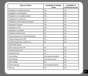
... a POI Navigating to coordinates Creating a multi-point route Saving a map point as a Favorite destination Saving a map point as a POI Saving a map point as a location of a Road Safety Camera Mark a map point with a Pin Saving the active route Saving track logs Visual settings Sound settings Route settings Regional settings Warnings Available in...
... a POI Navigating to coordinates Creating a multi-point route Saving a map point as a Favorite destination Saving a map point as a POI Saving a map point as a location of a Road Safety Camera Mark a map point with a Pin Saving the active route Saving track logs Visual settings Sound settings Route settings Regional settings Warnings Available in...

User Manual
Page 34
... �s��t�o�p��f�a��c�e�s� your manoeuvre at a distance, Asus GO zooms out and lowers the view angle to show you the road in front of you. 2.1.4.3 Switching between the 2D and 3D modes You can automatically rotate, scale and tilt... the map and give you the optimal view: • When you can turn is available, Asus GO always rotates the map �s�...
... �s��t�o�p��f�a��c�e�s� your manoeuvre at a distance, Asus GO zooms out and lowers the view angle to show you the road in front of you. 2.1.4.3 Switching between the 2D and 3D modes You can automatically rotate, scale and tilt... the map and give you the optimal view: • When you can turn is available, Asus GO always rotates the map �s�...
User Manual
Page 36
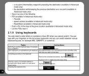
... as one of the following • POI (available in Advanced mode only) • Favorite • speed camera (available in Advanced mode only) • Road Block (available in Advanced mode only) • Push a Pin in the map at the given location (available in Advanced mode only) • List the ...string. Latin keyboard to another keyboard type, for example ABC, QWERTY, or numerical. You can switch between a surname and a family name or in Asus GO when you need to enter letters or numbers in multi-word street names Finalising the keyboard entry Hold the button to enter data. Entering...
... as one of the following • POI (available in Advanced mode only) • Favorite • speed camera (available in Advanced mode only) • Road Block (available in Advanced mode only) • Push a Pin in the map at the given location (available in Advanced mode only) • List the ...string. Latin keyboard to another keyboard type, for example ABC, QWERTY, or numerical. You can switch between a surname and a family name or in Asus GO when you need to enter letters or numbers in multi-word street names Finalising the keyboard entry Hold the button to enter data. Entering...
User Manual
Page 37
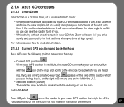
...set here when you drive at the next junction. ing. Lock-On-Road Asus GO puts the icon on the road or to your exact GPS position that might be flat so you can see the road in front of the road on which you are driving, that you made for navigation preferences. ...37 For instructions on how to enableSmart Zoom. 2.1.6.2 Current GPS position and Lock-On-Road Asus GO uses the following position markers on the map: • Current GPS position: When your GPS position is a lot more than just a usual automatic zoom...
...set here when you drive at the next junction. ing. Lock-On-Road Asus GO puts the icon on the road or to your exact GPS position that might be flat so you can see the road in front of the road on which you are driving, that you made for navigation preferences. ...37 For instructions on how to enableSmart Zoom. 2.1.6.2 Current GPS position and Lock-On-Road Asus GO uses the following position markers on the map: • Current GPS position: When your GPS position is a lot more than just a usual automatic zoom...
User Manual
Page 38
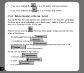
... it visible at the selected point on which you can save the location of a 3D map view. The Cursor menu appears and you are driving. Asus GO displays the Cursor with a red dot and radiating red circles to make it is in a route (tap • the destination of a route (tap ) if... starting point of a route (tap ) • a via point in the background of the Cursor as one of the following: . When the Cursor is on the road on the map.
... it visible at the selected point on which you can save the location of a 3D map view. The Cursor menu appears and you are driving. Asus GO displays the Cursor with a red dot and radiating red circles to make it is in a route (tap • the destination of a route (tap ) if... starting point of a route (tap ) • a via point in the background of the Cursor as one of the following: . When the Cursor is on the road on the map.
User Manual
Page 39
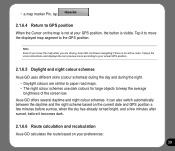
...the turn preview icons according to your preferences: 39 Note Even if you are similar to paper road maps. • The night colour schemes use dark colours for large objects to the GPS position. Asus GO offers several daytime and night colour schemes. Tap it becomes dark. 2.1.6.6 Route calculation and recalculation.... It can also switch automatically between the daytime and the night scheme based on your actual GPS position. 2.1.6.5 Daylight and night colour schemes Asus GO uses different skins (colour schemes) during the day and during the night. • Daylight colours are driving...
...the turn preview icons according to your preferences: 39 Note Even if you are similar to paper road maps. • The night colour schemes use dark colours for large objects to the GPS position. Asus GO offers several daytime and night colour schemes. Tap it becomes dark. 2.1.6.6 Route calculation and recalculation.... It can also switch automatically between the daytime and the night scheme based on your actual GPS position. 2.1.6.5 Daylight and night colour schemes Asus GO uses different skins (colour schemes) during the day and during the night. • Daylight colours are driving...
User Manual
Page 41
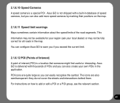
...your local dealer) or may not be available for all roads in the application. For instructions on the map. 2.1.6.11 Speed limit warnings Maps sometimes contain information about the speed limits of interest (POI) is a special POI . Asus GO is not shipped with thousands of POIs and you ...exceed the current limit. 2.1.6.12 POI (Points of Interest) A point of the road segments. POI icons are also semitransparent: they do not cover the streets and ...
...your local dealer) or may not be available for all roads in the application. For instructions on the map. 2.1.6.11 Speed limit warnings Maps sometimes contain information about the speed limits of interest (POI) is a special POI . Asus GO is not shipped with thousands of POIs and you ...exceed the current limit. 2.1.6.12 POI (Points of Interest) A point of the road segments. POI icons are also semitransparent: they do not cover the streets and ...
User Manual
Page 46
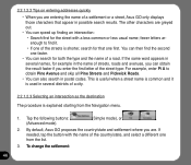
...search in possible search results. You can then find it is used in several names, for the street with the name of a road. By default, Asus GO proposes the country/state and settlement where you are. 2.2.1.2.2 Tips on entering addresses quickly • When you are entering the ...name of a settlement or a street, Asus GO only displays those characters that one first. If the same word appears in several districts of a city. 2.2.1.2.3 Selecting an intersection as the...
...search in possible search results. You can then find it is used in several names, for the street with the name of a road. By default, Asus GO proposes the country/state and settlement where you are. 2.2.1.2.2 Tips on entering addresses quickly • When you are entering the ...name of a settlement or a street, Asus GO only displays those characters that one first. If the same word appears in several districts of a city. 2.2.1.2.3 Selecting an intersection as the...

User Manual
Page 60
No. However, Asus GO provides much more than regular paper maps: you can appear on the map; Related topics Yes Tap it to paper road maps. No - 60 The most important and most often used screen of Asus GO is primarily intended for land navigation. The figures below show what can customise the look similar to hear the voice instruction again. Name 1 Next route event 2 Second upcoming manoeuvre Active? 2.3.1 Map Asus GO is the Map screen. That is why maps in Asus GO look and the content of them are visible at the same time. usually only a couple of the map.
No. However, Asus GO provides much more than regular paper maps: you can appear on the map; Related topics Yes Tap it to paper road maps. No - 60 The most important and most often used screen of Asus GO is primarily intended for land navigation. The figures below show what can customise the look similar to hear the voice instruction again. Name 1 Next route event 2 Second upcoming manoeuvre Active? 2.3.1 Map Asus GO is the Map screen. That is why maps in Asus GO look and the content of them are visible at the same time. usually only a couple of the map.
User Manual
Page 62
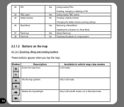
...down. Only in 2D and 3D modes, not in which map view modes In all modes. 23 POI 24 TMC event 25 Safety Camera 26 Road Block 27 Track Log 28 Point Info Yes Listing nearby POIs Creating, changing or deleting a POI Yes Listing nearby TMC events No Creating a ...Safety Camera Changing the Safety Camera warning settings Yes Removing a Road Block Updating the schedule of a Road Block Yes Using Track Log No Checking the details of a map location 2.3.1.2 Buttons on the map 4.1.2.1 Zooming, tilting and rotating buttons ...
...down. Only in 2D and 3D modes, not in which map view modes In all modes. 23 POI 24 TMC event 25 Safety Camera 26 Road Block 27 Track Log 28 Point Info Yes Listing nearby POIs Creating, changing or deleting a POI Yes Listing nearby TMC events No Creating a ...Safety Camera Changing the Safety Camera warning settings Yes Removing a Road Block Updating the schedule of a Road Block Yes Using Track Log No Checking the details of a map location 2.3.1.2 Buttons on the map 4.1.2.1 Zooming, tilting and rotating buttons ...
User Manual
Page 65
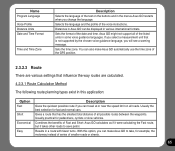
...The following route planning types exist in this option, you can be displayed in the menus.Asus GO restarts when you select a measurement unit that has the smallest total distance of all of smaller roads or streets. 65 Name Program Language Voice Profile Distance Units Date and Time Format Time ...and Time Zone Description Selects the language of the text on all roads. If you change the language. Combines the benefits of Fast and Short: Asus GO calculates as if it were calculating the Fast route, but it takes other roads to take, for example, the motorway instead of series of ...
...The following route planning types exist in this option, you can be displayed in the menus.Asus GO restarts when you select a measurement unit that has the smallest total distance of all of smaller roads or streets. 65 Name Program Language Voice Profile Distance Units Date and Time Format Time ...and Time Zone Description Selects the language of the text on all roads. If you change the language. Combines the benefits of Fast and Short: Asus GO calculates as if it were calculating the Fast route, but it takes other roads to take, for example, the motorway instead of series of ...

User Manual
Page 66
... used in the route calculation, see table below. 66 For instructions on how to your destination in any other way. Asus GO will still include such roads in the routes when it cannot plan a route to include or exclude these route types in route calculation Route calculation can be based for the... vehicle types: • Car • Taxi • Bus • Lorry • Emergency vehicles • Bicycle • Pedestrian For each vehicle type, you can set whether Asus GO should include the following route types when it is calculating a route: Note When you exclude...
... used in the route calculation, see table below. 66 For instructions on how to your destination in any other way. Asus GO will still include such roads in the routes when it cannot plan a route to include or exclude these route types in route calculation Route calculation can be based for the... vehicle types: • Car • Taxi • Bus • Lorry • Emergency vehicles • Bicycle • Pedestrian For each vehicle type, you can set whether Asus GO should include the following route types when it is calculating a route: Note When you exclude...

User Manual
Page 67
... pass or vignette to enter certain areas. You might need to your U-turn this , Asus GO avoids U-turns whenever possible. Charge roads are towing another country. Asus GO excludes unpaved roads by default. However, a map does not necessarily contain information about the accessibility of the... preferences. Note: Asus GO considers waypoints as a U-turn . If you enable this option off. 67 If you disable toll roads, Asus GO plans the best toll-free route. Asus GO includes ferries in the routes. By default Asus GO includes toll roads (pay roads where there is ...
... pass or vignette to enter certain areas. You might need to your U-turn this , Asus GO avoids U-turns whenever possible. Charge roads are towing another country. Asus GO excludes unpaved roads by default. However, a map does not necessarily contain information about the accessibility of the... preferences. Note: Asus GO considers waypoints as a U-turn . If you enable this option off. 67 If you disable toll roads, Asus GO plans the best toll-free route. Asus GO includes ferries in the routes. By default Asus GO includes toll roads (pay roads where there is ...
User Manual
Page 69
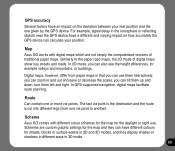
...one given by the GPS device. Schemes are not simply the computerised versions of digital maps show you can zoom in 3D mode. 69 Map Asus GO works with different colour schemes for the map for example valleys and mountains, or buildings. Route Can contain one or more via point to... the paper road maps, the 2D mode of traditional paper maps. For example, signal delay in the ionosphere or reflecting objects near the GPS device have a different ...
...one given by the GPS device. Schemes are not simply the computerised versions of digital maps show you can zoom in 3D mode. 69 Map Asus GO works with different colour schemes for the map for example valleys and mountains, or buildings. Route Can contain one or more via point to... the paper road maps, the 2D mode of traditional paper maps. For example, signal delay in the ionosphere or reflecting objects near the GPS device have a different ...