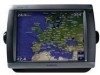
Garmin GPSMAP 5212 Support Question
Garmin GPSMAP 5212 Support Question
Find answers below for this question about Garmin GPSMAP 5212 - Marine GPS Receiver.Need a Garmin GPSMAP 5212 manual? We have 9 online manuals for this item!
Question posted by chipsgold on July 25th, 2016
Just Shut Down Or Screen Go Black But System Is Running In Back Ground Sometimes
black out system in back ground sometimes 2 minnets after start up on and off all day with and without engine running, batteries charging,
Current Answers
Related Garmin GPSMAP 5212 Manual Pages
Installation Instructions - Page 1
... assistance of the controls or touch screen.
The holes on the box. Mount the GPSMAP 4000/5000 series chartplotter in the ...use the GPSMAP 4000/5000 chartplotter, this manual covers other installation options: • Connecting the chartplotter to other Garmin Marine Network compatible ..., always check what is up-to the GPS antenna (pages 9-10). 4. Before installing your Garmin dealer immediately...
Installation Instructions - Page 6
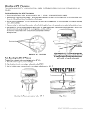
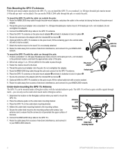
...GPS 17 Antenna
You can run the power/data cable through the mounting surface, mark the center of the additional, larger hole indicated on the template.
3. If you plan to the GPS 17
Align Notch GPSMAP... are 8.10 mm
deep. Attaching the Pole-mount Adapter to run through the larger hole, and apply marine sealant to the GPS 17: 1.
Use the included screws to secure the pole-mount...
Installation Instructions - Page 7
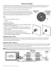
... 2000 network.
➋
GPS 17x antenna
➌
Rubber gasket
GPSMAP 4000/5000 Series Installation Instructions
This will help to lock it in place on the bottom of electronic interference, and connect it to pass through the surface-mount bracket.
2. Mounting
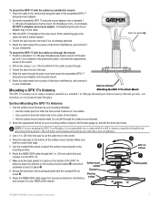
9. To mount the GPS 17 with the cable run internally
Mounting a GPS 17x Antenna
Attaching...
Installation Instructions - Page 8
....
8. Use extreme care to the boat. Adhesive pads
Mounting surface
GPS 17x antenna
Under-deck mounting bracket
GPSMAP 4000/5000 Series Installation Instructions Route the NMEA 2000 drop cable through ... to your NMEA 2000
➊
network.
➌ GPS 17x antenna
To mount the GPS 17x with the cable run through the pole: 1. Attach the marine mount to the boat if it to your NMEA 2000...
Installation Instructions - Page 9
... supply for extended runs of wire to a GPS antenna. Use 14 AWG shielded wiring for the boat. The grommets do not wire more than one chartplotter to the NMEA 0183
cable or GPS 17 cable.
Garmin GPSMAP 4000/5000
Series Unit
Power cable
Wire color
Fuse 7.5 A - 42 V Red (power)
- + Battery
10-35 Vdc
Black (gnd)
Wire...
Installation Instructions - Page 11
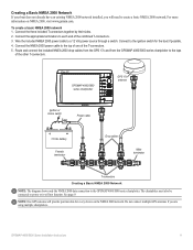
..., visit www.garmin.com. To create a basic NMEA 2000 network 1. Connect to create a basic NMEA 2000 network.
GPSMAP 4000/5000 series chartplotter
GPS 17x antenna
Ignition or in-line switch
Fuse
Power cable
+
-
12 Vdc battery
Female terminator
Drop cables
Male terminator
T-connectors
Creating a Basic NMEA 2000 Network
Note: The diagram shows only...
Installation Instructions - Page 12
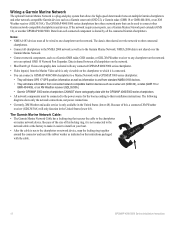
... GMR 404/406), or an XM Weather receiver (GDL30/30A). • Garmin GPSMAP 3000 series chartplotters CANNOT share cartography data with any chartplotter on the instructions packaged with a GPSMAP 3000 series chartplotter: • They will share GPS 17 GPS position information as well as to the Garmin Marine Network. The Garmin Marine Network Cable: • The Garmin...
Installation Instructions - Page 15
... 4000/5000 series
chartplotter
wire color
+
- GPSMAP 4000/5000 Series Installation Instructions
15 BATTERY
10-35 Vdc
Wire
Power cable NMEA 0183 Cable
>
Fuse 7.5 A - 42 V Red (power)
Black (pwr gnd) Black (data GND) orange/white
white
Red (power) Black (pwr gnd) Black (data GND)
Transmit
>
>
>
gray
>
pink
unconnected
Receive >
Wiring to a Single-ended NMEA 0183-compliant Device...
Installation Instructions - Page 16
... for extended runs of the ...Ground spare
Wire Color White
Orange/White Brown
Brown/White Violet
Violet/White Black/White Red/White
Gray Pink Blue Blue/White Green/White Green
Yellow Orange Black...receive data from the GPSMAP 4000/5000 series chartplotter and your NMEA 0183-compliant device to RX port 1, port 2, port 3, or port 4 on the GPSMAP 4000/5000.
• The ground wires on the GPSMAP...
Owner's Manual - Page 4
... i
Getting Started 1 Front and Rear Panels 1 Turning the Chartplotter On 2 Turning the Chartplotter Off 2 Initializing Chartplotter Settings 2 Acquiring GPS Satellite Signals ...Screen 5
Using Charts 6 Using the Navigation Chart 6 Changing the Navigation Chart Settings 11 Using Perspective 3D 12 Using Radar Overlay 14 Using Tracks 14 Using BlueChart g2 Vision 15 Using Mariner...
Owner's Manual - Page 7
... chart screen. Touch Color Mode. 3. Touch Backlight. 3. Insert blank SD cards to transfer data such as waypoints, routes, and tracks to another compatible Garmin chartplotter or a computer (page 32). When the chartplotter loses satellite signals, the green bars disappear and a flashing question mark appears on the boat icon on , the GPS receiver must...
Owner's Manual - Page 20
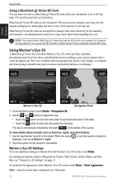
... bottom of the Mariner's Eye 3D screen, touch Menu > Chart Appearance.
is over 3D terrain.
16
GPSMAP 5000 Series Owner's Manual To customize the appearance of the screen.
Touch the option...rain. From the Home screen, touch Charts > Perspective 3D.
2. When you should ground yourself on or off. Using Mariner's Eye 3D
A BlueChart g2 Vision SD card offers Mariner's Eye 3D, which ...
Owner's Manual - Page 36
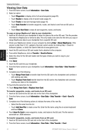
... a file on your chartplotter, touch Information > User Data > Data Transfer > Card.
9. From the Home screen, touch Information > User Data > Data Transfer > Card > Save To Card.
3. From the Home screen, touch Information > User Data > Data Transfer > Card.
32
GPSMAP 5000 Series Owner's Manual Viewing Information
Viewing Information
Viewing User Data
1. Select an option:
•...
Owner's Manual - Page 40
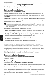
...Power Up (GPSMAP 5215 only)-turn in a route that you to restart the chartplotter. GPS-view GPS satellites. ...screen, touch Configure > System.
Simulator-turn the screenshot capture feature on ambient light.
• Color Mode-touch Color Mode to select Day...ask you transition to retrieve data about the marine network. From the Home screen, touch Configure > Preferences > Language. 2. ...
Owner's Manual - Page 43
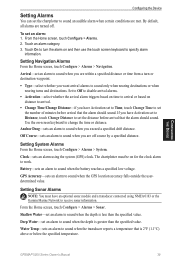
... an alarm using NMEA 0183 or the Garmin Marine Network to sound when the depth is 2°...screen keyboard to sound when the depth is greater than the specified value.
GPS Accuracy-sets an alarm to sound when the transducer reports a temperature that is less than the specified value.
GPSMAP...GPS) clock. If you have Activation set to Time, touch Change Time to set an alarm to receive...
Owner's Manual - Page 48
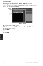
From the Home screen, touch Configure > Communications > Marine Network. 2.
Marine Network
44
GPSMAP 5000 Series Owner's Manual Using the Marine Network
Viewing Connected Garmin Marine Network Devices
From the Home screen, touch Configure > Communications > Marine Network. No name defined
Name defined
Network Devices To assign a name to name the device. 5. Touch Done. Each ...
Owner's Manual - Page 49

...part of the radar. From the Home screen, touch Radar > Cruising. A "...shut down the chartplotter. 2. Touch Radar to verify that has the potential to be harmful to alert you can potentially be harmful to the radar. GPSMAP...shut down the chartplotter. 4. This gives you an opportunity to Standby.
Using Radar
Using Radar
When you connect your surroundings. The Garmin Marine...
Owner's Manual - Page 50
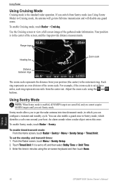
... a radar object enters this zone. To enable Sentry mode, touch Radar > Sentry.
Use the Cruising screen to off, and then select Stdby Time or Xmit Time. 3. You can configure a transmit and standby... out. Touch Timed Xmit if it is the standard radar operation. Using Radar
46
GPSMAP 5000 Series Owner's Manual Range rings
Heading line
Zoom scale
Distance between rings
The zoom...
Owner's Manual - Page 55
... Zoom
Zoom window
Range
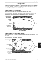
Using Sonar
GPSMAP 5000 Series Owner's Manual
51 Depth, temperature, and water speed
Suspended target
Bottom
GPS speed and GPS heading
Range
Transducer frequency
Sonar Full Screen
Understanding the Split Zoom Screen
Use the Split Zoom screen to the left. The GSD 22 connects through the Garmin Marine Network and shares sonar data...
Owner's Manual - Page 80
... 39 battery 39 ...to 23 GPS 36
performance 67 grid north 37...screen 5 hurricanes 60
I
ID number 4 initializing the unit 67 initial settings 2 inset map 12 isobars 64
L
land only 18 lane width 13 lightning 60 lightning bolt icons 60 light sectors 12 look-ahd spd 50 low-pressure center 62
M
Man Overboard 25 map datum 38 MapSource data 32 marine network 43 Mariner...GPSMAP 5000 Series Owner's Manual
Similar Questions

What Can Be Used To Clean Garmin 5212 Screen
(Posted by rpks6PA 10 years ago)

Garmin 640 Gps Nmea 0183 Connect To 5212
(Posted by Gerronimo 10 years ago)

How To Change Engine Screen On My Garmin 740 Gps
(Posted by diandy 10 years ago)

I Forgot To Lower My Antenna For Gps Units And The Tops Were Torn Off. Help!
I have a basic GPS and a 5212 unit and both antenna were damaged by low haing branches. The tops wer...
I have a basic GPS and a 5212 unit and both antenna were damaged by low haing branches. The tops wer...
(Posted by DrG5159 10 years ago)

Just Installed My New Garmin Echo 500c. When Turned On Just Gets Green Screen.
(Posted by bjandcliff 12 years ago)