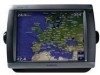
Garmin GPSMAP 5212 Support Question
Garmin GPSMAP 5212 Support Question
Find answers below for this question about Garmin GPSMAP 5212 - Marine GPS Receiver.Need a Garmin GPSMAP 5212 manual? We have 9 online manuals for this item!
Question posted by rmrWillia on April 27th, 2014
How To Use Garmin 5212
The person who posted this question about this Garmin product did not include a detailed explanation. Please use the "Request More Information" button to the right if more details would help you to answer this question.
Current Answers
Related Garmin GPSMAP 5212 Manual Pages
Important Safety and Product Information - Page 2
Battery Warnings
Your GPS unit may use a combination of governmental and private data sources, which we identify in 1 meter of Garmin is sensitive to provide customers with a ...wipe dry. For more information on the applicability to this device must accept any interference received, including interference that is important to have the battery removed and recycled. It is specified as...
Installation Instructions - Page 1
...controls or touch screen. GPSMAP® 4000/5000 Series Installation Instructions
The GPSMAP 4000/5000 series chartplotter and GPS antenna must flush mount a GPSMAP 5015/5215 chartplotter. ... the GPSMAP 4000/5000 Series Chartplotter
You can use the GPSMAP 4000/5000 chartplotter, this manual covers other installation options: • Connecting the chartplotter to other Garmin Marine Network ...
Installation Instructions - Page 9
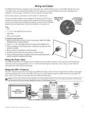
... diagram
below when wiring the GPS 17 to the diagram for a finished look. Garmin GPSMAP 4000/5000
Series Unit
Power cable...GPSMAP 4000/5000 Unit and the GPS 17
>
GPS 17 GPS/WAAS
Sensor
GPSMAP 4000/5000 Series Installation Instructions
Solder all connections and seal them with a power cable, a NMEA 2000 drop cable, a 19-pin NMEA 0183 data cable, and a 17-pin Marine Video cable. Use...
Installation Instructions - Page 12
... 18 or GMR 404/406), or an XM Weather receiver (GDL30/30A). • Garmin GPSMAP 3000 series chartplotters CANNOT share cartography data with the cable.
12
GPSMAP 4000/5000 Series Installation Instructions If the network requires more ports, use a Garmin Marine Network port extender (GMS 10), or another GPSMAP 4000/5000. NMEA 2000 data is not shared over...
Installation Instructions - Page 14
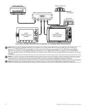
... device connected to the Garmin Marine Network must be used but do not share cartography. Note: This diagram shows the Garmin Marine Network connections; Garmin marine radar
GSD 22 sounder unit
xxxx
GMS 10 marine network port expander
xxxxxxxxxxxxxxxxxxxxxxx
To transducer
GDL 30/30A XM weather receiver
Garmin GPSMAP 3000 series
chartplotter
Garmin GPSMAP 4000/5000
series chartplotter...
Owner's Manual - Page 4
... GPS ...Using the Marine Network 43 Viewing Connected Garmin Marine Network Devices 44
Using Radar 45 Using Cruising Mode 46 Using...Using the Chartplotter with a VHF Radio 55 Adding a DSC Contact 55 Viewing the DSC List 56 Receiving...Garmin 74 Declaration of Conformity (DoC 74 Weather Data Warranty 74 Software License Agreement 75 XM Satellite Radio Service Agreement 75
Index 76
GPSMAP...
Owner's Manual - Page 20
...Use...Using Charts
Using Charts
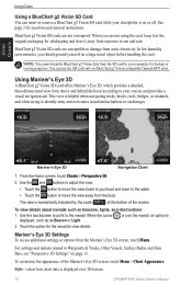
Using a BlueChart g2 Vision SD Card You can use the SD card only on page 13. See page 3 for the navaid to sun and rain.
Using Mariner's Eye 3D
A BlueChart g2 Vision SD card offers Mariner... screen.
Mariner's Eye 3D...the navaid. Mariner's Eye 3D... bottom of the Mariner's Eye 3D screen... g2 Vision-compatible Garmin GPS units. You can... you are not using the card, keep...
Owner's Manual - Page 28

... Guidance.
6.
Touch characters to the destination. Select an option: • Touch Go To. • Touch Guide To when using a preprogrammed BlueChart g2 Vision card.
24
GPSMAP 5000 Series Owner's Manual
To search for a destination by Name. 2. Where To? Touch the location.
5. From the Home screen, touch Where To? > Search by name: 1. ...
Owner's Manual - Page 40
...the Power key. a Garmin Product Support representative may ...off (page 68). GPS-view GPS satellites. The Save ...Use the Configure screen to Card option is provided as a troubleshooting tool;
When Off is selected, the chartplotter must be turned on whenever power is named Demo.)
Auto Power Up (GPSMAP...Touch Setup to retrieve data about the marine network.
Raising this setting is applied...
Owner's Manual - Page 43
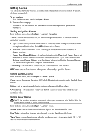
...alarm using NMEA 0183 or the Garmin Marine Network to set the number of minutes before arrival that the alarm should sound.
GPSMAP 5000 ...an optional sonar module and a transducer connected using the system (GPS) clock. Use the on distance to arrival.
• Change...temperature.
Deep Water-set to Time, touch Change Time to receive sonar information. By default, all alarms are within a ...
Owner's Manual - Page 44
...Alarm
Note: To receive fuel-level information, your transducer.
If you specify. Refer to an external fuel sensor, such as a GDL 30A) connected using the Garmin Marine Network to compensate for...If you get the message, contact Garmin Product Support.
40
GPSMAP 5000 Series Owner's Manual
Configuring the Device
-sounds an alarm for calibration. Use the on -screen directions for ...
Owner's Manual - Page 47
... series chartplotters.
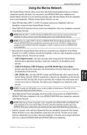
provides radar data when connected to the Garmin Marine Network and an appropriate transducer.
NOTE: If you are using a GSD 21 wired to a GPSMAP 3006/3010 chartplotter, the data is shared by all chartplotters on your GPSMAP 4000 series chartplotter to a Garmin Marine Network to receive data from an SD card inserted in North America.
•...
Owner's Manual - Page 55
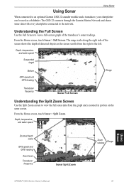
... connects through the Garmin Marine Network and shares sonar data with every chartplotter connected to view a full-screen graph of detected objects as a fishfinder. The range scale along the right side of the screen shows the depth of the transducer's sonar readings. Using Sonar
Using Sonar
When connected to an optional Garmin GSD 22 sounder...
Owner's Manual - Page 63
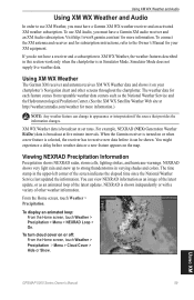
...broadcast at set rates. You might experience a delay before it on the map. Using XM
GPSMAP 5000 Series Owner's Manual
59
The time stamp in appearance or interpretation if the... other weather information.
To use XM Weather, you must have a Garmin XM WX weather receiver and an activated XM weather subscription. To connect the XM antenna and receiver and for more information.)...
Technical Reference for Garmin NMEA 2000 Products - Page 4
... Service 18 Setting the Speed Filter...18 Refreshing GPS Satellite Acquisition...18 Restoring Factory Default Settings...18 GFS 10 (Garmin Fuel Sensor)...19 Using Fuel-Flow Information With a Garmin Chartplotter or Marine Instrument...19 Changing the Fuel Economy Source...19 Using Fuel-Level Information With a Garmin Chartplotter or Marine Instrument...19 Configuring Engine and Tank Information...
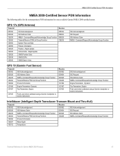
Technical Reference for Garmin NMEA 2000 Products - Page 13
... Waypoint Distance to the NMEA 2000-certified display devices (such as a GPSMAP 4000/5000 series chartplotter or a GMI 10) on the sensors you ...Garmin Chartplotter and GPS Antenna
Garmin Chartplotter and GPS Antenna
Garmin Chartplotter Garmin Chartplotter and GPS Antenna Garmin Chartplotter and GPS Antenna Garmin Chartplotter and GPS Antenna Garmin Chartplotter and GPS Antenna Heading Sensor GPS...
Technical Reference for Garmin NMEA 2000 Products - Page 14

...Water Speed Sensor are not present, a less accurate reading can be calculated using only the Wind Sensor and GPS antenna [130306 - Water Speed
Water Speed Sensor
130314 - Wind Data, 129026... Pressure, 130310 - Envir Param Old, Barometric Pressure Sensor or 130311 - Nav Data
Garmin Chartplotter and GPS Antenna
129026 - Vessel Heading, and 128259 - Water Speed
(If a Heading Sensor ...
Technical Reference for Garmin NMEA 2000 Products - Page 15

..., and Speed Sensor or a Wind Sensor, a Heading Sensor, and a GPS Antenna
Opposite Tack Heading
130306 - Wind Data, 129026 - GNSS Position])
(If a GPS antenna is not present, a less accurate reading can be calculated using only the Wind Sensor and GPS antenna [130306 - Nav Data
Garmin Chartplotter and GPS Antenna
Maximum Apparent Wind Speed 130306 - Wind Data, 127250...
Technical Reference for Garmin NMEA 2000 Products - Page 19
...15 Rapid Update COG & SOG - Dynamic
Trip Parameters, Engine Fluid Level (when calibrated using a Garmin chartplotter or marine instrument)
ISO Acknowledgement ISO Request ISO Address Claim NMEA-Command/Request/Acknowledge Group Function Engine Parameters - Command/Request/Acknowledge Group Function Transmit/Receive PGN List Group Function System Time and Date Product Information Position - Rapid...
Technical Reference for Garmin NMEA 2000 Products - Page 23
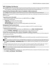
... rate, you must specify the amount of fuel added: 1. Using Fuel-Flow Information With a Garmin Chartplotter or Marine Instrument
Caution: The Garmin chartplotter or marine instrument must be powered on to the GFS 10 Installation Instructions.
Using Fuel-Level Information With a Garmin Chartplotter or Marine Instrument To receive fuel-level information, connect the wiring harness on the GFS 10...
Similar Questions

How Do I Go Into Simulation Mode On A Garmin Marine Gps Modle741xs
how do I use simulation mode on a garmin 741xs marine ver
how do I use simulation mode on a garmin 741xs marine ver
(Posted by Curthupp 6 years ago)

Which Camera Is Controlled With Gpsmap 5212
(Posted by sofory 9 years ago)

What Can Be Used To Clean Garmin 5212 Screen
(Posted by rpks6PA 10 years ago)

Garmin 640 Gps Nmea 0183 Connect To 5212
(Posted by Gerronimo 10 years ago)