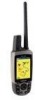
Garmin Astro 220 Support Question
Garmin Astro 220 Support Question
Find answers below for this question about Garmin Astro 220 - Hiking GPS Receiver.Need a Garmin Astro 220 manual? We have 3 online manuals for this item!
Question posted by Kbouraskonstantinos on September 17th, 2014
Off Road Colour Change
How can I change the colour of the off road races?
Current Answers
Related Garmin Astro 220 Manual Pages
Owner's Manual - Page 15
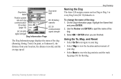
... Astro 220 assigns a name such as Dog or Dog 1 to every Dog Unit (DC 30) linked to it. Select OK > ENTER when you are finished. Astro Dog Tracking System Owner's Manual
To change the... dog
DC 30 battery
communication
capacity
ID number (page 13)
DC 30 communication
DC 30 GPS
signal strength
signal strength
Dog Information Page
The Dog Information page displays the status of the dog...
Owner's Manual - Page 28

...for this location (page 14).
• Reposition Here-changes the location of Interest category to your current region.
2.
If your unit has a GPS fix, the field is populated with your current location.... an item near another item (page 20).
• Change Reference-finds an item from another location on the keypad).
22
Astro Dog Tracking System Owner's Manual Enter the street number using...
Owner's Manual - Page 30
... page, press MENU.
24
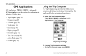
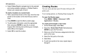
Astro Dog Tracking System Owner's Manual Trip Computer Page To change Trip Computer settings: 1. To open the Trip Computer page:
Press MENU > MENU > Advanced > GPS Applications > Trip Computer. GPS Applications
GPS Applications
GPS Applications (MENU > MENU > Advanced > GPS Applications) provides options for configuring the following GPS functions:
• Trip Computer...
Owner's Manual - Page 31

...Astro Dog Tracking System Owner's Manual 25 Press ENTER > select an option > ENTER.
Bearing pointer
The compass ring moves to ensure maximum accuracy.
Use the Rocker to your destination with larger numbers. • Change Data Fields-changes...to the default settings. GPS Applications
To open the Compass page: Press MENU > MENU > Advanced > GPS Applications > Compass.
Select...
Owner's Manual - Page 33
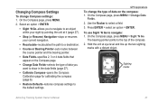
GPS Applications To change Compass settings: 1. Press ENTER > select an option > ENTER. To use Sight 'N Go to select a field....compass settings to the default settings.
Use the Rocker to navigate: 1. On the Compass page, press MENU > Change Data
Fields. 2. Sighting marks
Astro Dog Tracking System Owner's Manual 27
On the Compass page, press MENU.
2. The bearing pointer points to an...
Owner's Manual - Page 34
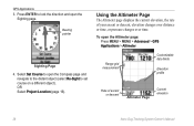
... page. GPS Applications 3. Using the Altimeter Page
The Altimeter page displays the current elevation, the rate of ascent or descent
Altimeter Page
Current elevation
28
Astro Dog Tracking... System Owner's Manual Range grid measurement
Customizable data fields
Elevation profile
Rate of your ascent or descent, elevation changes over distance or time, or pressure changes...
Owner's Manual - Page 35
... from your rate of day, and the date when the point was recorded.
Astro Dog Tracking System Owner's Manual 29 GPS Applications
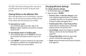
Changing Altimeter Settings
To change altimeter settings: 1. On the Altimeter page, press MENU.
2. To view points...and time for the View Elevation Plot (page 30).
• Change Data Fields-selects the type of data shown on the Rocker to view on the Map page: 1.
Owner's Manual - Page 36

GPS Applications
• Calibrate Altimeter-calibrates the altimeter if you know the barometric pressure.
4. On the ... right on the Rocker to set the zoom ranges for each point.
30
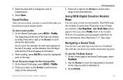
Astro Dog Tracking System Owner's Manual Using Tracks
A track is known
2. On the Altimeter page (page 28), press MENU >
Change Data Fields.
2.
To calibrate the altimeter: 1. On the Altimeter page, ...
Owner's Manual - Page 37
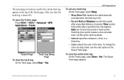
...Record Method-Distance records track points after a specified time has elapsed. The Saved Track page appears.
GPS Applications
To set up the track log faster.
• Interval-specifies a distance, a time,...Saved Track page.
Astro Dog Tracking System Owner's Manual
31 To open the Tracks page: Press MENU > MENU > Advanced > GPS Applications > Tracks. To change the color of the ...
Owner's Manual - Page 38
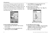
..., and the color for the calculated area.
To save a portion of a dog's saved track also changes the dog pointer color on the Map
To calculate the area of a track: 1. When you are ... Track on the Dog Tracker page.
3. Astro Dog Tracking System Owner's Manual To view a track on the map. Changing the color of the track log: 1.
GPS Applications
Use the Saved Track page to start...
Owner's Manual - Page 39
...While scrolling, press ENTER to show the highlighted point on the vertical axis. Astro Dog Tracking System Owner's Manual
GPS Applications 3. Press left or right on the Rocker to the Garmin Web site...the Rocker to use the TracBack feature: 1. Use the Rocker to move the map pointer to change the units of the path you have a record of measurement.
4.
3. Select the Area field ...
Owner's Manual - Page 40
... steps 2
through 5.
34
Astro Dog Tracking System Owner's Manual To create and navigate a new route: 1. Select the first point on -screen keypad. Select Follow Road to navigate back to the ... the appropriate field, and press ENTER to retrace your changes, select OK (on the keypad).
4. Select the field and press
ENTER to mark.
2. GPS Applications
4.
Select one of travel. To add more...
Owner's Manual - Page 41
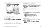
...Select Review to edit the route, change the name of the route: 1. Astro Dog Tracking System Owner's Manual
35
After entering your changes, select OK (on the Map Page...Routes page, select a saved route > Delete.
On the Routes page, select a saved route.
2. GPS Applications
To change the route name, and review route points. 7. Select Navigate.
To stop navigating, press MENU > Stop...
Owner's Manual - Page 42
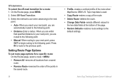
...the route. • Change Data Fields-selects different values for
the two data fields at the bottom of the route when MapSource DEM U.S. GPS Applications
To select the off-road transition for a specific route...following point.
Setting Route Page Options
To set route page options for a route: 1. Astro Dog Tracking System Owner's Manual Select the method to use when advancing to the next
...
Owner's Manual - Page 43
....
An alarm sounds when you
want to four data fields that
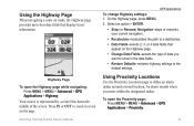
appear on roads, the Highway page provides up to show in or out on the map.... MENU > Advanced > GPS Applications > Highway. Highway Page To open the Proximity page: Press MENU > MENU > Advanced > GPS Applications > Proximity.
37 Astro Dog Tracking System Owner's Manual
GPS Applications To change Highway settings: 1. Press...
Owner's Manual - Page 45
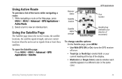
... MENU > MENU > Advanced > GPS Applications > Satellite.
Astro Dog Tracking System Owner's Manual
39 Using the Satellite Page
The Satellite page shows the receiver status, the satellite locations, the...To change satellite options: On the Satellite page, press MENU.
• Use With GPS Off (or On)-turns the GPS receiver off or on the Map page, press
MENU > MENU > Advanced > GPS Applications ...
Owner's Manual - Page 51
....
• GPS Lost Alert-indicates that the dog is not receiving the signals from the list:
Select a dog on or off: 1. Use the Rocker to Day, Night, or Auto mode.
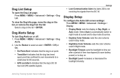
Dog List Setup
To open the Dog List page: Press MENU > MENU > Advanced > Settings > Dog List.
Display Setup
To configure the Astro 220 screen...
Owner's Manual - Page 59

...MENU > MENU > Advanced > Settings >
Altimeter.
2. Trip data is corrected by the GPS receiver.
To calibrate the Altimeter: Select Altimeter and follow the on -screen instructions. Select Auto ...the altimeter to function as a barometer, or to manually calibrate the altimeter when you turn the Astro 220 on , to self-calibrate each time you turn the unit on : 1. Press MENU > ...
Owner's Manual - Page 60
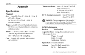
DC 30: 4.1 oz. (116 g) with batteries and antenna and without batteries.
GPS Performance
Receiver:
WAAS enabled
Acquisition Times: average, for a stationary receiver with backlighting. Warm: 15 seconds Cold: 45 seconds AutoLocate: 2 minutes
Update Rate: 1/second, continuous
Antenna: Astro 220: Built-in quad helix DC 30: Built-in . D
(57 × 159 × 32 mm) DC 30: 1.4 in...
Owner's Manual - Page 70

...computer page 25 change dog unit type 10 change comm. Index
Index
Symbols
? symbol 11
A
accessories 41, 56 accuracy, GPS 55 active route 39 adding dogs to the dog list 12 addresses 22 alarms
marine 51 proximity 37, 44 alarm tones 38 alert GPS lost 45 lost...measuring 19 distance/speed 52 dog alerts 45 dog information page 9 dog list setup 45 dog status 11
Astro Dog Tracking System Owner's Manual
Similar Questions

Garmin Astro 220 How To Change Satellite
(Posted by duncala 9 years ago)

How To Change Astro 220 Firmware
(Posted by toscanatre 10 years ago)

How To Fix A Garmin Gps Astro 220 Tracking System
(Posted by mjlegnatash 10 years ago)

How To Change The English To Persian Language Of Garmin Gps 72h ?
how to change the english to persian language of Garmin GPS 72H ?
how to change the english to persian language of Garmin GPS 72H ?
(Posted by sirussh 11 years ago)

I Want To Change My Gps To Arc1960 And Use Datum Zone 36n How Can I Do That?
(Posted by bmatemachani22 11 years ago)