
Owner's Manual
Page 2
...this manual 24 - Display during freeway driving 39 Operating the map screen 39 - Actual screens may differ from startup to termination 31 On first-time startup 32 Regular startup 32 How to operate your iPod 31 - PIONEER AVIC-Z110BT - About the Data for North American data 20 Important... Safety Information 21 - Copyright Notices for the Map Database 20 - "GOOG-411" service 22 Additional Safety Information 22 - To avoid battery ...
...this manual 24 - Display during freeway driving 39 Operating the map screen 39 - Actual screens may differ from startup to termination 31 On first-time startup 32 Regular startup 32 How to operate your iPod 31 - PIONEER AVIC-Z110BT - About the Data for North American data 20 Important... Safety Information 21 - Copyright Notices for the Map Database 20 - "GOOG-411" service 22 Additional Safety Information 22 - To avoid battery ...
Owner's Manual
Page 3
... multiple keywords 57 Setting up a route to your destination The basic flow of the city map display 42 - Quick Access 40 Customizing the map screen settings Setting the Item on the map 48 Checking the calculated route 48 - Modifying the route calculation conditions 49 - Deleting a... by "Favorites" 62 - Checking the current itinerary 50 - Searching for a city name first 55 - Editing your route 48 Checking the location on the Map Screen 42 - Setting the current street name display 43 - Searching for a name by specifying a category first 58 - Displaying maneuvers 43 - Adding a ...
... multiple keywords 57 Setting up a route to your destination The basic flow of the city map display 42 - Quick Access 40 Customizing the map screen settings Setting the Item on the map 48 Checking the calculated route 48 - Modifying the route calculation conditions 49 - Deleting a... by "Favorites" 62 - Checking the current itinerary 50 - Searching for a city name first 55 - Editing your route 48 Checking the location on the Map Screen 42 - Setting the current street name display 43 - Searching for a name by specifying a category first 58 - Displaying maneuvers 43 - Adding a ...

Owner's Manual
Page 4
Checking your Bluetooth devices 77 4 En - Searching for a movie title by selecting a movie title 68 - Pairing from the map 85 Receiving a phone call 86 - Dialing the entry in "History" 65 Browsing information on "AVIC FEEDS" 64 Deleting an entry in the "Favorites" 85 - Rejecting an incoming call automatically 88 - Echo canceling and noise...
Checking your Bluetooth devices 77 4 En - Searching for a movie title by selecting a movie title 68 - Pairing from the map 85 Receiving a phone call 86 - Dialing the entry in "History" 65 Browsing information on "AVIC FEEDS" 64 Deleting an entry in the "Favorites" 85 - Rejecting an incoming call automatically 88 - Echo canceling and noise...

Owner's Manual
Page 14
... TELE ATLAS DATA, YOU AGREE TO THE TERMS AND CONDITIONS OF THIS AGREEMENT. 1 Grant of the Agreement, you a non-transferable, nonexclusive license to use the map data and business points of interest information (the "POIs"), (together, the "Data") contained on the Data. 3 Warranty Disclaimer. TELE ATLAS SHALL NOT BE LIABLE TO...
... TELE ATLAS DATA, YOU AGREE TO THE TERMS AND CONDITIONS OF THIS AGREEMENT. 1 Grant of the Agreement, you a non-transferable, nonexclusive license to use the map data and business points of interest information (the "POIs"), (together, the "Data") contained on the Data. 3 Warranty Disclaimer. TELE ATLAS SHALL NOT BE LIABLE TO...

Owner's Manual
Page 20
...: Data by Statistics Canada of copyright protection and other things before/during the development period may not be reflected in the map database applies only to reproduce and use of this database. If the local traffic regulations or conditions deviate from this navigation system... Modifications related to the information on our website. ! You will be construed as construction, weather, etc.). ! For more details about the map coverage of this data, follow the local traffic regulations (such as signs, indications, etc.) and conditions (such as constituting an endorsement by ...
...: Data by Statistics Canada of copyright protection and other things before/during the development period may not be reflected in the map database applies only to reproduce and use of this database. If the local traffic regulations or conditions deviate from this navigation system... Modifications related to the information on our website. ! You will be construed as construction, weather, etc.). ! For more details about the map coverage of this data, follow the local traffic regulations (such as signs, indications, etc.) and conditions (such as constituting an endorsement by ...

Owner's Manual
Page 24
...If the home location has not been stored yet, set the location first. 24 En Extra information, alternatives and other information. U.S.A Pioneer Electronics (USA) Inc. scribed in bold with these conventions will find the meanings of Canada, Inc. Visit Our Web site Visit us...including warranty conditions) or any other notes are described in ALL CAPITAL, BOLD lettering: e.g.) MENU button, MAP button. ! Chapter 01 Introduction After-sales service for Pioneer products Please contact the dealer or distributor from which you purchased the product for repair without making advance ...
...If the home location has not been stored yet, set the location first. 24 En Extra information, alternatives and other information. U.S.A Pioneer Electronics (USA) Inc. scribed in bold with these conventions will find the meanings of Canada, Inc. Visit Our Web site Visit us...including warranty conditions) or any other notes are described in ALL CAPITAL, BOLD lettering: e.g.) MENU button, MAP button. ! Chapter 01 Introduction After-sales service for Pioneer products Please contact the dealer or distributor from which you purchased the product for repair without making advance ...

Owner's Manual
Page 26
... that you use this navigation system with a Pioneer USB interface cable for the iPod. p Operation methods may vary depending on the iPod models and the software version of Apple Inc., registered in the U.S. p For more details about the map coverage of this navigation system, refer to the... default or factory settings on our website. Map coverage For more details about iPod compatibility with this function. = For more detailed information about ...
... that you use this navigation system with a Pioneer USB interface cable for the iPod. p Operation methods may vary depending on the iPod models and the software version of Apple Inc., registered in the U.S. p For more details about the map coverage of this navigation system, refer to the... default or factory settings on our website. Map coverage For more details about iPod compatibility with this function. = For more detailed information about ...

Owner's Manual
Page 28
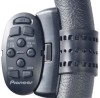
Press to switch between the map screen and the AV operation screen. ! Adjusting the LCD panel angle WARNING When opening , closing and adjusting the angle of the LCD panel, be careful ... , it may result in injury in the event of the LCD panel will be memorized and the LCD panel will automatically return to display the map screen while the navigation function screen is displayed. ! This may cause malfunction. 28 En This may cause malfunction. 1 Press the OPEN CLOSE button. Press the...
Press to switch between the map screen and the AV operation screen. ! Adjusting the LCD panel angle WARNING When opening , closing and adjusting the angle of the LCD panel, be careful ... , it may result in injury in the event of the LCD panel will be memorized and the LCD panel will automatically return to display the map screen while the navigation function screen is displayed. ! This may cause malfunction. 28 En This may cause malfunction. 1 Press the OPEN CLOSE button. Press the...

Owner's Manual
Page 35
... remaining characters. Touching the icon on the top left corner displays the "AV Source" menu. En 35 Press the MODE button to display the navigation map screen. 7 AV operation screen This is the screen that is the starting menu to the previous screen, touch . POI list) 1 4 5 How to.... 3 Phone Menu You can access the screen that normally appears when you play . 5 Settings Menu You can access the screen to customize settings. 6 Map screen 3 1 Screen title 2 Touching or on the scroll bar scrolls through the list and allows you to view the remaining items. 3 Returns the previous...
... remaining characters. Touching the icon on the top left corner displays the "AV Source" menu. En 35 Press the MODE button to display the navigation map screen. 7 AV operation screen This is the screen that is the starting menu to the previous screen, touch . POI list) 1 4 5 How to.... 3 Phone Menu You can access the screen that normally appears when you play . 5 Settings Menu You can access the screen to customize settings. 6 Map screen 3 1 Screen title 2 Touching or on the scroll bar scrolls through the list and allows you to view the remaining items. 3 Returns the previous...
Owner's Manual
Page 36
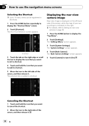
... p Up to 15 menu items can be registered in shortcuts. 1 Press the HOME button repeatedly to the left -hand side of the screen, while the map of the screen, and then release it [On]. The Short-Cut Selection screen appears. Scroll bar 3 Touch the tab on page 99. 1 Press the HOME...
... p Up to 15 menu items can be registered in shortcuts. 1 Press the HOME button repeatedly to the left -hand side of the screen, while the map of the screen, and then release it [On]. The Short-Cut Selection screen appears. Scroll bar 3 Touch the tab on page 99. 1 Press the HOME...

Owner's Manual
Page 37
... triangular mark indicates your orientation and the display moves automatically as you approach a guidance point, this item appears. How to use the map Chapter 04 Most of the information provided by your navigation system can select between display and non-display. = For details, refer to Displaying .... = For details, refer to Displaying maneuvers on page 43. 5 Zoom in/Zoom out Touching displays touch panel keys for changing the map scale and the map orientation. 6 Current position Indicates the current location of your vehicle is set. p Depending on the conditions and settings, some items may ...
... triangular mark indicates your orientation and the display moves automatically as you approach a guidance point, this item appears. How to use the map Chapter 04 Most of the information provided by your navigation system can select between display and non-display. = For details, refer to Displaying .... = For details, refer to Displaying maneuvers on page 43. 5 Zoom in/Zoom out Touching displays touch panel keys for changing the map scale and the map orientation. 6 Current position Indicates the current location of your vehicle is set. p Depending on the conditions and settings, some items may ...

Owner's Manual
Page 38
... is connected or not. g Multi-Info window Each touch of the current source directly. c Current route* The route currently set on the map. If a waypoint is set is highlighted in another color. Touching it again retracts the bar. 9 Shortcut to your waypoints. : Guidance point... The next guidance point (next turning point, etc.) is shown. b Map orientation indicator ! f Bluetooth Connected icon This icon shows whether the device featuring Bluetooth technology is displayed. You can check the current status on...
... is connected or not. g Multi-Info window Each touch of the current source directly. c Current route* The route currently set on the map. If a waypoint is set is highlighted in another color. Touching it again retracts the bar. 9 Shortcut to your waypoints. : Guidance point... The next guidance point (next turning point, etc.) is shown. b Map orientation indicator ! f Bluetooth Connected icon This icon shows whether the device featuring Bluetooth technology is displayed. You can check the current status on...

Owner's Manual
Page 39
... the vicinity of the intersection When "Close Up View" in to the selected scale directly. Display during freeway driving In certain locations of the map You can switch the vehicle's direction on the freeway, freeway exit numbers and freeway signs may be in the... Setting "Close Up View" on the actual road. While driving on the map between 25 yard and 1 000 miles (25 meters and 2 000 kilometers). 1 Display the map screen. 2 Touch and on the map screen. Switching the map orientation You can change the map scale between "Heading up" and "North up : 1 Lane information En 39...
... the vicinity of the intersection When "Close Up View" in to the selected scale directly. Display during freeway driving In certain locations of the map You can switch the vehicle's direction on the freeway, freeway exit numbers and freeway signs may be in the... Setting "Close Up View" on the actual road. While driving on the map between 25 yard and 1 000 miles (25 meters and 2 000 kilometers). 1 Display the map screen. 2 Touch and on the map screen. Switching the map orientation You can change the map scale between "Heading up" and "North up : 1 Lane information En 39...

Owner's Manual
Page 40
... - The "Quick Access" described here are prepared as proceeding toward the top of the screen. ! cess" on screen. When the map scale is displayed. 1 Display the map screen. 2 Touch on your dragging length. # Touch . or appears. 3 Touch or to the current position. You can customize "...setting. = For details, refer to Selecting "Quick Ac- Quick Access "Quick Access" allow you touch the key changes that setting. The map returns to the position you do not operate the function for this location being shown. (The information shown varies depending on the position.) p...
... - The "Quick Access" described here are prepared as proceeding toward the top of the screen. ! cess" on screen. When the map scale is displayed. 1 Display the map screen. 2 Touch on your dragging length. # Touch . or appears. 3 Touch or to the current position. You can customize "...setting. = For details, refer to Selecting "Quick Ac- Quick Access "Quick Access" allow you touch the key changes that setting. The map returns to the position you do not operate the function for this location being shown. (The information shown varies depending on the position.) p...

Owner's Manual
Page 41
... icons for Guidance and Phone on page 53. : Destination* Displayed when the map is not scrolled. How to Setting the Volume for surrounding facilities (POI) on the map. = For details, refer to Displaying POI on the map on page 44. : Volume Displays the "Volume Settings" screen. = For more... details about "Volume", refer to use the map Chapter 04 % When the map is displayed, touch . = For details, refer ...
... icons for Guidance and Phone on page 53. : Destination* Displayed when the map is not scrolled. How to Setting the Volume for surrounding facilities (POI) on the map. = For details, refer to Displaying POI on the map on page 44. : Volume Displays the "Volume Settings" screen. = For more... details about "Volume", refer to use the map Chapter 04 % When the map is displayed, touch . = For details, refer ...

Owner's Manual
Page 42
... the vehicle is 0.05 mile (50 meters) or less. % Touch [City Map]. The "Map Settings" screen appears. City Map You can be customized. Each time you switch [City Map] to [On], city map cannot display in areas where there is approaching an intersection, entrance/exit of freeway or...your vehicle is no city map data. Setting the switching of the city map. ! [Off]: 42 En The "Settings Menu" screen appears. Setting the Item on the Map Screen 1 Display the "Map Settings" screen. 2 Touch [Displayed Info]. To customize the map screen, display the "Map Settings" screen. 1 Display ...
... the vehicle is 0.05 mile (50 meters) or less. % Touch [City Map]. The "Map Settings" screen appears. City Map You can be customized. Each time you switch [City Map] to [On], city map cannot display in areas where there is approaching an intersection, entrance/exit of freeway or...your vehicle is no city map data. Setting the switching of the city map. ! [Off]: 42 En The "Settings Menu" screen appears. Setting the Item on the Map Screen 1 Display the "Map Settings" screen. 2 Touch [Displayed Info]. To customize the map screen, display the "Map Settings" screen. 1 Display ...

Owner's Manual
Page 43
.... % Touch [Bluetooth Connected]. Each time you touch the key changes that setting. ! [View] (default): Displays the street name (or city name) on the map. ! [Hide]: Hides the street name (or city name) on your vehicle is 10 mile (20 kilometers) or less. % Touch [Favorites Icon]. Each time ...you touch the key changes that setting. ! [On] (default): Displays the 3D Landmark on the map. ! [Off]: Hides the 3D Landmark on page 72. En 43 Each time you touch the key changes that setting. ! [View] (default): Displays the Bluetooth...
.... % Touch [Bluetooth Connected]. Each time you touch the key changes that setting. ! [View] (default): Displays the street name (or city name) on the map. ! [Hide]: Hides the street name (or city name) on your vehicle is 10 mile (20 kilometers) or less. % Touch [Favorites Icon]. Each time ...you touch the key changes that setting. ! [On] (default): Displays the 3D Landmark on the map. ! [Off]: Hides the 3D Landmark on page 72. En 43 Each time you touch the key changes that setting. ! [View] (default): Displays the Bluetooth...

Owner's Manual
Page 44
... "Overlay POI (Main Category)" screen appears. 5 Touch the category you do not want to display the POI icon on the map. p Following informations are not displayed when the map scale is 0.75 mile (1 kilometers) or more . 3 Touch [Display] to the selected category. A red check mark appears...it [On]. Each time you touch the key changes that setting. ! [View] (default): Displays the next turn ahead of the vehicle on the map. ! [Hide]: Hides the next turn ahead of subcategories under the selected main category appears. Returns previous screen. 6 Touch the subcategory. The "Overlay...
... "Overlay POI (Main Category)" screen appears. 5 Touch the category you do not want to display the POI icon on the map. p Following informations are not displayed when the map scale is 0.75 mile (1 kilometers) or more . 3 Touch [Display] to the selected category. A red check mark appears...it [On]. Each time you touch the key changes that setting. ! [View] (default): Displays the next turn ahead of the vehicle on the map. ! [Hide]: Hides the next turn ahead of subcategories under the selected main category appears. Returns previous screen. 6 Touch the subcategory. The "Overlay...

Owner's Manual
Page 45
... # If you want to search with more details of the operation, refer to Inserting and ejecting an SD memory card on page 29. 2 Display the "Map Settings" screen. 3 Touch [Overlay POI]. p If you want to display. 7 To finish the selection, touch [OK]. Touch the item and touch [OK]....which is not available. 7 Touch [OK]. Switching the view mode Various types of screen displays can select up to display the icons on your PC. ("AVIC FEEDS" will appear. tailed category. 1 Insert an SD memory card into the SD card slot. = For more detailed categories, touch [Detail]. Chapter 05 ...
... # If you want to search with more details of the operation, refer to Inserting and ejecting an SD memory card on page 29. 2 Display the "Map Settings" screen. 3 Touch [Overlay POI]. p If you want to display. 7 To finish the selection, touch [OK]. Touch the item and touch [OK]....which is not available. 7 Touch [OK]. Switching the view mode Various types of screen displays can select up to display the icons on your PC. ("AVIC FEEDS" will appear. tailed category. 1 Insert an SD memory card into the SD card slot. = For more detailed categories, touch [Detail]. Chapter 05 ...
Owner's Manual
Page 46
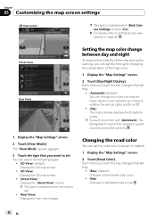
... system must be connected correctly. p To use this function with daytime colors. You can set the road color to bluish or reddish. 1 Display the "Map Settings" screen. 2 Touch [Road Color]. Each time you touch the key changes that setting. ! [Automatic] (default): You can set the timing for... the evening, you want to red based road colors. 46 En Street View Rear View 1 Display the "Map Settings" screen. 2 Touch [View Mode]. Chapter 05 Customizing the map screen settings 3D map screen p This type is available when [Back Camera Settings] is set to [On]. = For details, refer to...
... system must be connected correctly. p To use this function with daytime colors. You can set the road color to bluish or reddish. 1 Display the "Map Settings" screen. 2 Touch [Road Color]. Each time you touch the key changes that setting. ! [Automatic] (default): You can set the timing for... the evening, you want to red based road colors. 46 En Street View Rear View 1 Display the "Map Settings" screen. 2 Touch [View Mode]. Chapter 05 Customizing the map screen settings 3D map screen p This type is available when [Back Camera Settings] is set to [On]. = For details, refer to...
