
Owner's Manual
Page 46
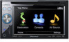
.... This function is required for the online subscription. To receive MSN Direct content, you must be updated periodically. - Coverage may not be affected by the availability and relative strength of the MSN Direct ... 3 Write your product key. Please visit http://www.msndirect.com/pioneer or current coverage area maps, subscription details, and other important information about MSN Direct™ Pioneer is used in the following box; 46 En General flow chart: ...- p A web-connected computer is available for AVIC-F900BT and AVIC-F90BT. tion, please call toll-free 1-866-658-7032.
.... This function is required for the online subscription. To receive MSN Direct content, you must be updated periodically. - Coverage may not be affected by the availability and relative strength of the MSN Direct ... 3 Write your product key. Please visit http://www.msndirect.com/pioneer or current coverage area maps, subscription details, and other important information about MSN Direct™ Pioneer is used in the following box; 46 En General flow chart: ...- p A web-connected computer is available for AVIC-F900BT and AVIC-F90BT. tion, please call toll-free 1-866-658-7032.
Owner's Manual
Page 50
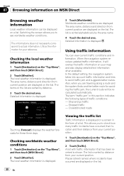
... and suggests better routes. The area name, distance and direction from your reference. The list is shown. When the navigation system receives updated traffic information, it will be displayed on the "Top Menu", and then touch [MSN Direct]. 2 Touch [Weather]. Checking worldwide weather...traffic jam, the current route will overlay the traffic information on the list. The area name, distance and direction from your map and also display detailed text information when available. Detailed information is displayed. 3 Touch [Worldwide]. Stopped traffic - Switching the screen...
... and suggests better routes. The area name, distance and direction from your reference. The list is shown. When the navigation system receives updated traffic information, it will be displayed on the "Top Menu", and then touch [MSN Direct]. 2 Touch [Weather]. Checking worldwide weather...traffic jam, the current route will overlay the traffic information on the list. The area name, distance and direction from your map and also display detailed text information when available. Detailed information is displayed. 3 Touch [Worldwide]. Stopped traffic - Switching the screen...
Owner's Manual
Page 134
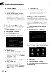
... [Manage Track Logs]. 3 Touch [Track Log Options]. 4 Touch the desired key to the external storage device (USB or SD) at once. ! "Update interval:" Sets how often the system updates the log. ! This setting will be modified later. 1 Touch [Set Home] on the "Navi Settings" menu. 2 Touch the key next to "...Limit Track DB Size" is "On", the system outputs the log files with a single touch of the search methods and locate the cursor on the map:": Touching this key displays the screen for changing the color used for logging. ! "Current autosave track size:" Sets a size limit on the color ...
... [Manage Track Logs]. 3 Touch [Track Log Options]. 4 Touch the desired key to the external storage device (USB or SD) at once. ! "Update interval:" Sets how often the system updates the log. ! This setting will be modified later. 1 Touch [Set Home] on the "Navi Settings" menu. 2 Touch the key next to "...Limit Track DB Size" is "On", the system outputs the log files with a single touch of the search methods and locate the cursor on the map:": Touching this key displays the screen for changing the color used for logging. ! "Current autosave track size:" Sets a size limit on the color ...
Owner's Manual
Page 166
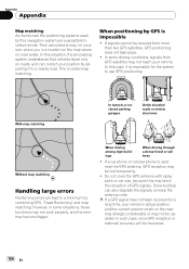
This is restored, accuracy will be updated. When positioning by this situation, the processing system understands that vehicles travel only on roads, and can also degrade the signals, so keep the antenna ... through a dense forest or tall trees ! p If a GPS signal have not been received for the system to a minimum by adjusting it is impossible ! Appendix Appendix Map matching As mentioned, the positioning systems used near the GPS antenna, GPS reception may block the reception of GPS signals. Their calculations may not be...
This is restored, accuracy will be updated. When positioning by this situation, the processing system understands that vehicles travel only on roads, and can also degrade the signals, so keep the antenna ... through a dense forest or tall trees ! p If a GPS signal have not been received for the system to a minimum by adjusting it is impossible ! Appendix Appendix Map matching As mentioned, the positioning systems used near the GPS antenna, GPS reception may block the reception of GPS signals. Their calculations may not be...


