
Triton User Manual Addendum - English, French, Spanish
Page 1
..., the track was started at point A and continued around to or higher then the ones listed. The Area and Perimeter are done. Triton User Manual Addendum This addendum applies to Triton GPS receivers that have a software version that you can now access the Main Menu on any navigational screen press ENTER. The most noticeable change in the software is that is displayed with options to define...
..., the track was started at point A and continued around to or higher then the ones listed. The Area and Perimeter are done. Triton User Manual Addendum This addendum applies to Triton GPS receivers that have a software version that you can now access the Main Menu on any navigational screen press ENTER. The most noticeable change in the software is that is displayed with options to define...

Triton User Manual Addendum - English, French, Spanish
Page 2
... set through the navigation screens to the first leg destination (B). With the point defined, select "Enable Custom Position". Select "Go to Next" or "Go to Previous" to view map areas other then your active route. Provide the settings for the User Grid parameters. When done, the Navigation screen will be displayed with User Grid set as the map datum. Set Custom Position. Press ENTER. To turn the feature off and resume computing GPS position information, go to a previous destination...
... set through the navigation screens to the first leg destination (B). With the point defined, select "Enable Custom Position". Select "Go to Next" or "Go to Previous" to view map areas other then your active route. Provide the settings for the User Grid parameters. When done, the Navigation screen will be displayed with User Grid set as the map datum. Set Custom Position. Press ENTER. To turn the feature off and resume computing GPS position information, go to a previous destination...
Manual - English
Page 2
... SAFETY, DO NOT USE THIS NAVIGATION DEVICE WHILE DRIVING A VEHICLE. Come to yourself or others could be reproduced or transmitted in accordance with the Department of the GPS network. USE CARE The Global Positioning System (GPS) is operated by poor satellite geometry and obstructions, like buildings and large trees. USE PROPER ACCESSORIES Use only Magellan cables and antennas; Taking your selected destination. USE GOOD JUDGEMENT This product...
... SAFETY, DO NOT USE THIS NAVIGATION DEVICE WHILE DRIVING A VEHICLE. Come to yourself or others could be reproduced or transmitted in accordance with the Department of the GPS network. USE CARE The Global Positioning System (GPS) is operated by poor satellite geometry and obstructions, like buildings and large trees. USE PROPER ACCESSORIES Use only Magellan cables and antennas; Taking your selected destination. USE GOOD JUDGEMENT This product...
Manual - English
Page 3
... transmitter. This device complies with any interference received, including interference that to radio and TV reception. This equipment generates, uses and can be used in conjunction with Part 15 of the following two conditions: (1) This device may not cause harmful interference, and (2) this device must follow the specific operating instructions for an uncontrolled environment. FCC Caution: Any changes or modifications not...
... transmitter. This device complies with any interference received, including interference that to radio and TV reception. This equipment generates, uses and can be used in conjunction with Part 15 of the following two conditions: (1) This device may not cause harmful interference, and (2) this device must follow the specific operating instructions for an uncontrolled environment. FCC Caution: Any changes or modifications not...
Manual - English
Page 4
... exposure limits set forth for product updates and additional information. IMPORTANT SAFETY WARNINGS IC statement Operation is 66°C. © 2009 MiTAC International Corporation. This device must accept any formal notification. End users must not be co-located or operating in this document is subject to the product may occur without notice. This transmitter must follow the specific operating instructions for...
... exposure limits set forth for product updates and additional information. IMPORTANT SAFETY WARNINGS IC statement Operation is 66°C. © 2009 MiTAC International Corporation. This device must accept any formal notification. End users must not be co-located or operating in this document is subject to the product may occur without notice. This transmitter must follow the specific operating instructions for...
Manual - English
Page 5
... ...1 Features of the Magellan Triton 1 Specifications ...3 Fundamentals ...4 Turning the Triton on 4 Turning the Triton off 4 Setting the display backlight intensity 4 Setting the Time Zone 4 Changing Languages 5 Sleep Mode (Backlight Timer 5 Waking up the Triton from Sleep Mode 5 Setting the Backlight Timer 5 Automatic Power Off 6 Setting the Power Off Timer interval 6 Menus ...6 Accessing the Main Menu 6 Navigation Screens 7 Accessing the Map Screen Contextual Menu 7 Accessing the Speedometer Contextual Menu 7 Data Fields ...8 Customizing the Data Field for the Map Screen...
... ...1 Features of the Magellan Triton 1 Specifications ...3 Fundamentals ...4 Turning the Triton on 4 Turning the Triton off 4 Setting the display backlight intensity 4 Setting the Time Zone 4 Changing Languages 5 Sleep Mode (Backlight Timer 5 Waking up the Triton from Sleep Mode 5 Setting the Backlight Timer 5 Automatic Power Off 6 Setting the Power Off Timer interval 6 Menus ...6 Accessing the Main Menu 6 Navigation Screens 7 Accessing the Map Screen Contextual Menu 7 Accessing the Speedometer Contextual Menu 7 Data Fields ...8 Customizing the Data Field for the Map Screen...
Manual - English
Page 6
... Strip and Road Compass Screens 15 The Altimeter / Barometer Screen (Magellan Triton 500 16 The Satellite Status Screen 16 Explanation of Data Field Types 17 Map Screen ...19 Map Screen Overview 19 Customizing the Map Screen Data Fields 20 Saving Your Current Position as a Waypoint 20 Saving a Position as a Waypoint using Pan 20 Displaying Best Fishing and Hunting Times 21 Displaying Solar and Lunar Rise and Set Times 21 Creating a Go To Route from the Map Screen 22 Viewing Waypoint...
... Strip and Road Compass Screens 15 The Altimeter / Barometer Screen (Magellan Triton 500 16 The Satellite Status Screen 16 Explanation of Data Field Types 17 Map Screen ...19 Map Screen Overview 19 Customizing the Map Screen Data Fields 20 Saving Your Current Position as a Waypoint 20 Saving a Position as a Waypoint using Pan 20 Displaying Best Fishing and Hunting Times 21 Displaying Solar and Lunar Rise and Set Times 21 Creating a Go To Route from the Map Screen 22 Viewing Waypoint...
Manual - English
Page 7
... the Map Screen 34 Creating a Custom Waypoint Using the Triton Menu 35 Viewing Waypoints 35 Viewing a Saved Waypoint 35 Editing Waypoints 36 Editing a Saved Waypoint 36 Deleting a Saved Waypoint 36 Deleting a Saved Waypoint (Alternate Method 36 Deleting All Saved Waypoints 37 Duplicating a Saved Waypoint 37 Settings ...38 Customizing Navigation Settings 38 Setting Volume and Brightness 38 View Memory Usage 38 Clearing Memory 39 Restoring Factory Settings 39 Setting Connectivity 39 Getting Software Version Information 40 Viewing Copyright Information 40 Personalizing Magellan...
... the Map Screen 34 Creating a Custom Waypoint Using the Triton Menu 35 Viewing Waypoints 35 Viewing a Saved Waypoint 35 Editing Waypoints 36 Editing a Saved Waypoint 36 Deleting a Saved Waypoint 36 Deleting a Saved Waypoint (Alternate Method 36 Deleting All Saved Waypoints 37 Duplicating a Saved Waypoint 37 Settings ...38 Customizing Navigation Settings 38 Setting Volume and Brightness 38 View Memory Usage 38 Clearing Memory 39 Restoring Factory Settings 39 Setting Connectivity 39 Getting Software Version Information 40 Viewing Copyright Information 40 Personalizing Magellan...

Manual - English
Page 9
....com/support/ and select your Magellan Triton model for first time GPS receiver users while still keeping all the features needed to be installed in map - Access optional detail maps for marine cartography, topographic maps, as well as feature-packed National Geographic maps from an SD card that you for the Magellan Triton 300, loaded onto the internal memory. SD-card expansion - (Triton 400 & 500 only) Use an optional SD memory card to add detailed maps...
....com/support/ and select your Magellan Triton model for first time GPS receiver users while still keeping all the features needed to be installed in map - Access optional detail maps for marine cartography, topographic maps, as well as feature-packed National Geographic maps from an SD card that you for the Magellan Triton 300, loaded onto the internal memory. SD-card expansion - (Triton 400 & 500 only) Use an optional SD memory card to add detailed maps...

Manual - English
Page 11
...) - POWER Source Battery Life Two AA Batteries (not included) Up to 5 meters (10 - 16 feet) - Specifications PHYSICAL Case Base Map Size Weight Display Data Storage Antenna Keypad Operating Range Rubber armored impact-resistant plastic, water-resistant seal, IPX-7 Built-in multidirectional patch Nine direct-access keys 14° to 140°F (-10° to 60°C) PERFORMANCE Receiver Acquisition Time Update Rate Accuracy Languages Coordinate Systems...
...) - POWER Source Battery Life Two AA Batteries (not included) Up to 5 meters (10 - 16 feet) - Specifications PHYSICAL Case Base Map Size Weight Display Data Storage Antenna Keypad Operating Range Rubber armored impact-resistant plastic, water-resistant seal, IPX-7 Built-in multidirectional patch Nine direct-access keys 14° to 140°F (-10° to 60°C) PERFORMANCE Receiver Acquisition Time Update Rate Accuracy Languages Coordinate Systems...
Manual - English
Page 12
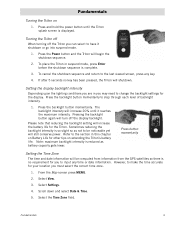
... the backlight button again will increase the battery life for your location you can select to input any key. 4. Press and hold the power button until it shutdown or go into suspend mode. 1. Please note that reducing the backlight setting will turn off the Triton you must select the correct time zone. 1. Press button momentarily Setting the Time Zone The time and date information will be noticeable...
... the backlight button again will increase the battery life for your location you can select to input any key. 4. Press and hold the power button until it shutdown or go into suspend mode. 1. Please note that reducing the backlight setting will turn off the Triton you must select the correct time zone. 1. Press button momentarily Setting the Time Zone The time and date information will be noticeable...

Manual - English
Page 14
... Trips option will turn off automatically. 7. Menus Accessing the features of the internal base map or a destination waypoint found on updates to not turn off the Triton. Select Settings. 4. Selecting one of these are used to create waypoints and multileg routes that you want the Triton to your present location, by entering the coordinates for the corresponding function. Check the Magellan website at www.magellangps.com for information...
... Trips option will turn off automatically. 7. Menus Accessing the features of the internal base map or a destination waypoint found on updates to not turn off the Triton. Select Settings. 4. Selecting one of these are used to create waypoints and multileg routes that you want the Triton to your present location, by entering the coordinates for the corresponding function. Check the Magellan website at www.magellangps.com for information...

Manual - English
Page 15
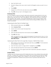
... used to create a route with them providing access to access navigation settings, adjust volume and brightness, select connectivity, view memory details, as well as solar and lunar rise and set times for a particular activity; Use Settings to additional functions. Accessing the Map Screen Contextual Menu 1. The Media option contains the functions for information on the map or by pressing the PAGE / GO TO or ESC button. (There are creating audio clips and playing MP3 music files. (Magellan...
... used to create a route with them providing access to access navigation settings, adjust volume and brightness, select connectivity, view memory details, as well as solar and lunar rise and set times for a particular activity; Use Settings to additional functions. Accessing the Map Screen Contextual Menu 1. The Media option contains the functions for information on the map or by pressing the PAGE / GO TO or ESC button. (There are creating audio clips and playing MP3 music files. (Magellan...
Manual - English
Page 20
... the route, current time, date, destination, XTE, elevation, current speed, average speed, maximum speed, distance made good (DMG), estimated time of data fields under MAP DATA FIELDS.) Customizing the Data Field for the Map Screen 1. The Triton will be needed during normal use the cursor control to select the Navigation screen you want to turn on the map screen to a waypoint, local information, backtrack and more). Navigation Screens 12 You can set the number of the operations that would be displayed...
... the route, current time, date, destination, XTE, elevation, current speed, average speed, maximum speed, distance made good (DMG), estimated time of data fields under MAP DATA FIELDS.) Customizing the Data Field for the Map Screen 1. The Triton will be needed during normal use the cursor control to select the Navigation screen you want to turn on the map screen to a waypoint, local information, backtrack and more). Navigation Screens 12 You can set the number of the operations that would be displayed...
Manual - English
Page 21
... contextual menu and selecting Reset... . The header bar shows battery level, time of your next waypoint destination if there is also displayed that rotates to the next destination waypoint. From the Map screen, press ENTER. Navigation Screens 13 Note that the contextual menu for resetting the odometer. (Additionally, the odometer can be reset from the Map screen by the detailed map, the map information from the detailed map will be displayed.) Waypoints (user-created or...
... contextual menu and selecting Reset... . The header bar shows battery level, time of your next waypoint destination if there is also displayed that rotates to the next destination waypoint. From the Map screen, press ENTER. Navigation Screens 13 Note that the contextual menu for resetting the odometer. (Additionally, the odometer can be reset from the Map screen by the detailed map, the map information from the detailed map will be displayed.) Waypoints (user-created or...

Manual - English
Page 27
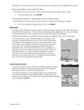
... a different icon from current location.) Track (Displays previous travel .) Pan Cursor (Cursor indicating point on the map while panning around the screen. Red dot points towards your receiver. Map Screen Overview Battery Level Time of Day GPS Signal Strength North Indicator Data Fields Map Scale Pan Mode Map Legend Present Position Cursor (Points in the Magellan Triton and it has a special contextual menu that can be performed directly from this screen an important part of...
... a different icon from current location.) Track (Displays previous travel .) Pan Cursor (Cursor indicating point on the map while panning around the screen. Red dot points towards your receiver. Map Screen Overview Battery Level Time of Day GPS Signal Strength North Indicator Data Fields Map Scale Pan Mode Map Legend Present Position Cursor (Points in the Magellan Triton and it has a special contextual menu that can be performed directly from this screen an important part of...
Manual - English
Page 40
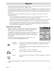
... on geocache waypoints can use them when creating a route. Waypoint Detail Screen Overview Whenever a waypoint is being created, the Waypoint Detail screen is a point on the map or by pressing the PAGE / GO TO button. The Magellan Triton automatically assigns a name for the waypoint using the convention of your current location, picking a point on the map. Used to attach a media file to your destination. Select Add Media to assign an...
... on geocache waypoints can use them when creating a route. Waypoint Detail Screen Overview Whenever a waypoint is being created, the Waypoint Detail screen is a point on the map or by pressing the PAGE / GO TO button. The Magellan Triton automatically assigns a name for the waypoint using the convention of your current location, picking a point on the map. Used to attach a media file to your destination. Select Add Media to assign an...
Manual - English
Page 47
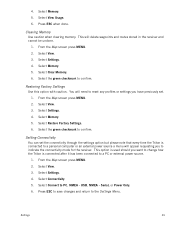
... receiver. Select Connectivity. 5. Serial, or Power Only. 6. Clearing Memory Use caution when clearing memory. You will need to reset any profiles or settings you have previously set the connectivity through the settings option but please note that every time the Triton is connected to a personal computer or an external power source a menu will delete waypoints and routes stored in the receiver and cannot be undone. 1. Select Restore Factory Settings. 6. Select Connect to confirm. From the Map screen press MENU. 2. From the Map screen press MENU. 2. 4. Select View...
... receiver. Select Connectivity. 5. Serial, or Power Only. 6. Clearing Memory Use caution when clearing memory. You will need to reset any profiles or settings you have previously set the connectivity through the settings option but please note that every time the Triton is connected to a personal computer or an external power source a menu will delete waypoints and routes stored in the receiver and cannot be undone. 1. Select Restore Factory Settings. 6. Select Connect to confirm. From the Map screen press MENU. 2. From the Map screen press MENU. 2. 4. Select View...

Manual - English
Page 50
... additional information on Map or Coordinates. (If you are entering waypoint information manually, you would probably select current location. Select from Current Location, Point on geocaching and geocaching events, go to save Geocaching 42 Geocache information includes Difficulty (1 through 5 with 5 being the most difficult), and the name of Geocaching.com can transfer.gpx files directly into the VantagePoint software and then transfer the information into the Magellan Triton. Press PAGE / GO TO to add...
... additional information on Map or Coordinates. (If you are entering waypoint information manually, you would probably select current location. Select from Current Location, Point on geocaching and geocaching events, go to save Geocaching 42 Geocache information includes Difficulty (1 through 5 with 5 being the most difficult), and the name of Geocaching.com can transfer.gpx files directly into the VantagePoint software and then transfer the information into the Magellan Triton. Press PAGE / GO TO to add...
Manual - English
Page 53
... from your current location and goes to a single destination you want to the scenic spot. If needed, change the order that the waypoints are displayed or search for the destination. 1. Tip: If you want to cross. From the Map screen, use the Create Route function and create a route with updated information as the destination. From the Map screen press MENU. (Alternate Method: Press and hold the GO TO button while the...
... from your current location and goes to a single destination you want to the scenic spot. If needed, change the order that the waypoints are displayed or search for the destination. 1. Tip: If you want to cross. From the Map screen, use the Create Route function and create a route with updated information as the destination. From the Map screen press MENU. (Alternate Method: Press and hold the GO TO button while the...


