
Getting Started Guide
Page 2
... by anyone other proprietary right, including trade secrets; Inaccurate transmissions can be the correction or replacement of the media or the software so that it is incomplete or illegible or if the serial number is connected. • Consult the dealer or an experienced... return shipment, or for repair. When removed from inaccurate satellite transmissions. Limited Warranty (North, Central and South America) Magellan Navigation warrants their GPS receivers and hardware accessories to be uninterrupted, error-free or virus-free. The repaired or replaced product will be free of ...
... by anyone other proprietary right, including trade secrets; Inaccurate transmissions can be the correction or replacement of the media or the software so that it is incomplete or illegible or if the serial number is connected. • Consult the dealer or an experienced... return shipment, or for repair. When removed from inaccurate satellite transmissions. Limited Warranty (North, Central and South America) Magellan Navigation warrants their GPS receivers and hardware accessories to be uninterrupted, error-free or virus-free. The repaired or replaced product will be free of ...

Getting Started Guide
Page 3
... the dealer from inaccurate satellite transmissions. READ THE USER GUIDE CAREFULLY BEFORE USING THE PRODUCT. 1. Magellan Navigation does not warrant the software will meet purchaser's requirements or that software products or software included in the GPS. (Note: Magellan Navigation GPS receivers use GPS or GPS+GLONASS to obtain position, velocity and English PURCHASER'S REMEDY PURCHASER'S EXCLUSIVE REMEDY UNDER THIS WRITTEN...
... the dealer from inaccurate satellite transmissions. READ THE USER GUIDE CAREFULLY BEFORE USING THE PRODUCT. 1. Magellan Navigation does not warrant the software will meet purchaser's requirements or that software products or software included in the GPS. (Note: Magellan Navigation GPS receivers use GPS or GPS+GLONASS to obtain position, velocity and English PURCHASER'S REMEDY PURCHASER'S EXCLUSIVE REMEDY UNDER THIS WRITTEN...

Getting Started Guide
Page 5
... Table of Contents Introduction 1 Key Features 1 Software Provided as Standard 2 About Windows CE .NET 2 Receiver Description 3 Front Panel 3 Back Panel 3 Side Panel 4 I/O Module 4 Resetting MobileMapper CE 4 Preparing for First-Time Use 5 Charging the battery 5 Turning the Receiver On 6 Calibrating the Screen 7 Automatic System ... GPS Status Menu Bar 16 Connecting the Internal GPS Receiver to your Application ..... 17 Step-by-Step Procedure for Establishing a GPRS Connection Via Bluetooth 18 Introduction 18 The First Time You Use MobileMapper CE 20 Step1: Ask MobileMapper CE ...
... Table of Contents Introduction 1 Key Features 1 Software Provided as Standard 2 About Windows CE .NET 2 Receiver Description 3 Front Panel 3 Back Panel 3 Side Panel 4 I/O Module 4 Resetting MobileMapper CE 4 Preparing for First-Time Use 5 Charging the battery 5 Turning the Receiver On 6 Calibrating the Screen 7 Automatic System ... GPS Status Menu Bar 16 Connecting the Internal GPS Receiver to your Application ..... 17 Step-by-Step Procedure for Establishing a GPRS Connection Via Bluetooth 18 Introduction 18 The First Time You Use MobileMapper CE 20 Step1: Ask MobileMapper CE ...

Getting Started Guide
Page 7
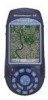
...Off-the-shelf industry standard Mobile GIS software appli- Being an open-platform Windows CE device, MobileMapper CE allows you to choose the GIS software that is a handheld device that integrates submeter GPS with Microsoft Windows CE .NET in your Windows CE GPS handheld computer. Built-in speaker and microphone...-time corrections - This Getting Started guide will also guide you in a rugged design suitable for purchasing a MobileMapper CE from Magellan. Integrated GPS with 320 x 240 resolution and touch screen - Full color, daylight readable, transflective TFT display with real-...
...Off-the-shelf industry standard Mobile GIS software appli- Being an open-platform Windows CE device, MobileMapper CE allows you to choose the GIS software that is a handheld device that integrates submeter GPS with Microsoft Windows CE .NET in your Windows CE GPS handheld computer. Built-in speaker and microphone...-time corrections - This Getting Started guide will also guide you in a rugged design suitable for purchasing a MobileMapper CE from Magellan. Integrated GPS with 320 x 240 resolution and touch screen - Full color, daylight readable, transflective TFT display with real-...

Getting Started Guide
Page 8
.... full-featured Bluetooth connectivity configuration utility - Microsoft File Viewers: Excel, Word and Image Viewers - sound record and playback program - Please contact Magellan to desktop Windows operating systems. MobileMapper CE is very similar to discuss your software development project. GPS utilities - Microsoft WordPad, Internet Explorer®, Windows Explorer, Terminal, ActiveSync®, Windows Media Player and Inbox...
.... full-featured Bluetooth connectivity configuration utility - Microsoft File Viewers: Excel, Word and Image Viewers - sound record and playback program - Please contact Magellan to desktop Windows operating systems. MobileMapper CE is very similar to discuss your software development project. GPS utilities - Microsoft WordPad, Internet Explorer®, Windows Explorer, Terminal, ActiveSync®, Windows Media Player and Inbox...
Getting Started Guide
Page 15
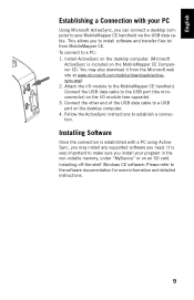
... refer to make sure you install your program in the non-volatile memory, under "MyDevice" or on the MobileMapper CE Companion CD. It is very important to the software documentation for more information and detailed instructions. 9 To connect to / from the Microsoft web site at www.... the connection is included on an SD card. This allows you to install software and transfer files to a PC: 1. You may install any supported software you need. Follow the ActiveSync instructions to your MobileMapper CE handheld via the USB data cable. English Establishing a Connection with a PC ...
... refer to make sure you install your program in the non-volatile memory, under "MyDevice" or on the MobileMapper CE Companion CD. It is very important to the software documentation for more information and detailed instructions. 9 To connect to / from the Microsoft web site at www.... the connection is included on an SD card. This allows you to install software and transfer files to a PC: 1. You may install any supported software you need. Follow the ActiveSync instructions to your MobileMapper CE handheld via the USB data cable. English Establishing a Connection with a PC ...
Getting Started Guide
Page 22
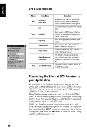
... all results). Displays the current software version of NMEA data. To do this command to be created and opened before starting logging data. Stops data logging and closes the open log file. When checked, this port from the internal GPS receiver. This virtual port may serve ...>Setup Avg Thresholds About GPS Status... Starts logging of the GPS Status utility. Resets the data shown in MobileMapper CE is a virtual COM port named "GPS VSP Output" and has fixed settings: 57600 bauds, 8 data bits, 1 stop bit and no parity. Connecting the Internal GPS Receiver to your GIS application...
... all results). Displays the current software version of NMEA data. To do this command to be created and opened before starting logging data. Stops data logging and closes the open log file. When checked, this port from the internal GPS receiver. This virtual port may serve ...>Setup Avg Thresholds About GPS Status... Starts logging of the GPS Status utility. Resets the data shown in MobileMapper CE is a virtual COM port named "GPS VSP Output" and has fixed settings: 57600 bauds, 8 data bits, 1 stop bit and no parity. Connecting the Internal GPS Receiver to your GIS application...

Getting Started Guide
Page 53
Tapping on which Mission Planning will determine the GPS constellation. - Grid: Grid lines intersecting at the center of visible satellites versus time. Tap this icon to read the software version of your site or directly tap on the map to indicate where this icon to choose the location on Earth ...for this icon to determine the GPS constellation for the GPS position (2D or 3D). PDOP: PDOP value versus time...
Tapping on which Mission Planning will determine the GPS constellation. - Grid: Grid lines intersecting at the center of visible satellites versus time. Tap this icon to read the software version of your site or directly tap on the map to indicate where this icon to choose the location on Earth ...for this icon to determine the GPS constellation for the GPS position (2D or 3D). PDOP: PDOP value versus time...

Getting Started Guide
Page 71
English The table below gives indications on how safe DGPS operation with MobileMapper Beacon will be, depending on the value of the SNR. SNR DGPS Data Reception Quality SNR
English The table below gives indications on how safe DGPS operation with MobileMapper Beacon will be, depending on the value of the SNR. SNR DGPS Data Reception Quality SNR
