User Manual
Page 4
... will be warranted for 90 days from the date of is advised to perform Return Materials Authorization (RMA) number careful position charting and use good from Thales Navigation prior to normal wear and tear; original purchase. mail to PRODUCT. Insurance is longer. ...to the parts or labor. THALES NAVIGATION WARRANTY purchaser must obtain a navigation. THALES NAVIGATION MAGELLAN PRODUCTS LIMITED WARRANTY All Thales Navigation global positioning system 3.PURCHASER'SDUTIES (GPS) receivers are navigation aids, and are excluded from the warranty OPTION, OF ANY DEFECTIVE PART OF ...
... will be warranted for 90 days from the date of is advised to perform Return Materials Authorization (RMA) number careful position charting and use good from Thales Navigation prior to normal wear and tear; original purchase. mail to PRODUCT. Insurance is longer. ...to the parts or labor. THALES NAVIGATION WARRANTY purchaser must obtain a navigation. THALES NAVIGATION MAGELLAN PRODUCTS LIMITED WARRANTY All Thales Navigation global positioning system 3.PURCHASER'SDUTIES (GPS) receivers are navigation aids, and are excluded from the warranty OPTION, OF ANY DEFECTIVE PART OF ...
User Manual
Page 48
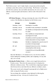
... the remaining satellites and computing a fix may take only a few seconds. Meridian is being tracked and position is computing fixes while moving. Computed fixes are being differentially corrected. GPS Status Messages - This allows the same position to toggle between devices and charts that you to be changed by following the instructions in different... by pressing the Left or Right arrows while viewing the Position screen. Three satellites are displayed on one screen. Allows you have selected in feet. Magellan Meridian GPS Receiver 37
... the remaining satellites and computing a fix may take only a few seconds. Meridian is being tracked and position is computing fixes while moving. Computed fixes are being differentially corrected. GPS Status Messages - This allows the same position to toggle between devices and charts that you to be changed by following the instructions in different... by pressing the Left or Right arrows while viewing the Position screen. Three satellites are displayed on one screen. Allows you have selected in feet. Magellan Meridian GPS Receiver 37
User Manual
Page 53
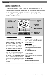
...Satellite Signal Strength Chart Clear bar indicates that are being used to get information from the horizon, or directly overhead. position computed is 3-dimensional (elevation is starting to compute your position. 42 Magellan Meridian GPS Receiver Satellites that the Meridian is being ...computed). Power Source Indicates the source of power being used and the strength of the received signal. Meridian is not being computed). 2D - Reference The ...
...Satellite Signal Strength Chart Clear bar indicates that are being used to get information from the horizon, or directly overhead. position computed is 3-dimensional (elevation is starting to compute your position. 42 Magellan Meridian GPS Receiver Satellites that the Meridian is being ...computed). Power Source Indicates the source of power being used and the strength of the received signal. Meridian is not being computed). 2D - Reference The ...

User Manual
Page 71
... Setup ENTER Highlight ENTER Map Datum Select Primary or ENTER Select ENTER Secondary Datum Default: Primary - WGS84 60 Magellan Meridian GPS Receiver If you may require additional information. Available coordinate systems are using a map or chart with your Meridian and the datums do not match, you are : Lat/Lon, UTM, OSGB, Irish, Swiss, Swedish, Finnish, German...
... Setup ENTER Highlight ENTER Map Datum Select Primary or ENTER Select ENTER Secondary Datum Default: Primary - WGS84 60 Magellan Meridian GPS Receiver If you may require additional information. Available coordinate systems are using a map or chart with your Meridian and the datums do not match, you are : Lat/Lon, UTM, OSGB, Irish, Swiss, Swedish, Finnish, German...

User Manual
Page 85
... of numbers (SEC) is expressed as 0-59 while DEG/ MIN/MM expresses the same value as hours/minutes/decimals. Any elevation displayed by the Meridian. 74 Magellan Meridian GPS Receiver It would be using.) What is the same. There are used to compute the position and at the same time. (You should always make sure.../MIN/SEC) and degrees/minutes/minutes (DEG/MIN/MMM or DEG/MIN/MM)? Which you choose is dependent upon your preference or any map or chart you may be the same as if you had one clock that expressed time as hour/minutes/seconds and another clock that your...
... of numbers (SEC) is expressed as 0-59 while DEG/ MIN/MM expresses the same value as hours/minutes/decimals. Any elevation displayed by the Meridian. 74 Magellan Meridian GPS Receiver It would be using.) What is the same. There are used to compute the position and at the same time. (You should always make sure.../MIN/SEC) and degrees/minutes/minutes (DEG/MIN/MMM or DEG/MIN/MM)? Which you choose is dependent upon your preference or any map or chart you may be the same as if you had one clock that expressed time as hour/minutes/seconds and another clock that your...
User Manual
Page 103
... the map. Refers to Steer. The value or setting automatically chosen by the unit unless otherwise directed. The direction the receiver is floating in marine charts) that projects from one datum to destination. Map makers may use WGS84. A unique numeric or alphanumeric description of a route.... The datum for the map you are using can be reached. Distance. Course Over Ground. Magellan Meridian GPS Receiver Estimated Time of which datum to use, use a different model to chart their maps, so position coordinates will be reported in Setup. If you are unsure of Arrival....
... the map. Refers to Steer. The value or setting automatically chosen by the unit unless otherwise directed. The direction the receiver is floating in marine charts) that projects from one datum to destination. Map makers may use WGS84. A unique numeric or alphanumeric description of a route.... The datum for the map you are using can be reached. Distance. Course Over Ground. Magellan Meridian GPS Receiver Estimated Time of which datum to use, use a different model to chart their maps, so position coordinates will be reported in Setup. If you are unsure of Arrival....

User Manual
Page 105
... 94 Magellan Meridian GPS Receiver Used to North Pole from an observer's position. Given as Greenwich Mean Time (GMT). Universal Time Coordinated. The perpendicular distance between the present position and the courseline. The north direction on most large and intermediate scale land topographic charts and ...maps. Cross Track Error. The component of the destination. A location saved in the receiver's memory which is in the direction of the velocity that is obtained by...
... 94 Magellan Meridian GPS Receiver Used to North Pole from an observer's position. Given as Greenwich Mean Time (GMT). Universal Time Coordinated. The perpendicular distance between the present position and the courseline. The north direction on most large and intermediate scale land topographic charts and ...maps. Cross Track Error. The component of the destination. A location saved in the receiver's memory which is in the direction of the velocity that is obtained by...