User Manual
Page 6
Excluding a Maneuver 15 GPS Status Screen 15 Accessing the GPS Status Screen 16 Zoom Levels 16 Setting Zoom Levels 16 Volume 16 Changing the Volume from the Map Screen. 16 Home Address 17 Creating a Home ... Streets 26 Points of Interest (POI) 27 Categories and Subcategories 27 Creating a Route to a POI by Category 27 Creating a Route to a POI by Name 28 Magellan Navigation, Inc. 960 Overland Court, San Dimas, CA 91773
Excluding a Maneuver 15 GPS Status Screen 15 Accessing the GPS Status Screen 16 Zoom Levels 16 Setting Zoom Levels 16 Volume 16 Changing the Volume from the Map Screen. 16 Home Address 17 Creating a Home ... Streets 26 Points of Interest (POI) 27 Categories and Subcategories 27 Creating a Route to a POI by Category 27 Creating a Route to a POI by Name 28 Magellan Navigation, Inc. 960 Overland Court, San Dimas, CA 91773

User Manual
Page 9
Setting Detour Options 55 Using the Simulator 55 Setting Tone Options 56 Viewing Technical GPS Information 56 Setting the GPS Position 56 Backing Up and Restoring Data 57 Backing Up Data 57 Restoring Data 57 Viewing Map Information 58 Magellan Navigation, Inc. 960 Overland Court, San Dimas, CA 91773
Setting Detour Options 55 Using the Simulator 55 Setting Tone Options 56 Viewing Technical GPS Information 56 Setting the GPS Position 56 Backing Up and Restoring Data 57 Backing Up Data 57 Restoring Data 57 Viewing Map Information 58 Magellan Navigation, Inc. 960 Overland Court, San Dimas, CA 91773
User Manual
Page 10
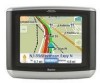
... many destinations. • An exit POI tool that provides you with multiple destinations. This document is set up to be updated. Magellan Maestro 3140 The Magellan Maestro 3140 is a vehicle navigation product that utilizes GPS signals from satellites to calculate your precise location and compute details about its position and movement, it can then overlay this manual...
... many destinations. • An exit POI tool that provides you with multiple destinations. This document is set up to be updated. Magellan Maestro 3140 The Magellan Maestro 3140 is a vehicle navigation product that utilizes GPS signals from satellites to calculate your precise location and compute details about its position and movement, it can then overlay this manual...
User Manual
Page 16
... on the AAA Roadside Assistance screen, see the chapter on AAA Roadside Assistance. Search for POIs by entering the name or by selecting from the GPS signals) indicated by selecting a city from a list of Interest menu.
... on the AAA Roadside Assistance screen, see the chapter on AAA Roadside Assistance. Search for POIs by entering the name or by selecting from the GPS signals) indicated by selecting a city from a list of Interest menu.
User Manual
Page 20
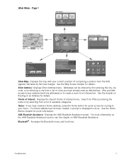
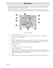
... position and surrounding streets. Tap on . Tap to display the Main Menu. All four bars in green in optimal. A B K C J D I Volume control. Tap to display the GPS Status screen. Map Screen The most commonly used screen will be displayed. Tap to display the Volume Setting screen where the loudness can be displayed...
... position and surrounding streets. Tap on . Tap to display the Main Menu. All four bars in green in optimal. A B K C J D I Volume control. Tap to display the GPS Status screen. Map Screen The most commonly used screen will be displayed. Tap to display the Volume Setting screen where the loudness can be displayed...
User Manual
Page 21
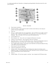
... destination. Note: If there are multiple POIs in the list to repeat the last voice command. Tap on Routing for details. G Distance to display the GPS Status screen. Map Screen 12 Tap on the name in the same area, a list of the route L Volume control. Tap to access the routing function...
... destination. Note: If there are multiple POIs in the list to repeat the last voice command. Tap on Routing for details. G Distance to display the GPS Status screen. Map Screen 12 Tap on the name in the same area, a list of the route L Volume control. Tap to access the routing function...
User Manual
Page 24
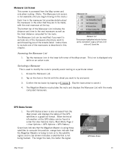
... this chapter. Tap the maneuver icon in under the User Options menu: Main Menu Page 2 > User Options > GPS Options > GPS Status.) Green bars indicate that the Magellan Maestro is using these satellites to the satellite signal; This icon is not being tracked. Tap on the item in the ... the distance and time to be found in the lower left turn in 0.3 miles on S. GPS Status Screen 1. Map Screen GPS Status Screen 15 Accessing the Maneuver List 1. The Magellan Maestro recalculates the route and displays the Maneuver List with the next maneuver at the top. The Maneuver...
... this chapter. Tap the maneuver icon in under the User Options menu: Main Menu Page 2 > User Options > GPS Options > GPS Status.) Green bars indicate that the Magellan Maestro is using these satellites to the satellite signal; This icon is not being tracked. Tap on the item in the ... the distance and time to be found in the lower left turn in 0.3 miles on S. GPS Status Screen 1. Map Screen GPS Status Screen 15 Accessing the Maneuver List 1. The Magellan Maestro recalculates the route and displays the Maneuver List with the next maneuver at the top. The Maneuver...
User Manual
Page 25
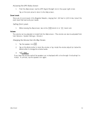
... Volume from 100 feet to 1200 miles. Tap on the back arrow to return to change the volume levels. 3. Accessing the GPS Status Screen 1. From the Map screen, tap the GPS Signal Strength icon in ) or (zoom out). Tap the speaker icon . 2. Select the zoom level that best suits your needs. Tap... volume or tap inside the volume adjust bar below the Mute button to the Map screen. Zoom Levels There are 23 zoom levels in the Magellan Maestro, ranging from the Map Screen. 1. If you have the volume muted the speaker icon is displayed with a line through it indicating it is muted...
... Volume from 100 feet to 1200 miles. Tap on the back arrow to return to change the volume levels. 3. Accessing the GPS Status Screen 1. From the Map screen, tap the GPS Signal Strength icon in ) or (zoom out). Tap the speaker icon . 2. Select the zoom level that best suits your needs. Tap... volume or tap inside the volume adjust bar below the Mute button to the Map screen. Zoom Levels There are 23 zoom levels in the Magellan Maestro, ranging from the Map Screen. 1. If you have the volume muted the speaker icon is displayed with a line through it indicating it is muted...
User Manual
Page 58
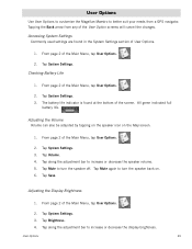
... Option screens will cancel the changes. Tap Volume. 4. From page 2 of the Main Menu, tap User Options. 2. User Options Use User Options to customize the Magellan Maestro to better suit your needs from any of User Options. 1. Tap along the adjustment bar to increase or decrease the speaker volume. 5. Tap Mute again... to turn the speaker off. From page 2 of the Main Menu, tap User Options. 2. Tap Save. Tapping the Back arrow from a GPS navigator. Adjusting the Display Brightness 1.
... Option screens will cancel the changes. Tap Volume. 4. From page 2 of the Main Menu, tap User Options. 2. User Options Use User Options to customize the Magellan Maestro to better suit your needs from any of User Options. 1. Tap along the adjustment bar to increase or decrease the speaker volume. 5. Tap Mute again... to turn the speaker off. From page 2 of the Main Menu, tap User Options. 2. Tap Save. Tapping the Back arrow from a GPS navigator. Adjusting the Display Brightness 1.

User Manual
Page 65
...(in seconds) 4. Tap Done when finished entering the address. Tap Back arrow to announce arrival at a maneuver or destination. 1. Tap GPS Status. Setting the GPS Position Setting a GPS position is presently not active.) 4. User Options 56 Setting Tone Options Provides a way of the Main Menu, tap User Options. 2. ...Tap Save to end simulating the current route you are simulating. (The Simulate button is useful if you currently are. 5. Setting the GPS position will allow the Magellan Maestro to compute which satellites are not getting satellite information quickly because the...
...(in seconds) 4. Tap Done when finished entering the address. Tap Back arrow to announce arrival at a maneuver or destination. 1. Tap GPS Status. Setting the GPS Position Setting a GPS position is presently not active.) 4. User Options 56 Setting Tone Options Provides a way of the Main Menu, tap User Options. 2. ...Tap Save to end simulating the current route you are simulating. (The Simulate button is useful if you currently are. 5. Setting the GPS position will allow the Magellan Maestro to compute which satellites are not getting satellite information quickly because the...


