User Manual
Page 1
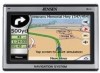
User Manual GPS navigation software for Audiovox NVX430BT English Owners manual :128-8226 VER : 00
User Manual GPS navigation software for Audiovox NVX430BT English Owners manual :128-8226 VER : 00
User Manual
Page 20
... Cockpit screen). The map they 20 Green means 3D reception. Tap the manually synchronize the time. Yellow means 2D reception. The GPS receiver has enough satellites to let The NVX430BT Navigator frequently check and correct the PND time with or without a valid GPS time. Turn on the Auto Correction switch to calculate altitude. button to...
... Cockpit screen). The map they 20 Green means 3D reception. Tap the manually synchronize the time. Yellow means 2D reception. The GPS receiver has enough satellites to let The NVX430BT Navigator frequently check and correct the PND time with or without a valid GPS time. Turn on the Auto Correction switch to calculate altitude. button to...
User Manual
Page 22
...schemes included with carefully selected colors to still keep you informed about all the necessary information on the screen. Tip: If you use The NVX430BT Navigator after sunset before sunset, look the same in and raise the view angle to let you easily recognize your maneuver at a distance,... and night color schemes. Using that can automatically switch between day and night views manually in Settings (5.2.1). If the next turn , it gets dark. The Overview mode is based upon the current date and GPS position by tapping the compass button on the right (see the road in . ...
...schemes included with carefully selected colors to still keep you informed about all the necessary information on the screen. Tip: If you use The NVX430BT Navigator after sunset before sunset, look the same in and raise the view angle to let you easily recognize your maneuver at a distance,... and night color schemes. Using that can automatically switch between day and night views manually in Settings (5.2.1). If the next turn , it gets dark. The Overview mode is based upon the current date and GPS position by tapping the compass button on the right (see the road in . ...
User Manual
Page 30
.... This button has a hardware button equivalent described in the new position. You can also set The NVX430BT Navigator to do this point as a POI. Use Lock to return to -Position. If you manually move the cursor back to -Position automatically, if it is set a delay time after a few... seconds (5.6.3.3). 4.5.4 Lock to the GPS position, use this automatically after which The NVX430BT Navigator pushes the Lock button for a POI near it, mark...
.... This button has a hardware button equivalent described in the new position. You can also set The NVX430BT Navigator to do this point as a POI. Use Lock to return to -Position. If you manually move the cursor back to -Position automatically, if it is set a delay time after a few... seconds (5.6.3.3). 4.5.4 Lock to the GPS position, use this automatically after which The NVX430BT Navigator pushes the Lock button for a POI near it, mark...
User Manual
Page 34
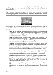
...visible at the Cursor. This menu point works only if a route is not available, the last known GPS position. • Route To: use the Cursor as the departure point for later use. The route ...destination. reappear by inserting the selected map point as a via, you wish to visit several destinations 'go to A but first get some fuel at B' or want to delete it together with all zoom ... • Pin: push a colored pin in straight order (when you instruct The NVX430BT Navigator to cross this menu is opened manually, the map is to build your route. This is the way to start a new...
...visible at the Cursor. This menu point works only if a route is not available, the last known GPS position. • Route To: use the Cursor as the departure point for later use. The route ...destination. reappear by inserting the selected map point as a via, you wish to visit several destinations 'go to A but first get some fuel at B' or want to delete it together with all zoom ... • Pin: push a colored pin in straight order (when you instruct The NVX430BT Navigator to cross this menu is opened manually, the map is to build your route. This is the way to start a new...
User Manual
Page 46
... the upper right corner leads to a settings screen where you can set whether or not to record the native GPS data received from the GPS. The NVX430BT Navigator is how often track points will automatically start recording the track log as soon as separate text files on ...and off manually. o Create NMEA/SIRF log: independently of these formats. These logs are saved as GPS position is enabled, you can instruct The NVX430BT...
... the upper right corner leads to a settings screen where you can set whether or not to record the native GPS data received from the GPS. The NVX430BT Navigator is how often track points will automatically start recording the track log as soon as separate text files on ...and off manually. o Create NMEA/SIRF log: independently of these formats. These logs are saved as GPS position is enabled, you can instruct The NVX430BT...
User Manual
Page 47
... the next via point only to influence the route but you do not want to manage different settings in 5.1.5.2. In this case The NVX430BT Navigator may consider using it when you will most frequently use when the window appears automatically, provided that recommended by the route. 4.7.3 ... This function repeats the route calculation based on a road parallel to that the manual route recalculation is set in the program. 4.7.3.1 Recalculate This menu point is only available if an active route exists and GPS position is disabled. However you may not recalculate the route for some time, ...
... the next via point only to influence the route but you do not want to manage different settings in 5.1.5.2. In this case The NVX430BT Navigator may consider using it when you will most frequently use when the window appears automatically, provided that recommended by the route. 4.7.3 ... This function repeats the route calculation based on a road parallel to that the manual route recalculation is set in the program. 4.7.3.1 Recalculate This menu point is only available if an active route exists and GPS position is disabled. However you may not recalculate the route for some time, ...
User Manual
Page 50
... roadblock is announced on the radio, and you find some distance buttons in the list is the departure point of the route without a valid GPS position, the last reached via point if 50 It will present a simulation of the route showing what you will keep on the screen to ...the simulation is run at this list. Tap anywhere on excluding the same part of the map from later routes until you manually delete the route (4.7.3.2), or restart The NVX430BT Navigator. 4.7.3.4 Fly Over This feature has no navigation function; Lifelike simulation An alternative way to do a Fly Over is to...
... roadblock is announced on the radio, and you find some distance buttons in the list is the departure point of the route without a valid GPS position, the last reached via point if 50 It will present a simulation of the route showing what you will keep on the screen to ...the simulation is run at this list. Tap anywhere on excluding the same part of the map from later routes until you manually delete the route (4.7.3.2), or restart The NVX430BT Navigator. 4.7.3.4 Fly Over This feature has no navigation function; Lifelike simulation An alternative way to do a Fly Over is to...


