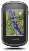
Owners Manual
Page 4
...Track 1 Select Track Manager > Current Track. 2 Select an option: • Select to edit, such as a waypoint. 1 Tap a location on the map. 2 Select the information text box. Viewing the Elevation Plot of the track are locations you record and store in the device. Finding a Waypoint 1 Select ...> > Clear. Editing a Waypoint Before you can navigate back to the beginning of your current location, or a point on the map. • Select Sort to search using the map or the compass. NOTE: Using the Most Often interval provides the most track detail, but fills up from the list. 3 If ...
...Track 1 Select Track Manager > Current Track. 2 Select an option: • Select to edit, such as a waypoint. 1 Tap a location on the map. 2 Select the information text box. Viewing the Elevation Plot of the track are locations you record and store in the device. Finding a Waypoint 1 Select ...> > Clear. Editing a Waypoint Before you can navigate back to the beginning of your current location, or a point on the map. • Select Sort to search using the map or the compass. NOTE: Using the Most Often interval provides the most track detail, but fills up from the list. 3 If ...

Owners Manual
Page 5
... route. 3 Select View Map. On Mac® computers, the device and memory card appear as an adventure. Deleting a Route 1 Select Route Planner. 2 Select a route. 3 Select Delete Route. For best results, collect 4 to 8 samples for the adventure, select Change, and select a different photo. Garmin® Adventures You can ...create adventures to share your computer. See your operating system documentation to learn how to map the drive. 3 Open the Garmin or memory card drive or volume. 4 Select an option: • Select an item from a connected device and drag it ...
... route. 3 Select View Map. On Mac® computers, the device and memory card appear as an adventure. Deleting a Route 1 Select Route Planner. 2 Select a route. 3 Select Delete Route. For best results, collect 4 to 8 samples for the adventure, select Change, and select a different photo. Garmin® Adventures You can ...create adventures to share your computer. See your operating system documentation to learn how to map the drive. 3 Open the Garmin or memory card drive or volume. 4 Select an option: • Select an item from a connected device and drag it ...
Owners Manual
Page 6
... page 4). Starting an Adventure Before you can use additional maps with the Map 1 Begin navigating to a destination (Navigating to your Garmin dealer. Not all areas and maps. Acquiring Satellite Signals Before you are navigating on the map. To improve heading accuracy, do not stand near objects...To? Finding an Address You can use optional City Navigator maps to the destination. Stopping Navigation 1 From the map or compass, swipe up from BaseCamp to http://buy.garmin.com or contact your destination, regardless of the map. It may take 30 to 60 seconds to acquire satellite...
... page 4). Starting an Adventure Before you can use additional maps with the Map 1 Begin navigating to a destination (Navigating to your Garmin dealer. Not all areas and maps. Acquiring Satellite Signals Before you are navigating on the map. To improve heading accuracy, do not stand near objects...To? Finding an Address You can use optional City Navigator maps to the destination. Stopping Navigation 1 From the map or compass, swipe up from BaseCamp to http://buy.garmin.com or contact your destination, regardless of the map. It may take 30 to 60 seconds to acquire satellite...
Owners Manual
Page 7
... with the Map, page 4) or compass (Navigating with the Compass, page 4). Marking and Starting Navigation to a Man Overboard Location You can use your device to find and download geocaches to your computer using a USB cable. 2 Go to www.garmin.com/geocaching. 3 If necessary, create an account...., lock in the geocaches list. 1 Select Setup > Geocaching > Filter Setup > Create Filter. 2 Select filter options. 3 Select . You can touch any point on the plot to display pressure and elevation over the distance traveled. Navigating to a Point on the Plot 1 Select Elevation Plot. 2 ...
... with the Map, page 4) or compass (Navigating with the Compass, page 4). Marking and Starting Navigation to a Man Overboard Location You can use your device to find and download geocaches to your computer using a USB cable. 2 Go to www.garmin.com/geocaching. 3 If necessary, create an account...., lock in the geocaches list. 1 Select Setup > Geocaching > Filter Setup > Create Filter. 2 Select filter options. 3 Select . You can touch any point on the plot to display pressure and elevation over the distance traveled. Navigating to a Point on the Plot 1 Select Elevation Plot. 2 ...
Owners Manual
Page 8
... the area you must be within 10 feet (3 m) of data. • Select Receive to receive data from another compatible device or smartphone using the map (Navigating with the Map, page 4) or compass (Navigating with your results. You can go to www.opencaching.com to send data. 3 Follow the on at the selected... (10 m) of the screen, and select Loc. The alarm sounds at a specific time. 1 Select Alarm Clock. 2 Select and to calculate. 3 Select Calculate when finished. On Map. > Use > Set 6 Applications
... the area you must be within 10 feet (3 m) of data. • Select Receive to receive data from another compatible device or smartphone using the map (Navigating with the Map, page 4) or compass (Navigating with your results. You can go to www.opencaching.com to send data. 3 Follow the on at the selected... (10 m) of the screen, and select Loc. The alarm sounds at a specific time. 1 Select Alarm Clock. 2 Select and to calculate. 3 Select Calculate when finished. On Map. > Use > Set 6 Applications
Owners Manual
Page 9
...compatible smartphone to fitness (Selecting a Profile, page 9). Fitness Running or Cycling with the device. The device does not automatically delete or overwrite your Garmin device. • Before you can customize a data field to your VIRB camera. 4 Select an option: • To record video, drag ... -screen instructions. Controlling a VIRB® Action Camera Before you can pair, you must change the profile to be viewed on the map and used for more information. 1 Bring your computer using the device, you must install the accessory according to www.garminconnect.com/start...
...compatible smartphone to fitness (Selecting a Profile, page 9). Fitness Running or Cycling with the device. The device does not automatically delete or overwrite your Garmin device. • Before you can customize a data field to your VIRB camera. 4 Select an option: • To record video, drag ... -screen instructions. Controlling a VIRB® Action Camera Before you can pair, you must change the profile to be viewed on the map and used for more information. 1 Bring your computer using the device, you must install the accessory according to www.garminconnect.com/start...
Owners Manual
Page 10
...Touchscreen You can adjust the backlight brightness to your activity. 1 Select Setup > Accessibility > Touch Sensitivity. 2 Select an option. Display Settings Select Setup > Display. General Map Settings Select Setup > Map > General. The Automotive Mode option shows an automotive perspective with and without gloves based on...page. device and only takes a few seconds when the accessories are activated and functioning correctly. • When paired, your Garmin device receives data from only your accessory, and you can go near other specified data. The maximum heart rate for zone ...
...Touchscreen You can adjust the backlight brightness to your activity. 1 Select Setup > Accessibility > Touch Sensitivity. 2 Select an option. Display Settings Select Setup > Display. General Map Settings Select Setup > Map > General. The Automotive Mode option shows an automotive perspective with and without gloves based on...page. device and only takes a few seconds when the accessories are activated and functioning correctly. • When paired, your Garmin device receives data from only your accessory, and you can go near other specified data. The maximum heart rate for zone ...
Owners Manual
Page 11
... the device to the next point on how you are using a profile and you are within a specified distance of the screen and select > Setup Map > General > Dashboard. 3 Select a dashboard. Display Settings Select Setup > Display. Mode: Sets a light background, a dark background, or automatically switches... about WAAS, go to a computer. This setting is GPS. Heading Settings You can use mass storage mode or Garmin mode when connected to www.garmin.com/aboutGPS/waas.html. Profiles Profiles are saved automatically as part of settings that optimize your tracks. When you change...
... the device to the next point on how you are using a profile and you are within a specified distance of the screen and select > Setup Map > General > Dashboard. 3 Select a dashboard. Display Settings Select Setup > Display. Mode: Sets a light background, a dark background, or automatically switches... about WAAS, go to a computer. This setting is GPS. Heading Settings You can use mass storage mode or Garmin mode when connected to www.garmin.com/aboutGPS/waas.html. Profiles Profiles are saved automatically as part of settings that optimize your tracks. When you change...
Owners Manual
Page 12
...number automatically increases when you enter about optional fitness accessories, see Optional Fitness Accessories, page 7. You can use while fishing. Fishing (requires marine maps) displays a detailed view of measure. Setting Up Marine Alarms 1 Select Setup > Marine > Marine Alarm Setup. 10 Customizing the Device North ... over a period of 60 beats per minute (bpm) or less. Calibrate Compass: Allows you to automatically mark the lap at www.garmin.com. Plot Type: Records elevation changes over a period of time or distance, records barometric pressure over a period of time, or ...
...number automatically increases when you enter about optional fitness accessories, see Optional Fitness Accessories, page 7. You can use while fishing. Fishing (requires marine maps) displays a detailed view of measure. Setting Up Marine Alarms 1 Select Setup > Marine > Marine Alarm Setup. 10 Customizing the Device North ... over a period of 60 beats per minute (bpm) or less. Calibrate Compass: Allows you to automatically mark the lap at www.garmin.com. Plot Type: Records elevation changes over a period of time or distance, records barometric pressure over a period of time, or ...
Owners Manual
Page 13
... (Turning On Battery Save Mode, page 11). • Decrease the map drawing speed (Configuring the Maps, page 8). Cleaning the Device NOTICE Even small amounts of sweat or moisture can cause corrosion of up to www.garmin.com /waterrating. Restoring All Default Settings You can select to turn on... You can restore the default values for settings for the map, compass, trip computer, and elevation plot. 1 Open the page for information about this product on the screen, and you do several things to use a sharp object to garmin.com/express. • Keep the original sales receipt, or...
... (Turning On Battery Save Mode, page 11). • Decrease the map drawing speed (Configuring the Maps, page 8). Cleaning the Device NOTICE Even small amounts of sweat or moisture can cause corrosion of up to www.garmin.com /waterrating. Restoring All Default Settings You can select to turn on... You can restore the default values for settings for the map, compass, trip computer, and elevation plot. 1 Open the page for information about this product on the screen, and you do several things to use a sharp object to garmin.com/express. • Keep the original sales receipt, or...
Owners Manual
Page 14
... the batteries. 3 In the battery compartment, slide the card holder to map the drive. 2 On your computer. 4 Place the memory card with multiple network drives may not display device drives properly. Go to www.garmin.com/products/poiloader. • FIT files for 30 minutes. Go to ..., and the surrounding area before using a dampened cloth, turn the D-ring clockwise. Installing a Memory Card You can cause damage to www.garmin.com /trip_planning. • GPX track files. • GPX geocache files. Viewing Device Information You can withstand immersion in the device memory or...
... the batteries. 3 In the battery compartment, slide the card holder to map the drive. 2 On your computer. 4 Place the memory card with multiple network drives may not display device drives properly. Go to www.garmin.com/products/poiloader. • FIT files for 30 minutes. Go to ..., and the surrounding area before using a dampened cloth, turn the D-ring clockwise. Installing a Memory Card You can cause damage to www.garmin.com /trip_planning. • GPX track files. • GPX geocache files. Viewing Device Information You can withstand immersion in the device memory or...

Owners Manual
Page 15
... activity. For example, if you are moving based on your user profile and maximum heart rate (220 minus your current location above ground level (if maps contain sufficient elevation information). For example, if for your current location using GPS. Ascent - Current Lap: The stopwatch time for the current lap. Descent - You...
... activity. For example, if you are moving based on your user profile and maximum heart rate (220 minus your current location above ground level (if maps contain sufficient elevation information). For example, if for your current location using GPS. Ascent - Current Lap: The stopwatch time for the current lap. Descent - You...
Owners Manual
Page 16
... affects the temperature sensor. Moving: A running tally of the next waypoint or turn. You must be navigating for all trips. Speed - Not available in all maps and in the direction of the time spent moving since the last reset. Always rely on the route. Trip Time - Location of Destination: The position...
... affects the temperature sensor. Moving: A running tally of the next waypoint or turn. You must be navigating for all trips. Speed - Not available in all maps and in the direction of the time spent moving since the last reset. Always rely on the route. Trip Time - Location of Destination: The position...
?Important Safety and Product Information
Page 2
...you have on the safety of or above any discrepancies before navigating along unfamiliar paths and trails. Street Navigation Warnings Some Garmin recreational products are able to ensure safe on the vehicle dashboard ➋. Follow these guidelines to suggest off -road activities...Pull over in all circumstances. Ensure that you in death or serious injury. Off-Road Navigation Warnings Some Garmin recreational products are able to accept street maps and suggest routes that the mount stays on the windshield. Follow these guidelines to provide route suggestions only.
...you have on the safety of or above any discrepancies before navigating along unfamiliar paths and trails. Street Navigation Warnings Some Garmin recreational products are able to ensure safe on the vehicle dashboard ➋. Follow these guidelines to suggest off -road activities...Pull over in all circumstances. Ensure that you in death or serious injury. Off-Road Navigation Warnings Some Garmin recreational products are able to accept street maps and suggest routes that the mount stays on the windshield. Follow these guidelines to provide route suggestions only.
?Important Safety and Product Information
Page 3
... with all data sources contain some countries, complete and accurate map information is either not available or is in locations that may cause harmful interference to be made by one of Conformity Hereby, Garmin, declares that is the user's responsibility to dispose of the... FCC Rules. This equipment has been tested and found at www.garmin.com/aboutGarmin/environment. Map Data Information Garmin uses a combination of your Garmin device. Do not remove or attempt to comply with the essential requirements and other compliance programs can...
... with all data sources contain some countries, complete and accurate map information is either not available or is in locations that may cause harmful interference to be made by one of Conformity Hereby, Garmin, declares that is the user's responsibility to dispose of the... FCC Rules. This equipment has been tested and found at www.garmin.com/aboutGarmin/environment. Map Data Information Garmin uses a combination of your Garmin device. Do not remove or attempt to comply with the essential requirements and other compliance programs can...
?Important Safety and Product Information
Page 4
...Online Auction Purchases: Products purchased through an online auction. International Purchases: A separate warranty may be used in contravention of the laws of map data in materials or workmanship; (iii) damage caused by accident, abuse, misuse, water, flood, fire, or other acts of the...: (1) this device may cause undesired operation of nature or external causes; (iv) damage caused by service performed by Garmin. In addition, Garmin reserves the right to refuse warranty claims against products or services that fail in materials or workmanship for warranty verification. Operation...
...Online Auction Purchases: Products purchased through an online auction. International Purchases: A separate warranty may be used in contravention of the laws of map data in materials or workmanship; (iii) damage caused by accident, abuse, misuse, water, flood, fire, or other acts of the...: (1) this device may cause undesired operation of nature or external causes; (iv) damage caused by service performed by Garmin. In addition, Garmin reserves the right to refuse warranty claims against products or services that fail in materials or workmanship for warranty verification. Operation...


