Important Product and Safety Information (Multilingual)
Page 2
Do not mount in death or serious injury. See www.garmin.com/prop65 for various purposes, such as the steering wheel, foot pedals, or transmission levers. In addition, the GPS unit may use voice prompts when possible. Do not become distracted by the ...traffic congestion, weather conditions, or other factors that may present a risk of deployment. • When navigating, carefully compare information displayed on field of all available navigation sources, including information from children. • Do not disassemble, puncture, or damage the batteries. • Only...
Do not mount in death or serious injury. See www.garmin.com/prop65 for various purposes, such as the steering wheel, foot pedals, or transmission levers. In addition, the GPS unit may use voice prompts when possible. Do not become distracted by the ...traffic congestion, weather conditions, or other factors that may present a risk of deployment. • When navigating, carefully compare information displayed on field of all available navigation sources, including information from children. • Do not disassemble, puncture, or damage the batteries. • Only...
Owner's Manual
Page 11
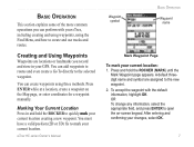
.... Marking Your Current Location Press in your eTrex, including creating and using waypoints, using three methods. To accept the waypoint with your GPS. OR To change any information, select the appropriate field, and press ENTER to quickly mark your ...current location. You must have a valid position (2D or 3D) fix to the selected waypoint. You can add waypoints to routes and even create a Go To directly to mark your current location creating a new waypoint. eTrex HC...
.... Marking Your Current Location Press in your eTrex, including creating and using waypoints, using three methods. To accept the waypoint with your GPS. OR To change any information, select the appropriate field, and press ENTER to quickly mark your ...current location. You must have a valid position (2D or 3D) fix to the selected waypoint. You can add waypoints to routes and even create a Go To directly to mark your current location creating a new waypoint. eTrex HC...
Owner's Manual
Page 19
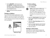
...the exit to the highlighted service. 4. Addresses icon Addresses Page Basic Operation To find feature matches that data with your unit has a GPS fix, the field is populated with addresses in the , because the database has information for an intersection. You do not have to find an address. ...Select OK. 4 Select the field. A list of available services near the exit, and the distance and bearing from the list, and press ENTER. Select the address. eTrex HC series Owner's Manual 15 This page contains the exit description, a list of ...
...the exit to the highlighted service. 4. Addresses icon Addresses Page Basic Operation To find feature matches that data with your unit has a GPS fix, the field is populated with addresses in the , because the database has information for an intersection. You do not have to find an address. ...Select OK. 4 Select the field. A list of available services near the exit, and the distance and bearing from the list, and press ENTER. Select the address. eTrex HC series Owner's Manual 15 This page contains the exit description, a list of ...
Owner's Manual
Page 28
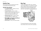
... more than 600 miles (1,000 km). • GPS Elevation-shows your current elevation. Satellite Page Options • Use With GPS Off/On-enables you to turn the unit on this page. Data fields Show menu Map Page with data fields Two map operating modes, position mode and pan mode... and mapping data is accessed from the Main Menu thereafter. Main Pages Satellite Page This page appears when you turn the GPS receiver on the map display. 24 eTrex HC series Owner's Manual Map Page A built-in basemap that includes cities, interstates, state and county highways, exit information, ...
... more than 600 miles (1,000 km). • GPS Elevation-shows your current elevation. Satellite Page Options • Use With GPS Off/On-enables you to turn the unit on this page. Data fields Show menu Map Page with data fields Two map operating modes, position mode and pan mode... and mapping data is accessed from the Main Menu thereafter. Main Pages Satellite Page This page appears when you turn the GPS receiver on the map display. 24 eTrex HC series Owner's Manual Map Page A built-in basemap that includes cities, interstates, state and county highways, exit information, ...

Owner's Manual
Page 32
... operates like a magnetic compass when you are near objects that affect magnetic fields, such as cars or buildings. 28 eTrex HC series Owner's Manual The accuracy of the eTrex HC series units use a GPS data driven compass but only the Vista HCx and Summit HC have an additional electronic compass.) When you press and hold QUIT on these...
... operates like a magnetic compass when you are near objects that affect magnetic fields, such as cars or buildings. 28 eTrex HC series Owner's Manual The accuracy of the eTrex HC series units use a GPS data driven compass but only the Vista HCx and Summit HC have an additional electronic compass.) When you press and hold QUIT on these...

Owner's Manual
Page 39
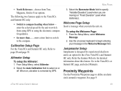
...do not know the elevation, select No to use the default GPS elevation. 3. Trip Computer Page Each data field is selected, press ENTER to use the pressure option. Highlight Apply...The Correct Elevation?" Select OK. When the data field title is selectable and can fluctuate, calibrate the altimeter to reset the data fields. A confirmation message appears. Calibrating the Altimeter ...of navigation data. Main Pages 3. Choosing Big Numbers arranges the page in three large data fields. Press Menu > Calibrate Altimeter. 2. If you are ready to enter the new elevation...
...do not know the elevation, select No to use the default GPS elevation. 3. Trip Computer Page Each data field is selected, press ENTER to use the pressure option. Highlight Apply...The Correct Elevation?" Select OK. When the data field title is selectable and can fluctuate, calibrate the altimeter to reset the data fields. A confirmation message appears. Calibrating the Altimeter ...of navigation data. Main Pages 3. Choosing Big Numbers arranges the page in three large data fields. Press Menu > Calibrate Altimeter. 2. If you are ready to enter the new elevation...
Owner's Manual
Page 47
... is designed for experienced skydivers and is corrected by GPS. Proximity Waypoints Use the Proximity Waypoints page to select on , elevation is an option for the eTrex Vista HCx and Summit HC only. Select the Auto Calibration field to define an alarm circle around a waypoint. Refer the Garmin Web site for the unit to switch from...
... is designed for experienced skydivers and is corrected by GPS. Proximity Waypoints Use the Proximity Waypoints page to select on , elevation is an option for the eTrex Vista HCx and Summit HC only. Select the Auto Calibration field to define an alarm circle around a waypoint. Refer the Garmin Web site for the unit to switch from...
Quick Reference Guide
Page 1
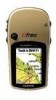
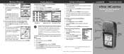
... Garmin Ltd. or its subsidiaries Printed in Taiwan Quick Start Guide eTrex® HC series Vista HCx, Legend HCx, Summit HC, and Venture HC GPS antenna... IN/OUT (Zoom) keys ENTER/ROCKER key MENU/FIND key QUIT/ PAGE key POWER/ Backlight key Color LCD display (eTrex Vista HCx shown) (eTrex... map data must be downloaded to the eTrex (Summit HC and Venture HC) or a microSD™ or TransFlash™...a waypoint, and press ENTER. 4. Please visit www.garmin.com for detailed information.) To find an item from your...
... Garmin Ltd. or its subsidiaries Printed in Taiwan Quick Start Guide eTrex® HC series Vista HCx, Legend HCx, Summit HC, and Venture HC GPS antenna... IN/OUT (Zoom) keys ENTER/ROCKER key MENU/FIND key QUIT/ PAGE key POWER/ Backlight key Color LCD display (eTrex Vista HCx shown) (eTrex... map data must be downloaded to the eTrex (Summit HC and Venture HC) or a microSD™ or TransFlash™...a waypoint, and press ENTER. 4. Please visit www.garmin.com for detailed information.) To find an item from your...
Quick Reference Guide
Page 2
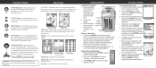
...and shows the GPS receiver status, satellite locations, satellite signal strength, and the receiver's current location. or to begin GPS-aided navigation. Compass Page Altimeter Page (Vista HCx/Summit HC only) Compass...page for satellite signals. Follow the instructions at start -up or down to turn on the eTrex: 1. From any time, press MENU, select Stop Navigation, and press ENTER. Press and...points. 6. To stop navigation at the top of the area around your destination. select fields, on -screen messages. Turn the D-Ring 1/4 turn clockwise to the list of the ...
...and shows the GPS receiver status, satellite locations, satellite signal strength, and the receiver's current location. or to begin GPS-aided navigation. Compass Page Altimeter Page (Vista HCx/Summit HC only) Compass...page for satellite signals. Follow the instructions at start -up or down to turn on the eTrex: 1. From any time, press MENU, select Stop Navigation, and press ENTER. Press and...points. 6. To stop navigation at the top of the area around your destination. select fields, on -screen messages. Turn the D-Ring 1/4 turn clockwise to the list of the ...

