Aviation Quick Reference Guide
Page 12
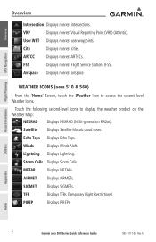
...ARTCCs. METAR Displays METARs. VRP Displays nearest Visual Reporting Point (VRP) (Atlantic). Winds Displays Winds Aloft. SIGMET Displays SIGMETs. Utilities Appendix Index 6 Garmin aera 500 Series Quick Reference Guide 190-01117-03 Rev. AIRMET Displays AIRMETs. Airspace ...Displays nearest airspace. Storm Cells Displays Storm Cells. PIREP Displays PIREPs. City Displays nearest cities. A Overview GPS Navigation Hazard Avoidance ...
...ARTCCs. METAR Displays METARs. VRP Displays nearest Visual Reporting Point (VRP) (Atlantic). Winds Displays Winds Aloft. SIGMET Displays SIGMETs. Utilities Appendix Index 6 Garmin aera 500 Series Quick Reference Guide 190-01117-03 Rev. AIRMET Displays AIRMETs. Airspace ...Displays nearest airspace. Storm Cells Displays Storm Cells. PIREP Displays PIREPs. City Displays nearest cities. A Overview GPS Navigation Hazard Avoidance ...

Pilot's Guide
Page 21
... nearest airport weather. VRP Displays nearest Visual Reporting Point (VRP) (Atlantic). FSS Displays nearest Flight Service Stations (FSS). Airspace Displays nearest airspace. 190-01117-02 Rev. NDB Displays nearest NDBs. User WPT Displays nearest user waypoints. A Garmin aera 500 Series Pilot's Guide 9 Index Overview GPS Navigation Flight Planning Hazard Avoidance Additional Features Appendices Touch the...
... nearest airport weather. VRP Displays nearest Visual Reporting Point (VRP) (Atlantic). FSS Displays nearest Flight Service Stations (FSS). Airspace Displays nearest airspace. 190-01117-02 Rev. NDB Displays nearest NDBs. User WPT Displays nearest user waypoints. A Garmin aera 500 Series Pilot's Guide 9 Index Overview GPS Navigation Flight Planning Hazard Avoidance Additional Features Appendices Touch the...
Pilot's Guide
Page 61
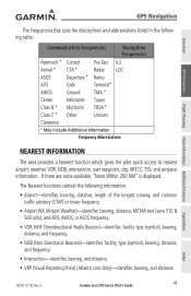
.... A Garmin aera 500 Series Pilot's Guide 49 If there are none available, "None Within 200 NM" is displayed. Overview GPS Navigation Flight Planning Hazard Avoidance Additional Features GPS Navigation The...aera 510 & 560 only), and ATIS, AWOS, or ASOS frequency. • VOR (VHF Omnidirectional Radio Beacon)-identifier, facility type (symbol), bearing, distance, and frequency. • NDB (Non Directional Beacons)-identifier, facility, type (symbol), bearing, distance, and frequency. • Intersection-identifier, bearing, and distance. • VRP (Visual Reporting Point) (Atlantic...
.... A Garmin aera 500 Series Pilot's Guide 49 If there are none available, "None Within 200 NM" is displayed. Overview GPS Navigation Flight Planning Hazard Avoidance Additional Features GPS Navigation The...aera 510 & 560 only), and ATIS, AWOS, or ASOS frequency. • VOR (VHF Omnidirectional Radio Beacon)-identifier, facility type (symbol), bearing, distance, and frequency. • NDB (Non Directional Beacons)-identifier, facility, type (symbol), bearing, distance, and frequency. • Intersection-identifier, bearing, and distance. • VRP (Visual Reporting Point) (Atlantic...

Pilot's Guide
Page 117
...happen most often. The SafeTaxi feature can be seen on the unit. Appendices Index 190-01117-02 Rev. A Garmin aera 500 Series Pilot's Guide 105 When viewing at close enough to show the airport detail, the map reveals taxiways with ... recognized at lower map ranges. Additional Features aera 500 510 550 560 GPS Navigation Americas Atlantic Pacific Americas Americas Atlantic Pacific Americas Flight Planning Hazard Avoidance Additional Features AOPA Airport Directory SafeTaxi® XM® + + + + + + aera 500/510/550/560 Additional Features 5.1 SafeTaxi SafeTaxi...
...happen most often. The SafeTaxi feature can be seen on the unit. Appendices Index 190-01117-02 Rev. A Garmin aera 500 Series Pilot's Guide 105 When viewing at close enough to show the airport detail, the map reveals taxiways with ... recognized at lower map ranges. Additional Features aera 500 510 550 560 GPS Navigation Americas Atlantic Pacific Americas Americas Atlantic Pacific Americas Flight Planning Hazard Avoidance Additional Features AOPA Airport Directory SafeTaxi® XM® + + + + + + aera 500/510/550/560 Additional Features 5.1 SafeTaxi SafeTaxi...
Pilot's Guide
Page 143
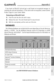
... Atlantic Pacific Americas Worldwide Basemap ++++++++ AOPA Airport Directory + + Air Sport Sites + Jeppesen® Aviation Database SafeTaxi® + + Obstacle ++ +++ + Terrain (arc-second) 30 30 30 30 9 9 9 9 XM® + + aera 500/510/550/560 Features & Databases Appendices Index 190-01117-02 Rev. If the card is still not recognized, contact Garmin Product Support or your Garmin dealer. A Garmin aera 500...
... Atlantic Pacific Americas Worldwide Basemap ++++++++ AOPA Airport Directory + + Air Sport Sites + Jeppesen® Aviation Database SafeTaxi® + + Obstacle ++ +++ + Terrain (arc-second) 30 30 30 30 9 9 9 9 XM® + + aera 500/510/550/560 Features & Databases Appendices Index 190-01117-02 Rev. If the card is still not recognized, contact Garmin Product Support or your Garmin dealer. A Garmin aera 500...
Pilot's Guide
Page 179
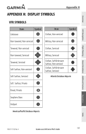
A Garmin aera 500 Series Pilot's Guide 167 Overview GPS Navigation Flight Planning Hazard Avoidance Additional Features Appendix H: Display Symbols Appendix H VFR Symbols Item Unknown Symbol Item Civilian, Non-serviced Symbol Non-towered...Serviced Towered, Serviced Soft Surface, Non-serviced Soft Surface, Serviced Military, Serviced Civilian, Soft/Unknown Surface, Non-serviced Civilian, Soft/Unknown Surface, Serviced Atlantic Database Airports Soft Surface, Private Paved, Private Seaplane Base Heliport Americas/Pacific Database Airports Appendices Index 190-01117-02 Rev.
A Garmin aera 500 Series Pilot's Guide 167 Overview GPS Navigation Flight Planning Hazard Avoidance Additional Features Appendix H: Display Symbols Appendix H VFR Symbols Item Unknown Symbol Item Civilian, Non-serviced Symbol Non-towered...Serviced Towered, Serviced Soft Surface, Non-serviced Soft Surface, Serviced Military, Serviced Civilian, Soft/Unknown Surface, Non-serviced Civilian, Soft/Unknown Surface, Serviced Atlantic Database Airports Soft Surface, Private Paved, Private Seaplane Base Heliport Americas/Pacific Database Airports Appendices Index 190-01117-02 Rev.

Pilot's Guide
Page 180
Overview GPS Navigation Appendix H Item Intersection Symbol Item Interstate Highway Symbol Visual Reporting Point LOM (compass locator at outer marker) NDB (non-directional radio beacon) VOR US ... Miscellaneous TACAN Navaids Additional Features Hazard Avoidance Flight Planning Appendices IFR Symbols Item Symbol VFR, Soft/unknown Surface, Non-serviced VFR, Soft/unknown Surface, Serviced Atlantic Database Airports Item Low-Altitude Symbol High- Altitude Airways 168 Garmin aera 500 Series Pilot's Guide 190-01117-02 Rev. A Index
Overview GPS Navigation Appendix H Item Intersection Symbol Item Interstate Highway Symbol Visual Reporting Point LOM (compass locator at outer marker) NDB (non-directional radio beacon) VOR US ... Miscellaneous TACAN Navaids Additional Features Hazard Avoidance Flight Planning Appendices IFR Symbols Item Symbol VFR, Soft/unknown Surface, Non-serviced VFR, Soft/unknown Surface, Serviced Atlantic Database Airports Item Low-Altitude Symbol High- Altitude Airways 168 Garmin aera 500 Series Pilot's Guide 190-01117-02 Rev. A Index

Pilot's Guide
Page 183
Overview Appendix H Item Danger or Alert Area Restricted, Prohibited, or Warning Area Training Area Symbol Item Training Area Symbol IFR Atlantic Database Exceptions VFR Atlantic Database Exceptions GPS Navigation Flight Planning Hazard Avoidance Additional Features Appendices Index 190-01117-02 Rev. A Garmin aera 500 Series Pilot's Guide 171
Overview Appendix H Item Danger or Alert Area Restricted, Prohibited, or Warning Area Training Area Symbol Item Training Area Symbol IFR Atlantic Database Exceptions VFR Atlantic Database Exceptions GPS Navigation Flight Planning Hazard Avoidance Additional Features Appendices Index 190-01117-02 Rev. A Garmin aera 500 Series Pilot's Guide 171


