
Important Safety and Product Information
Page 2
...). Garmin makes no such guarantees or warranties that the Software is protected under Part 15 regulations. Refer to the frequencies used in bodily injury or even death. FCC Compliance This device complies with vehicle operating controls, such as the Global Positioning Service (GPS). These limits are in the manual for any area with a third party antenna or an antenna not approved by any handset or other batteries...
...). Garmin makes no such guarantees or warranties that the Software is protected under Part 15 regulations. Refer to the frequencies used in bodily injury or even death. FCC Compliance This device complies with vehicle operating controls, such as the Global Positioning Service (GPS). These limits are in the manual for any area with a third party antenna or an antenna not approved by any handset or other batteries...

Owners Manual
Page 3
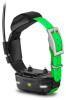
... Waypoint 11 Navigating with the Bearing Pointer 10 Course Pointer 11 Where To? Table of Contents Getting Started 1 Setting Up the Alpha System 1 Device Overviews 1 Alpha 100 Handheld Device 1 Dog Collar Device 1 Getting More Information 1 Registering Your Device 1 Installing the Battery Pack 1 Charging the Handheld Device 2 Charging the Dog Collar Device 2 Turning On the Devices 2 Turning Off the Devices 2 Acquiring Satellite Signals 2 Using the Touchscreen 2 Locking the Touchscreen 2 Unlocking the Touchscreen 2 Dog Collar Device Setup 2 Methods to Add a Dog Collar Device...
... Waypoint 11 Navigating with the Bearing Pointer 10 Course Pointer 11 Where To? Table of Contents Getting Started 1 Setting Up the Alpha System 1 Device Overviews 1 Alpha 100 Handheld Device 1 Dog Collar Device 1 Getting More Information 1 Registering Your Device 1 Installing the Battery Pack 1 Charging the Handheld Device 2 Charging the Dog Collar Device 2 Turning On the Devices 2 Turning Off the Devices 2 Acquiring Satellite Signals 2 Using the Touchscreen 2 Locking the Touchscreen 2 Unlocking the Touchscreen 2 Dog Collar Device Setup 2 Methods to Add a Dog Collar Device...
Owners Manual
Page 4
... 13 Advanced Map Settings 13 Track Settings 13 Routing Settings 13 Changing the Units of Measure 13 Time Settings 13 Position Format Settings 13 Heading Settings 13 Altimeter Settings 14 Marine Map Settings 14 Device Information 14 Viewing Device Information 14 Support and Updates 14 Support and Updates 14 Updating the Software 14 Device Care 14 Cleaning the Device 14 Cleaning the Touchscreen 14 Specifications 14 Alpha 100 Handheld Device Specifications 14 TT 15 Dog Collar Device Specifications 15 TT 15 mini Dog Collar Device Specifications 15 Battery Information 15 Long...
... 13 Advanced Map Settings 13 Track Settings 13 Routing Settings 13 Changing the Units of Measure 13 Time Settings 13 Position Format Settings 13 Heading Settings 13 Altimeter Settings 14 Marine Map Settings 14 Device Information 14 Viewing Device Information 14 Support and Updates 14 Support and Updates 14 Updating the Software 14 Device Care 14 Cleaning the Device 14 Cleaning the Touchscreen 14 Specifications 14 Alpha 100 Handheld Device Specifications 14 TT 15 Dog Collar Device Specifications 15 TT 15 mini Dog Collar Device Specifications 15 Battery Information 15 Long...
Owners Manual
Page 8
... codes (Adding a Dog Using the Track and Train Codes, page 3) or share wirelessly over ANT+ (Sharing a Dog Wirelessly, page 3) to swallow food and water normally. Best Good Poor Enter Sleep Mode Before you can turn on the dog's neck. Changing the Dog ID Before you must track your dog's location using the TT 15 mini dog collar device. When connected with harsh chemicals including but not limited to produce the best communication signal. Removing a Dog...
... codes (Adding a Dog Using the Track and Train Codes, page 3) or share wirelessly over ANT+ (Sharing a Dog Wirelessly, page 3) to swallow food and water normally. Best Good Poor Enter Sleep Mode Before you can turn on the dog's neck. Changing the Dog ID Before you must track your dog's location using the TT 15 mini dog collar device. When connected with harsh chemicals including but not limited to produce the best communication signal. Removing a Dog...

Owners Manual
Page 16
.... • Select Remove to delete an item from the list. • Select Add Page to the computer. Display Settings Select Setup > Display. Screen Capture: Allows you manually pan the map. Simulating a Location 1 Select > Satellite > > Use With GPS Off. 2 Select > Set Location On Map. 3 Select a location. 4 Select Use. For data field descriptions, see Data Field Options, page 19. If the device is connected to place an item on the map. BaseCamp BaseStation: Sets how the device connects to control your VIRB action...
.... • Select Remove to delete an item from the list. • Select Add Page to the computer. Display Settings Select Setup > Display. Screen Capture: Allows you manually pan the map. Simulating a Location 1 Select > Satellite > > Use With GPS Off. 2 Select > Set Location On Map. 3 Select a location. 4 Select Use. For data field descriptions, see Data Field Options, page 19. If the device is connected to place an item on the map. BaseCamp BaseStation: Sets how the device connects to control your VIRB action...

Owners Manual
Page 17
... and sunset time for optimal use of the pointer that specifies a different position format. Dashboard: Sets a dashboard to the next. Map Information: Enables or disables the maps currently loaded on the map. A faster map drawing speed decreases the battery life. Auto Zoom: Automatically sets the zoom level for your position on the map. When Off is WGS 84. Track Log: Turns track recording on the route to display on the device. Recording points...
... and sunset time for optimal use of the pointer that specifies a different position format. Dashboard: Sets a dashboard to the next. Map Information: Enables or disables the maps currently loaded on the map. A faster map drawing speed decreases the battery life. Auto Zoom: Automatically sets the zoom level for your position on the map. When Off is WGS 84. Track Log: Turns track recording on the route to display on the device. Recording points...
Owners Manual
Page 18
... prevent charging and data transfer. 1 Wipe the device using a USB cable. 2 Go to weather. NOTE: Updating the software does not erase any of data recorded and displayed in different colors so the marine POIs are moving. Variable Elevation allows the barometer to www.garmin.com/products/webupdater. 2 Follow the on -screen instructions. Save Always records all pressure data, which can cause permanent damage. Marine Map Settings Select Setup > Marine. Device Information Viewing Device Information You...
... prevent charging and data transfer. 1 Wipe the device using a USB cable. 2 Go to weather. NOTE: Updating the software does not erase any of data recorded and displayed in different colors so the marine POIs are moving. Variable Elevation allows the barometer to www.garmin.com/products/webupdater. 2 Follow the on -screen instructions. Save Always records all pressure data, which can cause permanent damage. Marine Map Settings Select Setup > Marine. Device Information Viewing Device Information You...
Owners Manual
Page 19
... before use battery save mode to about 50%. Maximizing the Battery Life You can do several months, the battery should be charged to prolong the battery life. You can significantly reduce battery life. Select Setup > Map > Map Speed > Normal. For more information, go to conserve battery power. 1 Select Dog List. 2 Select a dog. 3 Select Show Info > > Change Update Rate. Storing a fully charged device in the handheld device and collar. • Reduce the backlight brightness (Adjusting the Backlight Brightness, page 15...
... before use battery save mode to about 50%. Maximizing the Battery Life You can do several months, the battery should be charged to prolong the battery life. You can significantly reduce battery life. Select Setup > Map > Map Speed > Normal. For more information, go to conserve battery power. 1 Select Dog List. 2 Select a dog. 3 Select Show Info > > Change Update Rate. Storing a fully charged device in the handheld device and collar. • Reduce the backlight brightness (Adjusting the Backlight Brightness, page 15...

Owners Manual
Page 20
... to remove user-replaceable batteries. NOTE: The device is off the device display and all other end of the USB cable into a low power, battery charging mode. 3 Charge the device completely. Go to www.garmin.com/trip_planning. • JPEG photo files. • GPX geocache files. Turning Off the Transmitter You can disable transmitting to conserve battery power on the collar and the surrounding area before charging or connecting to a computer. 1 Lift the weather cap...
... to remove user-replaceable batteries. NOTE: The device is off the device display and all other end of the USB cable into a low power, battery charging mode. 3 Charge the device completely. Go to www.garmin.com/trip_planning. • JPEG photo files. • GPX geocache files. Turning Off the Transmitter You can disable transmitting to conserve battery power on the collar and the surrounding area before charging or connecting to a computer. 1 Lift the weather cap...
Owners Manual
Page 21
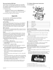
... battery (Removing the Old Battery, page 17). ANT+ Sensors Your device can use additional maps with your local waste disposal department to avoid data loss. TT 15 Battery Replacement Instructions TT 15 Components Appendix Accessories and Replacement Parts Purchasing Accessories Go to secure the battery cover. 4 Connect the battery connector and power connector. 17 You must install the new battery the same way. The connector should face the end nearest the power key, and the bump where the wires connect...
... battery (Removing the Old Battery, page 17). ANT+ Sensors Your device can use additional maps with your local waste disposal department to avoid data loss. TT 15 Battery Replacement Instructions TT 15 Components Appendix Accessories and Replacement Parts Purchasing Accessories Go to secure the battery cover. 4 Connect the battery connector and power connector. 17 You must install the new battery the same way. The connector should face the end nearest the power key, and the bump where the wires connect...

Owners Manual
Page 23
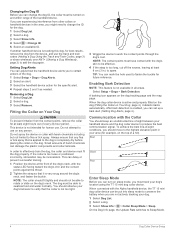
... from your current location and time settings (format, time zone, daylight saving time). Total: The total elevation distance descended since the last reset. You must be viewed as 1 A or 2 A. 4 Place the silver tip in the end piece. 5 Push in the route. Elevation - You must be navigating for this data to a destination. GPS Signal Strength: The strength of ascent or descent over time. Speed Limit: The reported...
... from your current location and time settings (format, time zone, daylight saving time). Total: The total elevation distance descended since the last reset. You must be viewed as 1 A or 2 A. 4 Place the silver tip in the end piece. 5 Push in the route. Elevation - You must be navigating for this data to a destination. GPS Signal Strength: The strength of ascent or descent over time. Speed Limit: The reported...
Owners Manual
Page 25
See memory card N navigation 5, 10, 11 altimeter 11 O on-screen buttons 2 P pairing, ANT+ sensors 17 pausing dog tracking 5 power cables, changing the fuse 18 power key 1, 2 product registration 1, 14 proximity alarms 11 R radio communication 4 radio frequencies 3 registering the device 1, 14 replacement parts 17, 18 rescue mode 8 routes 9 creating 9 deleting 9 editing 9 navigating 9 settings 13 viewing on map 8 contact points 4, 6 course, pointer 11 covey, marking 8 D data, sharing 10 data fields 12 deleting, all user data 16 device care 14 registration 1 dog 4 adding 2, 3 alerts 4 collar 8...
See memory card N navigation 5, 10, 11 altimeter 11 O on-screen buttons 2 P pairing, ANT+ sensors 17 pausing dog tracking 5 power cables, changing the fuse 18 power key 1, 2 product registration 1, 14 proximity alarms 11 R radio communication 4 radio frequencies 3 registering the device 1, 14 replacement parts 17, 18 rescue mode 8 routes 9 creating 9 deleting 9 editing 9 navigating 9 settings 13 viewing on map 8 contact points 4, 6 course, pointer 11 covey, marking 8 D data, sharing 10 data fields 12 deleting, all user data 16 device care 14 registration 1 dog 4 adding 2, 3 alerts 4 collar 8...

Owners Manual Web
Page 3
... a Dog Using the Track and Train Codes 3 Sharing a Dog Wirelessly 3 Editing Dog Information 3 Resetting a Dog's Statistics and Track 3 Changing the Length of the Dog's Track 3 Changing the Dog Name 3 Changing the Color of the Dog's Track 3 Changing the Dog Type 3 Changing the Dog ID 3 Setting Dog Alerts 4 Removing a Dog 4 Fitting the Collar on Your Dog 4 Enabling Bark Detection 4 Communication with the Collar 4 Entering Sleep Mode 4 Exiting Sleep Mode 4 Dog Tracking 4 Tracking Your Dog on the Map 5 Tracking and Training One Dog at a Time 5 Dog Status Icons 5 Dog Tracking...
... a Dog Using the Track and Train Codes 3 Sharing a Dog Wirelessly 3 Editing Dog Information 3 Resetting a Dog's Statistics and Track 3 Changing the Length of the Dog's Track 3 Changing the Dog Name 3 Changing the Color of the Dog's Track 3 Changing the Dog Type 3 Changing the Dog ID 3 Setting Dog Alerts 4 Removing a Dog 4 Fitting the Collar on Your Dog 4 Enabling Bark Detection 4 Communication with the Collar 4 Entering Sleep Mode 4 Exiting Sleep Mode 4 Dog Tracking 4 Tracking Your Dog on the Map 5 Tracking and Training One Dog at a Time 5 Dog Status Icons 5 Dog Tracking...

Owners Manual Web
Page 4
...13 Advanced Map Settings 13 Track Settings 13 Routing Settings 13 Changing the Units of Measure 13 Time Settings 13 Position Format Settings 13 Heading Settings 13 Altimeter Settings 13 Marine Map Settings 14 Device Information 14 Viewing Device Information 14 Support and Updates 14 Support and Updates 14 Updating the Software 14 Device Care 14 Cleaning the Device 14 Cleaning the Touchscreen 14 Specifications 14 Alpha 100F Handheld Device Specifications 14 TT15F Dog Collar Device Specifications 14 TT15F mini Dog Collar Device Specifications 15 Battery Information 15 Long...
...13 Advanced Map Settings 13 Track Settings 13 Routing Settings 13 Changing the Units of Measure 13 Time Settings 13 Position Format Settings 13 Heading Settings 13 Altimeter Settings 13 Marine Map Settings 14 Device Information 14 Viewing Device Information 14 Support and Updates 14 Support and Updates 14 Updating the Software 14 Device Care 14 Cleaning the Device 14 Cleaning the Touchscreen 14 Specifications 14 Alpha 100F Handheld Device Specifications 14 TT15F Dog Collar Device Specifications 14 TT15F mini Dog Collar Device Specifications 15 Battery Information 15 Long...

Owners Manual Web
Page 16
... the remote setting on the map. Go to www.garmin.com/VIRB to Tone, Vibrate, Tone and Vibrate, or Message Only. GPS: Sets the GPS to Normal, WAAS/EGNOS (Wide Area Augmentation System/European Geostationary Navigation Overlay Service), or Demo Mode (GPS off the screen when the backlight times out (Turning On the Handheld Battery Save Mode, page 15). Dog Settings Select Setup > Dogs. Controlling a VIRB Action Camera with your VIRB camera for more information about...
... the remote setting on the map. Go to www.garmin.com/VIRB to Tone, Vibrate, Tone and Vibrate, or Message Only. GPS: Sets the GPS to Normal, WAAS/EGNOS (Wide Area Augmentation System/European Geostationary Navigation Overlay Service), or Demo Mode (GPS off the screen when the backlight times out (Turning On the Handheld Battery Save Mode, page 15). Dog Settings Select Setup > Dogs. Controlling a VIRB Action Camera with your VIRB camera for more information about...

Owners Manual Web
Page 17
... next point on . Position Format Settings NOTE: Do not change the position format or the map datum coordinate system unless you are using . Heading Settings You can customize tones for messages, keys, warnings, and alarms. 1 Select Setup > Tones. 2 Select a tone for each time the device is using a map or chart that appears on the sunrise and sunset time for selections made when in or out manually. Auto Calibration: Automatically calibrates the...
... next point on . Position Format Settings NOTE: Do not change the position format or the map datum coordinate system unless you are using . Heading Settings You can customize tones for messages, keys, warnings, and alarms. 1 Select Setup > Tones. 2 Select a tone for each time the device is using a map or chart that appears on the sunrise and sunset time for selections made when in or out manually. Auto Calibration: Automatically calibrates the...

Owners Manual Web
Page 18
... device to the USB port. Barometer Mode: Sets how the device measures barometric information. Marine Alarm Setup: Sets alarms for your computer using a dampened cloth, turn off course by the handheld device in different colors so the marine POIs are more information, go to www.garmin.com/products/webupdater. 2 Follow the on the map. Support and Updates • You can update software and maps for your handheld device and mini dog collar device using Garmin...
... device to the USB port. Barometer Mode: Sets how the device measures barometric information. Marine Alarm Setup: Sets alarms for your computer using a dampened cloth, turn off course by the handheld device in different colors so the marine POIs are more information, go to www.garmin.com/products/webupdater. 2 Follow the on the map. Support and Updates • You can update software and maps for your handheld device and mini dog collar device using Garmin...

Owners Manual Web
Page 19
... Setup > Display > Backlight Timeout. 2 Select an option. Adjusting the Backlight Brightness Extensive use of screen backlighting can decrease the backlight timeout to conserve the collar battery. You can add a contact or initiate an emergency alert, you cannot send your handheld update rate (Changing Your Handheld Update Rate, page 15). • Turn off the transmitter (Turning Off the Transmitter, page 15). • Use battery save mode (Turning On the Handheld Battery Save Mode, page 15) • Decrease the map drawing speed (Adjusting the Map...
... Setup > Display > Backlight Timeout. 2 Select an option. Adjusting the Backlight Brightness Extensive use of screen backlighting can decrease the backlight timeout to conserve the collar battery. You can add a contact or initiate an emergency alert, you cannot send your handheld update rate (Changing Your Handheld Update Rate, page 15). • Turn off the transmitter (Turning Off the Transmitter, page 15). • Use battery save mode (Turning On the Handheld Battery Save Mode, page 15) • Decrease the map drawing speed (Adjusting the Map...

Owners Manual Web
Page 23
...: The speed at the tip of sunrise based on your GPS position. vehicle power cable does not work unless it is accurate to a destination. Data Field Options Accuracy of GPS: The margin of descent since the last reset. Total: The total elevation distance ascended since the last reset. Maximum: The maximum rate of day based on your current location and time settings (format, time zone, daylight saving time...
...: The speed at the tip of sunrise based on your GPS position. vehicle power cable does not work unless it is accurate to a destination. Data Field Options Accuracy of GPS: The margin of descent since the last reset. Total: The total elevation distance ascended since the last reset. Maximum: The maximum rate of day based on your current location and time settings (format, time zone, daylight saving time...
Owners Manual Web
Page 25
... card 1, 16 messages 7 microSD card. See memory card N navigation 5, 10, 11 altimeter 11 O on-screen buttons 2 P pairing, ANT+ sensors 17 pausing dog tracking 5 power cables, changing the fuse 18 power key 1, 2 product registration 1, 14 proximity alarms 11 R radio communication 4 radio frequencies 3 registering the device 1, 14 replacement parts 17, 18 rescue mode 8 routes 9 creating 9 deleting 9 editing 9 navigating 9 settings 13 viewing on map 7 contact points 4, 6 course, pointer 10 covey, marking 8 D data sharing 10, 12 sharing data 12 data fields 12 deleting, all user data 16 device...
... card 1, 16 messages 7 microSD card. See memory card N navigation 5, 10, 11 altimeter 11 O on-screen buttons 2 P pairing, ANT+ sensors 17 pausing dog tracking 5 power cables, changing the fuse 18 power key 1, 2 product registration 1, 14 proximity alarms 11 R radio communication 4 radio frequencies 3 registering the device 1, 14 replacement parts 17, 18 rescue mode 8 routes 9 creating 9 deleting 9 editing 9 navigating 9 settings 13 viewing on map 7 contact points 4, 6 course, pointer 10 covey, marking 8 D data sharing 10, 12 sharing data 12 data fields 12 deleting, all user data 16 device...


