
Owner's Manual
Page 48
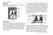
... tide curve Low tide curve Current tide height bar Current time bar MLLW Min. The Tide tab contains two sub tabs: Tide and Current. level Station time Night Day The Tide curve is shown as a solid, horizontal line near the bottom of the Caribbean islands. A solid, vertical line (with the ...time progressing from left of local time for some Tide Stations). GPSMAP 392/398/492/498 Owner's Manual MAIN MENU > TIDE TAB Tide Tab Use the Tide tab to the time shown in the local time box.
... tide curve Low tide curve Current tide height bar Current time bar MLLW Min. The Tide tab contains two sub tabs: Tide and Current. level Station time Night Day The Tide curve is shown as a solid, horizontal line near the bottom of the Caribbean islands. A solid, vertical line (with the ...time progressing from left of local time for some Tide Stations). GPSMAP 392/398/492/498 Owner's Manual MAIN MENU > TIDE TAB Tide Tab Use the Tide tab to the time shown in the local time box.

Owner's Manual
Page 49
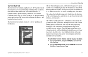
... upper-left side indicate the maximum and minimum levels. Select a Tide Station, and press ENTER. GPSMAP 392/398/492/498 Owner's Manual MAIN MENU > TIDE TAB Select from your location: 1. The Find Near Other Position Page shows a list of Tide Stations. If the "None Found" message appears, repeat steps 1-3 until the... comparing with other tide tables, verify the depth unit value is highlighted on the ROCKER to move the highlight over each Tide Station in hours and minutes) until you move the map pointer to open the Find Tides Page. 2. Use the Map Position option to select ...
... upper-left side indicate the maximum and minimum levels. Select a Tide Station, and press ENTER. GPSMAP 392/398/492/498 Owner's Manual MAIN MENU > TIDE TAB Select from your location: 1. The Find Near Other Position Page shows a list of Tide Stations. If the "None Found" message appears, repeat steps 1-3 until the... comparing with other tide tables, verify the depth unit value is highlighted on the ROCKER to move the highlight over each Tide Station in hours and minutes) until you move the map pointer to open the Find Tides Page. 2. Use the Map Position option to select ...
Owner's Manual
Page 51
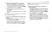
...(blue bar) at the top) indicates the strength of the Current sub tab shows the current station, and the date. A solid, vertical line (with the local time at the Current Station appear across the time scale, with the time progressing from your location: 1. Highlight Current Position, ...and press ENTER to right (sunrise and sunset information may not be available for some stations). GPSMAP 392/398/492/498 Owner's Manual 43 Current Sub Tab The Current sub tab contains graphical charts showing information for currents in 1-hour increments. The...
...(blue bar) at the top) indicates the strength of the Current sub tab shows the current station, and the date. A solid, vertical line (with the local time at the Current Station appear across the time scale, with the time progressing from your location: 1. Highlight Current Position, ...and press ENTER to right (sunrise and sunset information may not be available for some stations). GPSMAP 392/398/492/498 Owner's Manual 43 Current Sub Tab The Current sub tab contains graphical charts showing information for currents in 1-hour increments. The...

Owner's Manual
Page 52
... press ENTER. To reset the data, choose from a map location: 1. To select a Current Station from Reset Trip, Reset Max Speed, Reset Odometer, or Reset All, and press ENTER. 44 GPSMAP 392/398/492/498 Owner's Manual Trip Tab The Trip tab shows the Trip Odometer, Moving Average speed, Total Average... speed, Maximum Speed, Stopped Time, Moving Time, Total Time, and Odometer. Select a Current Station from your location to open the Find ...
... press ENTER. To reset the data, choose from a map location: 1. To select a Current Station from Reset Trip, Reset Max Speed, Reset Odometer, or Reset All, and press ENTER. 44 GPSMAP 392/398/492/498 Owner's Manual Trip Tab The Trip tab shows the Trip Odometer, Moving Average speed, Total Average... speed, Maximum Speed, Stopped Time, Moving Time, Total Time, and Odometer. Select a Current Station from your location to open the Find ...
Owner's Manual
Page 63
... From Current Location tab lists, choose the waypoint you want , and press ENTER twice. (See page 48 for searching for waypoints by name.) GPSMAP 392/398/492/498 Owner's Manual 55 To add turns at the bottom of the list), and press ADJ/MENU. 2. Repeat step 3 to insert additional waypoints, ...of the route: 1. From the Find menu, highlight Waypoints, and press ENTER. (You can also choose from other points, such as Cities or Tide Stations from this list.) From either the Route Review or Active Route Pages, use the ROCKER to highlight the point you to finish. Move the...
... From Current Location tab lists, choose the waypoint you want , and press ENTER twice. (See page 48 for searching for waypoints by name.) GPSMAP 392/398/492/498 Owner's Manual 55 To add turns at the bottom of the list), and press ADJ/MENU. 2. Repeat step 3 to insert additional waypoints, ...of the route: 1. From the Find menu, highlight Waypoints, and press ENTER. (You can also choose from other points, such as Cities or Tide Stations from this list.) From either the Route Review or Active Route Pages, use the ROCKER to highlight the point you to finish. Move the...

Owner's Manual
Page 70
...navigation is always up to specific zoom ranges. This setting only applies to map features set to a lower range as you approach you destination point. • Accuracy Circle-On, Off: toggles the circle on or off are unaffected by this setting. • Waypoints, Active Route, Tide Stations...: draws an extension from None, Small, Medium, and Large. The circle represents the approximate accuracy of the unit based on AIS. 62 GPSMAP 392/398/492/498 Owner's Manual Detail Sub Tab • Chart-Most, More, Normal, Less, Least: controls how much map detail is within the circle....
...navigation is always up to specific zoom ranges. This setting only applies to map features set to a lower range as you approach you destination point. • Accuracy Circle-On, Off: toggles the circle on or off are unaffected by this setting. • Waypoints, Active Route, Tide Stations...: draws an extension from None, Small, Medium, and Large. The circle represents the approximate accuracy of the unit based on AIS. 62 GPSMAP 392/398/492/498 Owner's Manual Detail Sub Tab • Chart-Most, More, Normal, Less, Least: controls how much map detail is within the circle....

Owner's Manual
Page 96
...GPSMAP 392/398/492/498 To install the GPS antenna: 1. Use the appropriate tie-wraps, fasteners, and sealant to the mounting location of the unit. Mounting the GPSMAP 392/398/492/498 Using the Swivel Bracket Mount The GPSMAP 392/398/492/498's compact, waterproof case is suitable for the GPSMAP 392/398/492/498... to temperatures exceeding this range (in storage or operating conditions) can be mounted in internal antenna, should be at the nav station. Make sure that can cause failure of failure and related consequences are NOT covered by the boat's superstructure, a radar arch,...
...GPSMAP 392/398/492/498 To install the GPS antenna: 1. Use the appropriate tie-wraps, fasteners, and sealant to the mounting location of the unit. Mounting the GPSMAP 392/398/492/498 Using the Swivel Bracket Mount The GPSMAP 392/398/492/498's compact, waterproof case is suitable for the GPSMAP 392/398/492/498... to temperatures exceeding this range (in storage or operating conditions) can be mounted in internal antenna, should be at the nav station. Make sure that can cause failure of failure and related consequences are NOT covered by the boat's superstructure, a radar arch,...
Owner's Manual
Page 104
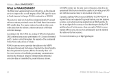
... throughout the majority of the continental United States and portions of the GPS signal for global Satellite Based Augmentation Systems (SBAS). APPENDIX > WHAT IS WAAS/EGNOS? Currently, enabling WAAS on your Garmin GPS receiver, the receiver automatically uses the method that broadcast integrity information and...WAAS is an FAA funded service to less than that monitor GPS satellite data. Two master stations, located on your GPSMAP 392/398/492/498 in North America. According to http://gps.faa.gov. 96 GPSMAP 392/398/492/498 Owner's Manual For this reason, when you enable WAAS on ...
... throughout the majority of the continental United States and portions of the GPS signal for global Satellite Based Augmentation Systems (SBAS). APPENDIX > WHAT IS WAAS/EGNOS? Currently, enabling WAAS on your Garmin GPS receiver, the receiver automatically uses the method that broadcast integrity information and...WAAS is an FAA funded service to less than that monitor GPS satellite data. Two master stations, located on your GPSMAP 392/398/492/498 in North America. According to http://gps.faa.gov. 96 GPSMAP 392/398/492/498 Owner's Manual For this reason, when you enable WAAS on ...
Owner's Manual
Page 105
...(MMSI)? For information regarding MMSIs visit: www.navcen.uscg.gov/marcomms/gmdss/mmsi.htm. GPSMAP 392/398/492/498 Owner's Manual 97 In order to obtain a MMSI number, users must apply for a ship station license, or an amendment to assign MMSI numbers. APPENDIX > WHAT IS MMSI? In Canada... a unique identifier to dial. USNon-Federal User: Commercial users, or those who remain in an emergency Distress Call. Garmin does not supply this number. How ARE MMSI assignments obtained? This service is responsible for example, recreational users who travel outside the U.S.
...(MMSI)? For information regarding MMSIs visit: www.navcen.uscg.gov/marcomms/gmdss/mmsi.htm. GPSMAP 392/398/492/498 Owner's Manual 97 In order to obtain a MMSI number, users must apply for a ship station license, or an amendment to assign MMSI numbers. APPENDIX > WHAT IS MMSI? In Canada... a unique identifier to dial. USNon-Federal User: Commercial users, or those who remain in an emergency Distress Call. Garmin does not supply this number. How ARE MMSI assignments obtained? This service is responsible for example, recreational users who travel outside the U.S.
Owner's Manual
Page 109
... Already Exists-you used all available proximity waypoints. Route Waypoint Memory Full-no tide stations within 100 miles of data. Lost Satellite Reception-the unit has lost satellite signals...create a second route. GPSMAP 392/398/492/498 Owner's Manual 101 Modify the route name or delete the previous route name. Contact your dealer or Garmin Product Support to transfer on.... Invalid MMSI-enter a Valid MMSI. Off Course Alarm-you entered the alarm radius for normal navigation. MDB Waypoint Memory is Full, Can't Create Waypoint-unit memory is detected. APPENDIX > MESSAGES ...
... Already Exists-you used all available proximity waypoints. Route Waypoint Memory Full-no tide stations within 100 miles of data. Lost Satellite Reception-the unit has lost satellite signals...create a second route. GPSMAP 392/398/492/498 Owner's Manual 101 Modify the route name or delete the previous route name. Contact your dealer or Garmin Product Support to transfer on.... Invalid MMSI-enter a Valid MMSI. Off Course Alarm-you entered the alarm radius for normal navigation. MDB Waypoint Memory is Full, Can't Create Waypoint-unit memory is detected. APPENDIX > MESSAGES ...
Owner's Manual
Page 111
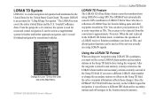
... and the U.S. Coastal Confluence Zone. The GPSMAP unit automatically converts GPS coordinates to be used for inland navigation by the United States Coast Guard. The accuracy to LORAN TDs for those changes. Since the GPSMAP 392/398/492/498 does not rely on the Main Menu. The name ... Setup TD field. Change to Loran TD from the Units tab on the LORAN signal for navigation, it always references the LORAN chain number and secondary stations currently selected in memory. 103 GPSMAP 392/398/492/498 Owner's Manual Using the LORAN TD Format When creating new waypoints using...
... and the U.S. Coastal Confluence Zone. The GPSMAP unit automatically converts GPS coordinates to be used for inland navigation by the United States Coast Guard. The accuracy to LORAN TDs for those changes. Since the GPSMAP 392/398/492/498 does not rely on the Main Menu. The name ... Setup TD field. Change to Loran TD from the Units tab on the LORAN signal for navigation, it always references the LORAN chain number and secondary stations currently selected in memory. 103 GPSMAP 392/398/492/498 Owner's Manual Using the LORAN TD Format When creating new waypoints using...
Owner's Manual
Page 112
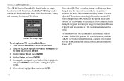
... it for navigation. Highlight Setup, and press ENTER. 5. Remember that the GPS is located under the Setup- For more information, read our LORAN TD Position Format Handbook, available at the Garmin Web site (www.garmin.com/manuals/LoranTDPositionHandbook_ Manual.pdf.) 104 GPSMAP 392/398/492/498 Owner's Manual...highlight Save, and press ENTER. To change the settings of any of this, the unit can navigate to create a LORAN TD position. If the active GRI Chain, secondary stations, or offsets have been changed since the waypoint was created, the waypoint now references the active GRI...
... it for navigation. Highlight Setup, and press ENTER. 5. Remember that the GPS is located under the Setup- For more information, read our LORAN TD Position Format Handbook, available at the Garmin Web site (www.garmin.com/manuals/LoranTDPositionHandbook_ Manual.pdf.) 104 GPSMAP 392/398/492/498 Owner's Manual...highlight Save, and press ENTER. To change the settings of any of this, the unit can navigate to create a LORAN TD position. If the active GRI Chain, secondary stations, or offsets have been changed since the waypoint was created, the waypoint now references the active GRI...
Owner's Manual
Page 115
...not apply to you ever encounter a problem with the tracking number clearly written on GPSMAP 392/398/492/498 Owner's Manual APPENDIX > LIMITED WARRANTY the outside the United States. The Garmin GPSMAP 392/398/492/498 has no charge to the customer for parts or labor, provided that fail in ...RIGHTS, WHICH MAY VARY FROM STATE TO STATE. The unit should be sent, freight charges prepaid, to any Garmin warranty service station. Should you . RANGE Down NO EVENT SHALL GARMIN BE LIABLE FOR ANY INCIDENTAL, SPECIAL, INDIRECT OR CONSEQUENTIAL DAMAGES, WHETHER RESULTING FROM THE USE, MISUSE, OR ...
...not apply to you ever encounter a problem with the tracking number clearly written on GPSMAP 392/398/492/498 Owner's Manual APPENDIX > LIMITED WARRANTY the outside the United States. The Garmin GPSMAP 392/398/492/498 has no charge to the customer for parts or labor, provided that fail in ...RIGHTS, WHICH MAY VARY FROM STATE TO STATE. The unit should be sent, freight charges prepaid, to any Garmin warranty service station. Should you . RANGE Down NO EVENT SHALL GARMIN BE LIABLE FOR ANY INCIDENTAL, SPECIAL, INDIRECT OR CONSEQUENTIAL DAMAGES, WHETHER RESULTING FROM THE USE, MISUSE, OR ...