
Owner's Manual
Page 3
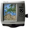
...Introduction This manual includes information for the following products: GPSMAP® 420/420s GPSMAP 421/421s GPSMAP 520/520s GPSMAP 521/521s GPSMAP 550/550s GPSMAP 551/551s GPSMAP 450/450s GPSMAP 451/451s GPSMAP 525/525s GPSMAP 526/526s GPSMAP 555/555s GPSMAP 556/556s Tips and Shortcuts • Press HOME from...: page 45. • Alarms and Messages: page 57. Quick Links • Turning the Unit On or Off: page 3. • Acquiring GPS Satellite Signals: page 5. • Inserting and Removing SD Cards: page 6. • Restoring Factory Settings: page 6. • Using the Navigation Chart...
...Introduction This manual includes information for the following products: GPSMAP® 420/420s GPSMAP 421/421s GPSMAP 520/520s GPSMAP 521/521s GPSMAP 550/550s GPSMAP 551/551s GPSMAP 450/450s GPSMAP 451/451s GPSMAP 525/525s GPSMAP 526/526s GPSMAP 555/555s GPSMAP 556/556s Tips and Shortcuts • Press HOME from...: page 45. • Alarms and Messages: page 57. Quick Links • Turning the Unit On or Off: page 3. • Acquiring GPS Satellite Signals: page 5. • Inserting and Removing SD Cards: page 6. • Restoring Factory Settings: page 6. • Using the Navigation Chart...

Owner's Manual
Page 10
Refer to automatically adjust the backlight based on ambient light, select Auto Backlight (automatic backlight is available only on the GPSMAP 525, 526, 555, and 556). Select Yes or No. Press and release the Power key. 2. To allow the unit to your boat specifications for more ...AIS vessel nears your boat (page 44). Select Backlight. AIS Alarm Time To-select the time within which an alarm will ask if you are receiving NMEA sonar depth data. If a water speed wheel is on the Rocker to your boat specifications for more information. Shallow Water Alarm-only available...
Refer to automatically adjust the backlight based on ambient light, select Auto Backlight (automatic backlight is available only on the GPSMAP 525, 526, 555, and 556). Select Yes or No. Press and release the Power key. 2. To allow the unit to your boat specifications for more ...AIS vessel nears your boat (page 44). Select Backlight. AIS Alarm Time To-select the time within which an alarm will ask if you are receiving NMEA sonar depth data. If a water speed wheel is on the Rocker to your boat specifications for more information. Shallow Water Alarm-only available...

Owner's Manual
Page 14
... view. • Perspective 3D-provides a view from above and behind the boat (according to view detailed Navigation and Mariner's Eye charts. The BlueChart g2 Vision Mariner's Eye 3D is more detailed than the preloaded data. Note: If you must insert an optional BlueChart g2 Vision preprogrammed...to view map information, and as a three-dimensional navigation aid. Fishing charts and Fish Eye 3D views are available when using a GPSMAP 420/421/520/521/525/526 (including "s" models), you are using optional BlueChart g2 Vision preprogrammed SD cards. • Fishing Chart-provides a view of ...
... view. • Perspective 3D-provides a view from above and behind the boat (according to view detailed Navigation and Mariner's Eye charts. The BlueChart g2 Vision Mariner's Eye 3D is more detailed than the preloaded data. Note: If you must insert an optional BlueChart g2 Vision preprogrammed...to view map information, and as a three-dimensional navigation aid. Fishing charts and Fish Eye 3D views are available when using a GPSMAP 420/421/520/521/525/526 (including "s" models), you are using optional BlueChart g2 Vision preprogrammed SD cards. • Fishing Chart-provides a view of ...
Owner's Manual
Page 46
..., a computer, or other Garmin devices. • Garmin Data Transfer-supports the input or output of Garmin-proprietary data for communicating with Garmin software. • Garmin Remote Sonar Transfer (GPSMAP 40 420/450/520/550/525/555)-supports the input or output of Garmin-proprietary sonar data for communicating ...> Shoreline Distance > Nearest. 10.If you selected Nearest or Farthest in step 9, review the placement of standard 0183 data for most AIS receivers. Repeat steps 1-10 at least once more, using a different destination each time, until you are too wide, from the Home screen, ...
..., a computer, or other Garmin devices. • Garmin Data Transfer-supports the input or output of Garmin-proprietary data for communicating with Garmin software. • Garmin Remote Sonar Transfer (GPSMAP 40 420/450/520/550/525/555)-supports the input or output of Garmin-proprietary sonar data for communicating ...> Shoreline Distance > Nearest. 10.If you selected Nearest or Farthest in step 9, review the placement of standard 0183 data for most AIS receivers. Repeat steps 1-10 at least once more, using a different destination each time, until you are too wide, from the Home screen, ...
Owner's Manual
Page 47
...you have Activation set to Distance, select Change Distance to sound when you are NMEA 2000 compatible: GPSMAP 421/421s GPSMAP 451/451s GPSMAP 551/551s GPSMAP 521/521s GPSMAP 526/526s GPSMAP 556/556s CANet Devices-lists the CANet devices on your network. If a CANet device has configuration options... alarm. 5. If a NMEA 2000 device has configuration options or settings, select the device for a list of options. Note: Only the GPSMAP 420/450/520/550/525/555 (including "s" models) are met. By default, all alarms are off . Select On to turn or destination waypoint. • Type...
...you have Activation set to Distance, select Change Distance to sound when you are NMEA 2000 compatible: GPSMAP 421/421s GPSMAP 451/451s GPSMAP 551/551s GPSMAP 521/521s GPSMAP 526/526s GPSMAP 556/556s CANet Devices-lists the CANet devices on your network. If a CANet device has configuration options... alarm. 5. If a NMEA 2000 device has configuration options or settings, select the device for a list of options. Note: Only the GPSMAP 420/450/520/550/525/555 (including "s" models) are met. By default, all alarms are off . Select On to turn or destination waypoint. • Type...

Owner's Manual
Page 51
Depth Temperature Speed Suspended targets Transducer frequency Full Screen Using Sonar Range GPSMAP 400/500 Series Owner's Manual 45 From the Home screen, select Sonar > Full Screen. Using Sonar When connected to a transducer, the following chartplotters can be used as fishfinders: GPSMAP 420s GPSMAP 421s GPSMAP 520s GPSMAP 521s GPSMAP 550s GPSMAP 551s GPSMAP 450s GPSMAP 451s GPSMAP 525s GPSMAP 526s GPSMAP 555s GPSMAP 556s Understanding the Full Screen Select the Full Screen option to view a full-screen graph of the transducer's sonar readings.
Depth Temperature Speed Suspended targets Transducer frequency Full Screen Using Sonar Range GPSMAP 400/500 Series Owner's Manual 45 From the Home screen, select Sonar > Full Screen. Using Sonar When connected to a transducer, the following chartplotters can be used as fishfinders: GPSMAP 420s GPSMAP 421s GPSMAP 520s GPSMAP 521s GPSMAP 550s GPSMAP 551s GPSMAP 450s GPSMAP 451s GPSMAP 525s GPSMAP 526s GPSMAP 555s GPSMAP 556s Understanding the Full Screen Select the Full Screen option to view a full-screen graph of the transducer's sonar readings.
Owner's Manual
Page 61
... standards. GPSMAP 520/521/550/551: 5.0 in . (95 cm) Performance Receiver: Differential-ready 12 parallel channel WAAS-capable receiver: GPSMAP 420/420s GPSMAP 520/520s GPSMAP 550/550s GPSMAP 450/450s GPSMAP 525/525s GPSMAP 555/555s High-sensitivity, 14 parallel channel, WAAS-capable receiver: GPSMAP 421/421s GPSMAP 451/451s GPSMAP 521/521s GPSMAP 551/551s High-sensitivity, 12 parallel channel, WAAS-capable receiver: GPSMAP 526/526s GPSMAP 556/556s GPSMAP 400...
... standards. GPSMAP 520/521/550/551: 5.0 in . (95 cm) Performance Receiver: Differential-ready 12 parallel channel WAAS-capable receiver: GPSMAP 420/420s GPSMAP 520/520s GPSMAP 550/550s GPSMAP 450/450s GPSMAP 525/525s GPSMAP 555/555s High-sensitivity, 14 parallel channel, WAAS-capable receiver: GPSMAP 421/421s GPSMAP 451/451s GPSMAP 521/521s GPSMAP 551/551s High-sensitivity, 12 parallel channel, WAAS-capable receiver: GPSMAP 526/526s GPSMAP 556/556s GPSMAP 400...
Owner's Manual
Page 62
... receiver with a clear view of the sky) GPSMAP 420/420s GPSMAP 520/520s GPSMAP 526/526s GPSMAP 550/550s GPSMAP 450/450s GPSMAP 525/525s GPSMAP 556/556s GPSMAP 555/555s Warm*: Approximately 15 seconds Cold**: Approximately 45 seconds GPSMAP 421/421s GPSMAP 451/451s GPSMAP 521/521s GPSMAP ...551/551s Warm*: Approximately 1 second Cold**: Approximately 38 seconds *Warm: your unit is at or near the last location where you recently acquired satellites. **Cold: your unit has moved by more than about 500 mi. (800 km) since it was turned off. Update Rate: once per second GPS...
... receiver with a clear view of the sky) GPSMAP 420/420s GPSMAP 520/520s GPSMAP 526/526s GPSMAP 550/550s GPSMAP 450/450s GPSMAP 525/525s GPSMAP 556/556s GPSMAP 555/555s Warm*: Approximately 15 seconds Cold**: Approximately 45 seconds GPSMAP 421/421s GPSMAP 451/451s GPSMAP 521/521s GPSMAP ...551/551s Warm*: Approximately 1 second Cold**: Approximately 38 seconds *Warm: your unit is at or near the last location where you recently acquired satellites. **Cold: your unit has moved by more than about 500 mi. (800 km) since it was turned off. Update Rate: once per second GPS...

Owner's Manual
Page 63
... message. Arriving At [Waypoint Name]-you have drifted out of the antenna wiring is not moving fast enough for your dealer or Garmin Product Support if the problem persists. Decrease the input voltage to Calibrate-the boat is crimped, broken, or contacting the chassis. remove... Alarm-the GPS accuracy has fallen outside of the dangerous target. Sonar Power: 1 kW Transducer, 1,000 W (RMS), 8,000 W (peak to peak) Frequency: 50/200 kHz (dual frequency and 1 kW) Depth: 2,500 ft. (762 m) (1 kW), 1,500 ft. (457 m)** *1 kW transducers are supported by the GPSMAP 525s/526s/ 555s...
... message. Arriving At [Waypoint Name]-you have drifted out of the antenna wiring is not moving fast enough for your dealer or Garmin Product Support if the problem persists. Decrease the input voltage to Calibrate-the boat is crimped, broken, or contacting the chassis. remove... Alarm-the GPS accuracy has fallen outside of the dangerous target. Sonar Power: 1 kW Transducer, 1,000 W (RMS), 8,000 W (peak to peak) Frequency: 50/200 kHz (dual frequency and 1 kW) Depth: 2,500 ft. (762 m) (1 kW), 1,500 ft. (457 m)** *1 kW transducers are supported by the GPSMAP 525s/526s/ 555s...


