Owner's Manual
Page 18
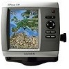
... than one item is only available while using a BlueChart g2 Vision SD card. Use the map pointer ( ) to a compatible marine wind sensor. 12 GPSMAP 400/500 Series Owner's Manual High-resolution satellite imagery is in -depth graph for a tide station to view information about tides, ...change chart settings from the home screen, select Charts > Navigation Chart > MENU > Chart Setup. You can view an in the area, select Review, and then select the item. To access additional object information: 1. On the Navigation chart, highlight an item with a detailed icon showing the...
... than one item is only available while using a BlueChart g2 Vision SD card. Use the map pointer ( ) to a compatible marine wind sensor. 12 GPSMAP 400/500 Series Owner's Manual High-resolution satellite imagery is in -depth graph for a tide station to view information about tides, ...change chart settings from the home screen, select Charts > Navigation Chart > MENU > Chart Setup. You can view an in the area, select Review, and then select the item. To access additional object information: 1. On the Navigation chart, highlight an item with a detailed icon showing the...
Owner's Manual
Page 26
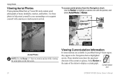
These detailed icons show the speed and direction of the station to acquaint yourself with the pointer, and select Aerial Photo or Review. Select Review or the name of the current at a glance. Perspective Overhead Aerial Photo Note: Use the Range (-/+) keys to zoom in your... surroundings or to display a current graph. Current-station icon 20 GPSMAP 400/500 Series Owner's Manual To access aerial photos from the Navigation chart: Use ...
These detailed icons show the speed and direction of the station to acquaint yourself with the pointer, and select Aerial Photo or Review. Select Review or the name of the current at a glance. Perspective Overhead Aerial Photo Note: Use the Range (-/+) keys to zoom in your... surroundings or to display a current graph. Current-station icon 20 GPSMAP 400/500 Series Owner's Manual To access aerial photos from the Navigation chart: Use ...

Owner's Manual
Page 30
...you want to change (Name, Symbol, Depth, Water Temp, Comment, or Position). Select the waypoint attribute you want to edit. 3. Select Review. (The Review button is only shown when more than one waypoint is in the vicinity.) 3. Select the button for each waypoint. To mark your present ...the waypoint on the Navigation chart. 2. To view a list of all waypoints: From the Home screen, select Information > User Data > Waypoints. 24 GPSMAP 400/500 Series Owner's Manual To create a new waypoint: 1. Where To? Creating and Using Waypoints You can store up to 1,500 waypoints (3,000...
...you want to change (Name, Symbol, Depth, Water Temp, Comment, or Position). Select the waypoint attribute you want to edit. 3. Select Review. (The Review button is only shown when more than one waypoint is in the vicinity.) 3. Select the button for each waypoint. To mark your present ...the waypoint on the Navigation chart. 2. To view a list of all waypoints: From the Home screen, select Information > User Data > Waypoints. 24 GPSMAP 400/500 Series Owner's Manual To create a new waypoint: 1. Where To? Creating and Using Waypoints You can store up to 1,500 waypoints (3,000...

Owner's Manual
Page 31
... present location: 1. From the Home screen, select Information > User Data > Routes > New Route. 2. Select Use Chart or Use Waypoint List. 3. GPSMAP 400/500 Series Owner's Manual 25 From the Navigation chart, use the map pointer ( ) to select the initial location at which you select Use Chart...pointer ( ) to undo the last turn and press SELECT. If you want to make the last turn toward your destination. 4. Select Review > Delete (The Review button is only shown when more than one waypoint is complete. Use the map pointer ( ) to select the location at which you want...
... present location: 1. From the Home screen, select Information > User Data > Routes > New Route. 2. Select Use Chart or Use Waypoint List. 3. GPSMAP 400/500 Series Owner's Manual 25 From the Navigation chart, use the map pointer ( ) to select the initial location at which you select Use Chart...pointer ( ) to undo the last turn and press SELECT. If you want to make the last turn toward your destination. 4. Select Review > Delete (The Review button is only shown when more than one waypoint is complete. Use the map pointer ( ) to select the location at which you want...
Owner's Manual
Page 45
...Distance-set the minimum height (chart height datum) of a bridge that your boat can assess the placement of the Auto Guidance line. GPSMAP 400/500 Series Owner's Manual 39 • Safe Height-set the safe distance for your boat or drop anchor. 2. Shoreline Distance...from the Home screen, select Configure > Preferences > Navigation > Auto Guidance > Shoreline Distance > Far. • If the turns in step 7, review the placement of the auto-guidance line using one or more familiar destinations that require navigation through a narrow waterway. Select a waypoint for the Shoreline ...
...Distance-set the minimum height (chart height datum) of a bridge that your boat can assess the placement of the Auto Guidance line. GPSMAP 400/500 Series Owner's Manual 39 • Safe Height-set the safe distance for your boat or drop anchor. 2. Shoreline Distance...from the Home screen, select Configure > Preferences > Navigation > Auto Guidance > Shoreline Distance > Far. • If the turns in step 7, review the placement of the auto-guidance line using one or more familiar destinations that require navigation through a narrow waterway. Select a waypoint for the Shoreline ...
Owner's Manual
Page 46
...a computer, or other Garmin devices. • Garmin Data Transfer-supports the input or output of Garmin-proprietary data for communicating with Garmin software. • Garmin Remote Sonar Transfer (GPSMAP 40 420/450/520/550/525/555)-supports the input or output of Garmin-proprietary sonar data for ...Serial Port 2 (if supported)-configures the input/output format for most AIS receivers. Select a setting (Sounder, Route, System, or Garmin). 3. Configuring the Chartplotter • If the turns in step 9, review the placement of the Auto Guidance line. Serial Port 1-configures the input/...
...a computer, or other Garmin devices. • Garmin Data Transfer-supports the input or output of Garmin-proprietary data for communicating with Garmin software. • Garmin Remote Sonar Transfer (GPSMAP 40 420/450/520/550/525/555)-supports the input or output of Garmin-proprietary sonar data for ...Serial Port 2 (if supported)-configures the input/output format for most AIS receivers. Select a setting (Sounder, Route, System, or Garmin). 3. Configuring the Chartplotter • If the turns in step 9, review the placement of the Auto Guidance line. Serial Port 1-configures the input/...
Owner's Manual
Page 57
...; Select Call with the distress call, that information is received from the chartplotter. If position information was sent. Select Review to call . 1. Select Create Waypoint to set up ...to 100 entries. If a second call is also available and recorded with the radio to view details about the call list. Complete one of the most -recent call . GPSMAP... or NMEA 2000, your chartplotter alerts you when your Garmin chartplotter and VHF radio are using a Garmin NMEA 2000compatible VHF radio. • Select Edit to toggle...
...; Select Call with the distress call, that information is received from the chartplotter. If position information was sent. Select Review to call . 1. Select Create Waypoint to set up ...to 100 entries. If a second call is also available and recorded with the radio to view details about the call list. Complete one of the most -recent call . GPSMAP... or NMEA 2000, your chartplotter alerts you when your Garmin chartplotter and VHF radio are using a Garmin NMEA 2000compatible VHF radio. • Select Edit to toggle...
Owner's Manual
Page 60
To make an individual routine call: 1. On your Garmin chartplotter to a Garmin VHF NMEA 2000-compatible radio, you connect your Garmin VHF radio, select Call. 54 GPSMAP 400/500 Series Owner's Manual Digital Selective Calling To make an individual routine call to an AIS target: 1. Select Send ... radio, select Call. While viewing a chart, use the chartplotter interface to set up an individual routine call to an AIS target. Select Review > Call with Radio. 3. Select Send to send the information about the call to the radio. 5. While viewing a chart, press MENU > Other Vessels > ...
To make an individual routine call: 1. On your Garmin chartplotter to a Garmin VHF NMEA 2000-compatible radio, you connect your Garmin VHF radio, select Call. 54 GPSMAP 400/500 Series Owner's Manual Digital Selective Calling To make an individual routine call to an AIS target: 1. Select Send ... radio, select Call. While viewing a chart, use the chartplotter interface to set up an individual routine call to an AIS target. Select Review > Call with Radio. 3. Select Send to send the information about the call to the radio. 5. While viewing a chart, press MENU > Other Vessels > ...

Quick Reference Guide
Page 1
... Use the Rocker to view the 50 nearest destinations that contain your destination. 3. Select Review. (The Review button is only shown when more than one waypoint is in the vicinity.) GPSMAP® 400/500 series quick reference guide Select Edit Waypoint. 4. Select a destination. 4....Create a Waypoint Editing or Deleting a Waypoint To edit an existing waypoint: 1. Select Review > Delete (The Review button is only shown when more than one waypoint is in the vicinity.) 3. Finding a Marine Service and Navigating to change (Name, Symbol, Depth, Water Temp, Comment, or ...
... Use the Rocker to view the 50 nearest destinations that contain your destination. 3. Select Review. (The Review button is only shown when more than one waypoint is in the vicinity.) GPSMAP® 400/500 series quick reference guide Select Edit Waypoint. 4. Select a destination. 4....Create a Waypoint Editing or Deleting a Waypoint To edit an existing waypoint: 1. Select Review > Delete (The Review button is only shown when more than one waypoint is in the vicinity.) 3. Finding a Marine Service and Navigating to change (Name, Symbol, Depth, Water Temp, Comment, or ...