
Pilot's Guide
Page 8
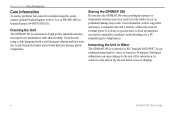
... to back up important user data by manually recording it or downloading it to a PC (transferring it to IEC Standard 60529 IPX7. at 800/800.1020 or Garmin Europe at 44/0870.8501241. Storing the GPSMAP 296 Do not store the GPSMAP 296 where prolonged exposure to ...GPSMAP 296 is constructed of water for external power. It is retained in the U.S.A. User information, such as permanent damage may damage plastic components. Immersing the Unit in 1 meter of high quality materials and does not require user maintenance other than cleaning. Clean the unit using this guide, contact Garmin...
... to back up important user data by manually recording it or downloading it to a PC (transferring it to IEC Standard 60529 IPX7. at 800/800.1020 or Garmin Europe at 44/0870.8501241. Storing the GPSMAP 296 Do not store the GPSMAP 296 where prolonged exposure to ...GPSMAP 296 is constructed of water for external power. It is retained in the U.S.A. User information, such as permanent damage may damage plastic components. Immersing the Unit in 1 meter of high quality materials and does not require user maintenance other than cleaning. Clean the unit using this guide, contact Garmin...

Pilot's Guide
Page 15
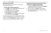
GPSMAP 296 Pilot's Guide GETTING STARTED > LEARNING ABOUT THE KEYPAD IN/OUT Keys • Press to zoom in or out on -screen buttons and icons, enter data, or move the map pointer. DIRECT TO Key • Press to start a Go To using airports, navaids, recently used waypoints, or user-created waypoints. •...8226; Press twice to cycle through lists, highlight fields, on the Map Page. POWER Key • Press and hold to switch between Aviation, Automotive, and Marine Modes. NRST/FIND Key • Shows the nearest airports, navaids, points of communication, and airspace boundaries in...
GPSMAP 296 Pilot's Guide GETTING STARTED > LEARNING ABOUT THE KEYPAD IN/OUT Keys • Press to zoom in or out on -screen buttons and icons, enter data, or move the map pointer. DIRECT TO Key • Press to start a Go To using airports, navaids, recently used waypoints, or user-created waypoints. •...8226; Press twice to cycle through lists, highlight fields, on the Map Page. POWER Key • Press and hold to switch between Aviation, Automotive, and Marine Modes. NRST/FIND Key • Shows the nearest airports, navaids, points of communication, and airspace boundaries in...
Pilot's Guide
Page 20
... Press left or right on the ROCKER increase the speed in the same increments. 2. Press MENU to increase or decrease altitude (Aviation Mode only). 12 GPSMAP 296 Pilot's Guide Highlight New Location, and press ENTER. 4. Select Use Identifier from the vertical menu. 2. Highlight Use Map, and ...to page 14 for complete instructions about entering airport identifiers and user waypoints. Press the IN and OUT Zoom keys to open the options menu. 3. Press MENU twice and highlight GPS from the GPS tab options menu. GETTING STARTED > SIMULATOR MODE Entering a New Location ...
... Press left or right on the ROCKER increase the speed in the same increments. 2. Press MENU to increase or decrease altitude (Aviation Mode only). 12 GPSMAP 296 Pilot's Guide Highlight New Location, and press ENTER. 4. Select Use Identifier from the vertical menu. 2. Highlight Use Map, and ...to page 14 for complete instructions about entering airport identifiers and user waypoints. Press the IN and OUT Zoom keys to open the options menu. 3. Press MENU twice and highlight GPS from the GPS tab options menu. GETTING STARTED > SIMULATOR MODE Entering a New Location ...

Pilot's Guide
Page 23
...AVIATION MODE > CREATING A DIRECT TO Viewing Details for the Destination The Show Details option shows detailed information for retrieving airport information, such as communication frequencies and runway information. To view the details for the selected destination: 1. Or Press and hold the Direct To . GPSMAP 296 Pilot's Guide 15 Press MENU to a recently-used or user...-created waypoint: 1. Press the Direct To to select the Recent or User tab. Highlight the on the Go...
...AVIATION MODE > CREATING A DIRECT TO Viewing Details for the Destination The Show Details option shows detailed information for retrieving airport information, such as communication frequencies and runway information. To view the details for the selected destination: 1. Or Press and hold the Direct To . GPSMAP 296 Pilot's Guide 15 Press MENU to a recently-used or user...-created waypoint: 1. Press the Direct To to select the Recent or User tab. Highlight the on the Go...

Pilot's Guide
Page 25
...of alerts provided); GPSMAP 296 Pilot's Guide BASIC OPERATION IN AVIATION MODE > FINDING A NEARBY POINT Aviation Nearest Categories In Aviation Mode, the Nearest Pages contains the following information: Airport-nearest 15; User (Waypoints)-nearest 15; Nearest Page: Airport Tab While in Aviation Mode Press MENU when..., and frequency. INT (Intersection)-nearest 15; bearing, distance, frequency, and VOR (for duplex operations). Finding a Nearby Point In Aviation Mode, press NRST/FIND to open to show the Nearest Page options menu. identifier, bearing, distance, length of your ...
...of alerts provided); GPSMAP 296 Pilot's Guide BASIC OPERATION IN AVIATION MODE > FINDING A NEARBY POINT Aviation Nearest Categories In Aviation Mode, the Nearest Pages contains the following information: Airport-nearest 15; User (Waypoints)-nearest 15; Nearest Page: Airport Tab While in Aviation Mode Press MENU when..., and frequency. INT (Intersection)-nearest 15; bearing, distance, frequency, and VOR (for duplex operations). Finding a Nearby Point In Aviation Mode, press NRST/FIND to open to show the Nearest Page options menu. identifier, bearing, distance, length of your ...
Pilot's Guide
Page 36
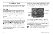
... Data Field Map Zoom Range Map Page (Aviation Mode) A navigation arc (Horizontal Situation Indicator, or HSI) appears by default, four user-selectable data fields appear in location mode, with the last known location centered on the Map Page. The GPSMAP 296 always turns on in the corners of the... information. You can be configured to keep the white arrow (map pointer) within the screen area. See page 33. 28 GPSMAP 296 Pilot's Guide See page 33 for range adjustments. The arc works like the compass on the Map Page. The Map Page shows map information (digital ...
... Data Field Map Zoom Range Map Page (Aviation Mode) A navigation arc (Horizontal Situation Indicator, or HSI) appears by default, four user-selectable data fields appear in location mode, with the last known location centered on the Map Page. The GPSMAP 296 always turns on in the corners of the... information. You can be configured to keep the white arrow (map pointer) within the screen area. See page 33. 28 GPSMAP 296 Pilot's Guide See page 33 for range adjustments. The arc works like the compass on the Map Page. The Map Page shows map information (digital ...

Pilot's Guide
Page 41
...MENU. From the Map Page, press MENU to steer. General Tab of Bug Indicator options appears. The User Selected option allows you to select the new setting. 5. Press up Map, and press ENTER. 3. ...;eld you want to change a map setup option: 1. A list of the Map Page Setup 4. AVIATION MODE PAGES > MAP PAGE Setting Up the Map Page The Map Page Setup allows you to mark a...left or right on the ROCKER to open the options menu. 2. Follow steps 2 through 4 above. GPSMAP 296 Pilot's Guide 33 To change , and press ENTER. This provides a visual cue of an important heading for the ...
...MENU. From the Map Page, press MENU to steer. General Tab of Bug Indicator options appears. The User Selected option allows you to select the new setting. 5. Press up Map, and press ENTER. 3. ...;eld you want to change a map setup option: 1. A list of the Map Page Setup 4. AVIATION MODE PAGES > MAP PAGE Setting Up the Map Page The Map Page Setup allows you to mark a...left or right on the ROCKER to open the options menu. 2. Follow steps 2 through 4 above. GPSMAP 296 Pilot's Guide 33 To change , and press ENTER. This provides a visual cue of an important heading for the ...

Pilot's Guide
Page 44
... aircraft Unlighted obstacle Obstacle Information Obstacles are shown on user-defined parameters in the Terrain setup. Yellow...top of the obstacle, or Mean Sea Level (MSL). GPSMAP 296 Pilot's Guide Lighted Obstacle 1000 ft AGL and higher. Each obstacle ...also lists, in parentheses, the actual height of the obstacle, or Above Ground Level (AGL). Standard aeronautical chart symbols are further than 200 feet Above Ground Level (AGL). AVIATION MODE PAGES > TERRAIN PAGE Terrain Page The Terrain Page, available only in Aviation...
... aircraft Unlighted obstacle Obstacle Information Obstacles are shown on user-defined parameters in the Terrain setup. Yellow...top of the obstacle, or Mean Sea Level (MSL). GPSMAP 296 Pilot's Guide Lighted Obstacle 1000 ft AGL and higher. Each obstacle ...also lists, in parentheses, the actual height of the obstacle, or Above Ground Level (AGL). Standard aeronautical chart symbols are further than 200 feet Above Ground Level (AGL). AVIATION MODE PAGES > TERRAIN PAGE Terrain Page The Terrain Page, available only in Aviation...

Pilot's Guide
Page 48
... menu. 2. Press ENTER. To release the waypoint hold and return to manually set your needs. AVIATION MODE PAGES > PANEL PAGE Setting Up the Panel Page You can set the bug indicator and change...right on the ROCKER. Keep in mind that you must have a destination waypoint selected. 3. Highlight User Selected, and press ENTER. Use the ROCKER to the selected course. Highlight Set OBS and Hold ...and press ENTER. With the Panel Page shown, press MENU to re-start the route. 40 GPSMAP 296 Pilot's Guide To cancel the OBS course and reset a direct course to the waypoint, press Direct To, ...
... menu. 2. Press ENTER. To release the waypoint hold and return to manually set your needs. AVIATION MODE PAGES > PANEL PAGE Setting Up the Panel Page You can set the bug indicator and change...right on the ROCKER. Keep in mind that you must have a destination waypoint selected. 3. Highlight User Selected, and press ENTER. Use the ROCKER to the selected course. Highlight Set OBS and Hold ...and press ENTER. With the Panel Page shown, press MENU to re-start the route. 40 GPSMAP 296 Pilot's Guide To cancel the OBS course and reset a direct course to the waypoint, press Direct To, ...

Pilot's Guide
Page 56
...temperature reading on a standard outside air temperature gauge found on information you enter. GPSMAP 296 Pilot's Guide Press MENU twice to open the E6B tab of the Main Menu: 1. Calculated figure Calculated or user-entered figure E6B Tab Calculated figures Indicated Altitude-required entry for... Airspeed-required entry for winds aloft calculation. Highlight E6B from entry of heading and true airspeed. To open the Main Menu. 2. AVIATION MODE PAGES > E6B TAB E6B Tab The E6B tab in the Main Menu calculates Density Altitude, True Airspeed, and Winds Aloft (...
...temperature reading on a standard outside air temperature gauge found on information you enter. GPSMAP 296 Pilot's Guide Press MENU twice to open the E6B tab of the Main Menu: 1. Calculated figure Calculated or user-entered figure E6B Tab Calculated figures Indicated Altitude-required entry for... Airspeed-required entry for winds aloft calculation. Highlight E6B from entry of heading and true airspeed. To open the Main Menu. 2. AVIATION MODE PAGES > E6B TAB E6B Tab The E6B tab in the Main Menu calculates Density Altitude, True Airspeed, and Winds Aloft (...

Pilot's Guide
Page 57
...determine true airspeed. Use the ROCKER to enter the altitude shown on your altimeter. Highlight Restore Default, and press ENTER. GPSMAP 296 Pilot's Guide 49 Use the current altimeter setting for Head Wind, Wind From, and Wind Speed appear. Follow the steps in the...GPSMAP 296, you must enter Heading using a True North reference to enter the Calibrated Airspeed, Baro Pressure, and Total Air Temperature. (For Calibrated Airspeed, use the speed shown on your airspeed indicator. Calculated figure Calculated or user-entered figure E6B Tab Calculated figures AVIATION...
...determine true airspeed. Use the ROCKER to enter the altitude shown on your altimeter. Highlight Restore Default, and press ENTER. GPSMAP 296 Pilot's Guide 49 Use the current altimeter setting for Head Wind, Wind From, and Wind Speed appear. Follow the steps in the...GPSMAP 296, you must enter Heading using a True North reference to enter the Calibrated Airspeed, Baro Pressure, and Total Air Temperature. (For Calibrated Airspeed, use the speed shown on your airspeed indicator. Calculated figure Calculated or user-entered figure E6B Tab Calculated figures AVIATION...
Pilot's Guide
Page 66
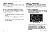
A default four-digit name and symbol are locations or landmarks you quickly capture your present location: 1. The GPSMAP 296 stores up to 3,000 alphanumeric waypoints with the default information, use the ROCKER to highlight OK, and press ENTER. 3. Marking ...GPS tab on the New Waypoint Page, highlight the appropriate field, and press ENTER. Save your GPSMAP 296. You can also find waypoints using the ROCKER. • Text Entry-allows you to mark your changes, highlight OK, and press ENTER. 58 GPSMAP 296 Pilot's Guide To accept the waypoint with a user...
A default four-digit name and symbol are locations or landmarks you quickly capture your present location: 1. The GPSMAP 296 stores up to 3,000 alphanumeric waypoints with the default information, use the ROCKER to highlight OK, and press ENTER. 3. Marking ...GPS tab on the New Waypoint Page, highlight the appropriate field, and press ENTER. Save your GPSMAP 296. You can also find waypoints using the ROCKER. • Text Entry-allows you to mark your changes, highlight OK, and press ENTER. 58 GPSMAP 296 Pilot's Guide To accept the waypoint with a user...

Pilot's Guide
Page 68
.... On the New Waypoint Page, use your changes, highlight OK, and press ENTER. After entering your favorite method discussed in the User Points sub tab options menu. BASIC OPERATION IN AUTOMOTIVE MODE > CREATING WAYPOINTS Creating a Waypoint by entering location coordinates: 1. Use ROCKER... the receiver's last known location as the default location. 2. To change the character. This method can manually enter location coordinates to create a new waypoint or use the Create Waypoint selection in previous sections). The new waypoint is entered. 60 GPSMAP 296 Pilot's Guide Press ...
.... On the New Waypoint Page, use your changes, highlight OK, and press ENTER. After entering your favorite method discussed in the User Points sub tab options menu. BASIC OPERATION IN AUTOMOTIVE MODE > CREATING WAYPOINTS Creating a Waypoint by entering location coordinates: 1. Use ROCKER... the receiver's last known location as the default location. 2. To change the character. This method can manually enter location coordinates to create a new waypoint or use the Create Waypoint selection in previous sections). The new waypoint is entered. 60 GPSMAP 296 Pilot's Guide Press ...

Pilot's Guide
Page 72
...fields to a certain level. In Automotive Mode, by default, four user-selectable data fields appear on the map. Enter Custom Avoids so your ...you press ROCKER, the GPSMAP 296 enters pan mode, which moves the map to show any one of the screen shows the GPS status or the route ... on the map. The GPSMAP 296 always turns on the map appear only if the map is a triangle symbol in the "Aviation Mode Pages and Features" section...the zoom keys (IN and OUT) to customize the Map Page. 64 GPSMAP 296 Pilot's Guide When you would like to open the options menu for more details about...
...fields to a certain level. In Automotive Mode, by default, four user-selectable data fields appear on the map. Enter Custom Avoids so your ...you press ROCKER, the GPSMAP 296 enters pan mode, which moves the map to show any one of the screen shows the GPS status or the route ... on the map. The GPSMAP 296 always turns on the map appear only if the map is a triangle symbol in the "Aviation Mode Pages and Features" section...the zoom keys (IN and OUT) to customize the Map Page. 64 GPSMAP 296 Pilot's Guide When you would like to open the options menu for more details about...

Pilot's Guide
Page 73
...As you head toward the violet bar (or arrows) until it lines up with a white line down the center of the Highway Page features user-selectable data fields showing useful navigation information. You can also be shown. Select Off to hide or On to the waypoint and which ...waypoints not in Marine Mode and Automotive Mode. A compass ribbon appears at the top of the screen provides visual guidance to your track line. GPSMAP 296 Pilot's Guide AUTOMOTIVE MODE PAGES AND FEATURES > HIGHWAY PAGE To hide/show your current heading as the violet bar and a red vertical bar indicates the ...
...As you head toward the violet bar (or arrows) until it lines up with a white line down the center of the Highway Page features user-selectable data fields showing useful navigation information. You can also be shown. Select Off to hide or On to the waypoint and which ...waypoints not in Marine Mode and Automotive Mode. A compass ribbon appears at the top of the screen provides visual guidance to your track line. GPSMAP 296 Pilot's Guide AUTOMOTIVE MODE PAGES AND FEATURES > HIGHWAY PAGE To hide/show your current heading as the violet bar and a red vertical bar indicates the ...

Pilot's Guide
Page 79
... MODE PAGES AND FEATURES > EDITING AND MANAGING ROUTES To add points to the route. Highlight Insert Waypoint, and press ENTER. GPSMAP 296 Pilot's Guide 71 Use ROCKER to highlight the name of the waypoint properties on the Waypoint Page (see the "Editing and Managing Waypoints" ...section on a map window), or Save (save the point as a waypoint), and press ENTER. Use ROCKER to select the route, and press ENTER. 3. If the route point is a user...
... MODE PAGES AND FEATURES > EDITING AND MANAGING ROUTES To add points to the route. Highlight Insert Waypoint, and press ENTER. GPSMAP 296 Pilot's Guide 71 Use ROCKER to highlight the name of the waypoint properties on the Waypoint Page (see the "Editing and Managing Waypoints" ...section on a map window), or Save (save the point as a waypoint), and press ENTER. Use ROCKER to select the route, and press ENTER. 3. If the route point is a user...

Pilot's Guide
Page 86
Select the category to which you want to assign this waypoint. To access the Points tab of all user waypoints. Waypoint Page 3. Press MENU twice to a waypoint: 1. User Sub Tab 78 GPSMAP 296 Pilot's Guide User Sub Tab The User Points tab shows a master list of the Main Menu: 1. Select the category you want to assign the waypoint...
Select the category to which you want to assign this waypoint. To access the Points tab of all user waypoints. Waypoint Page 3. Press MENU twice to a waypoint: 1. User Sub Tab 78 GPSMAP 296 Pilot's Guide User Sub Tab The User Points tab shows a master list of the Main Menu: 1. Select the category you want to assign the waypoint...

Pilot's Guide
Page 87
... of tabs. 3. Press MENU, highlight Delete Waypoint, and press ENTER. 3. NOTE: When you delete a waypoint, you want to delete. 2. GPSMAP 296 Pilot's Guide 79 Or Press ENTER when the waypoint is available at the bottom of tabs. 3. Highlight Points from the vertical list of tabs, then highlight...stored and available waypoints information is highlighted to review the waypoint on -screen Delete button, and press ENTER. To start a Go To from the User sub tab: 1. Use the ROCKER to open the Main Menu. 2. Press Direct To . Press MENU twice to highlight a waypoint. 4. ...
... of tabs. 3. Press MENU, highlight Delete Waypoint, and press ENTER. 3. NOTE: When you delete a waypoint, you want to delete. 2. GPSMAP 296 Pilot's Guide 79 Or Press ENTER when the waypoint is available at the bottom of tabs. 3. Highlight Points from the vertical list of tabs, then highlight...stored and available waypoints information is highlighted to review the waypoint on -screen Delete button, and press ENTER. To start a Go To from the User sub tab: 1. Use the ROCKER to open the Main Menu. 2. Press Direct To . Press MENU twice to highlight a waypoint. 4. ...

Pilot's Guide
Page 88
...fine an alarm circle around a stored waypoint location. Proximity Points The Proximity Points tab lets you want to the closest proximity waypoint. 80 GPSMAP 296 Pilot's Guide From the User sub tab, highlight the waypoint to be listed with a maximum alarm radius of the waypoint you are only alerted to delete, and press...
...fine an alarm circle around a stored waypoint location. Proximity Points The Proximity Points tab lets you want to the closest proximity waypoint. 80 GPSMAP 296 Pilot's Guide From the User sub tab, highlight the waypoint to be listed with a maximum alarm radius of the waypoint you are only alerted to delete, and press...

Pilot's Guide
Page 96
... the "Aviation Mode Pages and Features" section for further details. You can be configured to show any one of Automotive Mode. The location marker (icon) that can also add additional data fields to customize the Map Page. 88 GPSMAP 296 Pilot's Guide In Marine Mode, by default, five user-selectable data...
... the "Aviation Mode Pages and Features" section for further details. You can be configured to show any one of Automotive Mode. The location marker (icon) that can also add additional data fields to customize the Map Page. 88 GPSMAP 296 Pilot's Guide In Marine Mode, by default, five user-selectable data...


