
Pilot's Guide
Page 18
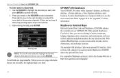
... products, refer to the previous character. You also should update your GPSMAP 296. Press right to move to the next character or press left to move back to the Garmin Web site at http://www.garmin.com/cartography/ 10 GPSMAP 296 Pilot's Guide Press up or down on a page with... a serial connector) is used to transfer MapSource CD-ROM data to use the most character field and press left -most current data. After entering the data, press ENTER. MapSource Detailed Maps Optional Garmin...
... products, refer to the previous character. You also should update your GPSMAP 296. Press right to move to the next character or press left to move back to the Garmin Web site at http://www.garmin.com/cartography/ 10 GPSMAP 296 Pilot's Guide Press up or down on a page with... a serial connector) is used to transfer MapSource CD-ROM data to use the most character field and press left -most current data. After entering the data, press ENTER. MapSource Detailed Maps Optional Garmin...

Pilot's Guide
Page 35
.... Alerts As you travel, a variety of your flight plans (routes) in a saved route, the route is an obsolete Jeppesen aviation point in your unit are still current. When a Terrain or Obstacle alert pops up , press NRST to your present location. Your route is ...constantly updated to view the Airspace Information. The airplane should be on page 39. For complete information about the Map Page and the features of the page to open the Terrain Page. GPSMAP 296 Pilot's Guide 27 View the HSI on the proper...
.... Alerts As you travel, a variety of your flight plans (routes) in a saved route, the route is an obsolete Jeppesen aviation point in your unit are still current. When a Terrain or Obstacle alert pops up , press NRST to your present location. Your route is ...constantly updated to view the Airspace Information. The airplane should be on page 39. For complete information about the Map Page and the features of the page to open the Terrain Page. GPSMAP 296 Pilot's Guide 27 View the HSI on the proper...
Pilot's Guide
Page 38
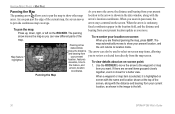
... field, and the distance and bearing from your present location update as shown in the data window, along with the distance and bearing from your current location, as you move. Map feature highlighted shows the distance and bearing from your present The arrow ...right, or left . 30 GPSMAP 296 Pilot's Guide location, feature's elevation, time to To view details about an on -screen: map. When you are several items grouped closely together, zoom in pan mode, the to provide continuous map coverage. AVIATION MODE PAGES > MAP PAGE Panning the Map As you move the arrow...
... field, and the distance and bearing from your present location update as shown in the data window, along with the distance and bearing from your current location, as you move. Map feature highlighted shows the distance and bearing from your present The arrow ...right, or left . 30 GPSMAP 296 Pilot's Guide location, feature's elevation, time to To view details about an on -screen: map. When you are several items grouped closely together, zoom in pan mode, the to provide continuous map coverage. AVIATION MODE PAGES > MAP PAGE Panning the Map As you move the arrow...

Pilot's Guide
Page 51
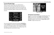
...a new route with the sequence of waypoints for information), Add Waypoint, and Invert. GPSMAP 296 Pilot's Guide 43 You can also select an approach for your landing and set your fuel..., Distance, and several other fields of information. AVIATION MODE PAGES > ACTIVE ROUTE PAGE Active Route Page Options Press MENU while on existing GPS, RNAV, VOR, NDB, localizer, or ILS approach procedures... in Aviation or Marine Mode, the Active Route Page shows each point (waypoint or map item) of the active route, with a Jeppesen point that is no longer current after you perform an update to ...
...a new route with the sequence of waypoints for information), Add Waypoint, and Invert. GPSMAP 296 Pilot's Guide 43 You can also select an approach for your landing and set your fuel..., Distance, and several other fields of information. AVIATION MODE PAGES > ACTIVE ROUTE PAGE Active Route Page Options Press MENU while on existing GPS, RNAV, VOR, NDB, localizer, or ILS approach procedures... in Aviation or Marine Mode, the Active Route Page shows each point (waypoint or map item) of the active route, with a Jeppesen point that is no longer current after you perform an update to ...
Pilot's Guide
Page 54
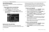
... select a saved aircraft profile: 1. AVIATION MODE PAGES > AIRCRAFT INFORMATION Aircraft Information The Aircraft tab is automatically updated if you to select the aircraft profile, and press ENTER. 46 GPSMAP 296 Pilot's Guide Press MENU twice to highlight the on the Panel Page and the map symbol. The maximum speed is used...
... select a saved aircraft profile: 1. AVIATION MODE PAGES > AIRCRAFT INFORMATION Aircraft Information The Aircraft tab is automatically updated if you to select the aircraft profile, and press ENTER. 46 GPSMAP 296 Pilot's Guide Press MENU twice to highlight the on the Panel Page and the map symbol. The maximum speed is used...
Pilot's Guide
Page 75
... Route Page Whenever you navigate a route, the turn list automatically updates to indicate the next turn at the top of arrival. As you have started a route in the GPSMAP 296 in a different layout. Highlight any of the turns on a map. Press MENU to the turn . Highlight OK and press ENTER to... view the Next Turn Page for that turn , the street name, and estimated time enroute and time of the list. GPSMAP 296 Pilot's Guide 67 ...
... Route Page Whenever you navigate a route, the turn list automatically updates to indicate the next turn at the top of arrival. As you have started a route in the GPSMAP 296 in a different layout. Highlight any of the turns on a map. Press MENU to the turn . Highlight OK and press ENTER to... view the Next Turn Page for that turn , the street name, and estimated time enroute and time of the list. GPSMAP 296 Pilot's Guide 67 ...
Pilot's Guide
Page 97
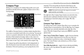
...over ground (track) while you are moving for the compass to open , press MENU to accurately update and show additional information during active navigation. NOTE: You must be moving . Like the Map Page, the Compass Page features user-selectable data fields on the right side of the "...and how to your preferences. Compass Page Options The options menu on the Compass Page allows you to customize the Compass Page to the GPSMAP 296 Pilot's Guide MARINE MODE PAGES AND FEATURES > COMPASS PAGE waypoint. Show Course Pointer/Show Compass-toggles between showing and hiding the course ...
...over ground (track) while you are moving for the compass to open , press MENU to accurately update and show additional information during active navigation. NOTE: You must be moving . Like the Map Page, the Compass Page features user-selectable data fields on the right side of the "...and how to your preferences. Compass Page Options The options menu on the Compass Page allows you to customize the Compass Page to the GPSMAP 296 Pilot's Guide MARINE MODE PAGES AND FEATURES > COMPASS PAGE waypoint. Show Course Pointer/Show Compass-toggles between showing and hiding the course ...

Pilot's Guide
Page 113
.... Press and hold IN or OUT to view information for another location using the map), or Near Destination. To use the Zoom IN and OUT keys to scroll quickly through dates. 3. GPSMAP 296 Pilot's Guide 105 The list is updated with the ROCKER, and press ENTER. The Tide tab appears again showing the tide...
.... Press and hold IN or OUT to view information for another location using the map), or Near Destination. To use the Zoom IN and OUT keys to scroll quickly through dates. 3. GPSMAP 296 Pilot's Guide 105 The list is updated with the ROCKER, and press ENTER. The Tide tab appears again showing the tide...
Pilot's Guide
Page 132
... sonar items and mark underwater waypoints. This makes it easier to mark. To return to update while the screen pauses, but the unit does not show any new sonar data until the... then press ENTER. 4. When using the ROCKER until the Sonar Page resumes scrolling. The New Map Waypoint Page appears. 3. SETTING UP AND USING SONAR > USING THE SONAR PAGE Noise Reject-helps...Sonar Page split screen, press MENU. 2. or press MENU, highlight Hide Pointer, and press ENTER. 124 GPSMAP 296 Pilot's Guide Using the ROCKER, highlight Size Split, and press ENTER. 3. When setting the Noise Reject...
... sonar items and mark underwater waypoints. This makes it easier to mark. To return to update while the screen pauses, but the unit does not show any new sonar data until the... then press ENTER. 4. When using the ROCKER until the Sonar Page resumes scrolling. The New Map Waypoint Page appears. 3. SETTING UP AND USING SONAR > USING THE SONAR PAGE Noise Reject-helps...Sonar Page split screen, press MENU. 2. or press MENU, highlight Hide Pointer, and press ENTER. 124 GPSMAP 296 Pilot's Guide Using the ROCKER, highlight Size Split, and press ENTER. 3. When setting the Noise Reject...
Pilot's Guide
Page 133
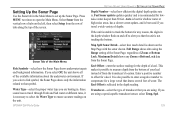
.... Water Type-select the proper water type you are boating in the depth reading. GPSMAP 296 Pilot's Guide SETTING UP AND USING SONAR > SETTING UP THE SONAR PAGE Depth Number-select how efficient the digital depth update rate is recommended for shallow water or high-noise areas, has a slower screen... the unit. If you are using a speed-capable transducer/sensor, select Temp, Spd. 125 Auto is best for lownoise water deeper than 50 feet. Map Split Sonar Detail-select how much detail is shown on the left, then select Setup from the vertical row of Zoom or Bottom Lock. If...
.... Water Type-select the proper water type you are boating in the depth reading. GPSMAP 296 Pilot's Guide SETTING UP AND USING SONAR > SETTING UP THE SONAR PAGE Depth Number-select how efficient the digital depth update rate is recommended for shallow water or high-noise areas, has a slower screen... the unit. If you are using a speed-capable transducer/sensor, select Temp, Spd. 125 Auto is best for lownoise water deeper than 50 feet. Map Split Sonar Detail-select how much detail is shown on the left, then select Setup from the vertical row of Zoom or Bottom Lock. If...
Pilot's Guide
Page 163
...26, 146 Updates 10 K Keypad 7 L Land at Closest Point 18 Language 110 Legs, Track 85 Limited Warranty 152 Lithium-ion 1, 2 Local Time 113 Location 6, 60 Location Format 114, 143 Locked Route 26 Log Filter 107 Longitude 149 LORAN TD Setup 141-142 Lost Satellite Reception 5 GPSMAP 296 Pilot's ...Guide M Magnetic Variation 115 Main Menu Display Tab 108 GPS tab 4 Sound Tab 109 Managing Routes 69 Managing Tracks 82 Managing Waypoints 73 Man OverBoard 87 Map Information 35, 55 MapSource 10, 137 Map Data 35 Map Datum 143 Map Orientation 29 Map Page Automotive Mode 64 Aviation Mode...
...26, 146 Updates 10 K Keypad 7 L Land at Closest Point 18 Language 110 Legs, Track 85 Limited Warranty 152 Lithium-ion 1, 2 Local Time 113 Location 6, 60 Location Format 114, 143 Locked Route 26 Log Filter 107 Longitude 149 LORAN TD Setup 141-142 Lost Satellite Reception 5 GPSMAP 296 Pilot's ...Guide M Magnetic Variation 115 Main Menu Display Tab 108 GPS tab 4 Sound Tab 109 Managing Routes 69 Managing Tracks 82 Managing Waypoints 73 Man OverBoard 87 Map Information 35, 55 MapSource 10, 137 Map Data 35 Map Datum 143 Map Orientation 29 Map Page Automotive Mode 64 Aviation Mode...
Pilot's Guide
Page 168
Unit 5, The Quadrangle, Abbey Park Industrial Estate, Romsey, SO51 9DL, U.K. Garmin (Europe) Ltd. or its subsidiaries Garmin International, Inc. 1200 East 151st Street, Olathe, Kansas 66062, U.S.A. D Garmin Corporation No. 68, Jangshu 2nd Road, Shijr, Taipei County, Taiwan www.garmin.com Part Number 190-00337-00 Rev. For the latest free software updates (excluding map data) throughout the life of your Garmin products, visit the Garmin Web site at www.garmin.com. © Copyright 2005 Garmin Ltd.
Unit 5, The Quadrangle, Abbey Park Industrial Estate, Romsey, SO51 9DL, U.K. Garmin (Europe) Ltd. or its subsidiaries Garmin International, Inc. 1200 East 151st Street, Olathe, Kansas 66062, U.S.A. D Garmin Corporation No. 68, Jangshu 2nd Road, Shijr, Taipei County, Taiwan www.garmin.com Part Number 190-00337-00 Rev. For the latest free software updates (excluding map data) throughout the life of your Garmin products, visit the Garmin Web site at www.garmin.com. © Copyright 2005 Garmin Ltd.


