GPS 12, 12XL, 48, 80 Addendum
Page 1
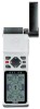
... ENTER. 3. The unit used to conserve battery power. Select 'SYSTEM SETUP' and press ENTER 3. Addendum GPS12,12XL, 48, 80 Calculate Track Area Power Save Mode 1 From the Map Page, highlight the 'OPT' selection at the top of the Power Save feature should not negatively affect operation under normal ... the CALC AREA feature you desire and press ENTER. Calculate Area The GPS can be determined automatically by the GPS or manually set by the user. This will cause the unit to display the SETUP MENU. 2. The GPS will falsify the readings. Power Save A new feature 'Power Save' ...
... ENTER. 3. The unit used to conserve battery power. Select 'SYSTEM SETUP' and press ENTER 3. Addendum GPS12,12XL, 48, 80 Calculate Track Area Power Save Mode 1 From the Map Page, highlight the 'OPT' selection at the top of the Power Save feature should not negatively affect operation under normal ... the CALC AREA feature you desire and press ENTER. Calculate Area The GPS can be determined automatically by the GPS or manually set by the user. This will cause the unit to display the SETUP MENU. 2. The GPS will falsify the readings. Power Save A new feature 'Power Save' ...

Owner's Manual
Page 3
...with multiple listings, such as map datums, time offsets, and the index. i To get the most from your outdoor gear. We hope the GPS 48 will meet all of your navigation needs and know it will become a valuable part of your new GPS, take the time to read...-friendly flexible design you'll enjoy for outdoor use! The GPS 48 represents GARMIN's continuing commitment to see that your GARMIN GPS 48 package includes the following items. If you are missing any parts, please contact your dealer immediately. Standard Package: • GPS 48 Unit • Owner's Manual • Wrist Strap •...
...with multiple listings, such as map datums, time offsets, and the index. i To get the most from your outdoor gear. We hope the GPS 48 will meet all of your navigation needs and know it will become a valuable part of your new GPS, take the time to read...-friendly flexible design you'll enjoy for outdoor use! The GPS 48 represents GARMIN's continuing commitment to see that your GARMIN GPS 48 package includes the following items. If you are missing any parts, please contact your dealer immediately. Standard Package: • GPS 48 Unit • Owner's Manual • Wrist Strap •...
Owner's Manual
Page 4
... AID (NAVAID), any interference received, including interference that interference will not occur in actual use . Although the GPS 48 is encouraged to try to all necessary FCC standards. This equipment generates, uses, and can be misused or ...sources including the information from other equipment, which could void your warranty and your own risk. The GPS 48 does not contain any discrepancies before continuing navigation. Unauthorized repairs or modifications could affect the accuracy and... connecting the equipment to other NAVAIDs, visual sightings, maps, etc.
... AID (NAVAID), any interference received, including interference that interference will not occur in actual use . Although the GPS 48 is encouraged to try to all necessary FCC standards. This equipment generates, uses, and can be misused or ...sources including the information from other equipment, which could void your warranty and your own risk. The GPS 48 does not contain any discrepancies before continuing navigation. Unauthorized repairs or modifications could affect the accuracy and... connecting the equipment to other NAVAIDs, visual sightings, maps, etc.
Owner's Manual
Page 5
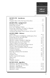
...Page 14-15 Battery Level Indicator, Backlighting, and Emergency Erase 16 Position Page & User Selectable Fields 17-18 Map Page & Marine Database 19-21 Map Page, Zooming, Panning & Configuring 22-23 Map Page, Track Log, City, & Navaid Setup 24-27 Using the Highway & Compass Pages 28-31 Marking... & Man Overboard 38 TrackBack Navigation 39-40 Creating & Using Routes 41-45 Menu Page & Distance/Sun Calculation 46 System Setup 46-48 Navigation Setup 49-51 Interface Setup & DGPS Interface 52-53 Alarms Setup 54 Find City 55 Navigation Simulator 56 SECTION FOUR Appendices Appendix ...
...Page 14-15 Battery Level Indicator, Backlighting, and Emergency Erase 16 Position Page & User Selectable Fields 17-18 Map Page & Marine Database 19-21 Map Page, Zooming, Panning & Configuring 22-23 Map Page, Track Log, City, & Navaid Setup 24-27 Using the Highway & Compass Pages 28-31 Marking... & Man Overboard 38 TrackBack Navigation 39-40 Creating & Using Routes 41-45 Menu Page & Distance/Sun Calculation 46 System Setup 46-48 Navigation Setup 49-51 Interface Setup & DGPS Interface 52-53 Alarms Setup 54 Find City 55 Navigation Simulator 56 SECTION FOUR Appendices Appendix ...
Owner's Manual
Page 13
...locations and nautical navaids on pages 21-22. The bottom of the page contains a compass ring and arrow to show you the way to the GPS 48's waypoint management, route, track log, and setup features through a list of the screen contains the zoom, pan, and configuration fields. appear ...along the path you are moving map. The center of the page gives your current track and speed. called a track log - Navigation Page A navigation page gives you access to the...
...locations and nautical navaids on pages 21-22. The bottom of the page contains a compass ring and arrow to show you the way to the GPS 48's waypoint management, route, track log, and setup features through a list of the screen contains the zoom, pan, and configuration fields. appear ...along the path you are moving map. The center of the page gives your current track and speed. called a track log - Navigation Page A navigation page gives you access to the...
Owner's Manual
Page 14
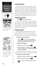
...measure, selectable fields, etc.) have been changed , the pictures and descriptions you see on the map. Turning the GPS 48 On 1. Once testing is really about using your GPS 48. If your screen. Marking a Position GPS is complete, the Satellite Page will skip the Satellite Page. To rename the waypoint: 1. ...500 waypoints.) To mark your unit has been turned on . If these settings have to mark a position as a waypoint. (Your GPS 48 can use our GPS 48 to guide us somewhere, we have been changed . The welcome page will become highlighted. Press the UP arrow to move backward. ...
...measure, selectable fields, etc.) have been changed , the pictures and descriptions you see on the map. Turning the GPS 48 On 1. Once testing is really about using your GPS 48. If your screen. Marking a Position GPS is complete, the Satellite Page will skip the Satellite Page. To rename the waypoint: 1. ...500 waypoints.) To mark your unit has been turned on . If these settings have to mark a position as a waypoint. (Your GPS 48 can use our GPS 48 to guide us somewhere, we have been changed . The welcome page will become highlighted. Press the UP arrow to move backward. ...
Owner's Manual
Page 15
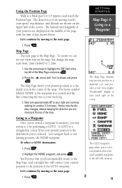
...latitude and longitude of your speed, trip distance, and altitude are moving to a Waypoint Once you've stored a waypoint in the center of the map . To ensure we can see our entire trip on the screen. Let's continue by moving (track), your position are moving to our starting position,...on the map, lets change the map scale from a list of all available waypoints in the middle of the page, with the time of the screen. Highlight the 'HOME' waypoint, and press E. Press the U arrow until '1nm' is your present position to the destination you are displayed in the GPS 48's memory...
...latitude and longitude of your speed, trip distance, and altitude are moving to a Waypoint Once you've stored a waypoint in the center of the map . To ensure we can see our entire trip on the screen. Let's continue by moving (track), your position are moving to our starting position,...on the map, lets change the map scale from a list of all available waypoints in the middle of the page, with the time of the screen. Highlight the 'HOME' waypoint, and press E. Press the U arrow until '1nm' is your present position to the destination you are displayed in the GPS 48's memory...

Owner's Manual
Page 17
...probably know a little more advanced features, turn the GPS 48 off . GETTING STARTED Clearing the Map, Contrast, & Power Off Highlight the 'CLEAR LOG?' Clearing a Cluttered Map Display After you've used the GPS 48 for a few trips, you may find that your map display has become a bit messy from the Satellite Page...key for nighttime use. Press Lor Rto adjust the level of the GPS 48's more than you to clear the track log. option and press E. prompt and press ENTER to experiment with the GPS 48 until the Map Page appears. 2. Pressing the LEFT or RIGHT arrows from the ...
...probably know a little more advanced features, turn the GPS 48 off . GETTING STARTED Clearing the Map, Contrast, & Power Off Highlight the 'CLEAR LOG?' Clearing a Cluttered Map Display After you've used the GPS 48 for a few trips, you may find that your map display has become a bit messy from the Satellite Page...key for nighttime use. Press Lor Rto adjust the level of the GPS 48's more than you to clear the track log. option and press E. prompt and press ENTER to experiment with the GPS 48 until the Map Page appears. 2. Pressing the LEFT or RIGHT arrows from the ...
Owner's Manual
Page 18
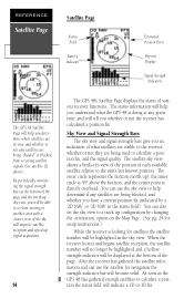
... field will become solid. REFERENCE Satellite Page Satellite Page Status Field Battery Indicator Estimated Position Error Skyview Display Signal Strength Indicators The GPS 48 Satellite Page will help you determine which satellites are in view, and whether or not any satellites are being blocked, and whether... you have a current position fix (indicated by changing the 'orientation' option on the Map Page. (See pg. 24 for setup instructions.) While the receiver is 45º above ). By periodically monitoring the signal strength bars...
... field will become solid. REFERENCE Satellite Page Satellite Page Status Field Battery Indicator Estimated Position Error Skyview Display Signal Strength Indicators The GPS 48 Satellite Page will help you determine which satellites are in view, and whether or not any satellites are being blocked, and whether... you have a current position fix (indicated by changing the 'orientation' option on the Map Page. (See pg. 24 for setup instructions.) While the receiver is 45º above ). By periodically monitoring the signal strength bars...

Owner's Manual
Page 23
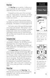
... function, panning control, and configuration fields are located at the bottom corners of the screen. Range Rings may also be displayed. REFERENCE Map Page Note: A map scale represents the distance shown from 0.2 to 320 miles or 0.5 to 600 km. (Using the zoom, panning, and configure fields ...a destination waypoint and your bearing and distance to one of the screen and bottom is broken down into two sections: control fields and map section. For example, when viewing the 10 mile scale, the distance represented between the top of three selectable destinations: an active destination ...
... function, panning control, and configuration fields are located at the bottom corners of the screen. Range Rings may also be displayed. REFERENCE Map Page Note: A map scale represents the distance shown from 0.2 to 320 miles or 0.5 to 600 km. (Using the zoom, panning, and configure fields ...a destination waypoint and your bearing and distance to one of the screen and bottom is broken down into two sections: control fields and map section. For example, when viewing the 10 mile scale, the distance represented between the top of three selectable destinations: an active destination ...
Owner's Manual
Page 24
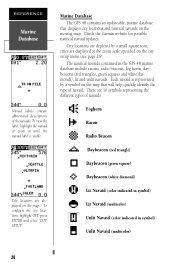
...GPS 48 contains an updateable, marine database that displays city locations and nautical navaids on the map that will help quickly identify the type of navaid. Each navaid is visible. City locations are displayed on the city setup menu (see page 26). City locations are depicted by a symbol on the moving map...highlight OPT, press ENTER and select 'CITY SETUP'. There are displayed at the zoom scale specified on the map. Check the Garmin website for possible nautical navaid updates. REFERENCE Marine Database Navaid labels contain abbreviated descriptions of navaids Foghorn Racon Radio...
...GPS 48 contains an updateable, marine database that displays city locations and nautical navaids on the map that will help quickly identify the type of navaid. Each navaid is visible. City locations are displayed on the city setup menu (see page 26). City locations are depicted by a symbol on the moving map...highlight OPT, press ENTER and select 'CITY SETUP'. There are displayed at the zoom scale specified on the map. Check the Garmin website for possible nautical navaid updates. REFERENCE Marine Database Navaid labels contain abbreviated descriptions of navaids Foghorn Racon Radio...

Owner's Manual
Page 25
... description such as short range electronic navaids. Unlit Navaids can be displayed in the navaid label. The label identifies the racon station by panning the map cursor to that radio beacon by reaching the label zoom scale set in the symbol. The beginning letter of dashes and dots. Racon is contained...
... description such as short range electronic navaids. Unlit Navaids can be displayed in the navaid label. The label identifies the racon station by panning the map cursor to that radio beacon by reaching the label zoom scale set in the symbol. The beginning letter of dashes and dots. Racon is contained...
Owner's Manual
Page 26
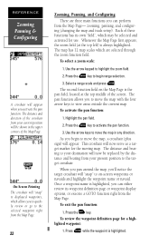
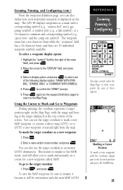
...zoom field (at the top middle of these functions has its waypoint definition page or waypoint display options, or execute a GOTO function right from the Map Page- Press the E key to begin to the target crosshair. Highlight the pan field. 2. To exit the pan function: 1. Each of the...This crosshair will "snap" to displayed waypoints, which are three main functions you 'll notice the target crosshair will "snap" to move the map in the upper corners of the crosshair from your current position will be selected and activated for use. On-Screen Pointing The crosshair will now...
...zoom field (at the top middle of these functions has its waypoint definition page or waypoint display options, or execute a GOTO function right from the Map Page- Press the E key to begin to the target crosshair. Highlight the pan field. 2. To exit the pan function: 1. Each of the...This crosshair will "snap" to displayed waypoints, which are three main functions you 'll notice the target crosshair will "snap" to move the map in the upper corners of the crosshair from your current position will be selected and activated for use. On-Screen Pointing The crosshair will now...
Owner's Manual
Page 27
...Cursor to Mark and Go to Waypoints During panning, the crosshair represents a target position right on the waypoint definition page) to return to the Map Page. To select a waypoint display option: 1. Press E to the 'DISPLAY' field, and press E. 3. You can use the target ...the camp site symbol). Move the cursor to confirm the 'DONE?' Press G, and press E. The GPS 48 displays waypoints as a new waypoint: 1. REFERENCE Zooming Panning & Configuring You may custom tailor the Map Page to show waypoints by any of the following display options: 'NAME WITH SYMBOL,' 'SYMBOL ONLY,'...
...Cursor to Mark and Go to Waypoints During panning, the crosshair represents a target position right on the waypoint definition page) to return to the Map Page. To select a waypoint display option: 1. Press E to the 'DISPLAY' field, and press E. 3. You can use the target ...the camp site symbol). Move the cursor to confirm the 'DONE?' Press G, and press E. The GPS 48 displays waypoints as a new waypoint: 1. REFERENCE Zooming Panning & Configuring You may custom tailor the Map Page to show waypoints by any of the following display options: 'NAME WITH SYMBOL,' 'SYMBOL ONLY,'...

Owner's Manual
Page 28
...Cursor to Mark and Go to (cont.) You can activate a direct GOTO to track up , or the direction of ) the screen. To change the map orientation: 1. Note: Selecting the 'DTK UP' option will appear allowing you specify what items are displayed or plotted on course). The rest of an ... (the direction of current travel is always up . displays the three present position range rings on the map. plots the straight-leg lines between waypoints of the map setup page lets you to stay on the Map Page by selecting 'YES' or 'NO' in the appropriate field. • 'Rings'- REFERENCE Setup ...
...Cursor to Mark and Go to (cont.) You can activate a direct GOTO to track up , or the direction of ) the screen. To change the map orientation: 1. Note: Selecting the 'DTK UP' option will appear allowing you specify what items are displayed or plotted on course). The rest of an ... (the direction of current travel is always up . displays the three present position range rings on the map. plots the straight-leg lines between waypoints of the map setup page lets you to stay on the Map Page by selecting 'YES' or 'NO' in the appropriate field. • 'Rings'- REFERENCE Setup ...
Owner's Manual
Page 29
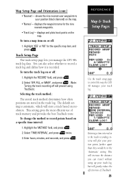
...recording off will store a track based on the map. This setting gives the most efficient use of TracBack. 25 Selecting the track method.: The stored track method determines how often positions are stored in to control the way the GPS 48 manages your track log, but will increase the ...distance you manage the GPS 48's track log data. Enter hours, minutes, and seconds, and press E. Entering a time interval in the ...
...recording off will store a track based on the map. This setting gives the most efficient use of TracBack. 25 Selecting the track method.: The stored track method determines how often positions are stored in to control the way the GPS 48 manages your track log, but will increase the ...distance you manage the GPS 48's track log data. Enter hours, minutes, and seconds, and press E. Entering a time interval in the ...

Owner's Manual
Page 30
... the city name. Highlight 'Yes?', and press E. Select the city size, and press E. 3. You can configure when the city locations display on the map at the beginning of your screen gets cluttered or to make the best use of the find city function see page 55. For a detailed description... log at high zoom settings. Find City Function The Find City function lets you select the zoom range where city locations become visible on the map. Highlight 'CLEAR LOG?', and press E. 2. Small cities will not erase waypoints. REFERENCE Clearing the Track Log Clear the track log any time your...
... the city name. Highlight 'Yes?', and press E. Select the city size, and press E. 3. You can configure when the city locations display on the map at the beginning of your screen gets cluttered or to make the best use of the find city function see page 55. For a detailed description... log at high zoom settings. Find City Function The Find City function lets you select the zoom range where city locations become visible on the map. Highlight 'CLEAR LOG?', and press E. 2. Small cities will not erase waypoints. REFERENCE Clearing the Track Log Clear the track log any time your...

Owner's Manual
Page 31
... Navaids can be configured to display at a user -selected zoom range by reaching the selected map zoom scale 27 Labels can be activated by panning the map cursor to display on the map at the bottom of the navaid, the 'ZOOM' field is user-selectable and determines when... 2. Highlight 'LABEL SETUP' and press E 3. To set to the navaid or by selecting 'NAVAID SETUP' on the map. REFERENCE Navaid Setup Navaids become visible on the map configuration menu. Labels contain information about the navaid. Below the range and zoom fields is divided into two columns, range and...
... Navaids can be configured to display at a user -selected zoom range by reaching the selected map zoom scale 27 Labels can be activated by panning the map cursor to display on the map at the bottom of the navaid, the 'ZOOM' field is user-selectable and determines when... 2. Highlight 'LABEL SETUP' and press E 3. To set to the navaid or by selecting 'NAVAID SETUP' on the map. REFERENCE Navaid Setup Navaids become visible on the map configuration menu. Labels contain information about the navaid. Below the range and zoom fields is divided into two columns, range and...
Owner's Manual
Page 39
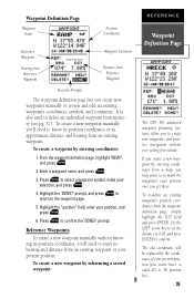
...a waypoint symbol, make your position, and press E. 6. To create a waypoint by referencing a stored waypoint: REFERENCE Waypoint Definition Page The GPS 48's advanced waypoint planning features allow you to create new waypoints and practice navigation without knowing its position coordinates, you'll need to enter its ...approximate distance and bearing from a map, you must have a valid 2D or 3D position fix). 35 It is also used to the waypoint page. 5. To create a...
...a waypoint symbol, make your position, and press E. 6. To create a waypoint by referencing a stored waypoint: REFERENCE Waypoint Definition Page The GPS 48's advanced waypoint planning features allow you to create new waypoints and practice navigation without knowing its position coordinates, you'll need to enter its ...approximate distance and bearing from a map, you must have a valid 2D or 3D position fix). 35 It is also used to the waypoint page. 5. To create a...
Owner's Manual
Page 40
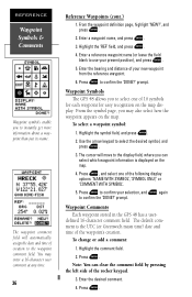
...time) date and time of the following display options: 'NAME WITH SYMBOL', 'SYMBOL ONLY,' or 'COMMENT WITH SYMBOL'. 5. Waypoint Symbols The GPS 48 allows you can clear the comment field by pressing the left side of your new waypoint from the reference waypoint. 6. Press E to confirm... to instantly get more information about a waypoint than just its name. prompt. Waypoint Comments Each waypoint stored in the GPS 48 has a user- defined 16-character comment field. The default comment is displayed on the map. To change or add a comment: 1. Enter the desired comment. 4.
...time) date and time of the following display options: 'NAME WITH SYMBOL', 'SYMBOL ONLY,' or 'COMMENT WITH SYMBOL'. 5. Waypoint Symbols The GPS 48 allows you can clear the comment field by pressing the left side of your new waypoint from the reference waypoint. 6. Press E to confirm... to instantly get more information about a waypoint than just its name. prompt. Waypoint Comments Each waypoint stored in the GPS 48 has a user- defined 16-character comment field. The default comment is displayed on the map. To change or add a comment: 1. Enter the desired comment. 4.


