Reference Guide
Page 5
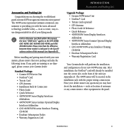
... Subscription Packet • Warranty Registration Card Upgrade Package: • Garmin 400W-series Unit • NavData® Card • Terrain Card (optional) • GPS Antenna • Pilot's Guide & Reference • Quick Reference • 400W/500W Series Display Interfaces Addendum • 400W/500W Series Garmin Optional Display Interfaces Addendum • GNS 400W/500W-series Simulator Training CD-ROM • Database Subscription...
... Subscription Packet • Warranty Registration Card Upgrade Package: • Garmin 400W-series Unit • NavData® Card • Terrain Card (optional) • GPS Antenna • Pilot's Guide & Reference • Quick Reference • 400W/500W Series Display Interfaces Addendum • 400W/500W Series Garmin Optional Display Interfaces Addendum • GNS 400W/500W-series Simulator Training CD-ROM • Database Subscription...
Reference Guide
Page 11
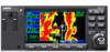
...either a 10-watt (GNS 420W) or 16-watt 28 V dc (GNS 420AW) COM. Pilots will be referred to a high-contrast color display, the information can be used to review the ... for oceanic or remote operations. The Index may be easily read from the Garmin GTX 330 Mode S transponder, or L3 SKYWATCH™, or STORMSCOPE® WX 500. Section ...rest of the 400W-series major features. INTRODUCTION Model Descriptions Model Descriptions This guide covers the operation of the GPS 400W, and also includes TSO'd airborne VHF communications transceiver. GPS 400W The GPS 400W has a WAAS GPS engine and ...
...either a 10-watt (GNS 420W) or 16-watt 28 V dc (GNS 420AW) COM. Pilots will be referred to a high-contrast color display, the information can be used to review the ... for oceanic or remote operations. The Index may be easily read from the Garmin GTX 330 Mode S transponder, or L3 SKYWATCH™, or STORMSCOPE® WX 500. Section ...rest of the 400W-series major features. INTRODUCTION Model Descriptions Model Descriptions This guide covers the operation of the GPS 400W, and also includes TSO'd airborne VHF communications transceiver. GPS 400W The GPS 400W has a WAAS GPS engine and ...

Reference Guide
Page 22
... the large right knob until a page from the desired group is displayed. See the 400W/500W Series Display Interfaces Pilot's Guide Addendum, part number 190-00356-31 and the 400W/500W Series Garmin Optional Displays Pilot's Guide Ad- The bottom right corner of the screen indicates the page group currently being displayed ... key. TAKEOFF TOUR Nav Pages Nav Pages The map page is one of seven, or more , NAV Pages are available when the 400W-series installation includes connection to traffic, XM radio, and/or weather information sources. To select the desired page group, turn the small...
... the large right knob until a page from the desired group is displayed. See the 400W/500W Series Display Interfaces Pilot's Guide Addendum, part number 190-00356-31 and the 400W/500W Series Garmin Optional Displays Pilot's Guide Ad- The bottom right corner of the screen indicates the page group currently being displayed ... key. TAKEOFF TOUR Nav Pages Nav Pages The map page is one of seven, or more , NAV Pages are available when the 400W-series installation includes connection to traffic, XM radio, and/or weather information sources. To select the desired page group, turn the small...

Reference Guide
Page 47
See 400W/500W Series Display Interfaces Pilot's Guide Addendum. Large cities are those with a control ...Setup Map?", "Measure Dist?", "Data Fields Off?", "Change Fields?" The following options are only available when the 400W-series unit installation includes connection to your preferences, including map orientation, land data enable/disable, Jeppesen data enable/...disable, automatic zoom, airspace boundaries, and text size. 2 - Map Setup "Setup Map?" Each of the 400W-series functions are greater than 50,000. 190-00356-00 Rev G 37 To display the map page options menu...
See 400W/500W Series Display Interfaces Pilot's Guide Addendum. Large cities are those with a control ...Setup Map?", "Measure Dist?", "Data Fields Off?", "Change Fields?" The following options are only available when the 400W-series unit installation includes connection to your preferences, including map orientation, land data enable/disable, Jeppesen data enable/...disable, automatic zoom, airspace boundaries, and text size. 2 - Map Setup "Setup Map?" Each of the 400W-series functions are greater than 50,000. 190-00356-00 Rev G 37 To display the map page options menu...
Reference Guide
Page 50
... fields on the four user-selectable data fields along the right-hand side of the screen. Traffic information is only available when the 400W-series installation includes connection to remove the cursor. Turn the small right knob to highlight "Change Fields?". See Section 11 for descriptions...(or "Data Fields On?"), then press ENT. To change . 3. To turn the large right knob to display a larger map area. See the 400W Series Pilot's Guide Addendum, part number 190-00356-31. 40 190-00356-00 Rev G option provides a full-screen map display (shown bottom right), without the four...
... fields on the four user-selectable data fields along the right-hand side of the screen. Traffic information is only available when the 400W-series installation includes connection to remove the cursor. Turn the small right knob to highlight "Change Fields?". See Section 11 for descriptions...(or "Data Fields On?"), then press ENT. To change . 3. To turn the large right knob to display a larger map area. See the 400W Series Pilot's Guide Addendum, part number 190-00356-31. 40 190-00356-00 Rev G option provides a full-screen map display (shown bottom right), without the four...

Reference Guide
Page 66
... helpful when you'd like to descend to a final (target) altitude at a specified location. The 400W-series vertical navigation page (the last NAV page) allows you to create a three-dimensional profile which guides you informed of the GPS naviga- 2 - The lowest numbers are the best accuracy and the highest numbers are the sole... and VFOM represent the 95% confidence levels in 3D navigation mode and computes altitude using Horizontal Figure of Merit (HFOM), Vertical Figure of the pilot. The GPS receiver is defined, message alerts and additional data on the satellite status page.
... helpful when you'd like to descend to a final (target) altitude at a specified location. The 400W-series vertical navigation page (the last NAV page) allows you to create a three-dimensional profile which guides you informed of the GPS naviga- 2 - The lowest numbers are the best accuracy and the highest numbers are the sole... and VFOM represent the 95% confidence levels in 3D navigation mode and computes altitude using Horizontal Figure of Merit (HFOM), Vertical Figure of the pilot. The GPS receiver is defined, message alerts and additional data on the satellite status page.

Reference Guide
Page 125
...interface with what the auto- pilot expects (i.e., angular CDI scaling and glideslope capture for autopilot outputs 1. Press PROC. Your autopilot will provide 4. with automatic CDI switching disabled: 5 - Conditions for an LPV or other vertically guided GPS approach. To enable autopilot outputs...prior to enable the autopilot outputs before using "Prompt" for an approach. 1. The 400W-series unit must be configured during the approach procedure. After enabling outputs, the 400W-series unit will now use "VLOC" guidance. 3. • When flying a ...
...interface with what the auto- pilot expects (i.e., angular CDI scaling and glideslope capture for autopilot outputs 1. Press PROC. Your autopilot will provide 4. with automatic CDI switching disabled: 5 - Conditions for an LPV or other vertically guided GPS approach. To enable autopilot outputs...prior to enable the autopilot outputs before using "Prompt" for an approach. 1. The 400W-series unit must be configured during the approach procedure. After enabling outputs, the 400W-series unit will now use "VLOC" guidance. 3. • When flying a ...

Reference Guide
Page 203
... expressed as "cumulative distance"). The time it will reach your present position to a ground position. The fuel flow rate, expressed in this Pilot's Guide: WPT 2 NORTH DTK BRG TRK XTK DIS miles per hour). The total of fuel consumption, expressed in distance per fuel units (e.g., nautical ...FOB (fuel on the 400W-series and in fuel WPT 1 units per time (e.g., gallons per gallon). DIS (distance)- The geodesic path from your destination waypoint, based ...
... expressed as "cumulative distance"). The time it will reach your present position to a ground position. The fuel flow rate, expressed in this Pilot's Guide: WPT 2 NORTH DTK BRG TRK XTK DIS miles per hour). The total of fuel consumption, expressed in distance per fuel units (e.g., nautical ...FOB (fuel on the 400W-series and in fuel WPT 1 units per time (e.g., gallons per gallon). DIS (distance)- The geodesic path from your destination waypoint, based ...


