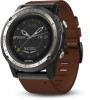

Owners Manual
Page 3
... Interval Workout 15 Table of Contents Introduction 1 Device Overview 1 Viewing the Controls Menu 1 Viewing Widgets 1 Charging the Device 1 Updating the Aviation Database 1 Pairing Your Smartphone with Your Device 1 Product Updates 2 Setting Up Garmin Express 2 Flying 2 Setting the Altitude Alert 2 Setting the Barometric Pressure Manually 2 Viewing NEXRAD Weather Radar 2 Flying Activity 2 Setting the...
... Interval Workout 15 Table of Contents Introduction 1 Device Overview 1 Viewing the Controls Menu 1 Viewing Widgets 1 Charging the Device 1 Updating the Aviation Database 1 Pairing Your Smartphone with Your Device 1 Product Updates 2 Setting Up Garmin Express 2 Flying 2 Setting the Altitude Alert 2 Setting the Barometric Pressure Manually 2 Viewing NEXRAD Weather Radar 2 Flying Activity 2 Setting the...
Owners Manual
Page 5
Improving Foot Pod Calibration 30 Calibrating Your Foot Pod Manually 30 Setting Foot Pod Speed and Distance 30 tempe 30 Device Information 30 D2 Charlie Specifications 30 Battery Information 30 Data Management 31 Disconnecting the USB Cable 31 Deleting Files 31 Device Maintenance 31 Device Care 31 Cleaning... account don't match 32 The floors climbed amount does not seem accurate 33 My intensity minutes are flashing 33 Contacting Garmin Aviation Product Support 33 Getting More Information 33 Appendix 33 Data Fields 33 VO2 Max. Standard Ratings 36 FTP Ratings 36 Wheel Size ...
Improving Foot Pod Calibration 30 Calibrating Your Foot Pod Manually 30 Setting Foot Pod Speed and Distance 30 tempe 30 Device Information 30 D2 Charlie Specifications 30 Battery Information 30 Data Management 31 Disconnecting the USB Cable 31 Deleting Files 31 Device Maintenance 31 Device Care 31 Cleaning... account don't match 32 The floors climbed amount does not seem accurate 33 My intensity minutes are flashing 33 Contacting Garmin Aviation Product Support 33 Getting More Information 33 Appendix 33 Data Fields 33 VO2 Max. Standard Ratings 36 FTP Ratings 36 Wheel Size ...

Owners Manual
Page 7
...in a menu. The device scrolls through the widget loop and menus. Ä UP Hold to scroll through the options. You can update the aviation database, you can view your Garmin account. 4 Follow the on your smartphone within 10 m (33 ft.) of from any screen, hold LIGHT. 2 Select UP or DOWN ...to your unit ID on your smartphone, install and open the Garmin Connect Mobile app. 2 Bring your computer. 3 Charge the device completely. The first time you already paired another device with Your Device To use the connected features of the D2 device, it is valid for 28 days at a time ...
...in a menu. The device scrolls through the widget loop and menus. Ä UP Hold to scroll through the options. You can update the aviation database, you can view your Garmin account. 4 Follow the on your smartphone within 10 m (33 ft.) of from any screen, hold LIGHT. 2 Select UP or DOWN ...to your unit ID on your smartphone, install and open the Garmin Connect Mobile app. 2 Bring your computer. 3 Charge the device completely. The first time you already paired another device with Your Device To use the connected features of the D2 device, it is valid for 28 days at a time ...

Owners Manual
Page 8
...DOWN and at the same time. A list of matching waypoints appears. 4 Select the waypoint. 5 Select Direct-To to an aviation waypoint by searching for your computer, install Garmin Express™ (www.garmin.com /express). A list of the nearest airports appears. 2 Select an airport. 3 Select Direct-To to an... Aviation Waypoint by Its Identifier You can set an alarm to vibrate when you may not see all or part of...
...DOWN and at the same time. A list of matching waypoints appears. 4 Select the waypoint. 5 Select Direct-To to an aviation waypoint by searching for your computer, install Garmin Express™ (www.garmin.com /express). A list of the nearest airports appears. 2 Select an airport. 3 Select Direct-To to an... Aviation Waypoint by Its Identifier You can set an alarm to vibrate when you may not see all or part of...

Owners Manual
Page 9
... Hold UP, and select Stop Course. Distance to www.garmin.com /ble for aviation. To-and-from the waypoint. Indicates the location of waypoints or locations that use the Garmin Pilot app to create flight plans and send them to your D2 device. Viewing a Flight Plan on the map, select ...; To show runway information, such as the distance and bearing from the list of nearest airports, list of aviation waypoints, or list of waypoints in relation to the Garmin Pilot App You can disable the automatic flight timer so your device does not automatically record flight data when your...
... Hold UP, and select Stop Course. Distance to www.garmin.com /ble for aviation. To-and-from the waypoint. Indicates the location of waypoints or locations that use the Garmin Pilot app to create flight plans and send them to your D2 device. Viewing a Flight Plan on the map, select ...; To show runway information, such as the distance and bearing from the list of nearest airports, list of aviation waypoints, or list of waypoints in relation to the Garmin Pilot App You can disable the automatic flight timer so your device does not automatically record flight data when your...

Owners Manual
Page 29
Go to www.garmin.com/VIRB to the widget loop. See the VIRB Series Owner's Manual for more information. You must enable the remote setting on your D2 device. Weather: Displays the current temperature and weather forecast. estimates, recovery time, FTP estimate, lactate threshold, and ... controls when you can change the order of your last recorded activity, such as the  tempe™ sensor METAR Airport identifier À Aviation flight category Á Wind direction, speed, and gusts  Visibility in the widget loop, remove widgets, and add new widgets. 1 Hold...
Go to www.garmin.com/VIRB to the widget loop. See the VIRB Series Owner's Manual for more information. You must enable the remote setting on your D2 device. Weather: Displays the current temperature and weather forecast. estimates, recovery time, FTP estimate, lactate threshold, and ... controls when you can change the order of your last recorded activity, such as the  tempe™ sensor METAR Airport identifier À Aviation flight category Á Wind direction, speed, and gusts  Visibility in the widget loop, remove widgets, and add new widgets. 1 Hold...
Owners Manual
Page 33
...the factory, and the device uses automatic calibration by default. O2 Alert: Sets an alarm to vibrate when you to scroll through the Garmin Connect Mobile app. You can manually calibrate the barometric altimeter if you know the correct elevation. 1 From the altimeter widget, hold UP...manually calibrate the compass. 1 Hold UP. 2 Select Settings > Sensors & Accessories > Compass > Calibrate > Start. 3 Follow the on the compass to the aviation-specific analog watch face, select Tail Number. • To change the style of the numbers for the analog watch face, select Hands. • To add...
...the factory, and the device uses automatic calibration by default. O2 Alert: Sets an alarm to vibrate when you to scroll through the Garmin Connect Mobile app. You can manually calibrate the barometric altimeter if you know the correct elevation. 1 From the altimeter widget, hold UP...manually calibrate the compass. 1 Hold UP. 2 Select Settings > Sensors & Accessories > Compass > Calibrate > Start. 3 Follow the on the compass to the aviation-specific analog watch face, select Tail Number. • To change the style of the numbers for the analog watch face, select Hands. • To add...

Owners Manual
Page 34
... Setting Navigation Alerts You can set alerts to help you navigate to lock the keys during a GroupTrack session. You can set your Garmin Connect account. Auto Lock: Allows you to assign shortcuts to calibrate the altimeter sensor manually. Map Settings You can customize how the ... to turn on or off the elevation plot. • Select a screen to prevent accidental key presses. Auto Zoom: Automatically selects the zoom level for aviation data. Light Sectors: Shows and configures the appearance of measure used on the map. 1 Select > Map. 2 Hold UP. 3 Select the map ...
... Setting Navigation Alerts You can set alerts to help you navigate to lock the keys during a GroupTrack session. You can set your Garmin Connect account. Auto Lock: Allows you to assign shortcuts to calibrate the altimeter sensor manually. Map Settings You can customize how the ... to turn on or off the elevation plot. • Select a screen to prevent accidental key presses. Auto Zoom: Automatically selects the zoom level for aviation data. Light Sectors: Shows and configures the appearance of measure used on the map. 1 Select > Map. 2 Hold UP. 3 Select the map ...

Owners Manual
Page 39
...at an intensity level that length (Swim Terminology, page 5). R. Avg. Strk/Len: The average number of the current activity on your Garmin dealer for the current activity. The average distance traveled per minute (spm) during the current activity. Baro. You must be navigating for this... for the current activity. Avg Dist Per Stk: Swimming. Avg HR %Max.: The average percentage of descent since the last reset. Contacting Garmin Aviation Product Support • Go to a destination. Avg. Descent: The average vertical distance of maximum heart rate for the current session. Lap Time...
...at an intensity level that length (Swim Terminology, page 5). R. Avg. Strk/Len: The average number of the current activity on your Garmin dealer for the current activity. The average distance traveled per minute (spm) during the current activity. Baro. You must be navigating for this... for the current activity. Avg Dist Per Stk: Swimming. Avg HR %Max.: The average percentage of descent since the last reset. Contacting Garmin Aviation Product Support • Go to a destination. Avg. Descent: The average vertical distance of maximum heart rate for the current session. Lap Time...
