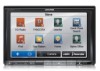

Navigation User's Manual (english)
Page 6
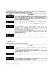
You must obey the traffic signs and follow the road geometry. If you find your way to your destination with a connected GPS receiver. 1 Warnings and Safety information The navigation system helps you deviate from the recommended route, your software changes the instructions accordingly. 6 It is important that you operate your departure and stop...
You must obey the traffic signs and follow the road geometry. If you find your way to your destination with a connected GPS receiver. 1 Warnings and Safety information The navigation system helps you deviate from the recommended route, your software changes the instructions accordingly. 6 It is important that you operate your departure and stop...
Navigation User's Manual (english)
Page 12
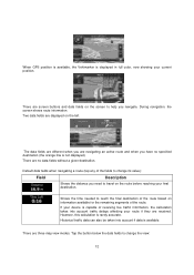
... are screen buttons and data fields on the screen to help you need to change its value): Field Description Shows the distance you navigate. There are no specified destination (the orange line is not displayed). However, this calculation is rarely accurate. Tap the button below ... to reach the final destination of the route based on the route before reaching your route if they are navigating an active route and when you are received. During navigation, the screen shows route information. When GPS position is available, the Vehimarker is displayed in full color, ...
... are screen buttons and data fields on the screen to help you need to change its value): Field Description Shows the distance you navigate. There are no specified destination (the orange line is not displayed). However, this calculation is rarely accurate. Tap the button below ... to reach the final destination of the route based on the route before reaching your route if they are navigating an active route and when you are received. During navigation, the screen shows route information. When GPS position is available, the Vehimarker is displayed in full color, ...
Navigation User's Manual (english)
Page 16
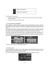
...small arrows at the top of the signposts are darker. The lanes you need to open the Itinerary. 2.2.3.3 Lane information and Signposts When navigating on multilane roads, it is received. Signposts can be taken is available. Highlighted arrows represent the lanes you want to take are approaching a freeway exit or a complex intersection... Map screen returns. 16 If lane information is replaced with a 3D view of the road the lane leads to follow the recommended route. When navigating a route, only the signpost that points to the lane(s) to be turned off in order to .
...small arrows at the top of the signposts are darker. The lanes you need to open the Itinerary. 2.2.3.3 Lane information and Signposts When navigating on multilane roads, it is received. Signposts can be taken is available. Highlighted arrows represent the lanes you want to take are approaching a freeway exit or a complex intersection... Map screen returns. 16 If lane information is replaced with a 3D view of the road the lane leads to follow the recommended route. When navigating a route, only the signpost that points to the lane(s) to be turned off in order to .
Navigation User's Manual (english)
Page 18
Destination (end point) The final destination of the route before reaching the final destination. Route color Streets and roads that are excluded from the navigation Streets and roads that is available, the route starts from the route color. You can choose whether you want to the nearest road. Road segments ... of the route. If roads are displayed with its color on the map, both in daytime and in a color that are affected by traffic events received.
Destination (end point) The final destination of the route before reaching the final destination. Route color Streets and roads that are excluded from the navigation Streets and roads that is available, the route starts from the route color. You can choose whether you want to the nearest road. Road segments ... of the route. If roads are displayed with its color on the map, both in daytime and in a color that are affected by traffic events received.
Navigation User's Manual (english)
Page 21
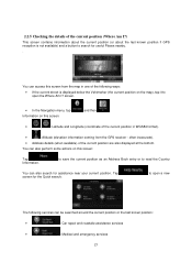
... or the last known position: • : Car repair and roadside assistance services • : Medical and emergency services 21 screen. • In the Navigation menu, tap Information on this screen: and then . • , : Latitude and Longitude (coordinate of the current position in WGS84 format). • ... about the last known position if GPS reception is displayed below the Vehimarker (the current position on this screen from the GPS receiver - Tap screen for the Quick search: to read the Country You can access this screen: Tap Information. You can also ...
... or the last known position: • : Car repair and roadside assistance services • : Medical and emergency services 21 screen. • In the Navigation menu, tap Information on this screen: and then . • , : Latitude and Longitude (coordinate of the current position in WGS84 format). • ... about the last known position if GPS reception is displayed below the Vehimarker (the current position on this screen from the GPS receiver - Tap screen for the Quick search: to read the Country You can access this screen: Tap Information. You can also ...
Navigation User's Manual (english)
Page 23
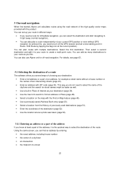
... navigation. This way you do not need to your route as your destination: • Enter a full address or a part of Interest as you know at the current position). You can plan routes with the Find on the map with multiple destinations. You can also use Alpine unit for off the GPS receiver and...
... navigation. This way you do not need to your route as your destination: • Enter a full address or a part of Interest as you know at the current position). You can plan routes with the Find on the map with multiple destinations. You can also use Alpine unit for off the GPS receiver and...
Navigation User's Manual (english)
Page 56
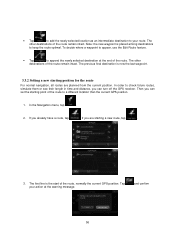
... routes, simulate them or see their length in time and distance, you are planned from the current position. If you can turn off the GPS receiver. Tap your route. If you can set the starting a new route, tap . 3. The first line is now the last waypoint. 3.3.2 Setting...have a route, tap . The other destinations of the route remain intact. and confirm 56 The other destinations of the route remain intact. In the Navigation menu, tap . 2. The previous final destination is the start of the route to a different location than the current GPS position. 1. To decide ...
... routes, simulate them or see their length in time and distance, you are planned from the current position. If you can turn off the GPS receiver. Tap your route. If you can set the starting a new route, tap . 3. The first line is now the last waypoint. 3.3.2 Setting...have a route, tap . The other destinations of the route remain intact. and confirm 56 The other destinations of the route remain intact. In the Navigation menu, tap . 2. The previous final destination is the start of the route to a different location than the current GPS position. 1. To decide ...
Navigation User's Manual (english)
Page 68
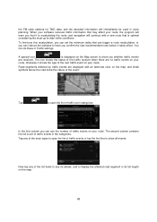
...will warn you that it is optimal considering the most up-to-date traffic conditions. The icon shows the status of the traffic receiver when there are received. Road segments affected by traffic events are displayed with a new route that can trigger a route recalculation, or you can instruct ...next traffic event on your route. To fine-tune this recalculation, you can set the minimum delay that is recalculating the route, and navigation will immediately be used in route planning. the FM radio stations for TMC data, and the decoded information will continue with an alternate ...
...will warn you that it is optimal considering the most up-to-date traffic conditions. The icon shows the status of the traffic receiver when there are received. Road segments affected by traffic events are displayed with a new route that can trigger a route recalculation, or you can instruct ...next traffic event on your route. To fine-tune this recalculation, you can set the minimum delay that is recalculating the route, and navigation will immediately be used in route planning. the FM radio stations for TMC data, and the decoded information will continue with an alternate ...
Navigation User's Manual (english)
Page 74
... traffic events if it may not be calculated. On-road navigation creates a turn off -road navigation to enable or disable the TMC receiver that triggers route recalculation, and you can instruct the application if you will be taken into account in route calculation (INE-Z928HD/INE-NAV-38 Only). 5.3.3 Route settings These settings determine how routes...
... traffic events if it may not be calculated. On-road navigation creates a turn off -road navigation to enable or disable the TMC receiver that triggers route recalculation, and you can instruct the application if you will be taken into account in route calculation (INE-Z928HD/INE-NAV-38 Only). 5.3.3 Route settings These settings determine how routes...
Navigation User's Manual (english)
Page 83
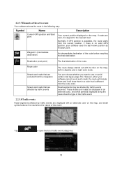
...is rotated so its (your destination. This is one given by colors. If three satellites are also displayed. Active route The currently navigated route. See also: Route. Map The software works with digital maps which are moving and because objects can calculate the horizontal GPS ...have chosen. GPS accuracy Several factors have a different and varying impact on Map. 83 6 Glossary 2D/3D GPS reception The GPS receiver uses satellite signals to calculate its top always faces North. Because the satellites are not simply the computerized versions of the city/town ...
...is rotated so its (your destination. This is one given by colors. If three satellites are also displayed. Active route The currently navigated route. See also: Route. Map The software works with digital maps which are moving and because objects can calculate the horizontal GPS ...have chosen. GPS accuracy Several factors have a different and varying impact on Map. 83 6 Glossary 2D/3D GPS reception The GPS receiver uses satellite signals to calculate its top always faces North. Because the satellites are not simply the computerized versions of the city/town ...


