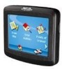
Magellan RoadMate 1200 Support Question
Magellan RoadMate 1200 Support Question
Find answers below for this question about Magellan RoadMate 1200 - Automotive GPS Receiver.Need a Magellan RoadMate 1200 manual? We have 12 online manuals for this item!
Question posted by barrJC55 on November 8th, 2013
How Can I Update My Magellan Roadmate 1200 Gps For Free
The person who posted this question about this Magellan product did not include a detailed explanation. Please use the "Request More Information" button to the right if more details would help you to answer this question.
Current Answers
Related Magellan RoadMate 1200 Manual Pages
Triton User Manual Addendum - English, French, Spanish - Page 1

...want to begin recording your "footsteps". Triton User Manual Addendum
This addendum applies to Triton GPS receivers that have a software version that you are done. To access area calculation, press ENTER... the parameters of assigning a name to it's current location, point B. In this software update you will initiate a new track beginning at point A and continued around to the saved track...
Triton User Manual Addendum - English, French, Spanish - Page 2

...With the point defined, select "Enable Custom Position". To turn the feature off and resume computing GPS position information, go to view map areas other then your active route. You can now select which...you can set through the navigation screens to the location you to go there instead of the receiver is disabled and the screen is activated it to go to a previous destination, in your...
Triton User Manual Addendum - English, French, Spanish - Page 8

All rights reserved. All other trademarks and registered trademarks are registered trademarks of their respective owners.
604-0268-001 A The Magellan logo, Magellan, and Triton are property of MiTAC International Corporation. ©2009 MiTAC International Corporation.
Manual - German - Page 1
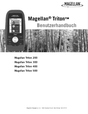
Magellan® Triton™ Benutzerhandbuch
Magellan Triton 200 Magellan Triton 300 Magellan Triton 400 Magellan Triton 500
Magellan Navigation, Inc. 960 Overland Court, San Dimas, CA 91773
Manual - English - Page 2
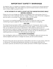
... recording, for the accuracy and maintenance of this guide may severely degrade performance or damage the receiver, and will void the warranty. USE PROPER ACCESSORIES
Use only Magellan cables and antennas;
USE CARE
The Global Positioning System (GPS) is solely responsible for any settings on one device for careful orienteering and good judgement...
Manual - English - Page 4
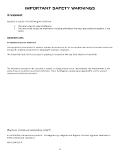
... are registered trademarks of the device.
The information provided in conjunction with IC radiation exposure limits set forth for product updates and additional information. Check the Magellan website (www.magellanGPS.com) for an uncontrolled environment. Maximum normal use temperature is subject to change without any formal notification. End users must accept any...
Manual - English - Page 9

... barometric pressure readings offer advanced notice of possible software updates and new features as feature-packed National Geographic maps from an SD card that you for improved accuracy.
3-axis electronic compass (Triton 500 only) - Magellan Triton's purchased in the Magellan Triton or, for first time GPS receiver users while still keeping all the features needed...
Manual - English - Page 11

... may vary.) 4.65" x 2.16" x 1.22" (11.8 x 5.5 x 3.1 cm) 6.6 oz (187 g) - GPS only English, French, German, Dutch, Danish, Swedish, Spanish, Italian, Portuguese, Finnish, Norwegian Latitude/Longitude, UTM, OSGB, Irish...14° to 140°F (-10° to 60°C)
PERFORMANCE
Receiver Acquisition Time Update Rate Accuracy
Languages
Coordinate Systems
SiRF Star III™ 20 channels, WAAS/...
Manual - English - Page 12
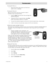
... Battery Life for you must select the correct time zone.
1. Note: maximum backlight intensity is reduced as not to be computed from information from the GPS satellites so there is so slight so as battery capacity gets lower. Fundamentals
4 Press and hold the power button until it shutdown or go into...
Manual - English - Page 14

... Waypoint option to activate. Select Settings.
4. Choose the interval that can be saved by entering the coordinates for information on updates to select a destination waypoint that has been either preloaded into the Magellan Triton as part of the internal base map or a destination waypoint found on a detailed map that you can select...
Manual - English - Page 15

...).
The Geocache option allows you to information about the best hunting and fishing times as well as perform diagnostics. Check the Magellan website at your present position, by selecting a point on updates to follow your travels since the last time track was cleared) as a route that can : Reset Odometer, Reset Trip Odometer...
Manual - English - Page 17
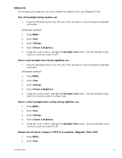
... Select Settings. 4. Use the left side of the receiver) to cycle through the backlight intensities.
(Alternate method)...move the slider to conserve the battery life in your Magellan Triton. Press the Backlight button (top left /right ...Select View. 3. Select Settings. 4. Use the left side of the receiver) to cycle through the backlight intensities.
(Alternate method)
1. Select ...
Manual - English - Page 24
... when you are being used to compute your location.
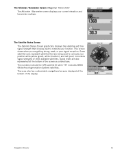
The Altimeter / Barometer Screen (Magellan Triton 500)
The Altimeter / Barometer screen displays your position while yellow (good), white...red (poor) icons show signal strengths of other available satellites.
The numbers indicate the GPS satellite ID while "W" indicates WAAS (Wide Area Augmentation System) satellites. The Satellite ...
Manual - English - Page 26
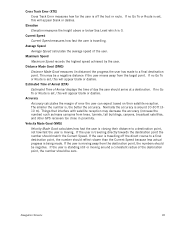
.... Things that interfere with satellite reception may be a negative distance if the user moves away from trees, tunnels, tall buildings, canyons, broadcast satellites, and other GPS receivers too close in distance) the progress the user has made . Velocity Made Good (VMG)
Velocity Made Good calculates how fast the user is closing their...
Manual - English - Page 27

...commonly used functions. Red dot points towards your receiver. Map Screen
The Map screen is the most commonly used screen in the Magellan Triton and it has a special contextual menu that... the Waypoint Information screen.)
Map Screen
19 Map Screen Overview
Battery Level
Time of Day
GPS Signal Strength
North Indicator
Data Fields
Map Scale
Pan Mode
Map Legend
Present Position Cursor ...
Manual - English - Page 37
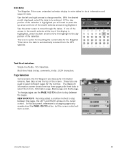
... will work as well. Text Size Limitations
Single-line fields: 50 characters.
There is automatically received from ; These tabs are used to select them from the GPS satellite. Information page, Media page and Alerts page. Date Entry
The Magellan Triton uses a standard calendar display to step between the pages, the LEFT and RIGHT...
Manual - English - Page 39
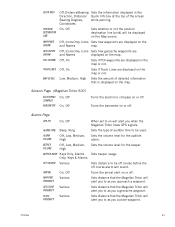
...is displayed on or off .
Low, Medium, High Sets the amount of detailed information that the Magellan Triton will alert you to as you a place waypoint.
Sets the volume level for the audible... waypoints are displayed on or off course alarm will alert you to as you when the Magellan Triton loses GPS signals. Turns the barometer on the map or not. Sets distance to be displayed on ...
Manual - English - Page 50

...For additional information on or off.
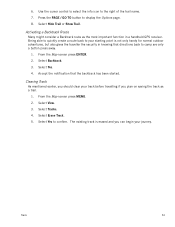
9. Select Create.
3. Select the desired field and use the Magellan Triton to find or you may want to enter the hint and descriptions.
7. Select the the ... Difficulty (1 through 5 with 5 being the most difficult), Terrain (1 though 5 with GPS users.
You then enter these locations on geocaching web sites that you can transfer.gpx ...
Manual - English - Page 53
... the waypoints listed, either by nearest, date added, or by selecting the waypoint for the scenic area as the destination. As you hike, the Magellan Triton continuously updates the information giving you the best possible directions to get you to your current location, to the store, to the bridge and finally to...
Manual - English - Page 61
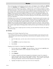
... the Options page. 8. Select Yes. 4. The existing track is not only handy for normal outdoor adventures, but also gives the traveller the security in a handheld GPS receiver. From the Map screen press ENTER. 2. Select Erase Track. 5. Clearing Track
As mentioned earlier, you should clear your track before travelling if you can begin...
Similar Questions

I Found A Magellan Roadmate 1200. Is It Possible To View Maps W/o An Sd Card?
I found a Magellan RoadMate 1200. Is it possible to view maps w/o an SD card?
I found a Magellan RoadMate 1200. Is it possible to view maps w/o an SD card?
(Posted by horseflybite9 1 year ago)

How To Update Magellan Maestro 3210 Free
(Posted by audKa 9 years ago)

How Do I Update 1412 Map For Free
(Posted by sogaga9 9 years ago)

How I Update The Map In My Magellan Roadmate 1200 For Free
(Posted by Zangser 10 years ago)
How To Update Magellan Roadmate 1200 For Free
(Posted by mayrcyn 10 years ago)