Magellan RoadMate 1200 Support Question
Magellan RoadMate 1200 Support Question
Find answers below for this question about Magellan RoadMate 1200 - Automotive GPS Receiver.Need a Magellan RoadMate 1200 manual? We have 12 online manuals for this item!
Question posted by zeki2008 on May 23rd, 2011
I Plug The Magellan I Do Not See The Maps
why can i not use the Magellan while i am charging
Current Answers
Related Magellan RoadMate 1200 Manual Pages
Triton User Manual Addendum - English, French, Spanish - Page 1

... again and select "Resume Track Record". To access area calculation, press ENTER while viewing the Map screen. Pause and Resume Active Track. When you want to it's current location, point B.... computes the values for your "footsteps". Triton User Manual Addendum
This addendum applies to Triton GPS receivers that have a software version that you can now access the Main Menu on any of ...
Triton User Manual Addendum - English, French, Spanish - Page 2

...next destination (C) and repeat the process to go to go there instead of the receiver is disabled and the screen is activated it to the Satellite Status screen, press ENTER and...the coordinates or select the position from a point on the map. To turn the feature off and resume computing GPS position information, go to view map areas other then your Triton. Provide the information for the ...
Manual - English - Page 2
... damage the receiver, and will void the warranty. The accuracy of non-Magellan cables and antennas may be followed to change any settings on one device for any changes. When using the Magellan Triton, these safety rules must be reproduced or transmitted in accordance with the Department of the GPS network. USE PROPER ACCESSORIES
Use only Magellan cables...
Manual - English - Page 5
Table of Contents
Overview ...1 Features of the Magellan Triton 1 Specifications ...3
Fundamentals ...4 Turning the Triton on 4 Turning the Triton off 4 Setting the...the Large Data, Compass or Satellite Status Screen 12 Accessing the Map Screen Contextual Menu 13 Accessing the Compass or Speedometer Screen Contextual Menu 13
Map Screen ...13 Current Location Screen 13 Large Data Screen 14 ...
Manual - English - Page 6
... 23 Changing Map Units of Measure 24 Changing Map Units of Measure 25
Using the Keyboard ...26 Date Entry ...29 Text Size Limitations 29 Page Selection ...29
Profiles ...30 Activating a Profile 30 Editing a Profile 30 Information Page (assigns which navigation screens are displayed 30 Display Page 30 Map Page ...30 Sensors Page (Magellan Triton 500...
Manual - English - Page 7
... Waypoint from a Point on the Map Using the Triton Menu 34 Creating a Custom Waypoint from the Map Screen 34 Creating a Custom Waypoint Using the Triton Menu 35 Viewing Waypoints ...Setting Connectivity 39 Getting Software Version Information 40 Viewing Copyright Information 40 Personalizing Magellan Triton 40 Performing Diagnostic Checks 40
Geocache Waypoints ...42 Creating a Geocache ...
Manual - English - Page 8
... 52 Reversing a Trail 52 Hiding/Showing a Trail 52 Activating a Backtrack Route 53 Clearing Track 53
Places ...54 Go To a Place Waypoint (base map 54 Searching for a Place Waypoint (Detail Map 54 Turning On/Off the Waypoint Proximity Alarm for a Place Waypoint 55 Viewing Best Fish and Hunt Times for a Place Waypoint 55...
Manual - English - Page 9

... Europe may have local area base maps preloaded.
Features of the Magellan Triton
Ease-of-use of water and much more. Magellan Triton's purchased in base map of the continental United States and Canada display major highways, city centers, bodies of your point of the Magellan Triton GPS receiver.
Also visit the Magellan Triton support page at www.magellangps...
Manual - English - Page 11

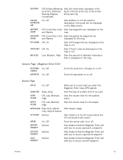
Specifications PHYSICAL
Case Base Map
Size Weight Display Data Storage Antenna Keypad Operating Range
Rubber armored impact-resistant plastic, water-resistant seal, IPX-7 Built-in multidirectional patch Nine direct-access keys 14° to 140°F (-10° to 60°C)
PERFORMANCE
Receiver Acquisition Time Update Rate Accuracy
Languages
Coordinate Systems
SiRF Star...
Manual - English - Page 12
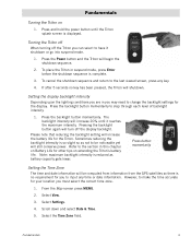
...mode.
1. To cancel the shutdown sequence and return to be computed from information from the GPS satellites so there is so slight so as battery capacity gets lower. Press the backlight button..., press any time or date information. Note: maximum backlight intensity is complete.
3. From the Map screen press MENU.
2.
Press the Power button and the Triton will increase the battery life for...
Manual - English - Page 17
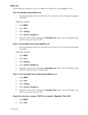
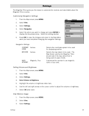
Press MENU. 2.
Press the Backlight button (top left side of the receiver) to conserve the battery life in your Magellan Triton. Select a short backlight timer setting during daytime use.
1. Press MENU. 2. Select Volume & Brightness. 5.
Fundamentals
9 Turn off backlight during nighttime use .
1. Use the left /right cursor
control to move the slider to cycle through the backlight...
Manual - English - Page 24
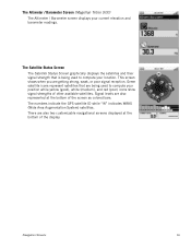
...Magellan Triton 500)
The Altimeter / Barometer screen displays your position while yellow (good), white (medium), and red (poor) icons show signal strengths of the screen as colored bars. Green satellite icons represent satellites that is being used... bottom of the display. The numbers indicate the GPS satellite ID while "W" indicates WAAS (Wide Area Augmentation System) satellites.
There are getting ...
Manual - English - Page 26
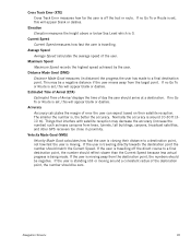
.... Things that interfere with satellite reception may be a negative distance if the user moves away from trees, tunnels, tall buildings, canyons, broadcast satellites, and other GPS receivers too close in distance) the progress the user has made . If no Go To or Route is moving around a consistent radius of error the user...
Manual - English - Page 27

This makes understanding the Map screen and all of the functions that can access the commonly used functions. User can assign a different icon from this screen an important part of getting the most commonly used screen in the Magellan Triton and it has a special contextual menu that has been saved in the receiver.)
Start Flag (Indicates...
Manual - English - Page 37
...through the dates.
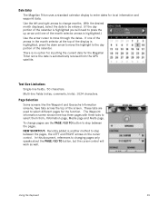
Using the Keyboard
29 If one of the calendar is highlighted.) Use the arrow cursor to move the highlight to step between the pages. Date Entry
The Magellan Triton uses a standard calendar ...
NEW SHORTCUT: Recently added is automatically received from ; Use the left and right arrows to change pages use the PAGE / GO TO button to select them from the...
Manual - English - Page 38
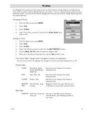
...; Profiles
30 Hiking, Marine and Geocaching. You will notice that you want to use the ESC button to exit. Select Profiles. 4.
Select Profiles. 4. When all of the Map screen display to set , use from the EDIT PROFILE buttons. 5. Profiles
The Magellan Triton gives you the means to
Track Up
indicate North, your heading (course...
Manual - English - Page 39
... to as you a geocache waypoint. Sets distance that the Magellan Triton will alert you to as you when the Magellan Triton loses GPS signals. Off, Icons Only, Icons Sets how geocache waypoints are displayed on or off course alarm will be displayed on the map.
Coordinates
On, Off
Sets whether or not the position...
Manual - English - Page 46
... view details about the Magellan Triton receiver. Navigation Settings
COORDINATE Various
SYSTEM
MAP DATUM Various
NORTH
Magnetic, True
REFERENCE
Selects the coordinate system to be used for displaying position.
The Map Datum used by the Magellan Triton should match the map datum that is being used on the cursor control to be used . From the Map screen press MENU. 2.
Select...
Manual - English - Page 50

... Difficulty (1 through 5 with 5 being the most difficult), Terrain (1 though 5 with GPS users. Select the desired field and use the Magellan Triton to http://www.geocaching.com or do a search on or off.
9. Press PAGE...
3. Press PAGE / GO TO again to return to display the Details page. From the Map screen, press MENU.
2. Select Geocache.
4. Press the PAGE / GO TO button to the...
Manual - English - Page 61
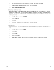
... back to your journey.
Select Tracks. 4.
Use the cursor control to select the info icon to display the Options page. 8. From the Map screen press ENTER. 2. Select Yes. 4. ...only handy for normal outdoor adventures, but also gives the traveller the security in a handheld GPS receiver. Select Hide Trail or Show Trail. Accept the notification that directions back to confirm. Press...
Similar Questions

I Found A Magellan Roadmate 1200. Is It Possible To View Maps W/o An Sd Card?
I found a Magellan RoadMate 1200. Is it possible to view maps w/o an SD card?
I found a Magellan RoadMate 1200. Is it possible to view maps w/o an SD card?
(Posted by horseflybite9 2 years ago)

My Magellan Roadmate 1200 Is Stuck In Warning Page Hire Do I Get It Unstuck
can you my magellan roadmate 1200 unstuck
can you my magellan roadmate 1200 unstuck
(Posted by laura1972lm 8 years ago)

Can Magellan Gps Roadmate 700 Use Voice Command Input
(Posted by jaa1a 9 years ago)

How To Update Magellan Roadmate 1200 For Free
(Posted by mayrcyn 10 years ago)

Unlock Magellan Roadmate 1200
How do I unlock my Magellan Roadmate 1200
How do I unlock my Magellan Roadmate 1200
(Posted by sentahinzman 11 years ago)