Magellan RoadMate 1200 Support Question
Magellan RoadMate 1200 Support Question
Find answers below for this question about Magellan RoadMate 1200 - Automotive GPS Receiver.Need a Magellan RoadMate 1200 manual? We have 12 online manuals for this item!
Question posted by Belangl on March 12th, 2014
How To Put Maps On Sd Card Magellan Roadmate 1200
The person who posted this question about this Magellan product did not include a detailed explanation. Please use the "Request More Information" button to the right if more details would help you to answer this question.
Current Answers
Related Magellan RoadMate 1200 Manual Pages
Manual - English - Page 5
Table of Contents
Overview ...1 Features of the Magellan Triton 1 Specifications ...3
Fundamentals ...4 Turning the Triton on 4 Turning the Triton off 4 Setting the...the Large Data, Compass or Satellite Status Screen 12 Accessing the Map Screen Contextual Menu 13 Accessing the Compass or Speedometer Screen Contextual Menu 13
Map Screen ...13 Current Location Screen 13 Large Data Screen 14 ...
Manual - English - Page 6
... 29 Page Selection ...29
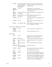
Profiles ...30 Activating a Profile 30 Editing a Profile 30 Information Page (assigns which navigation screens are displayed 30 Display Page 30 Map Page ...30 Sensors Page (Magellan Triton 500 31 Alarms Page ...31
Waypoints ...32 Waypoint Detail Screen Overview 32 Creating Waypoints 33 Creating a Current Location Waypoint from the...
Manual - English - Page 7
... 33 Creating a Waypoint from a Point on the Map Using the Triton Menu 34 Creating a Custom Waypoint from the Map Screen 34 Creating a Custom Waypoint Using the Triton ... 39 Setting Connectivity 39 Getting Software Version Information 40 Viewing Copyright Information 40 Personalizing Magellan Triton 40 Performing Diagnostic Checks 40
Geocache Waypoints ...42 Creating a Geocache Waypoint 42...
Manual - English - Page 8
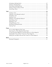
... 52 Reversing a Trail 52 Hiding/Showing a Trail 52 Activating a Backtrack Route 53 Clearing Track 53
Places ...54 Go To a Place Waypoint (base map 54 Searching for a Place Waypoint (Detail Map 54 Turning On/Off the Waypoint Proximity Alarm for a Place Waypoint 55 Viewing Best Fish and Hunt Times for a Place Waypoint 55...
Manual - English - Page 9

... only) Use an optional SD memory card to add detailed maps - Features of the Magellan Triton
Ease-of changing weather conditions. Get accurate compass readings while standing still, even without a GPS fix, and no matter how you hold the receiver. (GPS receivers without an electronic compass require that can be kept informed of the Magellan Triton GPS receiver. Magellan Triton's purchased in...
Manual - English - Page 10
A
B
C E
F G
D I
H
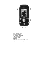
Magellan Triton
A Backlight Button B Power Button C Zoom - (Zoom out) Button D Zoom + (Zoom in) Button E ENTER Button / Cursor Control F PAGE / GO TO Button G Esc (Escape) Button H Menu Button I SD Card Slot (under protective rubber cover)
[Magellan Triton 400 & 500 only]
Overview
2
Manual - English - Page 11

... (5.59cm) diagonal, QVGA (240 x 320) resolution, LED backlit Internal memory or Secure Digital (SD) Card (optional accessory)
Built-in base map of the continental United States and Canada.
(In Europe, base map coverage may vary.) 4.65" x 2.16" x 1.22" (11.8 x 5.5 x 3.1 cm) 6.6 oz (187 g) - GPS only English, French, German, Dutch, Danish, Swedish, Spanish, Italian, Portuguese, Finnish, Norwegian...
Manual - English - Page 14

...route.
You can select the trail that has been loaded on an optional SD card (400 & 500) or into the Magellan Triton. Check the Magellan website at www.magellangps.com for a known waypoint. The Create Menu ... either preloaded into suspend mode when no keys pressed.
Go To, Create and View. From the Map Screen, press MENU. You can also select Off if you to turn off with no keys have...
Manual - English - Page 15

... settings making a total of a known geocache. The View Menu has options for many of the Magellan Triton for you to your Magellan Triton. The Maps option displays a list of the base maps and detail maps (if any optional detail maps are installed), that are two additional screens, Strip Compass and Road Compass, that you can: Reset...
Manual - English - Page 16
... field will appear before the name of the map when it highlighted, press ENTER. 3.
Magellan Triton 300 installs the National Geographic maps into their internal memory, while Magellan Triton 400 and 500 stores the maps on an SD card. From the Map screen, press MENU. 2. Select View. 3. Highlight the detailed map from the list that you want to change...
Manual - English - Page 19
Turning Navigation Screens On or Off
1. OC
C
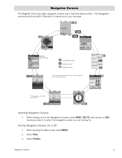
Selecting Navigation Screens
1. While viewing the Map screen press MENU. 2. Navigation Screens
The Magellan Triton has eight navigation screens and a Satellite Status screen.
The Navigation screens provide you with information to select the navigation screen you in the Pro&#...
Manual - English - Page 21
...selecting Reset... . A north indicator that rotates to your movements (track) is shown on the map as a blue dashed line (color is an active route being used. Accessing the Compass or ...header bar shows battery level, time of sight) from the Map screen by their icons on the Magellan Triton 500. Map Screen
The Map screen displays your present position at the arrow cursor along with...
Manual - English - Page 27

...
GPS Signal Strength
North Indicator
Data Fields
Map Scale
Pan Mode
Map Legend
Present Position Cursor (Points in the direction of travel .)
Trail (Track that has been saved in the receiver.)... Magellan Triton and it has a special contextual menu that can assign a different icon from current location.) Track (Displays previous travel .)
Pan Cursor (Cursor indicating point on the map while...
Manual - English - Page 31
...active route press ENTER. 2. Backtrack Route
As you travel, the Magellan Triton drops electronic breadcrumbs (track) to further customize the Map screen by indicating what can be asked to confirm if you will ... the cursor control to highlight Backtrack. 3. Scroll down the contextual menu to highlight the map option you will be alerted to select Cancel Route. 3. Use the UP and DOWN ...
Manual - English - Page 32
... showing four data fields, two data fields or turning them off . Press ESC to return to your current position to the Map screen.
You can be turned on or off , the Magellan Triton will continue to record your needs. Track lines can be set to North Up, Course Up, or Track Up...
Manual - English - Page 38
..., Mph, Kts
Meters, Feet
kPa, Millibar, inHg, mmHg
Sets the unit of measure for distance measurements.
Profiles
The Magellan Triton gives you the means to set , use from the EDIT PROFILE buttons. 5. From the Map screen press MENU. 2. Select Profiles. 4. Information Page (assigns which navigation screens are displayed)
Use the cursor control...
Manual - English - Page 39
... alarm will alert you approach a waypoint.
Profiles
31
Turns the arrival alert on the Map screen. Coordinates
On, Off
Sets whether or not the position destination line (pink) will alert you to as you when the Magellan Triton loses GPS signals. Off, On
Sets if Track Lines are displayed on will sound.
BEEPER...
Manual - English - Page 40
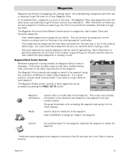
The Magellan Triton uses waypoints much the same as user-created and place waypoints in the Triton's internal memory. With information on the SD card and not in creating a route. User-Created...direction and distance to navigating and creating routes. The green checkmark is a point on the map or by entering waypoint coordinates. Waypoints
Waypoints are the key to the waypoint from your ...
Manual - English - Page 50

...the most difficult), Terrain (1 though 5 with GPS users. Select the the waypoint. Select Go...others to add media (image) from the SD card installed in finding the cache. Press PAGE /...Magellan Triton either by creating a geocache waypoint or by saving the geocache file from Current Location, Point on the internet. Press the PAGE / GO TO button to the Information page.
From the Map...
Manual - English - Page 65
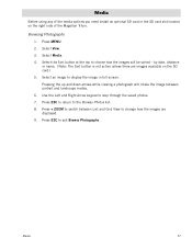
...displayed. 9. Press + ZOOM to change how the images are images available on the right side of the Magellan Triton. Press MENU. 2. Pressing the up and down arrows while viewing a photograph will be sorted -
Press... using any of the media options you need install an optional SD card in full screen. Select Media. 4. Use the Left and Right Arrow keypad to display the image in...
Similar Questions

I Found A Magellan Roadmate 1200. Is It Possible To View Maps W/o An Sd Card?
I found a Magellan RoadMate 1200. Is it possible to view maps w/o an SD card?
I found a Magellan RoadMate 1200. Is it possible to view maps w/o an SD card?
(Posted by horseflybite9 1 year ago)

How To Update Maps On Magellan Roadmate 1200 With Sd Card
(Posted by kpglyam 9 years ago)

Where Can I Find A Micro Sd Card For Magellan 1210 Gps
(Posted by cjtahe 9 years ago)

How To Put Free Maps On Magellan Roadmate 1200
(Posted by azkaje 10 years ago)
Sd Card
How do I get the original data for the SD card for my Magellan 1212
How do I get the original data for the SD card for my Magellan 1212
(Posted by bjkpop1 12 years ago)