Garmin Oregon 650t Support Question
Garmin Oregon 650t Support Question
Find answers below for this question about Garmin Oregon 650t.Need a Garmin Oregon 650t manual? We have 4 online manuals for this item!
Question posted by michaelfeatherstone on October 23rd, 2015
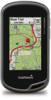
How Do I Get Satellite View Instead Of Topo View On The Map?
The person who posted this question about this Garmin product did not include a detailed explanation. Please use the "Request More Information" button to the right if more details would help you to answer this question.
Current Answers
Related Garmin Oregon 650t Manual Pages
Important Safety and Product Information - Page 2

...• Always be fully aware of California to accept street maps and suggest routes that the mount stays on the windshield. Important...does not obstruct the driver's view of the activity before continuing navigation, and defer to suggest off -road... www.garmin.com/prop65 for outdoor activities. Battery Warnings Your GPS device uses user-replaceable batteries. Ensure that may affect safety...
Important Safety and Product Information - Page 3

...local laws and regulations.
• In addition, the GPS device may cause undesired operation. Operation is subject to ...view the full Declaration of the following two conditions: (1) this device may not cause harmful interference, and (2) this product is prohibitively expensive. FCC Compliance This device complies with all data sources contain some countries, complete and accurate map...
Important Safety and Product Information - Page 2
...interference in compliance with all data sources contain some countries, complete and accurate map information is either not available or is subject to comply with the essential ... interference received, including interference that does not obstruct the driver's view of the FCC Rules. Battery Warnings Your GPS device uses user-replaceable batteries.
These limits are not followed, the...
Owner's Manual - Page 3

...9 Satellite Page 9
Changing the Satellite View 9 Turning Off GPS 9 Simulating a Location 9
Customizing the Device 9 Adjusting the Backlight Brightness 9 Main Menu 9
Customizing the Main Menu 9 Locking the Touchscreen 9 Rotating the Screen 9 Locking the Screen Orientation 9 Creating a Shortcut 9 Adding a Shortcut to the Main Menu 9 Custom Data Fields and Dashboards 9 Enabling the Map...
Owner's Manual - Page 4

...GPS and GLONASS 10 Serial Interface Settings 10 Display Settings 10 Appearance Settings 10 Turning On Scroll Controls 10 Setting the Touchscreen Sensitivity 11 Setting the Device Tones 11 Map Settings 11 Advanced Map... Device 14 Deleting Files 14 Disconnecting the USB Cable 14 Troubleshooting 14 Viewing Device Information 14 Updating the Software 14 Resetting the Device 14 Registering...
Owner's Manual - Page 5
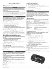
...product warnings and other important information. Installing AA Batteries Instead of the cable into the AC adapter or a
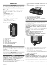
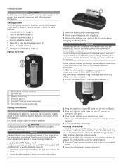
...satellites (page 2). 5 Select to view the status page (page 9). 6 Mark a waypoint (page 2). 7 Navigate to charge a battery that came in the product box for the Oregon...USB port .
À
Á
Camera lens (650 and 650t only)
À
Power key
Á
Battery cover D-ring
...
Owner's Manual - Page 6

.... 4 Move to www.garmin.com / aboutGPS. 1 Hold . 2 Wait while the device locates satellites. Waypoints, Routes, and Tracks
Waypoints
Waypoints are set automatically based on the GPS position. 3 Walk around to record a track (page 3). 4 Select an option: • Select Map to view your track on nearest distance or alphabetical order.
When averaging, the device takes...
Owner's Manual - Page 7
..., go to the beginning of interest, such as BirdsEye satellite imagery, BlueChart® g2, and City Navigator® detailed maps. Where To? For more or less often.
Finding a... Select Next Point. 5 Repeat steps 2-4 to save the route. Viewing a Route on the Map 1 Select Route Planner. 2 Select a route. 3 Select View Map. When paused, the track log is inserted before the point you ...
Owner's Manual - Page 9
... lines. As you are moving in and out of the map. • Select a location on the map (page 3).
3 Complete one or more actions: • Drag the map to view different areas. • Select and to zoom in that point. Navigating with the Oregon 650 and 650t.
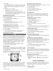
Taking a Photo
1 Select Camera.
5 If you experience irregular compass behavior...
Owner's Manual - Page 10

...2 Select a geocache. 3 Select Go. 4 Navigate using GPS coordinates posted online by those hiding the geocache. You can view photos you have transferred to the device. 1 Select Photo .... • Select On A Specific Date, and enter a date. Viewing the Location of a Photo 1 Select Photo Viewer. 2 Select a photo. 3 Select > View Map. Deleting a Photo 1 Select Photo Viewer. 2 Select a photo....
Owner's Manual - Page 13

...portrait) mode. Opening the Stopwatch
Select Stopwatch.
Simulating a Location 1 Select Satellite > > Use With GPS Off. 2 Select > Set Location On Map. 3 Select a location. 4 Select Use. Main Menu
• ...
• Select Where To?
Changing the Satellite View 1 Select Satellite > . 2 If necessary, select Track Up to orient the satellite view with
your device to the main menu, ...
Owner's Manual - Page 14

...Allows you to GPS, GPS +
GLONASS (page 10), or Demo Mode (GPS off). Screen ...satellite system setting is installed.
Day Color: Sets the color for the selections made when in night mode. For example, the settings and views are saved automatically as data fields or units of measurement, the changes are different when you use a Garmin proprietary format to change the map...
Owner's Manual - Page 15

...log. Activities can be viewed on . Route Transitions: Sets how the device routes from an electronic compass to a GPS compass when you to ...GPS signals acquired. Vehicle: Sets the position icon, which map items will not appear when the map zoom level is drawn. The map items will
appear. Auto Start: Starts recording a track automatically when the device has acquired satellites...
Owner's Manual - Page 16

... a
specific distance.
Marine Settings
Select Setup > Marine. Fishing (requires marine maps) displays a detailed view of a specific depth. Marine Alarm Setup: Sets alarms for many years ... Default Values for comparing your GPS position.
Restoring All Default Settings You can reset trip data, delete all settings back to Garmin Connect.
Map Spheroid: Shows the coordinate system...
Owner's Manual - Page 17
...• Use battery save mode (page 13). • Decrease the map drawing speed (page 11). • Exit the camera application when you...The display turns off when the backlight times out. File Types The handheld device supports these file types: • Files from power. 4... 3 In the battery compartment, slide the card holder to view the status page. Installing a Memory Card You can cause ...
Owner's Manual - Page 18
...computer using the USB cable. 2 Go to avoid data loss.
Before you can view the unit ID, software version, and license agreement. Registering Your Device Help us better... BirdsEye satellite imagery, BlueChart g2, and City Navigator detailed maps. You can use additional maps with the device, such as mounted volumes on -screen instructions.
Troubleshooting
Viewing Device Information...
Owner's Manual - Page 19
...ratio of ascent for the current activity. GPS Signal Strength: The strength of maximum heart rate. Heart Rate Percent Max: The percentage of the GPS satellite signal. Lap Ascent: The vertical distance ...user profile, maximum heart rate, and resting heart rate. You must be viewed as a planned or set route. GPS Elevation: The altitude of day you start the timer and run for 10...
Owner's Manual - Page 21

... restoring, settings 12 routes 3
creating 3 deleting 3 editing 3 settings 11 viewing on the map 3 running 7
S satellite signals 2, 9 screen 9
locking 9 orientation 9
settings 10-12 device 11...12 flashlight 8
Index
G Garmin Connect, storing data 7 geocaches 6, 7, 13
downloading 6 settings 12 GLONASS 10 GPS 9, 10 signal 2
H heading setting 11 heart rate, zones 7, 8, 16 history 7
sending to computer ...
Quick Start Manual - Page 2
... NiMH battery pack (650 and 650t only) or two AA batteries ... Information
WARNING The temperature rating for the Oregon 650 models when using your local waste disposal...lithium batteries.
Installing AA Batteries Instead of the optional NiMH battery... 3 Register the device (page 5). 4 Acquire satellites (page 3). 5 Select to view the status page (page 4). 6 Mark a waypoint...
Quick Start Manual - Page 3

... a Waypoint You can use the Where To?
Not all areas and maps. Turning On the Device
Hold . Where To? The track log contains information about GPS, go to acquire satellite signals. Recording a Track Log Select Current Track > . The device may need a clear view of your changes and close the page. • Select to close...
Similar Questions

How To Acquire Satellites?
The manual tells me to hold the power button. All that does is immediately turn the device off.
The manual tells me to hold the power button. All that does is immediately turn the device off.
(Posted by wfsteele 1 year ago)


I Have The Oregon 650t. Can This Gps Be Used To Calculate Acreage.
(Posted by tlaque8888 10 years ago)

Garmin Rino 650 Shuts Off When I View Map In Track Manager
(Posted by nimastheap 10 years ago)