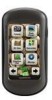
Garmin Oregon 550 Support Question
Garmin Oregon 550 Support Question
Find answers below for this question about Garmin Oregon 550 - Hiking GPS Receiver.Need a Garmin Oregon 550 manual? We have 3 online manuals for this item!
Question posted by ninilda on March 11th, 2014
How To Create Garmin Oregon 550t Tracks
The person who posted this question about this Garmin product did not include a detailed explanation. Please use the "Request More Information" button to the right if more details would help you to answer this question.
Current Answers
Related Garmin Oregon 550 Manual Pages
Owner's Manual - Page 3

...the text indicate that item on the screen, and touch Tracks. button on the screen. For example, if you see ...garmin.com. Introduction
Warning
See the Important Safety and Product Information guide in the product box for using the following products:
• Oregon 450 and 450t • Oregon 550 and 550t
Tips and Shortcuts
• Touch or to scroll and see , "Touch Where To? > Tracks...
Owner's Manual - Page 5

... GPS Satellite
Signals 3 Locking the Screen 3
Basic Navigation 4 Accessing Applications from the
Main menu 4 Creating Waypoints 4 Navigating to a Destination........ 5
Oregon Series Owner's Manual
Table of Contents
Stop Navigating 7 Using the Map 7 Using the Compass 9 Bearing and Course Pointers....11
Managing Waypoints, Routes, and Tracks........... 13 Modifying Waypoints 13 Creating...
Owner's Manual - Page 6

Table of Contents
Monitoring Satellite Reception 22
GPS Games 23 Geocaches 23 Wherigo 23
Customizing the Oregon.. 24 Changing the Profile 24 Setting Up Profiles 24 Using System Setup 25 Customizing the Display.......... 26 Map Setup 26 Tracks Setup 27 Customizing the Main Menu.... 28 Changing the Camera
Settings 29 Changing Marine Settings........ 29...
Owner's Manual - Page 19

...'s Manual 13 Touch Reposition Here.
To edit a waypoint: 1. Touch the waypoint.
3. Managing Waypoints, Routes, and Tracks
5. Touch to delete waypoints.
Touch Waypoint Manager. 2. Touch Delete Waypoint.
Change other attributes, if necessary.
6. NOTE: On the Oregon 550 or 550t, if you have selected a picture for a waypoint and then you want to change the picture. On...
Owner's Manual - Page 20

...: 1.
Touch Route Planner. 2. Editing and Deleting Routes
You can create and store up to edit >
Edit Route. 3.
Touch the route...a different location.
• Review-shows the point on the map.
14
Oregon Series Owner's Manual Touch Route Planner > > to navigate the route. Managing Waypoints, Routes, and Tracks
waypoint, the picture will not be deleted. Touch a category. 3. Touch the...
Owner's Manual - Page 23

...changes are recorded, see page 32.
• Touch Elevation Plot to http://buy.garmin.com for compatible map products.
3D View • Touch 3D View. Go ... The time, the
Oregon Series Owner's Manual 17 Additional Tools
Using the 3D View The Oregon 450t and 550t have a 3D view.
Elevation Plot
The Oregon can be found in some Garmin topographic cartography.
Other Oregon models require DEM ...
Owner's Manual - Page 24

...item to send.
6. Touch OK on both units, touch Share Wirelessly.
3. Sharing Information Wirelessly
The Oregon can wirelessly share waypoints, routes, tracks, and geocaches with another wirelessenabled Garmin recreational device.
1. On the receiving unit, touch Receive. The receiving unit indicates when it is complete.
8. Touch Elevation Plot > one of options. Both units indicate that...
Owner's Manual - Page 26

... Garmin drive (page 39). Viewing Images
The Oregon can load them directly to the Oregon. You can display pictures stored on the Oregon or on -screen directions to your computer using the USB cable. Touch or to calculate.
3.
On the Main menu, touch Photo Viewer.
3.
Touch the picture. 3. Touch the picture. 3. Connect your Oregon 550 or 550t...
Owner's Manual - Page 29

... go") is a type of geocache sites to a geocache using GPS coordinates posted on page 9. A colored line indicates your Oregon to guide you interact with virtual objects and characters.
GPS Games
Geocaches
Geocaching is a toolset for creating and playing GPS-enabled adventures in from www.garmin.com/geocache.
Oregon Series Owner's Manual 23
Use the compass to navigate...
Owner's Manual - Page 31

...: Touch Setup > Profiles > . This profile is a copy of location and velocity information.
• RTCM -receive differential corrections from a RTCM beacon. GPS-select Normal, WAAS (Wide Area Augmentation System), or Demo Mode (GPS off). Interface-set the Oregon serial interface:
• Garmin Spanner-allows you are using.
For information about WAAS, go to provide PVT protocol...
Owner's Manual - Page 32
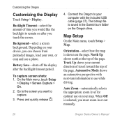
... zoom in the Garmin\scrn folder on your own, or crop and use while driving. Track Up shows your computer with next-turn information to capture. 3.
Orientation-select how the map is selected, you touch the screen. When Off is shown on after the backlight timeout period. Connect the Oregon to remain on...
Owner's Manual - Page 33
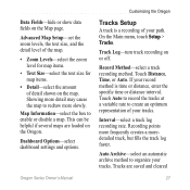
... the Oregon. Map Information-select the box to organize your tracks. Interval-select a track log recording rate.
Data Fields-hide or show data fields on or off. Track Log-turn track recording on the Map page. Showing more detail may cause the map to create an optimum representation of your tracks. Touch Auto to record the tracks at...
Owner's Manual - Page 42

...track satellites in extreme Northern and Southern latitudes)* Resolution: 1 degree
Altimeter: Accuracy: ± 10 ft. (± 3 m)* Resolution: 1 ft. (.3 m) Range: from -610 to 9144 m)
*Subject to proper user calibration. Appendix
Interfaces: Garmin...5 degrees in Demo mode.
36
Oregon Series Owner's Manual Using Demo Mode
Demo mode turns the GPS receiver off for use indoors or for practice....
Owner's Manual - Page 43

... computer using Demo mode because the GPS receiver is located beneath the AA batteries.
Connect the other end of the Oregon.
2.
Lift the metal cover.
3. To connect your Oregon to your computer. Oregon Series Owner's Manual 37 To turn Demo Mode on the bottom
of the cable to http://buy.garmin.com for compatible map products...
Owner's Manual - Page 44

Replace the batteries and the battery cover. Connect the Oregon to or from MapSource: 1. or Send To Device... Turn the Oregon on your Oregon and computer maps such as images, Wherigo cartridges, geocaches, routes, waypoints, and custom POIs. Click Receive From Device...
To transfer tracks, routes, or waypoints to and from a Web site directly to store...
Owner's Manual - Page 48

...or re-export the Software to human readable form the Software or any part thereof or create any other applicable country.
You agree not to decompile, disassemble, modify, reverse assemble,... of Garmin and/or its third-party providers.
You further acknowledge that the Software in Garmin and/or its third-party providers. Appendix
Software License Agreement
BY USING THE OREGON, YOU...
Owner's Manual - Page 50

Index
G Garmin serial 25 Garmin spanner 25 geocaches 23 GPS setting 25 grid north 31 guidance method 28
H heart rate monitor 33, 34
I images
viewing 20 interface ... 31 pressure
ambient 32 barometric 32 trending 32 unit of measurement
30 profiles 24
R recent finds 5 record method, tracks 27 registering the Oregon i routes
calculate 28 edit 14 setup 28 view 15
S satellite signals 3 sensors 34 serial...
Owner's Manual - Page 51

... 22
T text out 25 text size, maps 27 timeout, backlight 26 time zone 30 tones 25 tracks
recording 27 setup 27 track up 26 trip computer 21 true north 31
U unlock screen 3
V variable elevation 32
W WAAS 25 waypoint averaging 22 waypoints
creating 4 Wherigo 23 wireless sharing 18
Z zoom 26
Oregon Series Owner's Manual 45
Quick Start Manual - Page 6

... item to which you want to save the route.
7. Touch Go. Touch > Compass.
6.
To create and navigate a new route: 1.
Use the compass to navigate to your destination. Touch Go > > Compass.
5. Touch to navigate.
4. Touch Setup > Tracks > Track
Log.
Oregon Series Quick Start Manual Touch Map.
2. Touch the first item on the map.
3. Touch a category...
Quick Start Manual - Page 7
...track. Oregon Series Quick Start Manual
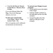
To connect your Oregon to a USB port on the Map page indicates your computer: 1. If you select Record, Show On Map, a line on your current track: Touch Setup > Reset > Clear Current Track... > Yes.
2.
Connect the other end of the Oregon.
2. To clear your computer...
Similar Questions

Create A New Track?
Hello I have a Garmin Montana 650T and am trying to use it to measure haul roads in mining. I have a...
Hello I have a Garmin Montana 650T and am trying to use it to measure haul roads in mining. I have a...
(Posted by regogui 9 years ago)

How To Put Micro Sd Card In Garmin Oregon 550
(Posted by jandcadiy 10 years ago)

Garmin Oregon 550 Does Not Turn On
(Posted by Hondamomma 10 years ago)
How Do I Delete The Recent Find List From The Where To Screen On The Oregon 550
(Posted by enewt 11 years ago)

Will A Dc30 Work On The Astro 320
garmin dc30 collar.will it track on astro 320 handheld.
garmin dc30 collar.will it track on astro 320 handheld.
(Posted by Anonymous-44128 12 years ago)