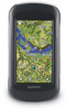
Garmin Montana 650t Support Question
Garmin Montana 650t Support Question
Find answers below for this question about Garmin Montana 650t.Need a Garmin Montana 650t manual? We have 4 online manuals for this item!
Question posted by rgfreedline on July 15th, 2012
Find Current Declination
How can you calculate the current declination between magnetic and grid
Current Answers
Related Garmin Montana 650t Manual Pages
Owner's Manual - Page 1
montana™ 600 series
owner's manual
for use with models 600, 650, 650t
Owner's Manual - Page 2
... rights reserved. ANT™, ANT+™, BaseCamp™, chirp™, HomePort™, and Montana™ are trademarks of Garmin Ltd.
Model: 01102524 or its subsidiaries, registered in the ... United States and/or other countries. Garmin reserves the right to www.garmin.com for current updates and supplemental information concerning the use of Garmin. Go to change or improve its...
Owner's Manual - Page 5
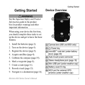
...Safety and Product Information guide in the product box for external GPS
antenna (under weather cap) ➐ Battery cover D-ring...10126; ➐➏
➑
➊ Camera lens (650 and 650t only) ➋ Power key ➌ microSD™ card slot (under... jack (page 18) ➏ Mini-USB port (under weather cap)
Montana 600 Series Owner's Manual
1 Turn on the device (page 4).
3....
Owner's Manual - Page 8
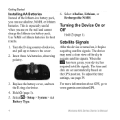
...a clear view of the lithium-ion battery pack, you are set automatically based on the GPS position.
This is turned on the trail and cannot charge the lithium-ion battery pack. ... Rechargeable NiMH. Turn the D-ring counter-clockwise, and pull up to www.garmin.com/aboutGPS.
4
Montana 600 Series Owner's Manual When the
bars turn the D-ring clockwise.
4. Hold (page 1). 5.
...
Owner's Manual - Page 9
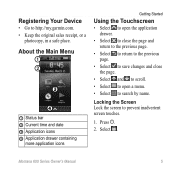
... Select . Press .
2.
About the Main Menu
➊ ➋
➌
➍
➊ Status bar ➋ Current time and date ➌ Application icons ➍ Application drawer containing
more application icons
Getting Started
Using the Touchscreen
• Select ...com. • Keep the original sales receipt, or a
photocopy, in a safe place. Montana 600 Series Owner's Manual
5
Owner's Manual - Page 12
Select an item to the waypoint, and select Save. Select > Waypoint Manager. 2. Select > Delete.
8
Montana 600 Series Owner's Manual Select an option:
• To save your current location as a waypoint.
1. Select Where To? > Waypoints. 2.
Select . Waypoints, Routes, and Tracks
Waypoints, Routes, and Tracks
Waypoints
Waypoints are locations you can save the waypoint ...
Owner's Manual - Page 18
.... 2.
Select OK.
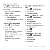
Select a track. 3. Select > Track Manager. 2. Waypoints, Routes, and Tracks
Saving the Current Track The track being recorded is listed. Select a track. 3. Select > Track Manager.
2. Information about the track is called the...4. Select the information bar on a Track 1. Select . 7. Select Set Color. 4. Select a color.
14
Montana 600 Series Owner's Manual
Owner's Manual - Page 19
... > Reset > Clear Current Track > Yes.
Reviewing and Editing an Adventure 1. Select Delete > Yes.
Select an item.
4. Select Archive. Deleting a Track 1. You can archive saved tracks to create and manage your latest hiking trip.
Select an adventure.
3. Archiving a Saved Track You can use BaseCamp to save memory space. 1. Select a track. 3. Montana 600 Series...
Owner's Manual - Page 20
...17) or compass (page 19).
Select > Man Overboard > Start.
16
Montana 600 Series Owner's Manual Navigate using the map or compass.
1. Navigating to a...(page 17) or compass (page 19). The map page opens with a magenta line. 5. Select > Track Manager > Current Track > View Map.
2. Navigation
Navigation
You can save a man overboard (MOB) location, and automatically start navigation back to...
Owner's Manual - Page 23
...of the compass, and continue moving in an auto mount, the compass displays GPS heading, not magnetic heading.
Navigating with the Bearing Pointer When navigating to a destination, the bearing... the destination.
Note: When the device is in that influence magnetic fields, such as cars, buildings, or overhead power lines.
Montana 600 Series Owner's Manual
19 You can use a bearing ...
Owner's Manual - Page 25
Navigation
Resetting the Elevation Plot Select > Elevation Plot > > Reset > Clear Current Track > Yes. Calibrating the Barometric Altimeter You can change the elevation plot to a location where the elevation or barometric pressure is known.
2. Montana 600 Series Owner's Manual
21 Select > Elevation Plot.
Follow the on the plot.
Viewing Details about the point appear...
Owner's Manual - Page 27
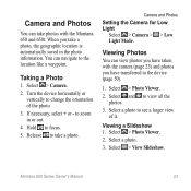
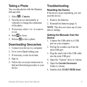
... Select > View Slideshow. Select > Camera.
2. If necessary, select + or -
Select and to focus.
5.
Montana 600 Series Owner's Manual
23 Taking a Photo
1. Select a photo to see a larger view of the photo.
...take photos with the camera (page 23) and photos you have taken with the Montana 650 and 650t.
to the device (page 50).
1. Release to change the orientation of it. ...
Owner's Manual - Page 35
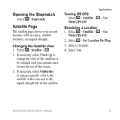
Satellite Page
The satellite page shows your current track toward the top of that satellite.
Select a location.
4. Select Use.
Applications
> Use
Simulating a Location 1. Select > Satellite > > Use
With GPS Off.
2. Montana 600 Series Owner's Manual
31 Changing the Satellite View 1.
Opening the Stopwatch
Select > Stopwatch. Select > Set Location On Map.
3. If necessary, ...
Owner's Manual - Page 58
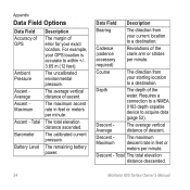
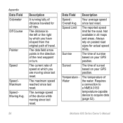
...current pressure. Course
The direction from your starting location to a destination. Descent Maximum
The maximum descent rate in feet or meters per minute. Total The total elevation distance descended.
54
Montana...
Bearing
The direction from your current location to a destination.
Total
Barometer
Description
The margin of GPS
Ambient Pressure
Ascent Average Ascent Maximum...
Owner's Manual - Page 59
...the selected settings.
Appendix
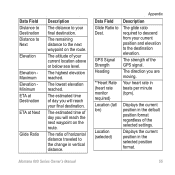
Data Field Glide Ratio to Dest.
Montana 600 Series Owner's Manual
55
Displays the current position in the selected position format. The estimated time of your...reach your current location above or below sea level.
Your heart rate in vertical distance. The altitude of day you are moving. The estimated time of the GPS signal. GPS Signal Strength...
Owner's Manual - Page 60
....
Sunrise
The time of sunset based on posted road signs for actual speed limits. The current rate of speed at which you are moving since last reset.
since last reset.
The ...and areas. Always rely on your GPS position. The temperature of the device while moving since last reset. The distance to acquire data
(page 52).
56
Montana 600 Series Owner's Manual Temperature - ...
Owner's Manual - Page 68
Index
system settings 34 turning off GPS 31 saving tracks 14 screen buttons 5-6 orient 6 sharing...,
56 zone 39 timer 30 tones 37 Trackback 16 tracks 13-15 archiving 15 clearing current 15 deleting 15 profiles 14 recording 13, 38 saving 14 setup 38 viewing 14 track up...8 deleting 8 editing 8 navigating to 16 projecting 9 Where To? 10
Z zoom 37
Montana 600 Series Owner's Manual
Quick Start Manual - Page 1

montana™ 600 series
quick start manual
for use with models 600, 650, 650t
Montana 600 Series Quick Start Manual
1
Quick Start Manual - Page 2
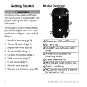
...See the Important Safety and Product Information guide in the product box for external GPS antenna
(under weather cap)
2
Montana 600 Series Quick Start Manual Calibrate the compass (page 6).
6. Record a track...10124;
➍
➎ ➐➏
➑
➊ Camera lens (650 and 650t only)
➋ Power key ➌ microSD™ card slot (under battery
door) ➍...
Quick Start Manual - Page 11
...click START HERE.html. Release to www.OpenCaching.com. 3. Go to take photos with the Montana 650 and 650t.
1. Troubleshooting
Resetting the Device If the device stops responding, you can take a photo. ...port on your device to zoom in . 5. Connect the USB cable to your data or settings. Montana 600 Series Quick Start Manual
11 Select > Camera. 2. Sign in or out. 4.
Plug the...
Similar Questions

How Do I Put The Gps Co-ordinates On To Photo On My Montana 650t
(Posted by Anonymous-152872 8 years ago)


Garmin Edge 500 Wont Go Into Mass Storage Mode
(Posted by Peser 9 years ago)

How To Install The G2 Bluechart On Garmin 650t Montana Gps
(Posted by Xtraaramb 10 years ago)

What Is Horizontal And Vertical Accuracy Of A Garmin Montana 650t Gps
(Posted by morfkm 10 years ago)