Garmin GPSMAP 78sc Support Question
Garmin GPSMAP 78sc Support Question
Find answers below for this question about Garmin GPSMAP 78sc.Need a Garmin GPSMAP 78sc manual? We have 3 online manuals for this item!
Question posted by hamilf on September 22nd, 2011
How Do U Put In Codinates
The person who posted this question about this Garmin product did not include a detailed explanation. Please use the "Request More Information" button to the right if more details would help you to answer this question.
Current Answers
Related Garmin GPSMAP 78sc Manual Pages
Owner's Manual - Page 1
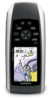
GPSMAP® 78 series
owner's manual
for use with the GPSMAP 78, GPSMAP 78S, and GPSMAP 78Sc
Owner's Manual - Page 6

Getting Started
Device Overview
Internal antenna
Buttons
Display
2
MCX connector for external GPS antenna (under weather cap)
Serial port (under weather cap)
mini-USB port (under weather cap)
Battery compartment
microSD™ card slot (under batteries)
GPSMAP 78 Series Owner's Manual
Owner's Manual - Page 8

...to an open the search menu. Wait while the device searches for
satellites. The GPS bars indicate satellite strength.
Press and hold to that point. A question mark flashes ...backlight status page. Quickly press to store your location. 4. Quickly press to open area. 2. GPSMAP 78 Series Owner's Manual When the bars are green, the device has acquired satellite signals.
...
Owner's Manual - Page 13
...FIND.
2. Select Go. Select a destination. 5. GPSMAP 78 Series Owner's Manual
9 NOTE: Not all map data provides postal code searching.
5.
Finding Marine Services 1. Select Addresses.
3. Select the city.
...garmin.com or contact your Garmin dealer. Enter the city or postal code. Select Marine Services. 3. Additional Maps
To purchase preloaded detailed map data cards, go to search...
Owner's Manual - Page 18
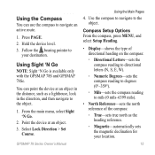
... the top of the compass.
Do not stand near objects that direction until the arrow is available only with the GPSMAP 78S and GPSMAP 78Sc. From the compass, press MENU.
2. When the bearing pointer points toward the top of the electronic compass, you..., the bearing pointer points to enable or disable the maps currently loaded on -screen instructions.
14
GPSMAP 78 Series Owner's Manual
Owner's Manual - Page 19
... route.
1.
Using Sight 'N Go
NOTE: Sight 'N Go is available only with the GPSMAP 78S and GPSMAP 78Sc.
Using the Compass
You can point the device at an object. 3.
You can use ... (0°-359°).
◦◦ Mils-sets the compass reading to
your location.
15 GPSMAP 78 Series Owner's Manual
Using the Main Pages
4. From the main menu, select Sight 'N Go.
2. Select Lock ...
Owner's Manual - Page 20
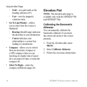
... line leading to a destination.
• Compass-allows you to switch from an electronic compass to a GPS compass when you are traveling at a higher rate of speed for a set period of time, or...Pointer-allows you to select how the course is available only with the GPSMAP 78S and GPSMAP 78Sc. Calibrating the Barometric Altimeter You can manually calibrate the barometric altimeter if you know the ...
Owner's Manual - Page 23
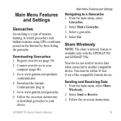
... Find a Geocache. 3. Register your device. Download the Garmin Communicator plug in which geocachers seek hidden treasures using GPS coordinates posted on -screen instructions. Sending and Receiving Data 1.
Main Menu Features and Settings
Geocaches
Geocaching is available only with the GPSMAP 78S and GPSMAP 78Sc.
Select Send or Receive. 3. GPSMAP 78 Series Owner's Manual
19
Owner's Manual - Page 25
This option is displayed in multicolor or single color. GPSMAP 78 Series Owner's Manual
21
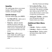
Additional Main Menu Tools
• Calendar-displays a calendar.
• Calculator-displays a calculator.
• Sun and Moon-displays sunrise and sunset times along with your GPS position using the Garmin AutoLocate feature.
Satellite Settings From the satellite page, press...
Owner's Manual - Page 27
...4. Data Field Options
** Available only with the GPSMAP 78S and GPSMAP 78Sc. The average vertical distance of error for your GPS location is accurate to a destination.
The calibrated ...Ascent Average **Ascent Maximum
**Ascent -
Revolutions of the crank arm or strides per minute. GPSMAP 78 Series Owner's Manual
23 For example, your exact location.
The maximum ascent rate in ...
Owner's Manual - Page 28
... of your final destination.
Minimum
Description
The depth of the GPS signal. The total elevation distance descended.
GPS Signal Strength
The strength of the water.
The altitude of... minute (bpm). The maximum descent rate in vertical distance.
required)
24
GPSMAP 78 Series Owner's Manual Customizing Your Device
Data Field Depth
**Descent - Heading
The direction ...
Owner's Manual - Page 29
... format. The current rate of day based on your GPS position. Temperature -
Displays the current position in the direction of sunset based on your GPS position. The distance to acquire data (page 27).
... position in the default position format regardless of travel.
GPSMAP 78 Series Owner's Manual
Customizing Your Device
Data Field
Description
Speed -
Speed -
Owner's Manual - Page 31

... to Normal, WAAS/EGNOS (Wide Area Augmentation System/European Geostationary Navigation Overlay Service), or Demo Mode (GPS off). GPSMAP 78 Series Owner's Manual
27 System Settings
From the main menu, select Setup > System.
• GPS-sets the GPS to accept DGPS Differential Global Positioning System information from a device supplying RTCM data in an SC...
Owner's Manual - Page 32
...nautical chart reflects the drawing scheme of paper charts.
◦◦ Fishing-(requires marine maps) displays a detailed view of bottom contours and depth soundings. Customizing Your ...map presentation for optimal use while fishing.
28
GPSMAP 78 Series Owner's Manual Marine Settings
From the main menu, select Setup > Marine.
• Marine Chart Mode-allows you to take screen captures on...
Owner's Manual - Page 40
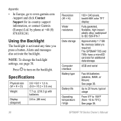
NOTE: To change the backlight settings, see page 38.
The GPSMAP 78S and 78Sc have a microSD card slot for in . (66 mm)
Resolution (W × H) Water resistance
Data storage
... and serial
Two AA batteries (alkaline, NiMH, or lithium) See page 38. Press to 70°C) See page 38.
36
GPSMAP 78 Series Owner's Manual Up to 20 hours, typical usage
From 5°F to 158°F (from -15 to turn on...
Owner's Manual - Page 43
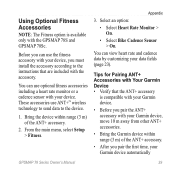
...; Verify that are included with the accessory. Before you can use the fitness accessory with your Garmin device automatically
GPSMAP 78 Series Owner's Manual
39 You can view heart rate and cadence data by customizing your device.
Using Optional Fitness...to send data to the instructions that the ANT+ accessory
is available only with the GPSMAP 78S and GPSMAP 78Sc. Appendix
3.
Owner's Manual - Page 52

... 19 navigating 19 settings 32 GPS signals 4, 21, 23, 24, 37, 45 system settings 27 turning off GPS 21
H HomePort 40 hunting and...marine settings 28-29 MARK button 5 MCX connector 2 measuring area 20 distance 13 MENU button 5, 12, 17, 23 microSD card 36, 39-41 MOB button 4 moonphase 21
N navigating
compass 14 routes 8 to geocaches 19 to waypoints 6 tracks 11
48
GPSMAP...
Quick Start Manual - Page 1

GPSMAP® 78 series
quick start manual
for use with the GPSMAP 78, GPSMAP 78s, and GPSMAP 78sc
Quick Start Manual - Page 7

... after moving long distances, experiencing temperature changes, or changing the batteries.
1.
Select Calibrate Altimeter.
3. note: The three-axis compass is available only with the GPSMAP 78s and GPSMAP 78sc. Select Calibrate Compass > Start.
3. You can manually calibrate the barometric altimeter if you know the correct elevation or the correct pressure.
1. Follow the on...
Quick Start Manual - Page 9

... to the object.
1. Repeat steps 2-5 until the route is available only with the GPSMAP 78s and GPSMAP 78sc. Press FIND. 2.
Use the compass to navigate to save the route. Select a ...contain at least two points. 7.
Creating a Route
1. Select Select Next Point. 6. Navigating a Route
1.
GPSMAP 78 Quick Start Manual
Using Sight 'N Go
NOTE: Sight 'N Go is
complete. Select Use. 5. Select Routes. ...
Similar Questions

How Do I Go Into Simulation Mode On A Garmin Marine Gps Modle741xs
how do I use simulation mode on a garmin 741xs marine ver
how do I use simulation mode on a garmin 741xs marine ver
(Posted by Curthupp 6 years ago)

Not Acquiring Satellite Garmin Gps 78
What do i do if my Garmin GPS 78 does not acquire any sattelites?
What do i do if my Garmin GPS 78 does not acquire any sattelites?
(Posted by vitawyler 7 years ago)


541s Marine Gps. Depth Not Reading Out.
Depth has been working since installed. Now blank. Is there an on off control for this that may have...
Depth has been working since installed. Now blank. Is there an on off control for this that may have...
(Posted by therad50 11 years ago)