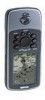
Garmin GPSMAP 76 Support Question
Garmin GPSMAP 76 Support Question
Find answers below for this question about Garmin GPSMAP 76.Need a Garmin GPSMAP 76 manual? We have 2 online manuals for this item!
Question posted by plfelf on May 13th, 2013
Mirror Image
Has anyone else had a GPSMAP 76 suddenly display a miror image. Mine started this recently and I have been unable to find a cure
Current Answers
Related Garmin GPSMAP 76 Manual Pages
Owner's Manual - Page 3
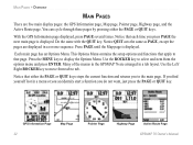
... are also step-by -step directions on and adjust the backlight. The Getting Started chapter provides information such as specifications, optional accessories, and maintenance information. The Main Pages chapter provides detailed explanations about each page in the GPSMAP 76 and step-by -step directions to assist you in the Appendix.
INTRODUCTION...
Owner's Manual - Page 4

Table of Contents
Introduction i About This Manual i Care Information iv
Getting Started 1 Unit Basics 1 Interface Keys 3
Basic Operation 4 Turning on the GPSMAP 76 4 Adjusting Backlight and Contrast 5 Selecting and Entering Data 5 Simulator Mode 5 Initializing the GPS Receiver 7 Initialization Options 8 Creating a Waypoint 9 New, Mark, and Waypoint Page Options............11 Editing...
Owner's Manual - Page 5
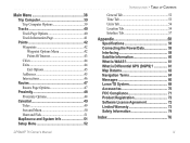
...49 Sun and Moon 50 Hunt and Fish 51 MapSource and System Info 51 Setup Menu 52
GPSMAP 76 Owner's Manual
INTRODUCTION > TABLE OF CONTENTS
General Tab 52 Time Tab 53 Units Tab 54 Location... the Power/Data 59 Interfacing 59 Satellite Information 60 What is WAAS 61 What is Differential GPS (DGPS 61 Map Datums 62 Navigation Terms 64 Messages 66 Loran TD System 68 Accessories 70...
Owner's Manual - Page 9
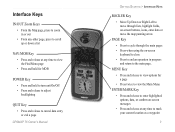
... turn unit On/Off • Press and release to adjust
backlighting
QUIT Key
• Press and release to cancel data entry or exit a page
GPSMAP 76 Owner's Manual
GETTING STARTED > INTERFACE KEYS
ROCKER Key
• Move Up/Down or Right/Left to move through lists, highlight fields, on-screen buttons, icons, enter...
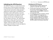
Owner's Manual - Page 10

... signals. To ensure proper initialization, the GPSMAP 76 is now displayed.
To turn off the GPSMAP 76, press and hold the red POWER key. You will now see the Satellite Information page.
3. The GPS Information page is shipped from the factory in AutoLocate mode, which allows the receiver to start initialization, be sure the antenna has a clear...
Owner's Manual - Page 11

..., the instructions will often be directed to be held down for actual navigation. GPS Information Page Menu
GPSMAP 76 Owner's Manual
5 To adjust the backlight/contrast level: 1.
NOTE: Do not try to see the display better. Any Satellite Signal Strength Indicators displayed are only simulations and do not indicate the strength of the highlight is...
Owner's Manual - Page 12

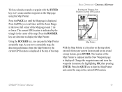
.... Press the ROCKER key RIGHT until the pointer page is displayed.
Using the ROCKER key, highlight Start
Simulator then press the ENTER key. BASIC OPERATION > TURNING ON THE GPSMAP 76
To put the GPSMAP 76 in the Compass Ring indicating the GPS is on track to the destination.
6
GPSMAP 76 Owner's Manual To simulate movement, press PAGE until your...
Owner's Manual - Page 13
... do not use your GPS for several months or move the unit over 600 miles. When the unit is unable to receive enough satellite signals to navigate, it displays an options menu. Follow the screen prompts, pressing PAGE to search for a clear 360° view of the unit tilted upward. GPSMAP 76 Owner's Manual
7 If...
Owner's Manual - Page 14

... and verify the date displayed. When initializing the receiver or trying to receive satellite signals, orient the GPSMAP 76 so the top of the unit pointed toward the sky.
This menu contains the options Automatic or Use Map. BASIC OPERATION > INITIALIZING THE GPS RECEIVER
Initialization Options If the GPSMAP 76 is unable to determine its location, an...
Owner's Manual - Page 19
... Range in the center of the Map Pointer is captured and the New Waypoint page is displayed. Press the ROCKER key any direction to the current GPS location is indicated by highlighting OK, then pressing ENTER.
GPSMAP 76 Owner's Manual
13
The location of the map. Press the IN key several times until the...
Owner's Manual - Page 20

... key until the Pointer is pointing toward your destination (Bearing) while the Compass Ring reflects the direction that while the GPS is now navigating to press or hold the ROCKER key, the speed increases in the GPSMAP 76. This sets a speed of which is displayed. Highlight Go To Point and press ENTER. 3.
Owner's Manual - Page 26
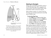
...'s clear the Track Log.
The Track Log is displayed.
GPSMAP 76 Owner's Manual Name this new direction for approximately another two minutes. Highlight TRACKS then press the ENTER key. 3. Continue walking in this waypoint HOME, assign the Residence Symbol, and store the waypoint.
BASIC OPERATION > STARTING TO NAVIGATE
DESTINATION
Current Track 45°
Bearing...
Owner's Manual - Page 27
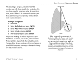
... navigation: 1. Select HOME and press ENTER. 5.
It is displayed alerting you that GPS provides you with the vertical line in the Compass Ring. Select Go To Point and press ENTER. 3.
GPSMAP 76 Owner's Manual
21 With Goto highlighted, press ENTER. BASIC OPERATION > STARTING TO NAVIGATE
DESTINATION
START
When you are near your destination, Arriving at your...
Owner's Manual - Page 28
... acts the same as PAGE, except the pages are displayed in a menu or you accidentaly start a function you press PAGE the next main page is displayed. Press the MENU key to that page.
Many of the menus in the GPSMAP 76 are five main display pages: the GPS Information page, Map page, Pointer page, Highway page...
Owner's Manual - Page 29

...on . The GPS displays your current position but is incapable of providing an altitude reading.
3D GPS Location-indicates the receiver is currently using at least three satellites. GPSMAP 76 Owner's Manual
... and is capable of the GPS receiver always is using three satellite signals. The unit starts in this mode each satellite individually.
The GPS receiver remains in this mode ...
Owner's Manual - Page 30
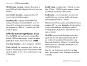
... GPS-indicates the GPSMAP 76 is running in Simulator Mode and the GPS receiver is in the Simulator mode, the Use Map feature allows you have moved the unit over 600 miles and are displayed ...to choose the location from the GPS Information page.
If the unit is turned off. New Elevation-is used if you to simulate.
24
GPSMAP 76 Owner's Manual
Starts or Stops the Simulator. Track Up...
Owner's Manual - Page 31
.... GPSMAP 76 Owner's Manual
25
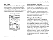
Pressing the IN key decreases the Zoom Range displaying a smaller area with less detail. The current Zoom Range setting is available. MapSource displayed under the range, no further map information is displayed in greater detail or a larger area with greater detail. The standard basemap can access information such as marine navaids...
Owner's Manual - Page 33

Read the description of these settings to locate the different setup items.
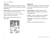
The General, Map, Waypoint, Point, Marine, Line, Area, Topo, City, Road, and Other tabs have setting for an item on the Map page. If you select... a second time.
• Text Setting-allows you select 500 ft as the Zoom Range setting, the selected items are displayed on the Map page. GPSMAP 76 Owner's Manual
27
Owner's Manual - Page 36
... for navaids, tide stations, and services.
Services-include Marinas, Gas Stations, etc.
30
GPSMAP 76 Owner's Manual Points of the options has a Text and Zoom setting.
Navaids-are depth readings... towers, lakes, and parks. Tide Stations-are stations where tide information is gathered. Marine Tab The Marine tab contains text settings for spot sounding and text and zoom settings for the US ...
Owner's Manual - Page 74
... States and the U.S. The GPSMAP unit automatically converts GPS coordinates to using LORAN TD ...mariner, the system is used for "LOng RAnge Navigation." Coastal Confluence Zone. It can display your position as a TD or enter waypoints as TDs. When the unit is placed in the LORAN TD format mode, it will always reference the LORAN chain number and secondary stations
GPSMAP 76...
Similar Questions

How Do I Go Into Simulation Mode On A Garmin Marine Gps Modle741xs
how do I use simulation mode on a garmin 741xs marine ver
how do I use simulation mode on a garmin 741xs marine ver
(Posted by Curthupp 6 years ago)


541s Marine Gps. Depth Not Reading Out.
Depth has been working since installed. Now blank. Is there an on off control for this that may have...
Depth has been working since installed. Now blank. Is there an on off control for this that may have...
(Posted by therad50 11 years ago)
I Bought A Garmin Golf Gps About 6 Months , Can Not Get A Gps Signal. Why
(Posted by eleanortyeryar12 11 years ago)