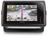
Garmin GPSMAP 741 Support Question
Garmin GPSMAP 741 Support Question
Find answers below for this question about Garmin GPSMAP 741.Need a Garmin GPSMAP 741 manual? We have 7 online manuals for this item!
Question posted by Bayline47 on April 30th, 2014
Connecting Two 741sx Units Together
We have connected two 741sx together with a Garmin Ethernet cable but each unit will not recognize the other. Garmin states that the software version needsrot be updated????
Current Answers
Related Garmin GPSMAP 741 Manual Pages
Flush Mount Kit Instructions (multilingual) - Page 1
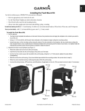
....
• Insert the four hex bolts into place within the unit housing.
• Connect the wiring harness, GPS antenna, and XM antenna (if applicable) to the unit. (This can be done in step 3.)
• When the unit is only a small amount of clearance between the unit housing and the tension mount arms. Cut slightly inside of...
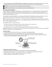
Installation Instructions - Page 3
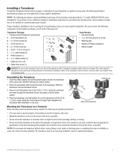
...Garmin dealer. The transducer must be installed by a professional marine installer. Some transducers might be spliced and connected to use a different transducer, installation instructions are provided in the path of the transducer cable... the "s" model GPSMAP 400/500 series chartplotters. On twin-drive boats, mount the transducer between the drives, if possible. GPSMAP 400/500 Series ...
Installation Instructions - Page 5
... without air bubbles, laminates, fillers, or dead air space. • The location must be necessary. Route the transducer cable to the GPSMAP 400/500 series chartplotter using this method. Notice: Avoid routing the cable close to the motor shaft. Place the transducer in the water, pointed directly at all speeds. • The location...
Installation Instructions - Page 8
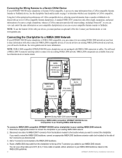
...can receive sonar information from a CANet-compatible Garmin Sounder or Fishfinder device. Connecting the Wiring Harness to a Garmin CANet Device If your local Garmin dealer or marine dealer. NMEA 2000-compatible
GPSMAP 400/500 series
chartplotter
NMEA 2000 device
(not included)
T-connector (not included)
NMEA 2000 device
(not included)
Drop cable (not included)
Existing NMEA 2000 network...
Installation Instructions - Page 10
...occurs.
2.
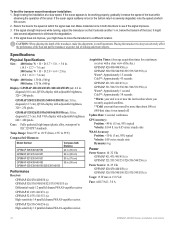
GPSMAP 520/521/530/531/540/541/550/551 (s): 5.0 in .
diagonal (12.7 cm), Full VGA display with adjustable brightness, 320 × 240 pixels.
Update Rate: 1/second, continuous
GPS Accuracy: Position... 45 seconds
GPSMAP 421/431/441/451 (s) GPSMAP 521/526/531/536/541/546/551/556 (s): Warm*: Approximately 1 second Cold**: Approximately 38 seconds
*Warm: your unit is severely ...
Installation Instructions - Page 11
...NMEA 0183, Version 3.01 Sentences: SDDBT, SDDPT, SDMTW, SDVHW, SDWPL
You can purchase complete information about National Marine Electronics Association ...GPSMAP 400/500 series chartplotters are supported by the GPSMAP 525s/526s/535s/536s/545s/546s/555s/556s units... m) (dual beam) - Water Referenced Water Depth Position, Rapid Update COG/SOG Rapid Update GNSS - Dual Beam, 400 W (RMS), 3,200 W (peak...
Weather Supplement - Page 3
.... To connect the XM antenna and receiver and for subscription instructions, refer to the instructions for your chartplotter to a cellular antenna, refer to www.garmin.com/support and click Contact Support
for the following products:
GPSMAP® 431 GPSMAP 531 GPSMAP 541
GPSMAP 431s GPSMAP 531s GPSMAP 541s
GPSMAP 441 GPSMAP 536 GPSMAP 546
GPSMAP 441s GPSMAP 536s GPSMAP 546s
Introduction...
Weather Supplement - Page 12

... generally associated with areas of stronger winds.
➋
➊
Pressure units are generally associated with clouds and the chance of Mercury (inHg), or hectopascals (hPa). From the Home screen, select Information > Weather > Sea Conditions.
2. Isobars ➊ connect points of the water.
8
GPSMAP 400/500 Series Weather Supplement Isobars packed closely together show a strong...
Weather Supplement - Page 22

... or connected with the use the software embedded in this product. Under 10 U.S.C. 456, no warranty, express or implied, including, but not limited to any derivative works based on the basis of the content of a navigational aid prepared or disseminated by the National Geospatial-Intelligence Agency, or the United States Department of the product.
c.
Garmin...
Owner's Manual - Page 3
... Turning the Unit On or Off: page 2. • Acquiring GPS Satellite Signals: ...page 5. • Inserting and Removing SD Cards: page 6. • Restoring the Original Factory Settings: page 6. • Using the Navigation Chart: page 8. • Changing the Navigation Chart Settings: page 11. • Navigating to www.garmin.com/aboutGarmin/environment/disposal.
GPSMAP...
Owner's Manual - Page 4
... iv Contact Garmin iv
Device Overview 1 Front Panel 1 Rear Panel 1 Turning the Unit On or Off 2 Initializing Unit Settings 3 Adjusting the Backlight 4 Using the Keypad 5 Acquiring GPS Satellite Signals ... Using the Split Navigation Chart 13
ii
Using Perspective 3D 13 Using Mariner's Eye 3D 15 Using Fish Eye 3D 16 Using Fishing Charts 17 ...60
GPSMAP 400/500 Series Owner's Manual
Owner's Manual - Page 12
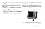
...card to transfer waypoints from the chartplotter. Device Overview
Viewing System Information
You can view the software version, the basemap version, supplemental map information (if applicable), and the unit ID number for
Software Updates, or check the Garmin Web site at www.garmin.com.
6
GPSMAP 400/500 Series Owner's Manual From the Home screen, select Configure > System > System Information...
Owner's Manual - Page 13

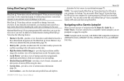
...page 54). Note: You must have an "s" series unit (such as a GPSMAP 441s) with a connected transducer to use a BlueChart g2 Vision SD card. GPSMAP 400/500 Series Owner's Manual
Device Overview 7 ..., Perspective 3D, Mariner's Eye 3D,
Fish Eye 3D, and Split Navigation charts. See the GPSMAP 400/500 Series Weather Supplement for more information. • Configure-access unit and system settings...
Owner's Manual - Page 18

... the boat in the direction of navigation is connected to a compatible marine wind sensor.
➋
Orientation-changes the perspective...wind direction or apparent wind direction ➋ displays if the unit is always up and displays various weather parameters, including precipitation (... right on the screen if shown. See the GPSMAP 400/500 Series Weather Supplement for more information. The...
Owner's Manual - Page 35
..., GPSMAP 536/536s, GPSMAP 541/541s, and GPSMAP 546/546s). determine the best course to your unit.
In low-humidity environments, you are connected to a compatible Garmin autopilot, you start any type of the land and water on a large metal object before handling the card to prevent damage to the card. In addition to detailed marine charting...
Owner's Manual - Page 45

...User Data to transfer data between all the chartplotters connected to a computer.
5. GPSMAP 400/500 Series Owner's Manual
39 To copy the built-in maps to a NMEA 2000 network. Connect the unit to an SD card: 1. Unique data is... the list.
• Select Add New File to the GPSMAP 400/500
Installation Instructions. From Windows® Explorer, open the Garmin\UserData folder on the computer.
Owner's Manual - Page 46
...GPS heading, the time that are equipped with a transponder, and that has elapsed since the last position of the vessel. The DSC List shows the mostrecent call in the
Garmin... your chartplotter: 1.
Note: To view information about other boats, your unit must be connected to an external AIS (Automatic Identification System) or DSC (Digital Selective ...GPSMAP 400/500 Series Owner's Manual
Owner's Manual - Page 67

...Call with the radio to change the line color.
For example, if you connect your Garmin VHF Radio Owner's Manual. DSC Call Information). If your chartplotter configured to ....
2.
This option is connected to a Garmin NMEA 2000-compatible radio and you are displayed. From a chart screen, press MENU > Other Vessels > DSC >
DSC Trails.
2.
GPSMAP 400/500 Series Owner's Manual...
Owner's Manual - Page 68
...symbol.
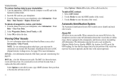
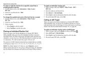
• Select Trail Line to the radio. 5. Placing an Individual Routine Call
When you connect your chartplotter, you can select one of the following channels on selecting a channel other than the default... routine call . On your Garmin chartplotter to a Garmin VHF NMEA 2000-compatible radio, you connect your Garmin VHF radio, select Call.
62
GPSMAP 400/500 Series Owner's Manual
Owner's Manual - Page 76
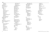
...48 fish eye 3D 16 initializing 3 language 47 navigation preferences 47 system 46 units of measure 46 shoreline distance 47 simulator 46 mode 5 skyview 46 software license agreement 67 software version 46 sonar advanced settings 57 appearance 57 cone 16 full screen 54 scroll ...gauge 35 close hauled 36 Z zoom 58 2x 58 4x 58 manual 58 split 58
GPSMAP 400/500 Series Owner's Manual
Similar Questions

How Do I Go Into Simulation Mode On A Garmin Marine Gps Modle741xs
how do I use simulation mode on a garmin 741xs marine ver
how do I use simulation mode on a garmin 741xs marine ver
(Posted by Curthupp 6 years ago)

Do All 4 Wires Need To Be Connected?
do all 4 wires need connected. Not interested in sharing data.
do all 4 wires need connected. Not interested in sharing data.
(Posted by Zekerondog1 6 years ago)

I Need A Owner Manual In Spanish Version Of Gpsmap 741s
(Posted by lastracardoso17 9 years ago)

541s Marine Gps. Depth Not Reading Out.
Depth has been working since installed. Now blank. Is there an on off control for this that may have...
Depth has been working since installed. Now blank. Is there an on off control for this that may have...
(Posted by therad50 11 years ago)