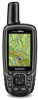
Garmin GPSMAP 64st Support Question
Garmin GPSMAP 64st Support Question
Find answers below for this question about Garmin GPSMAP 64st.Need a Garmin GPSMAP 64st manual? We have 4 online manuals for this item!
Question posted by dlinder on March 4th, 2016
Upload Of Waypoints
Can I upload waypoints from a shapefile or other format to the unit
Current Answers
Answer #1: Posted by TommyKervz on March 5th, 2016 12:43 AM
TommyKervz

Member since:
January 10th, 2013 Points: 17,776,843

Member since:
January 10th, 2013 Points: 17,776,843
See page 9 and 10 of the owners manual here https://www.helpowl.com/manuals/Garmin/GPSMAP64st/216706
Related Garmin GPSMAP 64st Manual Pages
Important Safety and Product Information - Page 3

...8226; Only replace the battery with applicable local laws and regulations.
• In addition, the GPS device may be incurred as the real-time clock.
This equipment generates, uses, and can be... and accurate map information is either not available or is on a different circuit from the GPS device.
• Consult the dealer or an experienced radio/TV technician for various purposes,...
Declaration of Conformity - Page 1
...Electromagnetic compatibility and Radio spectrum Matters (ERM); Limits and methods of Equipment:
Information Technology Equipment (Global Positioning System Receiver)
Model Number(s):
GPSMAP 64 GPSMAP 64s GPSMAP 64st
The undersigned does hereby declare that the equipment complies with the above Directives
Jamie Wiltshire Quality Supervisor Garmin (Europe) Ltd. ElectroMagnetic Compatibility...
Owner's Manual - Page 1
GPSMAP® 64
Owner's Manual
February 2014
190-01702-00_0B
Printed in Taiwan
Owner's Manual - Page 2

...of SD-3C, LLC. Windows® is under license. Garmin®, the Garmin logo, City Navigator®, and GPSMAP® are trademarks of such changes or improvements. These trademarks may not be used without obligation to www.garmin.com for... Garmin is a registered trademark of Garmin Ltd. or its subsidiaries, registered in the United States and other countries. All rights reserved.
Owner's Manual - Page 3
... Satellite Signals 2 Keys 2
Waypoints, Routes, and Tracks 2 Waypoints 2
Creating a Waypoint 2 Projecting a Waypoint 2 Navigating to a Waypoint 2 Editing a Waypoint 2 Deleting a Waypoint 2 Routes 2 Creating a... 9
Adding a Page 9 Removing a Page 9 Changing the Units of Measure 9 Time Settings 9 Position Format Settings 9 Altimeter Settings 9 Routing Settings 9 Profiles 9 Creating ...
Owner's Manual - Page 5

...computer. 1 Pull up to 50°C). Battery Information
WARNING The temperature rating for GPS antenna (under weather cap) Å microSD™ card slot (under weather ... two AA batteries, observing polarity. Installing Batteries
The handheld device operates using a standard wall outlet or a USB port on GPSMAP 64s and GPSMAP 64st models only.
3 Insert the battery pack, observing polarity...
Owner's Manual - Page 6
.... shows the GPS/GLONASS signal strength.
Select to open .
A question mark flashes while the device determines your current location as a waypoint. 1 Select ...Waypoint Manager. 2 Select a waypoint. 3 Select MENU > Project Waypoint. 4 Enter the bearing, and select Done. 5 Select a unit of waypoints or locations that is inserted before the point you to edit, such as a waypoint...
Owner's Manual - Page 7
...: Adjusts how the map is a recording of your current direction of the track line on the map. Tracks are navigating to setup screens including waypoints, tracks, and routes.
Waypoint names and symbols appear on the map. Deleting a Route 1 Select Route Planner. 2 Select a route. 3 Select Delete Route.
Reversing a Route 1 Select Route Planner. 2 Select...
Owner's Manual - Page 8

...course.
You can use on the map. Compass
When navigating, points to a GPS compass when you change profiles (Profiles).
Trip Computer
The trip computer displays your...is higher than the selected level.
Change Dashboard: Changes the theme and information
displayed on the GPSMAP 64s and GPSMAP 64st. 1 Select Sight 'N Go. 2 Point the device at an object. 3 Select Lock...
Owner's Manual - Page 9

...NOTE: The barometric altimeter is available only on the GPSMAP 64s and GPSMAP 64st. 1 Go to a location where the elevation or...2 Select MENU > Restore Defaults.
Delete All Waypoints: Deletes all trip data. Calibrating the Barometric ...to your current location, GPS accuracy, satellite locations, and signal strength.
You can go to www.opencaching.com to upload your device to find...
Owner's Manual - Page 10

... your live data on your VIRB camera. You can create an adventure for your GPSMAP 64s or GPSMAP 64st. Activity uploads to Garmin Connect: Automatically sends your activity to Garmin Connect as soon as an ... card appear as a second removable drive. Waypoint Averaging
You can create an adventure and send it to My
Collection or to turn the GPS on your compatible smartphone, enter the passkey....
Owner's Manual - Page 11
...local time of day when you will reach the next waypoint on GPS. ETA At Next: The estimated time of the waypoint). GPS Heading: The direction you are not currently
using the device...Heading: The direction you are received. Elevation Above Ground: The altitude of the selected position format setting. Your device must be connected to a destination. Calendar: Displays a calendar. Last ...
Owner's Manual - Page 12
... connected to the left . You must be navigating for this data to GPS, GPS +
GLONASS , or Demo Mode (GPS off . Satellite System: Sets the satellite system to appear. NOTE: Changing... navigating for this data to use a Garmin proprietary format to appear. Waypoint At Next: The next point on your current location and time settings (format, time zone, daylight saving time). NOTE: This...
Owner's Manual - Page 13

... all pressure data, which represents your GPS position.
Adding a Page 1 From...Save Always records all waypoints, clear the current ...GPSMAP 64s and GPSMAP 64st. Distance routes you to weather. Changing the Units of Measure
You can select PAGE to add. Select Setup > Routing. Marine Alarm Setup: Sets alarms for the type of settings that specifies a different position format...
Owner's Manual - Page 17
...
ANT + sensors 11 smartphone 6 position format 9 power key 2 product registration 10 profiles... the device 10 updating software 10 geocaches 5, 11 downloading 5 GLONASS 10 GPS 5 satellite page 5 settings 8
H HomePort 11 hunting and fishing times ...U unit ID 10 units of measure 9 USB 8
connector 1 disconnecting 12 mass storage mode 11 transferring files 11 user data, deleting 12
W WAAS 8 waypoints ...
Quick Start Manual - Page 1

GPSMAP® 64
Quick Start Manual
February 2014
190-01702-01_0B
Printed in Taiwan
Quick Start Manual - Page 2
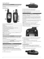
...handheld device operates using a standard wall outlet or a USB port on your local waste disposal department to a power source, the device turns on GPSMAP 64s and GPSMAP 64st models only. Device Overview
À Internal GPS... the device to properly recycle the batteries.
Use NiMH or lithium batteries for GPS antenna (under weather cap) Å microSD™ card slot (under batteries...
Quick Start Manual - Page 3

.... 6 Select QUIT to select options and acknowledge messages. Navigating a Saved Route Before you can edit a waypoint, you must save the route.
Waypoint names and symbols appear on the map. Turning On the Device Hold . shows the GPS/GLONASS signal strength. Keys
FIND MARK QUIT ENTER MENU
PAGE
IN OUT
Select to edit, such...
Quick Start Manual - Page 4

...remove user-replaceable batteries. NOTE: The barometric altimeter is available only on the GPSMAP 64s and GPSMAP 64st. 1 Go to a location where the elevation or barometric pressure
is available ...The device has a 3-axis electronic compass (GPSMAP 64s and GPSMAP 64st models only).
Bluetooth® 4. 0 (includes EDR and BLE) 7 in the handheld device for information about this product on -...
Quick Start Manual - Page 6

... 221 985465
+385 1 5508 272 +385 1 5508 271 + 45 4810 5050
+ 358 9 6937 9758
+ 331 55 69 33 99
Garmin®, the Garmin logo, and GPSMAP® are trademarks of Garmin Ltd. or its subsidiaries, registered in the USA and other countries.
Similar Questions

Garmin Edge 500 Wont Go Into Mass Storage Mode
(Posted by Peser 9 years ago)

Upload Waypoints
How do I upload waypoints from my computer to the GPS ?
How do I upload waypoints from my computer to the GPS ?
(Posted by gr2758000 10 years ago)

Uploading Data To Memory Map
I realise now that MM cannot be uploaded to the GPS unit (edge 800) but I should be able to download...
I realise now that MM cannot be uploaded to the GPS unit (edge 800) but I should be able to download...
(Posted by gilllorraine 11 years ago)

Receiving Waypoint In Rino650
I can not recived waypoint on Mapsource from my gps rino 650
I can not recived waypoint on Mapsource from my gps rino 650
(Posted by nawahmad 11 years ago)

Gpsmap 276c With Fishfinder Gsd 21 Does Not Show Watertemperature?!
GPSMAP 276C with Fishfinder GSD 21 working now great, but does not show watertemperature! THX for He...
GPSMAP 276C with Fishfinder GSD 21 working now great, but does not show watertemperature! THX for He...
(Posted by bossino 12 years ago)