Garmin GPSMAP 5012 Support Question
Garmin GPSMAP 5012 Support Question
Find answers below for this question about Garmin GPSMAP 5012 - Marine GPS Receiver.Need a Garmin GPSMAP 5012 manual? We have 9 online manuals for this item!
Question posted by jerico0615 on August 6th, 2012
Water Temperature
is garmin 5012 have water pemperature reading
Current Answers
Related Garmin GPSMAP 5012 Manual Pages
Installation Instructions - Page 1
... options: • Connecting the chartplotter to other Garmin Marine Network compatible devices, such as a sounder or a radar (page 12). • Connecting the chartplotter to an existing NMEA 2000 network (page 10). • Connecting the chartplotter to the GPS antenna (pages 9-10). 4. Note: You cannot bail mount the GPSMAP 5015/5215 chartplotters. Before installing your...
Installation Instructions - Page 5
... under fiberglass. See page 7.
• Connects to water level. OD pipe-threaded-pole marine mount (14 threads- OK Radar
3 ft. (1 m) VHF Radio Antenna
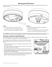
GPS 17x Placement Considerations
GPSMAP 4000/5000 Series Installation Instructions
Choosing a Location for the GPS Antenna
You can surface mount the GPS 17 and GPS 17x antennas, attach them to the chartplotter using...
Installation Instructions - Page 12
..., GSD sounder, or GDL XM Weather receiver to any connected GPSMAP 4000/5000 series chartplotter.
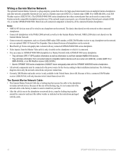
• Video input(s) from connected network compatible Garmin devices such as a Garmin sonar unit (GSD 22), a Garmin radar (GMR 18 or GMR 404/406), or an XM Weather receiver (GDL30/30A). Wiring a Garmin Marine Network
The optional Garmin Marine Network is a plug-and-play system...
Installation Instructions - Page 14
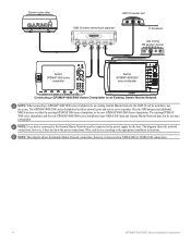
... port expander
xxxxxxxxxxxxxxxxxxxxxxx
To transducer
GDL 30/30A XM weather receiver
Garmin GPSMAP 3000 series
chartplotter
Garmin GPSMAP 4000/5000
series chartplotter
Connecting a GPSMAP 4000/5000 Series Chartplotter to an Existing Garmin Marine Network
Note: When connecting a GPSMAP 4000/5000 series chartplotter to an existing Garmin Marine Network, the GMS 10 can be connected to the power...
Installation Instructions - Page 16
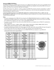
..., GPRMB, GPRTE, GPVTG, GPWPL, GPXTE, and Garmin proprietary sentences-PGRME, PGRMM, and PGRMZ.
• The GPSMAP 4000/5000 series chartplotter also includes support for the WPL sentence, DSC, and sonar NMEA 0183 input with support for the DPT (depth) or DBT, MTW (water temperature), and VHW (water temperature, speed, and heading) sentences.
• Use the...
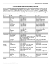
Technical Reference for Garmin NMEA 2000 Products - Page 4
... Display Device PGN Information...13
GPSMAP 4000/5000 Series Chartplotters...13 GMI 10...14
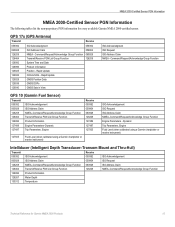
NMEA 2000-Certified Sensor PGN Information...15 GPS 17x (GPS Antenna)...15 GFS 10 (Garmin Fuel Sensor)...15 Intelliducer (Intelligent Depth Transducer-Transom Mount and Thru-Hull)...15 GWS 10 (Garmin Wind Sensor)...16 GHP 10 (Marine Autopilot System)...16
CCU...16...
Technical Reference for Garmin NMEA 2000 Products - Page 13
... Speed Sensor Fuel Level Sensor Fuel Level Sensor Fuel Level Sensor Garmin Chartplotter and GPS Antenna
Garmin Chartplotter and GPS Antenna
Garmin Chartplotter Garmin Chartplotter and GPS Antenna Garmin Chartplotter and GPS Antenna Garmin Chartplotter and GPS Antenna Garmin Chartplotter and GPS Antenna Heading Sensor GPS Antenna
Technical Reference for a list of sensors may provide more about...
Technical Reference for Garmin NMEA 2000 Products - Page 15

... Sensor, a Heading Sensor, and a GPS Antenna
• Wind Sensor and a GPS Antenna • Wind Sensor and a Water Speed
Sensor, and a Heading Sensor
Sunrise/Sunset
129026 - Water Speed (If a Water Speed Sensor is not present, a less accurate reading can be calculated using a GPS antenna instead [129026 - Nav Data
Garmin Chartplotter and GPS Antenna
Maximum Apparent Wind Speed 130306...
Technical Reference for Garmin NMEA 2000 Products - Page 19
...
128267 Water Depth
130312 Temperature
Technical Reference for every available Garmin NMEA 2000-certified sensor. Command/Request/Acknowledge Group Function Transmit/Receive PGN ... Garmin chartplotter or marine instrument)
ISO Acknowledgement ISO Request ISO Address Claim NMEA-Command/Request/Acknowledge Group Function Engine Parameters -
GPS 17x (GPS Antenna)
Transmit
Receive
059392...
Technical Reference for Garmin NMEA 2000 Products - Page 23
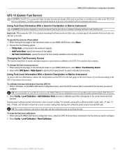
...With a Garmin Chartplotter or Marine Instrument To receive fuel-level information, connect the wiring harness on your boat;
Entering more calibration points will provide a more -accurate reading. Choose ...accurate reading than entering two calibration points (empty tank and full tank). Select either GPS Speed or Water Speed to specify which speed sensor is shown on the GFS 10 for Garmin NMEA...
Owner's Manual - Page 4
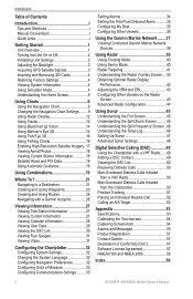
... Initializing Unit Settings 2 Adjusting the Backlight 3 Acquiring GPS Satellite Signals 3 Inserting and Removing SD Cards 4 Restoring...BlueChart g2 Vision 14 Using Mariner's Eye 3D 14 Using...25 Navigating with a Garmin Autopilot 26
Viewing ...the Garmin Marine Network........37 Viewing Connected Garmin Marine ... the DSC List 50 Receiving Distress Calls 50 Man-...Garmin 57 Declaration of Conformity (DoC ...
Owner's Manual - Page 13
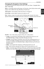
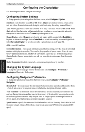
...Water Temperature, and Water Speed data bar on or off. • Fuel-turn the Fuel Rate, Remaining Fuel, Range, and Fuel Economy data bar on or off. • Sailing-turn the GPS Speed, GPS Heading, Depth, and GPS...Bar Setup to configure the position of marine service points on or off .
High...your boat, indicating compass direction.
Data bars
GPSMAP® 4000/5000 Series Owner's Manual
...
Owner's Manual - Page 18
...a view of the interval.
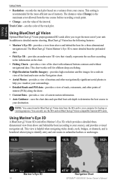
Mariner's Eye 3D 14
Navigation Chart GPSMAP® 4000/5000 Series Owner...Mariner's Eye 3D, which provides a detailed threedimensional view from above and behind the boat (according to get the most -efficient use the SD card on a variance from above and behind the boat for a realistic view of the land and water...Garmin GPS units. This setting is more detailed than the...
Owner's Manual - Page 36
...Up (GPSMAP 4010 and GPSMAP 5015 only)-turn Simulator Mode On or Off. a Garmin Product ...GPSMAP® 4000/5000 Series Owner's Manual
Select the event to brighten or darken the backlight.
Touch Wind or Fuel Economy to retrieve data about the marine network. Select Setup to set simulator options. (If you transition to switch between Water (from a water-speed sensor) and GPS...
Owner's Manual - Page 39
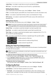
... connected to the Garmin Marine Network to receive sonar information. To enable the Total Fuel Onboard alarm and set an alarm to allow when calculating an auto guidance path. Shallow Water-set an alarm to sound when the depth is greater than one meter is 2°F (1.1°C) above or below the specified temperature. Fish-set...
Owner's Manual - Page 41
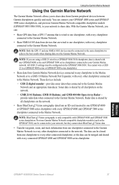
... devices include:
◦ GSD 22 digital sounder-provides sonar data when connected to the Garmin Marine Network. Marine Network
GPSMAP® 4000/5000 Series Owner's Manual
37 NOTE: Both the GPS 17 and any chartplotter in one chartplotter connected to the Garmin Marine Network to every other chartplotter connected to achieve the best results when sharing data...
Owner's Manual - Page 49
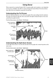
... a full-screen graph of detected objects as a fishfinder. The GSD 22 connects through the Garmin Marine Network and shares sonar data with every chartplotter connected to the network. Depth, temperature, and water speed
Suspended target
Bottom
Range
GPS speed and GPS heading
Transducer frequency
Understanding the Split Zoom Screen
Use the Split Zoom screen to view...
Owner's Manual - Page 50

...left; Depth, temperature, and water speed
GPS speed and GPS heading
Range
Transducer frequencies
Understanding the Temp Log
If you are shown in the upper-left as information is received.
A 200 kHz...46
GPSMAP® 4000/5000 Series Owner's Manual
The current temperature and depth are using a temperature-capable transducer, the Temp Log screen keeps a graphic log of temperature readings ...
Owner's Manual - Page 59
... out of the sky.
Can't Read User Card-cannot read .
Contact Garmin Product Support for deep water. Contact product support. GPSMAP® 4000/5000 Series Owner's Manual
Appendix
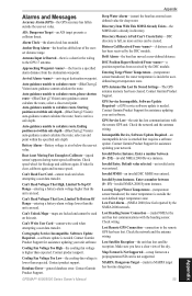
Deep Water Alarm-(sonar) the boat has entered userdefined value for assistance updating your unit software. Distress Call Received From -A distress call has been received by the DSC module.
Contact...
Owner's Manual - Page 63
... 5, 32-36 my boat 35 other boats 36 water speed 36
contact Garmin 57 course up 10 create waypoint 8 creating routes 25...21 GPS satellite signals 3, 32 GSD 22 37 guide to 21
H
Hazard Colors 15 heading 33 Heading Line 10
GPSMAP®...44
M
man overboard 23 map datum 33 MapSource data 28 marine network 37 mariner's eye 6 mariner's eye 3D 14
colors 15 mark current location 23 mark ...
Similar Questions

Master Reset (hard Reset) Gpsmap 5012/5015
How do I "Master Reset" (hard reset) GPSMAP 5012 or 5015? I do not mean the menu selection to reset ...
How do I "Master Reset" (hard reset) GPSMAP 5012 or 5015? I do not mean the menu selection to reset ...
(Posted by ammarmalhas 4 years ago)

How Do I Go Into Simulation Mode On A Garmin Marine Gps Modle741xs
how do I use simulation mode on a garmin 741xs marine ver
how do I use simulation mode on a garmin 741xs marine ver
(Posted by Curthupp 6 years ago)

Water Temperature Not Showing On Gpsmap 431s.
Water temperature was showing when the unit was installed. the unit is removed from the boat during ...
Water temperature was showing when the unit was installed. the unit is removed from the boat during ...
(Posted by tbuckland2 8 years ago)

Incorrect Speed Reading (knots)
Am Not Getting A Correct Speed Reading And I Have Been Into The Settings And Manually Changed And Tr...
Am Not Getting A Correct Speed Reading And I Have Been Into The Settings And Manually Changed And Tr...
(Posted by glenlark 9 years ago)

Position Data Box
I have a Garmin 5012 chartplotter. I am not getting a position display in the data box (lower right ...
I have a Garmin 5012 chartplotter. I am not getting a position display in the data box (lower right ...
(Posted by lenny10162 11 years ago)