Garmin GPSMAP 5012 Support Question
Garmin GPSMAP 5012 Support Question
Find answers below for this question about Garmin GPSMAP 5012 - Marine GPS Receiver.Need a Garmin GPSMAP 5012 manual? We have 9 online manuals for this item!
Question posted by lenny10162 on October 14th, 2012
Position Data Box
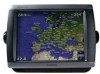
I have a Garmin 5012 chartplotter. I am not getting a position display in the data box (lower right hand corner) Full signal strenght on GPS and also showing satellites tracking. Any help?
Current Answers
Related Garmin GPSMAP 5012 Manual Pages
Installation Instructions - Page 1
... phone at 44/0870.8501241. In Europe, contact Garmin (Europe) Ltd. To install the GPSMAP 4000/5000 series chartplotter, you must : 1. Mount the GPSMAP 4000/5000 series chartplotter (page 1). 2.
The holes on the mounting hardware chosen. GPSMAP® 4000/5000 Series Installation Instructions
The GPSMAP 4000/5000 series chartplotter and GPS antenna must be properly installed according to the...
Installation Instructions - Page 9
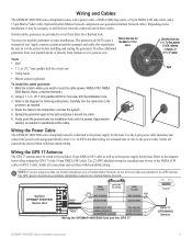
...Marine Video
waterproof seal. Depending on )
Blue (data in . (31.7 mm) paddle drill bit or hole saw , drill the installation hole.
3. Garmin rubber grommets are using more than one Garmin chartplotter over a Garmin Marine... GPSMAP 4000/5000 series chartplotter must be connected to the NMEA 0183
cable or GPS 17 cable. The GPS signal is seated. on)
> Green (Data out)
GREEN/white (data in...
Installation Instructions - Page 10
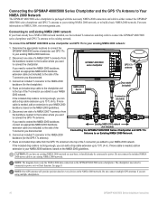
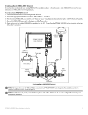
... an Existing NMEA 2000 network If your NMEA 2000 backbone, based on NMEA 2000, visit www.garmin.com. Connecting to power or it will provide position data for the chartplotter).
4. To connect the GPSMAP 4000/5000 series chartplotter and GPS 17x to power. GPSMAP 4000/5000 series chartplotter
GPS 17x antenna
3. If more
information on the NMEA 2000 guidelines. The...
Installation Instructions - Page 11
...shows only the NMEA 2000 data connection to a 12 Vdc power source through a switch. GPSMAP 4000/5000 Series Installation Instructions
11 Creating a Basic NMEA 2000 Network If your boat does not already have an existing NMEA 2000 network installed, you are using multiple chartplotters. Note: One GPS antenna will provide position data... for every device on NMEA 2000, visit www.garmin.com.
Installation Instructions - Page 12
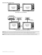
... that can connect a GPSMAP 4000/5000 chartplotter to a Marine Network with a GPSMAP 3000 series chartplotter: • They will share GPS 17 GPS position information as well as a sonar unit (GSD 22), a radar (GMR 18 or GMR 404/406), or an XM Weather receiver (GDL30/30A). • Garmin GPSMAP 3000 series chartplotters CANNOT share cartography data with the cable.
12
GPSMAP 4000/5000 Series...
Installation Instructions - Page 13
...
xxxx
GSD 22 sounder unit
xxxxxxxxxxxxxxxxxxxxxxx
To transducer
Garmin GPSMAP 4000/5000 series
chartplotter
Garmin GPSMAP 4000/5000 series
chartplotter
Extended Marine Network With Two Chartplotters
Note: Every device connected to the Garmin Marine Network must be connected to the appropriate installation instructions.
These diagrams show the power connections. however, they do not...
Installation Instructions - Page 14
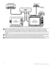
... GPS antenna and additional NMEA devices to the appropriate installation instructions. however, it does not show NMEA 2000 or NMEA 0183 connections.
14
GPSMAP 4000/5000 Series Installation Instructions This diagram shows the network connections; The existing GPSMAP 3000 series chartplotter and the new GPSMAP 4000/5000 series chartplotter share NMEA 0183 data and Garmin Marine Network data...
Installation Instructions - Page 16
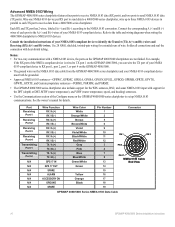
...GPRTE, GPVTG, GPWPL, GPXTE, and Garmin proprietary sentences-PGRME, PGRMM, and PGRMZ.
• The GPSMAP 4000/5000 series chartplotter also includes support for the WPL ...GPS 17 out spare Alarm
Accessory on the GPSMAP 4000/5000 chartplotters are not linked.
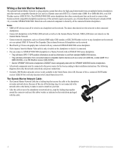
Each RX and TX port has 2 wires, labeled A (+) and B (-) according to receive data from the GPSMAP 4000/5000 series chartplotter...
Installation Instructions - Page 20
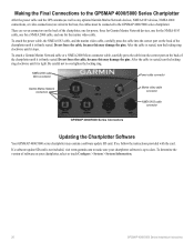
... ring clockwise until it is not included, visit www.garmin.com to -date. Be careful not to the GPSMAP 4000/5000 series chartplotter. Making the Final Connections to the GPSMAP 4000/5000 Series Chartplotter
After the power cable and the GPS antenna (as well as any optional Garmin Marine Network devices, NMEA 0183 devices, NMEA 2000 connections, or...
Installation Instructions - Page 21
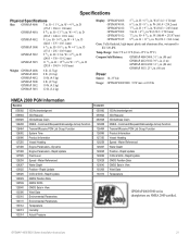
...245.8
mm)
5
in View Wind Data Temperature
GPSMAP 4000/5000 series chartplotters are NMEA 2000 certified. Rapid Update GNSS Position Data GNSS Sats in . D
(176.9 × 284.4 × 106 mm)
GPSMAP 4010:
8
/29 32
in .
Water Referenced Water Depth Position - Rapid Update COG & SOG - W
×
4
/11 64
in . D
(173.5 × 256 × 105.9 mm)
GPSMAP 5012:
9
/15 32
in...
Remote Instructions (Multilingual) - Page 1

... and void your warranty and your chartplotter owner's manual or product information sheet to the following measures:
• Reorient or relocate the receiving antenna. • Increase the separation between the equipment and the receiver. • Connect the equipment into an outlet that any unauthorized commercial distribution of Garmin. Garmin hereby grants permission to download a single...
Technical Reference for Garmin NMEA 2000 Products - Page 3
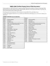
... ◦ GPSMAP® 4/5000 Series chartplotters ◦ ...list of NMEA 2000specific data used with Garmin NMEA 2000-certified displays and sensors.
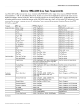
•...Data Type Requirements, provides a table to help you determine which NMEA 2000 sensors provide the particular data type you want.
• The last two sections provide Parameter Group Number (PGN) information for Garmin chartplotters and marine...
Technical Reference for Garmin NMEA 2000 Products - Page 4
... 2000 Data Type Requirements...9
NMEA 2000-Certified Display Device PGN Information...13
GPSMAP 4000/5000 Series Chartplotters...13 GMI 10...14
NMEA 2000-Certified Sensor PGN Information...15 GPS 17x (GPS Antenna)...15 GFS 10 (Garmin Fuel Sensor)...15 Intelliducer (Intelligent Depth Transducer-Transom Mount and Thru-Hull)...15 GWS 10 (Garmin Wind Sensor)...16 GHP 10 (Marine Autopilot...
Technical Reference for Garmin NMEA 2000 Products - Page 13
... and GPS Antenna Garmin Chartplotter and GPS Antenna Heading Sensor GPS Antenna
Technical Reference for a list of sensors may provide more about PGN information, see page 13. For more precise information. COG/SOG and 129029 - Engine Rapid 127488 - Eng Dynamic (GPS Speed or Water Speed) 127505 - Vessel Heading 129026 - Engine Rapid 127489 - Eng Dynamic 127489 - Nav Data...
Technical Reference for Garmin NMEA 2000 Products - Page 17
... all Garmin NMEA 2000-certified display devices. Command/Request/Acknowledge Group Function Transmit/Receive PGN List Group Function System Time Product Information Vessel Heading Engine Parameters - Rapid Update Engine Parameters - Rapid Update GNSS Position Data GNSS DOPs GNSS Sats in the group. Rapid Update COG & SOG - Rapid Update GNSS Position Data GNSS Sats in View Cross Track Error...
Owner's Manual - Page 7

... Colors, or Auto.
GPSMAP® 4000/5000 Series Owner's Manual
To adjust the color mode: 1. Getting Started
Getting Started
Minimum Safe Depth-select the minimum safe depth for more information. Refer to automatically adjust the backlight based on , the GPS receiver must collect satellite data and establish its current location. Acquiring GPS Satellite Signals
When you turn the...
Owner's Manual - Page 8
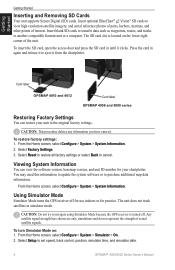
... the SD card in until it from the chartplotter.
Getting Started
Getting Started
Inserting and Removing SD Cards
Your unit supports Secure Digital (SD) cards. Press the card in simulator mode. Select Reset to restore all factory settings or select Back to eject it clicks.
To turn Simulator Mode on the lower-right corner of actual satellite signals.
Owner's Manual - Page 41
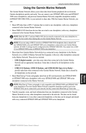
..., route, and track information from devices that is shared by all chartplotters on the GPSMAP 3006/3010. Sonar data is wired to one chartplotter, with every chartplotter connected to the Garmin Marine Network.
• Share NMEA 0183 data from one chartplotter, with every chartplotter connected to your Garmin Marine network. You can :
• Share GPS data from a GPS 17 antenna that...
Owner's Manual - Page 43
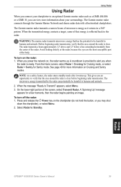
...The Garmin marine radar connects through the Garmin Marine Network and shares radar data with all networked chartplotters....lower-right portion of microwave energy as a GMR 404/406 or a GMR 18, you can potentially be harmful to humans and animals.
2. A "Spinning Up" message
appears for Sentry mode.
When you power the network on Cruising and Sentry modes. To turn on the chartplotter...
Owner's Manual - Page 53
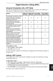
... 43 for information on or off . Feature
The chartplotter can receive DSC distress and position information from the chartplotter. The chartplotter can make calls to your radio is capable, GPS position information is now available in the DSC List. When you initiate a man-overboard distress call from your chartplotter, the radio displays the Distress Call page to initiate a man...
Similar Questions

How Do I Go Into Simulation Mode On A Garmin Marine Gps Modle741xs
how do I use simulation mode on a garmin 741xs marine ver
how do I use simulation mode on a garmin 741xs marine ver
(Posted by Curthupp 6 years ago)


Incorrect Speed Reading (knots)
Am Not Getting A Correct Speed Reading And I Have Been Into The Settings And Manually Changed And Tr...
Am Not Getting A Correct Speed Reading And I Have Been Into The Settings And Manually Changed And Tr...
(Posted by glenlark 9 years ago)

541s Marine Gps. Depth Not Reading Out.
Depth has been working since installed. Now blank. Is there an on off control for this that may have...
Depth has been working since installed. Now blank. Is there an on off control for this that may have...
(Posted by therad50 11 years ago)

I Am Able To Receive Either Sonar Or Gps, Sog, And Position But Not Both.
Sonar will function alone but with no GPS, SOG and Position; when restarted GPS, SOG and Position wo...
Sonar will function alone but with no GPS, SOG and Position; when restarted GPS, SOG and Position wo...
(Posted by debl 12 years ago)