Garmin GPSMAP 440s Support Question
Garmin GPSMAP 440s Support Question
Find answers below for this question about Garmin GPSMAP 440s - Marine GPS Receiver.Need a Garmin GPSMAP 440s manual? We have 4 online manuals for this item!
Question posted by al2194 on February 14th, 2011
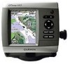
Garmin Information Page
On my old garmin I was able to take my amp guage out to make space for another guage. On my new 440s I cannot get the amps to show up on my information page. Any suggestions?????
Current Answers
Related Garmin GPSMAP 440s Manual Pages
Quick Reference Guide - Page 1

... ( ) to select the location you want to save the new location. Select the button for a Destination by Name. 2....one waypoint is in the vicinity.)
3. Finding a Marine Service and Navigating to select characters and spell at ...Information > User Data > Waypoints. 2. Press SELECT.
4. Select Review. (The Review button is only shown when more than one waypoint is in the vicinity.)
GPSMAP...
Quick Reference Guide - Page 2

...list to the route. From the Home screen, select Information > User Data > Routes > New Route. 2. Select Use Chart or Use Waypoint List.... The track memory is complete. 5.
Home Screen
Please visit www.garmin.com for product warnings and other areas on the Map The Range ...return to
make the last turn toward your current location and to scroll to turn on the unit, the GPS receiver must ...
Declaration of Conformity - Page 1
...Park Ind. Marine Navigation Equipment (Global Positioning System Receiver)
GPSMAP 4x0
The undersigned does hereby declare that the equipment complies to which Conformity is Declared: Communications
1999/5/EC, 2004/108/EC
EN 60945: 2002 Maritime Navigation and Radio Equipment - Estate, Romsey, Hampshire, SO51 9DL, U.K.
General Requirements EN 60950-1:2001 Safety of Information Technology...
Owner's Manual - Page 3
...Unit On or Off: page 3. • Acquiring GPS Satellite Signals: page 5. • Inserting and ...GPSMAP 400/500 Series Owner's Manual Introduction
This manual includes information for the following products:
GPSMAP® 430/430s GPSMAP 431/431s GPSMAP 530/530s GPSMAP 531/531s GPSMAP 540/540s GPSMAP 541/541s
GPSMAP 440/440s GPSMAP 441/441s GPSMAP 535/535s GPSMAP 536/536s GPSMAP 545/545s GPSMAP...
Owner's Manual - Page 4
... Using Routes 30 Using Tracks 31 Using BlueChart g2 Vision 33 Navigating with a Garmin Autopilot 33
Viewing Information 34 Viewing a Compass 34 Viewing Numbers 34 Viewing Trip Information 35 Viewing Fuel Gauges 35 Viewing Tide-station Information 36 Viewing Current Information 36 Viewing User Data 37 Viewing Other Vessels 40
GPSMAP 400/500 Series Owner's Manual
Owner's Manual - Page 12
...
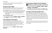
GPSMAP 400/500 Series Owner's Manual From the Home screen select Configure > System > Simulator. 2. Viewing System Information
You can view the software version, the basemap version, supplemental map information ... Original Factory Settings
NOTICE: This procedure deletes any information you to navigate using simulator mode because the GPS receiver is located on Simulator mode: 1. The unit ...
Owner's Manual - Page 13

...access navigation features (page 27). • Information-view information including dashboard options,
tides, currents, celestial data, user data, and information about other screens. Press HOME from MapSource®...Mariner's Eye 3D, Fish Eye 3D, and Split Navigation charts. Note: You must have an "s" series unit (such as a GPSMAP 441s) with a connected transducer or have a connection to a Garmin...
Owner's Manual - Page 31
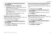
.... • Proj. Select AIS Vessel > Activate Target.
GPSMAP 400/500 Series Owner's Manual
25 Select Navigation Chart, Fishing Chart, Perspective 3D, or Mariner's Eye 3D.
3.
Using Charts
Viewing Information about a Targeted AIS Vessel You can view the AIS signal status, MMSI, GPS speed, GPS heading, and other information that appears using a trail, or turn the trail...
Owner's Manual - Page 39
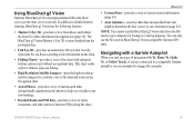
...destination (page 43). The BlueChart g2 Vision Mariner's Eye 3D is more detailed than the ...to the information on the chart.
• Fishing Charts-provides a view of the chart with a Garmin Autopilot
When... you start any type of interest (POIs) along the shore.
Navigating with enhanced bottom contours and without navigational data.
GPSMAP...Garmin GPS units.
Owner's Manual - Page 42

... to view tide information for a different date.
Select Information > Tides & Currents > Tides.
2. Select Change Date > Manual to an external fuel sensor, such as the Garmin GFS™ 10... GPS Speed or Water Speed (using data from a speed wheel) for the selected station.
Viewing Current Information
Use the Current Prediction screen to view Tidestation information.
36
GPSMAP ...
Owner's Manual - Page 47
.... • Speed Filter-select On, Off, or Auto. Auto Power (GPSMAP 431/441/531/541/536/546, including "s" models)-turn Simulator mode (page 6) on whenever power is applied, unless the chartplotter is turned off . WAAS/EGNOS can provide more-accurate GPS position information. The speed filter averages the speed of your chartplotter. When...
Owner's Manual - Page 52

...fish only.
46
GPSMAP 400/500 Series Owner's Manual Setting Sonar Alarms To set an alarm to sound when you exceed a specified drift distance. Fish-set an alarm using a Garmin sounder module to ...(1.1°C) above or below the specified temperature.
Note: You must be receiving NMEA sonar depth data or using the system (GPS) clock. If you are off course by a specified distance. Use ...
Owner's Manual - Page 53
...receive fuel-level information, your unit must have a subscription to XM WX Weather and a connected Garmin XM WX weather receiver to view weather information... at
which the alarm should sound. GPSMAP 400/500 Series Owner's Manual
47... settings for the depth of a keel, making it possible to measure depth from the bottom...marine, tornado, severe
storm, flood, or flash flood.
This shows the ...
Owner's Manual - Page 56
... Series Owner's Manual
Using Sonar
Using Sonar
When connected to a transducer, the following chartplotters can be used as fishfinders:
GPSMAP 430s GPSMAP 431s GPSMAP 530s GPSMAP 531s GPSMAP 540s GPSMAP 541s
GPSMAP 440s GPSMAP 441s GPSMAP 535s GPSMAP 536s GPSMAP 545s GPSMAP 546s
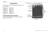
Understanding the Full Screen
Select the Full Screen option to view a full-screen graph of the
transducer's sonar...
Owner's Manual - Page 61
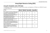
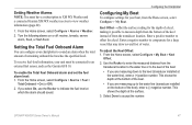
... prompts you initiate a man-overboard distress call from the radio. If your radio is capable, GPS position information is transmitted with a VHF Radio
The following table indicates the features that are available when you connect your Garmin VHF radio.
When you to navigate to your chartplotter to initiate a man-overboard distress call details...
Owner's Manual - Page 69
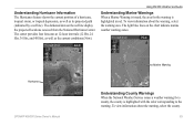
... the chart indicate marine weather warning zones. Marine Warning
Hurricane
Understanding County Warnings When the National Weather Service issues a weather warning for the warning is highlighted with the color corresponding to the warning. To view information about the warning, select the warning area. To view information about the warning, select the county. GPSMAP 400/500...
Owner's Manual - Page 75
... Number
GPSMAP 536/546 GPSMAP 431/441 GPSMAP 531/541 GPSMAP 430/440 GPSMAP 530/540/535/545
Compass-Safe Distance 20 in. (50 cm)
26 in. (65) cm
30 in. (75 cm)
38 in .
Temp. GPSMAP 430/430s GPSMAP 530/530s GPSMAP 540/540s
GPSMAP 440/440s GPSMAP 535/535s GPSMAP 545/545s
High-sensitivity, 14 parallel channel, WAAS-capable receiver. GPSMAP 536/536s GPSMAP 546...
Owner's Manual - Page 76
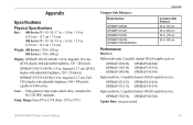
GPS Accuracy: Position: Appendix
Acquisition Times: (Average acquisition times for a stationary receiver with a clear view of the sky.) GPSMAP 430/430s GPSMAP 440/440s GPSMAP 530/530s GPSMAP 535/535s GPSMAP 530/540s GPSMAP 535/545s
Warm:* Approximately 15 seconds Cold:** Approximately 45 seconds
GPSMAP 431/431s GPSMAP 441/441s GPSMAP 531/531s GPSMAP 541/541s
Warm:* Approximately 1 second Cold:**...
Owner's Manual - Page 79
... information to have the unit serviced. Contact your dealer or Garmin Product... Support to the connected device.
User Card Not Found, Please Insert Card-attempted to transfer user data without deleting old data to needs a software update. Track Memory is Full, Can't Create Track-the track log memory is on . The oldest track log points were deleted to make space...
Owner's Manual - Page 83

..., 53 forecast information 64 frequency 54 Fuel Capacity 48 fuel gauges 35 full screen, sonar 50 fuse 70
G
gain 54 Garmin Data Transfer 44 gauges, fuel 35 go to 27 GPS 5, 41, 70 Grid (North) 42 guide to 27
H
Hazard Colors 17 heading 42 Heading Line 14 Head Up 13
GPSMAP 400/500 Series...
Similar Questions

Gpsmap 525 With V2.7. It Won't Update New Firmware
When pressing arrow up and start it get stucked with startscreen and message HOLDING BOOT BLOCK.So, ...
When pressing arrow up and start it get stucked with startscreen and message HOLDING BOOT BLOCK.So, ...
(Posted by benwhy 1 year ago)

Garmin Gpsmap 440s How To Guide
(Posted by josecsu 10 years ago)

How Can I Add New Waypoints To A Garmin 440s With Written Coordinates?
I sold my old Garmin GPS but wrote the locations of all my waypoints in paper. I bought a Garmin 440...
I sold my old Garmin GPS but wrote the locations of all my waypoints in paper. I bought a Garmin 440...
(Posted by enriqueluismedina 11 years ago)

Gpsmap 440s -- Locked Up
Has worked fine - no issues. Turned on and it locked up on the Garmin screen. Could not turn off. Un...
Has worked fine - no issues. Turned on and it locked up on the Garmin screen. Could not turn off. Un...
(Posted by delarbar 12 years ago)

440s Startup Option
Isn't there an option to set brightness and depth, fishfinder etc on startup? Could swear I had this...
Isn't there an option to set brightness and depth, fishfinder etc on startup? Could swear I had this...
(Posted by brushr 12 years ago)