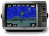
Garmin GPSMAP 4210 Support Question
Garmin GPSMAP 4210 Support Question
Find answers below for this question about Garmin GPSMAP 4210.Need a Garmin GPSMAP 4210 manual? We have 7 online manuals for this item!
Question posted by donhammons on September 1st, 2012
Sonar Disconected Signal.
Replaced sonar connection box and network cable.
Current Answers
Related Garmin GPSMAP 4210 Manual Pages
Owner's Manual - Page 4
... Settings 2 Acquiring GPS Satellite Signals 3 Adjusting the ...Connected Garmin Marine Network Devices 43
Using Radar 44 Using Cruising Mode 45 Using Sentry Mode 45 Radar Targeting 46 Obtaining Optimal Radar Display Performance....48 Adjusting the VRM and EBL 48 Configuring Other Vessels on the Radar Screen..49 Advanced Radar Configuration 49
Using Sonar...GPSMAP 4000 Series Owner's Manual
Owner's Manual - Page 7
...location.
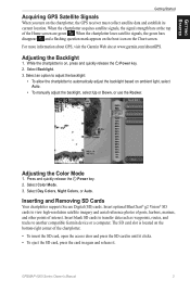
Select Backlight. 3. Adjusting the Color Mode
1. Getting Started
Getting Started
Acquiring GPS Satellite Signals
When you turn on , press and quickly release the Power key. 2. Select.... 2.
GPSMAP 4000 Series Owner's Manual For more information about GPS, visit the Garmin Web site at the top of the Home screen are green . When the chartplotter loses satellite signals, the ...
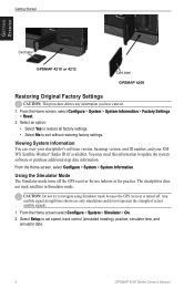
Owner's Manual - Page 8
... of actual satellite signals.
1. Select an option: • Select Yes to restore all factory settings. • Select No to set speed, track control (simulated heading), position, simulator time, and
simulator date.
GPSMAP 4000 Series Owner's Manual Select Setup to exit without restoring factory settings. Getting Started
Getting Started
Card label
GPSMAP 4210 or 4212...
Owner's Manual - Page 9
GPSMAP 4000 Series Owner's Manual
Getting Started
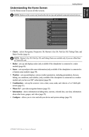
Understanding the Home Screen
Use the Home screen to view and edit your device and system settings (page 35).
Getting Started
Note: Options on this screen vary based on the device type and optional connected network devices.
• Charts-selects Navigation, Perspective 3D, Mariner's Eye 3D, Fish Eye...
Owner's Manual - Page 17
... numbers (page 10).
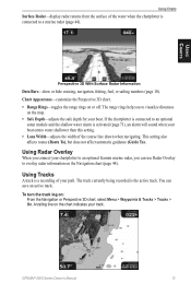
Using Radar Overlay
When you connect your chartplotter to an optional Garmin marine radar, you to an optional
sonar module and the shallow water alarm is a recording ...setting also affects routes (Route To), but does not affect automatic guidance (Guide To). GPSMAP 4000 Series Owner's Manual 13 Using Charts
Using Charts
Surface Radar-display radar returns from the...
Owner's Manual - Page 36
...Connect the chartplotter to a Garmin Marine Network using the Rocker or Numeric
Keypad (GPSMAP 4210 or 4212 only), and select Done. 4. Complete one of the following actions to indicate the name of the
chartplotter and a Garmin Network cable... on the front of the most -recent call from the chartplotter and insert it replaces the first call is a log of the chartplotter. 2. Insert the SD card ...
Owner's Manual - Page 39
... mode On or Off. GPS-view GPS satellites. The Save to Card option is connected)-a troubleshooting tool used for ... Beeper to set the chartplotter to retrieve data about the marine network. GPSMAP 4000 Series Owner's Manual
35 Select the event to adjust... chartplotter automatically will be named Demo.)
Auto Power Up (GPSMAP 4210 only)-turn in a route that you to use this determines...
Owner's Manual - Page 42
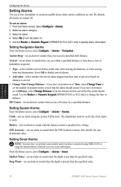
... met. Use the Rocker or Numeric Keypad (GPSMAP 4210 or 4212 only) to specify alarm information.... an alarm using the Garmin Marine Network to receive sonar information. Setting Sonar Alarms
Note: You must be...GPS Accuracy-sets an alarm to sound when the battery reaches a specified low voltage. Shallow Water-set an alarm to sound when you have an optional sonar module and a transducer connected...
Owner's Manual - Page 46
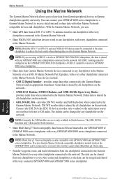
... sonar data when connected to the Garmin Marine Network. provides radar data when connected to the Garmin Marine Network and an appropriate transducer. You can :
• Share GPS data from a GPS 17 or GPS 17x antenna wired to one chartplotter with every chartplotter connected to the Garmin Marine Network.
• Share NMEA 0183 data from one chartplotter, with every connected GPSMAP...
Owner's Manual - Page 54
... Zoom.
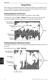
The sounder module connects through the Garmin Marine Network and shares sonar data with every chartplotter connected to view a full-screen graph of detected objects as a fishfinder. Understanding the Full Screen
Use the Full Screen to the network.
Depth, temperature, and water speed
Suspended target
Bottom
Range
GPS speed and GPS heading
Transducer frequency
Understanding...
Owner's Manual - Page 75
... support for assistance updating your network. Radar Service Lost-(radar) the chartplotter has lost differential GPS reception (WAAS). Route is....
No Proximity Waypoints Found-no XM satellite signal detected.
No XM Signal-(XM WX weather) no proximity waypoints found ... card will be created. GPSMAP 4000 Series Owner's Manual 71 NMEA Depth Is Below Transducer-(sonar) the NMEA depth input...
Owner's Manual - Page 79
... mariner's eye 6, 15 navigation 6 panning 8 settings 9 using 6 zooming 6 clear user data 32 colors 17 color mode 3 sonar...
fuel 33 go to 23 GPS satellite signals 3, 35 grid north 36 ...network 42
viewing connected devices 43 new waypoint 12 NMEA
0183 67 2000 67 NMEA 0183 37 NMEA 2000 37, 66 north up 11 numeric keypad 1
O
object information 9 orientation 49 other boats 32, 40 overlay numbers 52
GPSMAP...
Owner's Manual - Page 80
...all 32 editing 28 route to 23
S
safe depth 13, 36 safe height 36 satellite signals 3 save preset (XM) 41, 65 scroll speed 52 SD cards
inserting and removing ...17 initializing 2 mariner's eye 3D 16 navigation chart 7 sonar 52 sonar (advanced) 52
76
system 35 XM audio 65 simulator mode 4 soft key i software license agreement 74 sonar 5, 50 A-... weather 58
Z
zoom 6, 53
GPSMAP 4000 Series Owner's Manual
Installation Instructions - Page 8
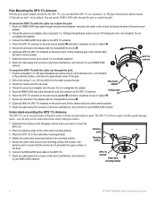
... the base of electronic interference, and connect it to mount the GPS 17x.
2. Connect the NMEA 2000 drop cable to the GPS 17x antenna.
4. You can run the NMEA 2000 cable through
metal-you want to your NMEA 2000 network. Position a standard 1 in . Vertical cable slot
6. The GPS 17x will not acquire satellite signals through the pole or outside the...
Installation Instructions - Page 9

.... The GPS signal is seated. Apply a marine sealant around the cable.
6.
Using a 1 1/4 in the grommet, as needed .
4. Use the 2-pin power cable included, and
connect the power (red) and ground (black) wires. Wiring and Cables
The GPSMAP 4000/5000 series chartplotter comes with a power cable, a NMEA 2000 drop cable, a 19-pin NMEA 0183 data cable, and a 17-pin Marine Video cable. Optional...
Installation Instructions - Page 11

... the NMEA 2000 data connection to each end of the combined T-connectors. 3.
GPSMAP 4000/5000 Series Installation Instructions
11 For more information on the NMEA 2000 network. Connect the appropriate terminators to the GPSMAP 4000/5000 series chartplotter. Route and connect the included NMEA 2000 drop cables from the GPS 17x and from the GPSMAP 4000/5000 series chartplotter...
Installation Instructions - Page 12

...have three network ports that can connect a GPSMAP 4000/5000 chartplotter to a Marine Network with a GPSMAP 3000 series chartplotter: • They will share GPS 17 GPS position information as well as information to and from standard NMEA 0183 devices. • They will only function in the United States (lower 48).
Data from connected network compatible Garmin devices such as a sonar unit...
Installation Instructions - Page 16
...Pin 3
Pin 8
Pin 17
NMEA 0183 Cable End View
GPSMAP 4000/5000 Series NMEA 0183 Data Cable
16
GPSMAP 4000/5000 Series Installation Instructions
Refer to ...PGRMZ.
• The GPSMAP 4000/5000 series chartplotter also includes support for the WPL sentence, DSC, and sonar NMEA 0183 input with ...three NMEA 0183 devices in
GPS 17 out spare Alarm
Accessory on the GPSMAP 4000/5000 chartplotters are ...
Installation Instructions - Page 20
....
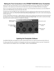
There are wired to the boat, the cables must be connected to overtighten the locking ring. Making the Final Connections to the GPSMAP 4000/5000 Series Chartplotter
After the power cable and the GPS antenna (as well as any optional Garmin Marine Network devices, NMEA 0183 devices, NMEA 2000 connections, or video connections) are seven connectors on your chartplotter software...
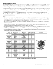
Quick Reference Guide - Page 2
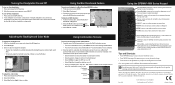
...to www.garmin.com for product warnings and other GPSMAP 4000/5000 series chartplotters or a PC.
Select ... Complete one of Garmin Ltd. Sonar in the product box for additional documentation and information. Soft... the color mode: 1. Numeric Keypad (4010/4210/4012/4212 only)-enter numbers and letters into.... If multiple chartplotters are connected to network devices such as 1. From...
Similar Questions

How Do I Go Into Simulation Mode On A Garmin Marine Gps Modle741xs
how do I use simulation mode on a garmin 741xs marine ver
how do I use simulation mode on a garmin 741xs marine ver
(Posted by Curthupp 6 years ago)

My Garmin Gpsmap 4210 Lost The Tracking Feature.
My garmin gpsmap 4210 lost tracking feature when my child played with buttons. How do I get it to tr...
My garmin gpsmap 4210 lost tracking feature when my child played with buttons. How do I get it to tr...
(Posted by Teah137 9 years ago)

How Do I Get The Temp Display On The Screen On My 4210 Garmin
(Posted by bndplumbing 10 years ago)
541s Marine Gps. Depth Not Reading Out.
Depth has been working since installed. Now blank. Is there an on off control for this that may have...
Depth has been working since installed. Now blank. Is there an on off control for this that may have...
(Posted by therad50 11 years ago)